For much of the nineteenth and twentieth centuries, South Yorkshire was synonymous with the coal industry. The stereotypical images that generally come to mind are of towering pit head machinery, mountainous spoil heaps and vast railway sidings.
However, this walk takes us back to the early 1800s when coal extraction was in its infancy, when more primitive techniques of mining and transportation were used, and the industry had less visual impact on the landscape.
Beneath our feet is the ‘Silkstone seam’, one of the most famous deposits of coal in South Yorkshire. Coal from the Silkstone seam was desirable for its quality to give off considerable heat while leaving little ash after burning. Most villagers – young and old, men and women, boys and girls – were involved in mining coal from the Silkstone seam. It shaped the economic and social life of the area, as well as the physical landscape.
We start the walk in the village of Silkstone Common which is on a ridge and descend to the neighbouring village of Silkstone in the valley below. Along the way we will explore sites of early mining operations, learning about the ways in which pits and shafts were dug, and envisaging the maze of underground tunnels.
We will follow in the footsteps of coal, finding out how it was transported across the undulating landscape from the colliery to the nearest canal via a special waggonway. We will also discover something of the social history of the mining community from the wealthy mine owners to the poor mine workers, and understand the impact of coal on the local economy. Weaving a thread throughout is the story of a mining disaster that changed the course of history in Britain.
This walk was created by Granville Daniel Clarke, a celebrity artist, poet, songwriter and musician, who has lived in the area for nearly 40 years. He has illustrated the walk with his own drawings, paintings and poems.
From the road, go through the opening into Nabs Wood. Go past the information board and down the steps. Cross the bridge over the stream and look on the left at a low stone sculpture featuring two crouching figures.
2 Children of the dark
We start our story of coal with a disaster that was a devastating loss for the local community but went on to have an impact on the national level.
This stone sculpture remembers 26 young children who died in a mine close to here on 4th July 1838.
As usual, the trap doors to the mine entrance were closed in order to force the air flow in a particular direction and flush out any pockets of deadly fire damp gas emanating from the coal deposits.
It was a hot summer afternoon. Up above, a thunderstorm broke.
Three inches of rain fell in a short period of time, putting out the boiler fire and hailstones broke the glass of the engine house.
The pit headgear pulley system was rendered useless and there was no way to bring the miners back to the surface.
A message was sent down to the men, women and children working in the mine to go to the bottom of the shaft and wait until the steam engine was working again.
After eight hours of working, and against the advice of the older miners, around 40 children decided to make their way out.
Sadly 26 were to die in the process of escaping; we’ll find out more a little further into the wood.
This memorial featuring two children crouching in their work places was created by local sculptor, Tony Slater, in 1988 on the 150th anniversary of the disaster.
As we continue up the path, we will pass through a tunnel of saplings which were planted in commemoration by 26 local school children of the same age as those who died.
Huskar mining disaster memorial sculpture in Nabs Wood
Facing the memorial, go up the steps to the right. Where the path divides, keep right through the sapling tree tunnel. Stop by the dry stone wall on the right which looks out onto a field.
3 From swamp to seam
Most coal was formed between about 360 and 300 million years ago when dense swampy forests covered the area.
Essentially coal is an accumulation of soil and decayed vegetation that was slowly buried and compressed then gradually solidified into rock under the forces of pressure and heat.
Coal is found in layers called ‘beds’ or ‘seams’. However, millions of years of geological history have passed since coal formed and various forces of nature have sculpted the landscape that you see today.
These have bent, warped and tilted the seams of coal from their original horizontal layers. And while some coal seams are found near the surface, others are deep underground.
In the South Yorkshire Coalfield (an area between Barnsley, Doncaster and Sheffield) the Silkstone seam is actually the deepest seam of any size. However, due to the lie of the land, it ‘outcrops’ at the western edge of the coalfield; in other words the seam comes very close to the surface and therefore is relatively easy to access.
This outcrop runs in a south-southeasterly direction from Cawthorne through Silkstone and Chapeltown to Dropping Well. Nabs Wood here is located along this outcrop and was therefore one of the sites where mining took place.
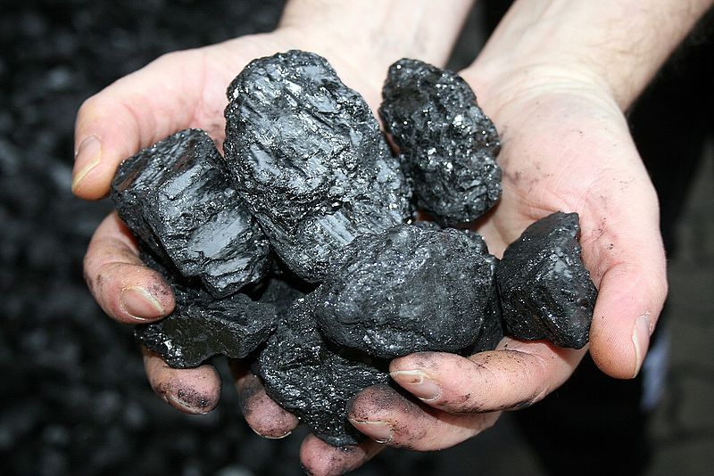
‘Black gold’
Powerhauer, Wikimedia Commons (CCL)
Directions
Continue following the path through the woodland as it ascends steadily. After a short distance look for a large hole to the left of the path with a wooden rail around.
4 Day holes and drifts
We have already discovered that the depth and orientation of coal seams vary. The positioning of a seam influences the method of mining used to extract the coal.
Layers near the surface can be mined by ‘opencast’ methods while deeper layers are mined via shafts that are sunk into the ground.
In the days before large machinery, a method known as ‘day-hole mining’ or ‘drift mining’ was used to access coal that was near the surface.
As the term ‘day-hole’ implies, a large enough opening in the ground would allow daylight working of the coal deposit. This hole in the ground is the former entrance to a day-hole.
Once the miners reached the coal seam – the largest was three metres thick – they tunnelled or ‘drifted’ along it, removing the coal as they went using picks and shovels, until they joined up with the next day-hole.
Another method used in the early days if the coal seam was a little deeper was ‘shallow shaft mining’; a downwards shaft was dug in a circular shape with wooden supports along the sides to hold back the surrounding rock.
This day-hole was part of the Huskar mine, ‘huskar’ being a corruption of House Carr (House Carr Lane was the road where we started). The Huskar mine was one part of Moorend Colliery which comprised a network of pits and tunnels that expanded for about a mile’s radius from where we are standing. The network was limited by faults – cracks in the strata which caused the seams of coal to suddenly change their depth from the surface.
Moorend Colliery was one of several mine workings in the area owned by the Clarke family and we will find out more about them later.
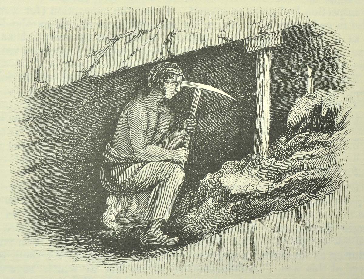
Collier cutting coal by candlelight
From the Royal Commission Report (1842)
Directions
Continue following the path up through the woodland which goes up some steps and bears round to the left. Stop when you reach a crossing over a stream.
5 A tragic end
At the memorial sculpture we found out the first part of the story of the Huskar mining disaster. Here by this stream we can discover what happened next.
Those down the mine had been asked to wait at the bottom until the boiler was relit following the storm. But, having already worked for eight hours, 40 children decided to make their way out. They fumbled through the dark towards the day-hole where we were at the last stop.
Due to the lie of the land, steep gorges like this are vulnerable to flash flooding. Unbeknown to the children, the heavy rain had filled House Carr Dyke with water. Suddenly, the weight of water swept away one of the trap doors and the torrent of water entered the day-hole, sweeping them back down the shaft with its force.
When the water met the next closed ventilation door it began to fill the tunnel space, trapping the children. Some older children managed to climb above the raging torrent and escape along slits in the mine wall but sadly 26 youngsters aged between 7 and 17 drowned.
We will find out more of the aftermath of the disaster and the subsequent public inquiry later.
Cross the stream and climb the steps on the other side. Follow the path through the woodland which brings you back to the memorial sculpture. Go up the steps to the entrance of the wood. Turn left onto House Carr Lane and stop underneath the railway bridge.
6 The Silkstone Waggonway
Having discovered how coal was mined in the early days, we are now going to find out how it was transported from isolated countryside locations such as Moorend Colliery here to its intended destination.
This bridge once carried the Sheffield to Manchester goods line but it was built in 1888. Had this railway line been here when Moorend Colliery was first operational half a century earlier then life would have been much simpler.
The landscape here is undulating and the gradients were too severe for the low-powered locomotives available in those days. Instead an alternative method was needed for transporting the coal to the Barnby basin on the Barnsley Canal about 4½ miles away.
The coal needed to be taken up to the top of Silkstone Common, over the ridge, down the other side to Silkstone, then along the valley bottom to Barnby canal basin.
While horses could haul heavy waggons on the flat, they could not manage the gradients up and down the hill.
The solution was a special tramway that comprised a combination of methods of transporting the goods. We are now going to follow in the footsteps of coal on its journey along the Silkstone Waggonway.
Continue up the road which changes name here from House Carr Lane to Moorend Lane. After about 150 metres stop outside a row of Victorian cottages on the right side which is known as South Yorkshire Buildings.
7 Houses for the workers
While these buildings stand a little outside the time frame of our walk story about the early days of coal in South Yorkshire, they are part of the broader industrial history of the area and deserve a mention.
While the workers employed in the early Moorend Colliery would have been poor villagers probably living in very basic conditions some later industrial workers had a better quality of life. This is actually a unique complex of Victorian workers’ cottages which were built in 1877.
They were originally built by the South Yorkshire Coal and Iron Company, owned by Messrs Haynes and Lawton as temporary homes for the workers constructing the railway between Worsbrough and Penistone via Silkstone Colliery. The company’s name is embossed in stylish Victorian text on the front gable of Numbers 4 and 5.
There are 56 dwellings built in a rectangular design – side to side and back to back. The larger end terraces were occupied by foremen while general workers were housed in the inner terraces.
All properties had a Yorkshire range for heating and hot water, a ‘set pot’ (a round bowl with brick surround and fire underneath) for washing clothes, an outside lavatory and a coal store.
In addition, all properties had an allotment on a nearby plot of land to grow their own produce (still operational today).
This self-contained complex used to have two general stores, one of which was cottage Number 8 on the corner, as well as being served by a travelling butcher.
When the railway was completed many properties were left empty but subsequently used by the army around the turn of the century.
The derelict buildings became popular nesting spots for sparrows and, according to rumour, nets were erected to catch them. Locals still call this ‘Sparrow Barracks’.
Around 1925 some properties were occupied by local miners while some were empty and semi-derelict.
Penistone Urban District Council, who had inherited them from the now-defunct Coal and Iron Company, allowed the homes to be purchased for £25 each instead of demolishing them.
In the 1960s the properties were under threat from demolition again, this time by Barnsley Council which was trying to modernise the village, but a spirited campaign by locals saved the buildings. The properties were connected to mains water in the 1970s and have since all been modernised.
This is now the largest remaining example of workers’ homes in South Yorkshire. Numbers 4 and 5 still have their original outbuildings at the back but the extent of renovations to the complex as a whole restricted a heritage listing in the early 1990s.
Do turn in by the first cottage (Number 8) to have a closer look. Take the first opening on the left to the ‘backs’ and you can appreciate the quadrangle layout and get a feel for this self-contained community.
These homes now provide cheaper housing in this now-desirable semi-rural area.
In the Daily Telegraph’s Village of the Year competition in 2000 Silkstone Common was voted the runner-up in northeast England! Things have certainly come a long way in 200 years!
When you have looked inside South Yorkshire Buildings, continue up Moorend Lane. Immediately after passing Silkstone Common Primary School, turn left through a gate into a small woodland known as Orchard Wood. Follow the path up the side of the school and bear round to the right at the top. Where the path forks, bear left onto an open grassy area.
8 Ride the black horse
Our walk up the road and through the wood has been following in the footsteps of coal on the Silkstone Waggonway. Modern building developments do not allow us to walk the exact line of the waggonway but we can crisscross its path.
Waggons were loaded with coal at both Moorend and Husker Pit shafts and brought by horses along waggonway branches to the valley bottom (near the cottages below the railway bridge neither of which had been built then).
The main line of the waggonway then ran from the junction of these two branches up a steady incline to the top of Silkstone Common.
The single rail track went in a straight line up the hillside – slightly diagonally in comparison to today’s Moorend Lane – crossing the land where South Yorkshire Buildings now stand and upwards through what is now Orchard Wood.
Do look at the original route map for a better sense of orientation.
A steam engine was located at Black Horse Farm at the top and known as Black Horse Engine. It powered a winch that hauled the waggons of coal up on a pulley system of ropes.
At this point, the waggons would have been nearing the final part of their steam-powered journey up the hill. Look towards the exit gate at the top corner of this park area: this was the track bed.
Now we can only see faint traces like these of the route of this part of the waggonway but its history is not forgotten.
Look on the map at the road parallel to this park: it is a residential road of new housing built in the 1990s but it has been called Black Horse Drive and Black Horse Close.
Just through the gate on the left are the white cottages of Meadow View which are the few miners’ homes from that period remaining in the village.
Leave the open grassy area by the gate at the top corner onto Woodland View. Walk along Woodland View until you reach the main road (Knabbs Lane) and turn right. Cross carefully when you see the pedestrian entrance to the railway station. Use the pedestrian crossing to go over the tracks, taking great care to look and listen for trains. Go through the gate on the other side onto Cone Lane. Look on the low wall immediately opposite for a plaque that reads ‘Black Horse Tunnel’.
9 Over the top
We are now at the top of Silkstone Common and the next stage in the journey of coal along the waggonway.
Having been hauled up the hill from Moorend Colliery on a winch driven by the Black Horse Engine, the coal waggon was unhitched from the steam-driven system and attached to a horse.
Here at the top of the hill was a tunnel, known as Black Horse Tunnel. It was about 100 yards long and went under the turnpike road (and later the railway line).
It may have been built to reduce the final gradient over the top of the hill, or it may have been a convenient means for the coal waggons to avoid having to cross the turnpike road. The tunnel still lies beneath the hill but is now blocked off. The exit is just beneath your feet on the other side of the wall from the plaque (it is a private garden so please do not enter).
But going through the Black Horse Tunnel was by no means the end of the journey!
The coal now needed to be transported down into the bottom of the next valley. Shortly you will see the steep gradient that this involved.
On this side of the hill, there was also a rope pulley system but this one was powered by gravity rather than steam engine, as on the other side. It was known as a self-acting incline plane.
There was a double rail so that full waggons could descend as empty ones went back to the top. A brake drum system was installed to avoid accidents.
With your back to the station, turn right along Cone Lane. Just before the lane meets the bend in the main road, turn left along the public footpath signed Blacker Green. Go over the stile and follow the path between houses and gardens.
Cross another stile and shortly afterwards look on the right side for a horse ménage. This has been built across the route of the waggonway which made its way diagonally down the hillside towards Silkstone. Do take time on your way downhill to admire the expansive views both ways. This gives you a better feel for the undulating landscape of this area which posed such a challenge to the transportation of coal. It certainly engenders some admiration for the ingenuity of the system installed to haul the coal up hill and down dale with such basic technology.
Go over the next stile and follow the path down through the woodland. Note the very lumpy ground on the left which could possibly be more surface coal mining areas. At the bottom cross the small bridge over the stream and follow the path up the other side with a field on the right and a garden on the left. Once you are beside the house you reach Blackergreen Lane. Turn right along the lane. After the lane bends round to the left look for a stone stile on the right and stop beside it.
10 Where there’s coal there’s brass
Look at the map: follow the route of Blackergreen Lane in the direction that we have been walking. At the end is the main road and on the opposite side is a manor house called Noblethorpe Hall within an area of parkland called Noblethorpe Park.
This was the largest mansion in the village and home of the Clarke family who owned most of the mines in this area. They were very rich and would have wanted to keep their life away from the prying eyes of the ordinary villagers who toiled in their mines.
In 1792 Jonas Clarke, a solicitor by trade, had bought Noblethorpe Hall farm in Silkstone.
He started mining for coal on his land – his first mines were Noblethorpe Warren and Noblethorpe 2.
He soon found out about plans to construct a new canal to exploit the coal reserves in the area so he started to buy up other farms with the view of developing his coal mining operations and capitalising on this opportunity of a new means of transportation.
On the death of Jonas in 1822 his son Robert C Clarke took over. In about 1831 he laid a private branch of the waggonway into the Dove Valley to the south where he opened two new pits at Moorend and House Carr (Huskar).
From the profits of these activities, the original building at Noblethorpe was upgraded to a mansion in 1838. The Clarke family was the first to engage in industrial-scale coal mining. However, other mining entrepreneurs soon followed the trend and sank shafts or opened drift mines. The coal industry was flourishing; it was a ‘black gold rush’.
From the lane, go over the stile and follow the path across the field in front of the row of houses. At the far corner, go over another stile and into woodland. Follow the path with a cricket ground on the right. On this cricket ground were once the coal yards and the coke and gas operations owned by the Clarke family. The waggonway followed the stream in the valley bottom. Leave the woodland via another stile and go down the driveway with the football pitch on the right. Stop at the petrol station on the main road.
11 Boom times
The Clarke family’s expanding mining operations, and those of the other landowners, offered the opportunity for employment at a time when making a living was difficult.
People came from outside the area – records show they came from Leeds, Scarborough, Durham, Lincoln and even London – to work in the mines and associated industries. Because of ‘black gold’, as coal was known, the Silkstone area was booming.
In 1821 the population of Silkstone was just 807. By the 1861 Census it was 1,054 and by 1871 it was 1,291. Consider that this expansion was happening in all the villages around and you will realise that this was a time of great economic and social change.
Most family members – men, women and children – were being employed in the mines and associated industries. All employees were obliged to buy all their general supplies in the Clarke’s store, known as the tommy shop, which was located right here where the petrol station stands today.
From picks and shovels to clogs and candles, from whale oil for lamps to food for families. Wages were spent in the shop and thus the money went straight back into the mine owner’s coffers!
The Clarkes also ran an iron warehouse which supplied rails, waggonway and underground tramway spares and pit-ropes.
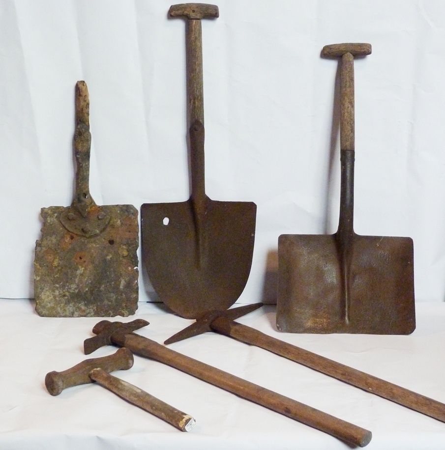
Miners picks and shovels
Courtesy of Silkstone All Saints’ Church
Directions
Go carefully through the petrol station forecourt. Cross carefully over the main road (A628 Barnsley to Manchester road) to a grassy triangle on the opposite side where there is a replica of a coal waggon.
12 Along the artery
So far we have followed the route of coal waggons from Moorend Colliery up to Silkstone Common, through Black Horse Tunnel and down the other side. From here it’s another two miles to the canal basin at Barnby.
This next part of the waggonway acted as an artery. In total about twenty coal mines like Moorend owned by the Clarke family and various other independent mine owners used branch lines that converged onto the central waggonway in the valley bottom.
Jim Ritche from the Roggins Local History Group here in Silkstone has been involved in creating this replica waggon that sits proudly at Silkstone Cross.
Jim: “This is a full size replica of a Silkstone coal waggon. It sits on cast iron rails and then on stone sleeper blocks on the original route of the waggonway.”
“Coal waggons were a statute size - they carried 53 hundredweights of coal - and were pulled by horses down the waggonway.”
“It was a single track but there were a number of passing points – especially on curves in the track - and the length of these passing points indicates that generally two horses would have pulled four waggons.”
We’re now going to follow the first part of the waggonway and find out more about it. As you walk along, look out for the stone blocks in the ground to which the rails were attached. They are more visible in some places than others.
Notice that the stones are placed in line corner-to-corner rather than side-to-side. This gave a wider support for the horses’ hooves as they pulled the waggons.
Locals are working hard to ensure that the historic waggonway is preserved. Colin Bower is involved in the Heritage Silkstone project as well as the Roggins Local History Group.
Colin: “The Silkstone Waggonway is one of hundreds in the country that existed in industrial areas in the days before the railways.”
“However, we’re very fortunate here that the waggonway is still largely in situ despite a considerable amount of building and development in the two villages that it passes through.”
“You can still follow most of the route and see original features including a tunnel, an earthwork, five bridges and hundreds of stone sleeper blocks. We estimate that it’s in the top 11 in the country in terms of the amount of original features still surviving. That makes it rather special.”
“Unfortunately the waggonway isn’t protected in any way. English Heritage would find it difficult to provide any protection as it is a linear feature without a clear boundary.”
“While the waggonway is accessible and open to the public it’s also vulnerable. We have had damage caused by contractors who - without knowing their significance - have dug up and removed some of the stone blocks and levelled some of the earthworks. This is a source of worry.”
“We are trying to develop a conservation management plan for the local authority not only because it’s an important heritage feature but because it’s an economic asset - people come here from far and wide to look at the waggonway - both experts studying it in detail and people just enjoying a day out.”
Carefully cross the road (High Street) and have a look at the information board. Follow the footpath at the back of the information board with the back of the buildings on High Street on your left and the stream of Silkstone Beck on the right. When you see the modern detached houses of Vicarage Farm Court on the left, look over the fence into the stream.
13 Coloured water
Although the mining industry has long-since ceased, its impact is still visible in the landscape. Look into Silkstone Beck, the small stream beside the waggonway. Can you see that the water in places is tinged with a rusty red-orange colour? This is ‘ocher’ (sometimes spelled ‘ochre’ and pronounced ‘ockker’ in Yorkshire-speak) and is an indicator of pollution.
The red ochre commonly seen in streams derives from ‘pyrite’. Pyrite is a natural mineral composed of iron and sulphur that can lie unchanged in rock or soil for thousands of years if there is a lack of oxygen – for example in a waterlogged meadow.
However, if conditions change and oxygen reaches the pyrite – for example if the meadow is drained – a chemical reaction occurs and the sulphur and iron separate. The sulphur washes through the soil and into streams as diluted sulphuric acid and the iron follows as ferrous iron.
If the conditions in the local stream are acidic then the ferrous iron becomes invisible in the water but is toxic and damages invertebrates and fish. However, if the acidity levels are diluted or reduced, another chemical reaction happens: the ferrous iron binds with oxygen dissolved in the water and turns into red ochre. In the transition between the two states the water becomes turbid and something resembling a thin oil film can appear on the surface of the water. Red ochre is not toxic but can nevertheless destroy habitats for animals and plants.
It is the mining and iron-working industries that have caused the red ochre in the stream here. Coal seams are rich in pyrite. Having lain undisturbed underground for millions of years mining suddenly exposes the rock to air and water, triggering the process of ‘oxidation’. In the years since works ceased, rainwater has filtered into the ground and passed through the old pits and shafts, continuing to release the toxic ferrous iron.
Pollution is no longer as bad as it once was. The Environment Agency have installed reed beds to filter out the red ochre and fish have returned to local waters. However, the rusty-red tinge serves as an ongoing reminder of the long-term impact of human exploitation of natural resources.
Continue along the waggonway path with the stream on your right. After about 150 metres cross a small footbridge over the stream on the right into Pot House Hamlet.
14 Pots, glass and grain
Although our walk is about the early days of the coal industry in South Yorkshire, we have stopped here to find out about the industries of the area in the days before coal and to reflect on the local economy in the days since coal extraction declined.
This complex of buildings is known as Pot House Hamlet. In the seventeenth century, a glassworks was located here, one of the first of its kind in Europe because it used coal instead of charcoal as a fuel. The surrounding hillsides had provided the fuel but trees were being depleted by the iron, glass and other industries so the use of charcoal was forbidden.
In the eighteenth century a pottery was located here; nearby Potter Hill provided suitable clay for making the pottery and earthenware and the kilns were fired by Silkstone coal.
There was also a mill here powered by water from Silkstone Beck. The original water wheel has left a groove in the mill wall, still visible inside the café. There is also a history of farming on the site. In addition the local area was known for the production of wool, linen weaving, brick-making and nail-making, all of which demonstrate the use of local natural resources for industrial production.
This site has been owned by the Horsfield family since 1938, as Tom Horsfield explains:
Tom: My father bought Pot House Mill Farm just before the Second World War. He was interested in horticulture but, because of the need to produce food for the war effort, he started keeping pigs and chickens. So he was a poultry breeder for many years. I can remember him taking the chickens in his special boxes - printed with ‘Henry Wallace Horsfield, Poultry Breeder’ - to the railway station and shipping them all over the country.”
“Having seen a lifetime of chicken breeding I wanted nothing to do with it! The site was only 36 acres so a bit small to be a farm but I was very interested in rose-growing. I became a specialist rose-grower for many years and exhibited all over the country at shows. When the garden centre era started, I branched out into all types of plants and built a garden centre.”
“In recent years we have made use of all the historic buildings on the site while developing modern businesses – a café, women’s wear and the garden centre. We’ve made it into a place to visit along the historic waggonway and stream.”
Pot House Hamlet is an excellent example of how a former industrial site can be transformed. It is a modern complex for local businesses which retains the character of the old buildings and celebrates the heritage of the site.
The site has been deemed a National Ancient Monument due to the unique glassworks and pottery history while the restoration of the old mill into the Potting Shed Café won the Gold Millennium Design Award for Barnsley. It has the best of both worlds.
The end of an industry can sometimes sound the deathknell for villages that depended on it but this initiative proves that villages such as Silkstone can have a life after traditional industries have declined.
The Potting Shed Cafe is highly recommended for refreshments, lunches and ice creams. You may wish to stop now or come back at the end of the walk which finishes a short distance away.
When you are ready, go back across the footbridge and turn right along the waggonway. Cross the main road (Barnsley Road) carefully and continue straight along the waggonway. Stop when you reach a widening of the path where there are some rails and a plaque in the wall on the right. There’s a bench here if you need a rest.
15 From waggonway to waterway
We have walked some distance along the Silkstone waggonway now and it is time to find out more about why it was constructed and how it operated.
In the early 1790s coal was being mined across the region but was generally used by industries located close to the mines. There simply wasn’t the infrastructure to distribute it across the region.
The Barnsley Canal Company was interested in constructing another canal to access the coal reserves in the Barnby area near Barnsley to meet increasing demand.
In 1792 the canal engineer William Jessop suggested a 14½ mile route from the Aire and Calder Navigation near Wakefield through Barnsley to Barnby.
The first section was completed in 1799 and the Barnsley to Barnby section opened in 1802. The Low Moor Company had a colliery at Barnby Furnace and constructed a half-mile tramway between there and Barnby basin. The colliery ran into difficulties soon after the canal opened but the company decided to extend the tramway a couple of miles further to Silkstone where there were more collieries. In fact, more collieries opened as the waggonway was laid. The route to Silkstone opened in 1809 and Barnby basin was enlarged to cope with the expected trade.
The waggonway runs immediately parallel to Silkstone Beck which is the flattest route along the bottom of the valley. As we have already discovered, it acted as an artery with branch lines from different collieries joining the main line. In total it was 8 to 9 miles in length including the various branches.
There was just one set of rails but, obviously, waggons needed to go back-and forth so there were passing areas at various intervals along the track.
Having taken their load of coal to the basin, the waggons did not return empty – other goods were brought in by canal barge and taken back to Silkstone and the villages beyond to supplythe mines and associated industries.
The waggonway was soon a great success. By 1814 around 85,000 tons of coal from the Silkstone seam was transported along the waggonway in a 12 month period. This was even before the tramway was extended to Moorend Colliery in 1830.
Clarke’s coal was now connected to the rest of the country through the growing canal network – there are records that it was exported to London. When the standard gauge railway came in 1851, Clarke opened coal yards at King’s Cross in London and his coal was sold in London and other towns along the expanding railway network. We also know that a three-hundredweight piece of beautifully marked ‘Peacock Coal’ from the Huskar Pit was sent to the Great Exhibition of 1851 at Hyde Park in London.
Continue along the waggonway for a short distance until you reach an area where there are piles of loose material – this is one of the last remaining colliery spoil heaps on the waggonway and known locally as Pop Pits.
Turn left and follow the track until you reach the road (Silkstone Lane). Turn left onto the road and walk along the pavement on the left side back into the village. Look out for Number 1 Highfield Cottages where there are several mining relics displayed in the garden that have been collected by the owner and a small information board beside the garden wall.
Continue along Silkstone Lane until you reach a major junction opposite the church. Cross over the road carefully (this corner can be busy) and go straight on into High Street. Walk along the pavement beside the wall of the churchyard until you are alongside a large stone memorial with a pyramidal apex. Go to Stop 16.
16 The price of coal
Here in Silkstone village we can find out more about the aftermath of the Huskar mining disaster of 1838 that we heard about at the beginning of the walk.
Beneath this grand memorial on the edge of the churchyard lie the remains of the children that died in the accident. The names and ages of the 15 boys and 11 girls who perished are etched into the stone. Many of the surnames on the memorial at the church are still found in the parish today.
The inscription states that “They died for the glory of God”. While that statement reflects Victorian attitudes towards religion, it does not capture the devastation felt by the victims’ families and the whole community. There was a terrible price to pay for the coal that brought jobs and wealth.
Bill Brown, a retired miner from Silkstone, reflects on his days in the industry and how it was different in previous generations.
Bill: “I spent my whole working life down the pit. I started in 1954 when I was 15 years old. My first job was at the screen, sorting the muck from the coal.”
“Then you were allowed to go down the pit when you were 16. They sent us to do some training then I started timber-tramming (taking timbers and props and bars to the face) and sometimes rope-running at the pittop.
“When I got to 18 we went for face training at Barnsley Main – that took nearly a year – and when I passed that, I went on the coal face.”
“I was young starting at 15 but the children that worked down the pits in Silkstone 150 years before me were only bairns of 6 or 7 years old.”
“It must have been terrible for them. We had electric lights but they just had candles. And there was no machinery in those days – everything was done by hand.”
“I don’t remember the Huskar disaster because it was too long ago but I’ve read about it and I know the place where it happened.”
“Thinking about it now it must have been terrifying – and for the parents as well. What are they doing at 6 and 7 now? They’re playing on their mobiles...”
Do take the opportunity of visiting the church which contains numerous information boards about Silkstone’s heritage (open Tuesdays and Wednesdays).
When you are ready, continue along the High Street. Stop when you reach The Red Lion pub on the right hand side. There is a large inscription on the wall to the left of the main door.
17 A Royal Inquiry
On 5th July 1838, the day after the Huskar disaster at Moorend Colliery, an inquest was held here at The Red Lion, a former coaching inn and the oldest pub in the village. The children who survived plus the pit managers gave evidence about the events on that fateful day. Child survivor, William Lamb, gave the following statement:
“We did not know what we were going out for, we thought it was a fire, the water washed the children down the day-hole against the door, through which we had just come, and they were all drowned. If we had stopped at the pit bottom we should have all been saved.”
At 11pm the inquest recorded a verdict of accidental death by drowning. But that was not the end of the story. News of the disaster – particularly the fact that the dead were all children – reached the press and a young Queen Victoria who ordered a public inquiry.
The ‘Royal Commission of Inquiry into Children’s Employment’ was carried out in 1840. It was divided into two parts: one investigation looked into the conditions of children working in mines while the other looked at manufacturing and other trades.
Investigators toured the country, visiting workplaces and interviewing not just the child workers but also parents, employers, clergymen, medical men, magistrates, teachers and others. As it was the days before photography, artists were employed to capture live scenes of children at work.
The Commission’s report on mining estimated that around 5,000 children (some as young as three) were forced to work in some capacity in mining activities.
When the report arrived back in Parliament MPs tried to suppress it. The evidence and illustrations were so shocking that they feared a public outcry. But they were also concerned about the mine-owners, some of whom were MPs.
In letters to The Times mine-owners expressed concern that their mines could not operate without children who could get into the workings where the seams were narrow.
Despite these vested interests, the report was leaked to the press and action had to be taken. The Mines and Collieries Act was passed in 1842 which prohibited all females and boys below the age of 10 from working underground in the mines, and the Factories Act of 1844 reduced the permissible working hours for children and women.
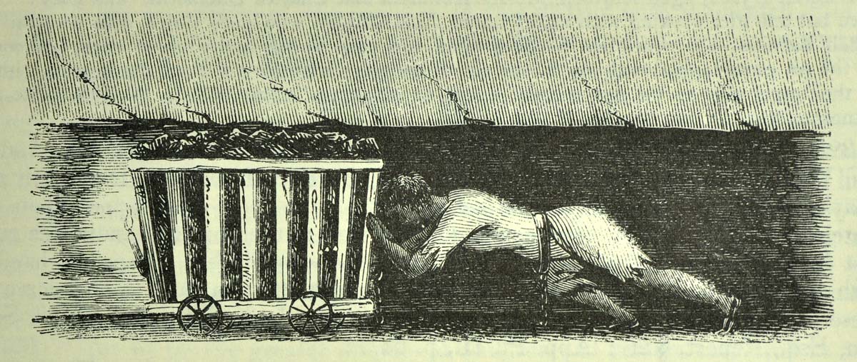
Child hurrier pushes corf
From the Royal Commission Report (1842)
Directions
Continue a short distance along High Street. On the left is Bells Steak House, once the Six Ringers pub. It was here in January 1843 that the first ever union meeting in the area was held. The following year the miners held an 11-day strike which resulted in the mine owners agreeing to reduce the working day to no more than 8 hours. Now look opposite at the entrance to Silkstone Primary School.
18 Children of the light
Here at the village school we can pause to reflect on how things changed for children following the Huskar disaster.
Despite the new Mines and Collieries Act that banned young boys and all girls from working very little changed locally.
Families still needed income to survive and there were no other employers in the area. Boys and girls went back down the pits. Lower classes simply did not have access to education.
But Silkstone got its first school in 1850 when Sarah Clarke, the widow of the mine owner R C Clarke, benevolently funded the building of Silkstone National Infant School. Life and prospects slowly began to change for young people.
Today’s children have free education and health care, televisions and mobile phones, access to the internet and opportunities for travel – and the chance to climb the ladder of life. However, the children of this area do sometimes pause to remember how fortunate they are.
In 2003 a book entitled ‘Children of the Dark’ was published telling the story of the disaster.
The story has also been told in a play entitled ‘Profit and Loss’. The local community have been involved in performing it for many years, including a special performance in Silkstone Parish Church on the 170th anniversary in 2008.
Back in Nabs Wood we saw the tunnel of saplings planted by 26 school children in memory of the 26 who died. In these ways, the local community never forgets the tragedy of history.
Still from a performance of ‘Profit and Loss’
Grass Roots Theatre Group
Directions
Continue along High Street back to the replica coal waggon at Silkstone Cross where we stopped earlier.
19 A transformed landscape
The replica waggon is a fitting place to end our walk that has traced the journey of coal. The waggonway was at the heart of Silkstone’s success.
Just 30 years on from the miners’ strike and the end of the coal industry in South Yorkshire, we’ve stepped back in time about 175 years to the earliest days of coal extraction.
It was the presence of a good quality seam of coal which was accessible near the surface plus the transport links that were developed that put Silkstone on the map in the early-nineteenth century.
We have found out about the landowners who began mining on their land and the network of small independent mines that emerged. We have learned about methods of surface mining using day-holes, drifts and shafts.
We have traced the route of a tramway which hauled the coal from a pit in one valley over the hill and into the next valley utilising ropes and pulleys, a steam engine and horses. We have walked along the arterial waggonway in the valley bottom which took the loads of coal onwards to the Barnby basin for nationwide distribution via the canal network.
We’ve also discovered how Silkstone became nationally-known due to a terrible mining disaster in which 26 children died and which went on to change the course of history.
Although we’ve been able to see some evidence of the mining industry in the landscape – such as the entrance to a day-hole and the stone setts of the tramway – the landscape has been completely transformed. The site of the Huskar day-hole is now a picturesque bluebell woodland and the waggonway is a pleasant riverside walk.
But the industrial past has not been forgotten. In plaques and memorials, in a replica waggon an information boards, in saplings and a dramatised story, the proud and tragic mining history of this area is respected and celebrated.
If you wish to return to Silkstone Common to collect your vehicle or catch a train, you can either retrace your steps up the footpath to the right of the petrol station or go up Cone Lane to the left of the petrol station.
Your browser is out of date, and unsupported by this website. Please upgrade to the latest version to use this website.
Child hauling coal, from the Royal Commission report into children’s employment (1842)
Silkstone walk
A walk in one of Yorkshire's famous coal mining regions
Coal from the famous ‘Silkstone seam’ - named after the village where deposits were found near the surface - was valued for its quality. Wealthy landowners started a ‘black gold’ rush and poor workers migrated from across the country to toil in the mines.
This walk follows the Silkstone Waggonway, which was made to take the coal from small countyside mines to canals into towns and cities.
Visit the sites of early mines and find out the primitive ways coal was extracted. See where a mining disaster devastated the local community but went on to change the course of Bristish history.
Also enjoy paintings, drawings and poems created especially for this walk by Silkstone artist, Granville Daniel Clarke FRSA.
Follow the walk by clicking on the map pins or downloading the guides below
Silkstone and Silkstone Common, near Barnsley, South Yorkshire
Start point:
Entrance to Nabs Wood, Moorend Lane / House Carr Lane, Silkstone Common, S75 4QZ
Finish point:
Silkstone Cross, High Street, Silkstone, S75 4JR
Silkstone walk credits
Granville Daniel Clarke FRSA for suggesting, researching and writing the walk, creating artwork and poetry especially, providing the audio commentary and photos (www.granvilledclarke.co.uk)
Jenny Lunn for editing the walk resources, acting as narrator and providing photos
Colin Bower, Secretary of Roggins Local History Group and Director of Learning for Heritage Silkstone project for sharing his immense knowledge, extensive archive searches and providing photos
Jim Ritchie, Chairman of Roggins Local History Group, for detailed explanation about the waggonway and help with archive searches
Margaret Bower for assistance with archive searches
Tom Horsfield, the owner of Pot House Hamlet, for sharing anecdotes from his family history
Bill Brown for reminiscing on his life as a miner
Barnsley Archives and Local Studies for permission to reproduce documents and maps from the Clarke Papers
Vallentine Mitchell & Co Ltd for permission to reproduce sketches from the Royal Commission Report on the employment and conditions of children in mines and manufactories (1842) and Steven Anderson of SA Pro-Imaging Ltd for photographing them
The National Archives for permission to reproduce a map of the Barnsley Canal
Roggins Local History Group, Silkstone All Saints Church, Silkstone Common Primary School and Andrew Horsfield for permission to use maps and images from their collections
Sylvia Le Breton from Grass Roots Theatre Group for permission to use stills from the play ‘Profit and Loss’
John Robertson and Brian Parkhurst for help with scanning images and photographs
 Jenny Lunn.jpg)
 Granville Daniel Clarke.JPG)
 Jenny Lunn.JPG)
 Jenny Lunn.JPG)
 Jenny Lunn.JPG)
 Granville Daniel Clarke 2014.jpg)
 Jenny Lunn.jpg)
 Granville Daniel Clarke 2014.jpg)
 Jenny Lunn.JPG)
 Granville Daniel Clarke.JPG)
 Granville Daniel Clarke.JPG)
 Jenny Lunn.JPG)
 Granville Daniel Clarke.JPG)
 Grass Roots Theatre Group.jpg)
 Granville Daniel Clarke 2014.jpg)
