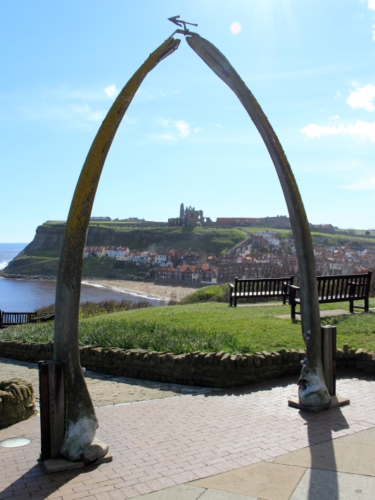
We start at one of Whitby’s most distinctive landmarks. The Whalebone Arch is a great place to survey the town. Like the nearby statue of Captain James Cook, we can gaze across Whitby’s natural harbour framed by dramatic cliffs. Notice the town’s many red roof tops and the haunting ruins of the Abbey opposite.
Below us the River Esk enters the North Sea. Whitby has always been shaped by the sea. By 1536 it was described as "a great fischar toune" known for catches of herring. These fish were such a source of food and income that locals called them "silver darlings". There were so many herring boats in Whitby that people could cross one side of the harbour to the other by walking across the decks.
This arch meanwhile is the lower jaw of a Bowhead whale, presented by Whitby’s twin-town of Anchorage, Alaska. The bones are another reminder of Whitby’s seafaring heritage. From 1753 to 1833 this was one of Britain’s key whaling ports. Take time to read the information board left of the Arch, which explains what the whales were caught for.
Whitby had over 50 whaling ships. The Arch marks the spot where the town’s women watched their husbands and sons leave the harbour each spring for the icy waters of Greenland. When the fleet returned in the autumn, whale jawbones were fastened to the boats’ masts and decorated with ribbons to signal a successful voyage. The smell of decomposing whale fat in the harbour was so dreadful it apparently made men weep!
Whaling was a dangerous industry. Shipwrecks, storms and harsh winters were common. Though Whitby no longer has a whaling fleet, fishing is still important - and the town’s fish and chips are a real delight! The Whalebone Arch is a sobering reminder though of the costs of working the seas.
An 18th century engraving of Bowhead whaling in the Arctic, Wikimedia Commons (CCL) - click on the image to enlarge
Directions
With the Arch on your left continue along the footpath. Stop when you reach an information board about Whitby Abbey. Turn left and go down the steps. Head towards a tunnel across the road but don’t go into it.
Instead turn right and follow the pavement along the left hand side of the road. After a short distance take the footpath on the left up the grass bank to reach the row of benches. Go to the last bench on the right – the one nearest a building with a distinctive coned roof. Stop here and look across the harbour.
2 Bram Stoker's bench
Today Whitby is world-famous for its links with a sinister fictional character – Count Dracula. Dracula is one of the most influential books of all time, spawning countless films, TV serials and nightmares...
But the story began right here in Whitby, all thanks to a fussy landlady.
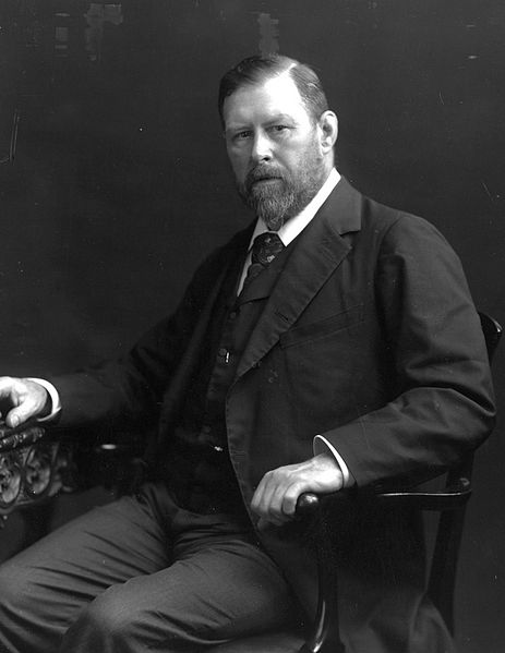
Bram Stoker was a young Irish writer who holidayed in Whitby in the 1890s. He stayed in a boarding house in Royal Crescent, around the corner from the Whalebone Arch. The landlady didn’t allow guests to remain in their rooms during the day, so Stoker took up exploring the town.
Stoker fell in love with Whitby’s towering cliffs and winding streets. This bench is said to be his favourite spot for writing and watching the activity below. One night in 1895 he saw a ship wrecked off the harbour during a storm. This dramatic event inspired Stoker to set parts of his new book in Whitby. The decision changed his career and created a legend.
In Dracula a ship runs aground off Whitby on a stormy August night: "strangest of all,the very instant the shore was touched, an immense dog sprang up on the deck from below”. The dog - Dracula in disguise - runs up the 199 steps to St Mary’s Church on the opposite cliff and the Count’s reign of terror begins.
Whitby and Dracula are now intrinsically linked. Every year thousands of people visit Whitby from around the world on the trail of the Count. The Dracula industry peaks in April and Halloween with the town’s popular Goth Festivals. For many, this bench is a site of pilgrimage. Can you imagine Bram Stoker sitting here, with pen and notebook in hand, or Dracula stalking the cliffs?
The view has hardly changed in 120 years. One alteration is the wooden fence ahead of the benches. The council put it up in 2013 to prevent people falling off the cliff - but for some it spoils the view. The controversy shows that Whitby’s natural landscape still inspires strong feelings and shapes the town’s fortunes.
Pictures:
Bram Stoker in 1906 / A first edition of Dracula Wikimedia Commons (CCL)
Directions
From the bench retrace your way along the path. When you reach the pavement turn right and stop at the tunnel entrance you passed earlier.
3 The 'Screaming Tunnel', Khyber Pass
Like many landmarks in Whitby this passage has become linked to Dracula. Some fans say this is his hideout, where his victims scream as they meet their fate. In truth this spot has a different kind of dark history. Looking at the tunnel, does it remind you of anything?
Though fishing was important in Whitby for centuries, poor roads over the surrounding North York Moors meant catches could only be traded short distances. Few Whitby goods passed York, 46 miles away. But in the 1830s a young entrepreneur identified a solution for expanding Whitby’s trade – the railway.
George Hudson built many of Yorkshire’s early railways and he completed a line and station in Whitby in 1839. Hudson’s railway helped to transform the town. Trains improved Whitby’s trade links and encouraged new visitors. People from across North Yorkshire, East Riding and beyond now chose Whitby as a holiday destination.
Hudson quickly saw Whitby’s potential as a seaside resort. He began building hotels and houses on the cliff top, including Bram Stoker’s haunt the Royal Crescent. This walkway, shaped rather like a miniature railway tunnel, was part of the development and provides a shortcut to the harbour.
By the 1840s, Hudson controlled railway companies across Britain. But “the Railway King” had a secret. In 1849 irregularities were found in his accounts. Shares in Hudson’s companies collapsed and he was declared bankrupt. So he fled to France, leaving the Royal Crescent only half built.
Hudson returned to Whitby in 1865 to stand for election as the town’s MP. He was arrested for corruption and spent three months in jail. Hudson’s sharp business practices aren’t the only legacy we’ll find in Whitby of shady dealing.
Turn your back on the tunnel and turn left along the road. This time follow the pavement as it curves around in a semi-circle to the right. Then turn left into Hudson Street. Continue along the left hand side and take the first left turn before the Corner Guest House.
Follow the narrow street all the way to the end. Pass a car park on the left and take care as there is no footpath for a short stretch. At the end turn left into Flowergate. Continue downhill towards a view of the Abbey.
At the pedestrianised area at the end of Flowergate, bear right and follow the sloping path downhill. Take your time as it is steep. Cross over the small road at the end and continue onto the bridge over the river. Cross the bridge and stop by the information board to the left.
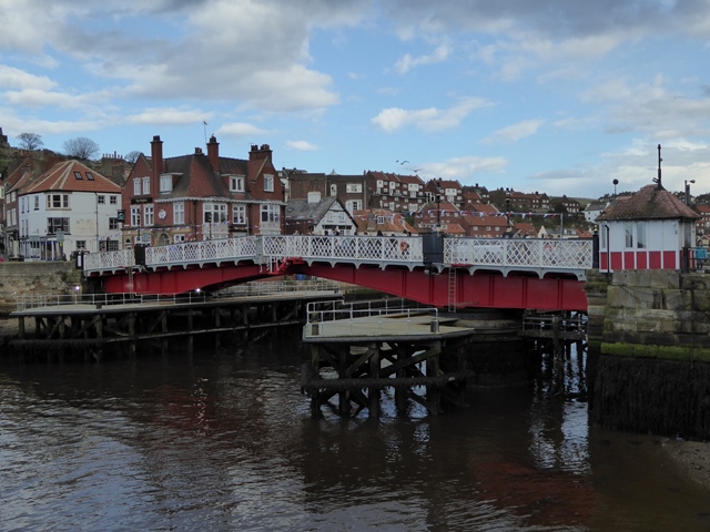
4 Information board beside Whitby Swing Bridge
There has been a bridge at this spot since at least medieval times. The current bridge over the River Esk was made in 1908 by the same engineers who built Blackpool Tower. Do look at the information board about Whitby’s bridges over the centuries.
So far we have explored Whitby’s West Cliff, which was transformed by Victorian developments. By crossing the bridge we are now at the bottom of the East Cliff, which has a much older story. Evidence has been found of a Roman signal station on the cliff top while the town itself grew from the 7th century after the formation of the Abbey.
If you are here on a weekend or in holiday season you will notice that this area can be very crowded. Whitby Bridge is the major route between the two cliffs.
Pedestrians, drivers and boaters all need to pass through it and during the busiest times it becomes a bottleneck. The bridge is sometimes closed off for safety reasons.
Crowding at the bridge reflects a wider trend. Whitby is very popular with second-home owners and retirees. But the town’s natural layout means finding room for everyone is difficult. The cliffs and surrounding moors limit the space for building new homes. With housing in shorter supply, prices are rising. This in turn means growing numbers of people can’t afford to live here.
Whitby is far from alone. From Cornwall to the Lake District, many areas face a balancing act between supporting residents and encouraging visitors. This is especially true in coastal towns where the natural landscape can be an obstacle as well as an attraction.
With your back to the river continue a short distance along the road. Take the first left and turn into the pedestrianised street (Sandgate). As you continue, notice the various shops selling black jewellery. Stop when you reach a cobbled square with a building with a clock tower in the centre.
5 The Market Building, Market Place
This cobbled square is Whitby’s historic market place. Several stalls and surrounding shops sell a local speciality – jet. Jet is often used in jewellery and looks like black stone.
It’s actually a type of wood, the fossilised remains of monkey-puzzle trees. Whitby is famous for jet and this unusual substance tells us what the area was like millions of years ago.
Whitby jet is 182 million years old. It formed in the middle of an era called the Jurassic Period. Then the land here was a boggy river delta with pockets of forest. Dead trees were soon squashed under layers of river mud. The decomposing trees released carbon dioxide gas, which heated the muddy mix into a thick sticky peat.
This peat gradually dried and built up in layers. The older layers underground were squeezed of moisture, forming solid black jet. Today Whitby is at the heart of a seam of jet that spans seven miles of North Yorkshire’s coast. Pieces of it wash up on the shores but jet has also been mined since the Bronze Age (1200 to 700 BC).
Whitby jet really took off in the 19th century. As the town became a resort, jet became a souvenir. After the death of her husband Prince Albert in 1861, Queen Victoria wore jet jewellery in mourning. Demand surged and by the 1870s Whitby had over 200 jet shops, employing around 1,500 people.
Though large-scale production has ended, Whitby jet is still a popular memento. But jet wasn’t the only ‘black market’ in this part of town. Whitby was a smugglers’ haven.
Smuggling was a way to avoid paying taxes on overseas imports and it became widespread in coastal towns. During the 18th century an estimated 80% of the tea drunk in Britain was smuggled, while so much gin arrived illegally it was used for cleaning windows!
Whitby’s market-goers wore loose-fitting clothes and returned home with their buttons bursting with smuggled tea, tobacco and alcohol. We can still see a legacy of Whitby’s “free trade” today. Remember all those red house roofs? Many are made with Dutch tiles called ‘pantiles’. These often arrived in Whitby as ballast in smuggling ships.
Queen Victoria in mourning attire, Wikimedia Commons (CCL)
Directions
Head towards the Market Building and turn left into the road behind it, Church Street. Continue along this road as it bears right then stop when you reach the bottom of a large set of stone steps winding uphill.
6 Bottom of Church Stairs (the 199 Steps), Church Lane
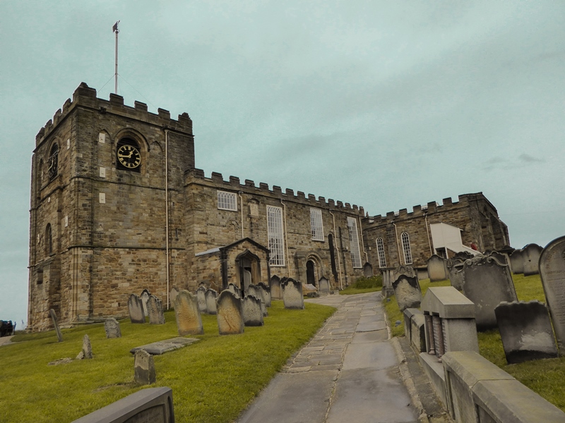
We are now on the way to St Mary’s Church. Founded around 1110, Whitby’s parish church is the oldest in the town. Visiting it means taking these 199 steps up the East Cliff.
The climb is well worth the effort for spectacular views over Whitby. Along the way are more clues to the town’s dark side.
The steps are numbered, so you can keep track of your progress - look on the left hand side for small round plaques with Roman numerals on. When you can see ‘CXCIX’ you’ve reached the top.
The steps are part of the Cleveland Way, a long-distance footpath which skirts the North York Moors for 110 miles. Established in 1969 it is Britain’s second-oldest National Trail. People have been walking up here for centuries though; notice grooves worn into the stone by the tread of countless feet.
If you need to stop for a breather look for small benches on the left, set in the handrail. But you might not want to sit on them for too long.
As well as helping the living, these steps carried the dead. Coffins were taken up here for burial in St Mary’s churchyard. Carrying these heavy burdens up the steps wasn’t easy, especially in bad weather. The benches are ‘coffin rests’ that allowed pallbearers to stop for a break. Hidden in plain sight, they provide a picturesque ‘final resting place’!
To reach the final stop of the trail you need to go up the 199 steps to the church (if you are unable to or don’t have time you can read the last stop while remaining in Church Street). When you reach the churchyard turn left before the church itself. Stop somewhere with the church behind you overlooking the harbour and West Cliff.
7 St Mary’s Churchyard
From St Mary’s churchyard, we can enjoy more views across Whitby harbour. The scene is like a mirror to the one we had at the Whalebone Arch. See if you can trace our route through the town.
The churchyard is yet another Dracula landmark. This is where the Count attacks his first victims and where the heroine, Mina Murray, hears that some of the graves are empty. Many record sailors, whalers and fishermen. Mina is told that when these men died at sea, families buried an empty coffin here to lay their loved ones’ souls to rest.
This is a spooky story but something even stranger has happened to occupied graves. Look around at the headstones. Notice many are very hard to read. And some are very near the cliff edge.
Years of wind and rain have worn off the lettering – and helped eat through the cliff. In Roman times the East Cliff extended past the harbour lighthouse. Since the last burial at St Marys (in 1865) several coffins have fallen into the sea.
The cliff is shrinking because of the ground beneath us. Much of the East Cliff is made from layers of ‘soft’ rocks, including sandstone and shale. ‘Soft’ rocks are easily worn away by wind and waves in a process called erosion. Furthermore, some of the rocks are ‘permeable’ - which means they let water pass through them - while others are ‘impermeable’ and can hold water in underground pools. This combination causes poor land drainage.
In late 2012 severe landslips occurred around the church. Bones were exposed in the graveyard while earth poured onto houses and shops below. Whitby’s soil and weather may seem banal topics, but these natural forces have more dramatic and ghoulish results than any horror story.
Throughout this trail we have uncovered many kinds of ‘darkness’, from smugglers and whalers to vampires and black fossils. But St Mary’s churchyard reveals perhaps the greatest threat to Whitby of all.
The landscape here, like much of coastal Britain, is constantly evolving. The power of the sea - which created the town and shaped its fortunes - may also be Whitby’s undoing.
From the churchyard you can visit St Mary’s Church if it is open and visit Whitby Abbey. The Abbey is looked after by English Heritage and an entrance fee applies. You can return to the town by taking the 199 steps back down the cliff.
Your browser is out of date, and unsupported by this website. Please upgrade to the latest version to use this website.
Whitby is a pretty coastal town surrounded by the North York Moors. Generations of holidaymakers have fallen for its scenery, seafood and literary links with Dracula.
But this is literally a town with two sides. Cut in half by the River Esk, Whitby lies between two steep cliffs. The landscape reflects a split personality, a town that revels in contrasts – sea and land, day and night, wealth and poverty, life and death…
This trail looks at some of the ‘dark’ and mysterious forces that have shaped Whitby long before a famous vampire sank his teeth into it...
Follow the trail by clicking on the map pins or downloading the guides below

 Stoker fell in love with Whitby’s towering cliffs and winding streets. This bench is said to be his favourite spot for writing and watching the activity below. One night in 1895 he saw a ship wrecked off the harbour during a storm. This dramatic event inspired Stoker to set parts of his new book in Whitby. The decision changed his career and created a legend.
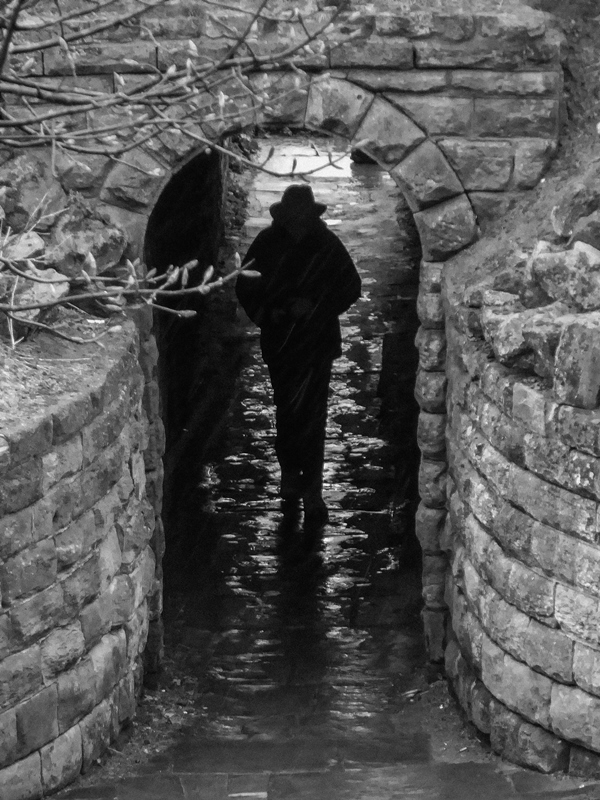

 Whitby jet really took off in the 19th century. As the town became a resort, jet became a souvenir. After the death of her husband Prince Albert in 1861, Queen Victoria wore jet jewellery in mourning. Demand surged and by the 1870s Whitby had over 200 jet shops, employing around 1,500 people.
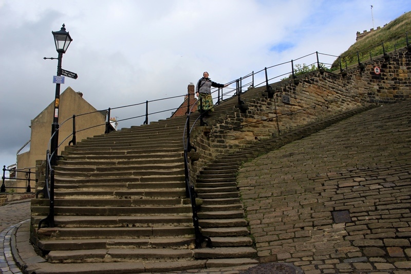

 This is a spooky story but something even stranger has happened to occupied graves. Look around at the headstones.
