To start the trail, leave Thornton Road and walk uphill along Ball Street, passing Thornfield House Nursing Home on your right hand side. As you reach the top of Ball Street, you will enter Market Street and immediately ahead of you there is a high, imposing triangular-shaped building.
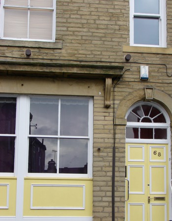
Stop here in front of this curiously shaped building teetering above you. This building has what is called a very small “footprint”, meaning it is built on a very small patch of land.
Today it’s a house, but it has also been used as a pub. Local people call it “Coffin End”. You can probably see why!
But why was it built in this particularly tall and thin shape? The answer lies in the land.
Look back down the hill from where you are standing, and you’ll notice that Thornton is surrounded by fields and by farmland.
Just 200 years ago, lots of small fields bordered the main street too, but when the fields were bought for housing development, the builders had to follow the old field boundaries. Because they couldn’t build outwards, they went upwards instead. This provided more accommodation and more profit.
Before continuing the walk, wander up Havelock Street and at the top you’ll come across a last remaining fragment of old farmland meadow.
Today the village with its pretty stone cottages and characterful cobblestone streets is an attractive place to stroll. It is quiet, pleasant and picturesque, but life here hundreds of years ago was dangerous, dirty and difficult. On this trail we'll find out why.
Directions
Standing on Havelock Street with Coffin End behind you, turn to your left and walk along Market Street. Stop at the corner with Springfield Street.
2 Junction of Market Street & Springfield Street
Take a close look at the buildings around you and you’ll notice that many still have their old shop fronts.
Some of these are new houses, and some are empty shops. Many of these shop frontages are over 100 years old and date from a time when Market Street was a busy high street full of grocers, bakers, cobblers and butchers.
Now see if you can find the large 4-storey building at the bottom of Springfield Street with the big square windows.
This was one of the earliest weaving warehouses in Thornton built sometime between 1830-1850. The large windows let in natural light for the weavers’ intricate work.
Small textile manufacturers rented space here to run their looms and as the industry grew, there were 9 mills in the village by 1900.
So if Thornton was a bustling village with plenty of grocery shops, new homes and jobs on offer, why was living here so deadly?
Think back to Coffin End and look around you at the houses which are small and crammed in next to each other. When these houses were built, they were put up quickly to provide almost instant accommodation for new and migrant workers demanded in the local stone quarries, mines, railway and in the textile mills.
But when these sound and solid little houses were constructed, they were built without fresh running water, toilets or good sanitation. Families had to collect water from wells outside in the street and share an outside toilet. There were many reports of drinking wells overflowing with sewage from the toilets.
In the Victorian era, large families were the norm. Living space was overcrowded and disease was rife. Average life expectancy here was only 21, and there was a very high infant death rate. Between 1800 and 1850 the population had tripled and the facilities were just not adequate.
Children worked in dirty and dangerous conditions to help provide for the family (many were employed to make shawls in nearby Springfield Mill). Altogether this was a very tough, and sometimes deadly place to live.
Directions
Retrace your steps along Market Street.
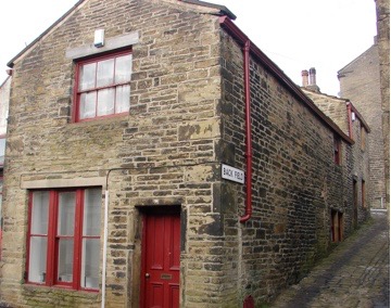
3 Market St, Bridge St and Back Field
As you walk (back) along Market Street, take time to explore this old part of the village. Notice that the houses become smaller and older. This part of Thornton dates from the late 1700s and early 1800s, when there were only 23 houses in the whole village. This was before the village exploded in size and when most people worked at home in small cottage industries or on the nearby farmland.
Turn right up the tiny cobbled Back Field. Look down to find an old coalhole, and up to see a bricked in doorway, previously a gantry (a door on the first floor for taking in wool).
Head back to Market Street and wander into Bridge Street opposite to see its tiny back-to back houses. Feel free to wander further up Bridge Street. Turn off and explore a maze of tiny houses from the early 1800s, with worn stone steps and tiny windows.
Imagine how it might have felt to live here back then, living almost on top of your neighbours in one of these tiny crowded homes. Picture the streets and houses lit by hand-held candles or oil lamps before gas and electricity arrived.
Directions
Now pick up your route again on Market Street and continue away from your starting point. As you walk along notice the date stones of the Kipping School Building on your left and on the stone cottages opposite the Black Horse Pub. The road heads downhill and bends slightly to the left and becomes Kipping Lane. Follow the road past the post office, staying on the right hand side and join Thornton Road at the corner by a small local park. You will be heading onto the other side of Thornton Road and onto Lower Kipping Lane, but the road here is very busy so walk uphill along Thornton Road and use the pedestrian crossing. Once you have crossed over Thornton Road, turn right and then left onto Chapel Street. Walk downhill along Chapel Street and veer slightly left at the bottom to join Lower Kipping Lane.
On Lower Kipping Lane continue right, downhill but don’t go too far, as you are looking out for a footpath sign on a lamppost on the left hand side. This directs you through an open stone archway, between some stone houses. Take this footpath and follow the stone path downward. This turns into a grassy soil path before meeting a stone bridge over a stream.
4 Stone bridge, Pinch Beck Valley
You are now at the foot of the Pinch Beck valley and on the edge of Headley Golf club.
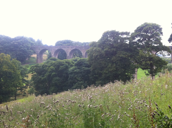
From here you can see a steep sided hill in front of you, a river at the bottom of the valley (the Pinch Beck) and a huge towering railway viaduct to your right hand side.
The valley and the fields beyond are a great open place to explore and enjoy today but before gas, electric and steam power, one very important source running through here provided the power and facilities that the wool and textile industries needed, water. Water was used to wash wool (sheared from sheep grazing the surrounding fields), to clean cloth and to power the water wheels and later steam pumps in the textile mills.
Many mills were built along the Thornton Road from Bradford all closely following the line of the beck. Largely due to its location, close to water power, sheep farms, skilled labour and with a central position in the country, Bradford was one of the largest and quickest growing hubs of the textile trade. Textile manufacturers invested in the factories, the roads and the railway (hence the impressive viaduct over the valley we can see from here). Thanks to this, the wool and fabric spun in these mills could be easily transported out to the rest of Britain and beyond.
Directions
From your position at the bottom of the field close to the beck and bridge, look straight up and slightly left to a group of trees on the brow of the hill. You will notice a faint path across the golf course between some grassy banks on the hillside. This will lead you towards the group of trees. It is a public footpath but do take care not to cross the golf course while golfers are using this green. When you reach the top of the field, walk ahead to where the tree line turns at a right angle. You will need to walk through a grassy path and go underneath the tree canopy, to find a stile with stone steps in the corner of the field, exiting the field through a metal gate. (If you find yourself on a short grass or stony path that leads under the viaduct you have walked too far to the right and you should re-trace your steps to find the stile in the corner).
Climb the stone steps and follow the path uphill, between two stone walls. The viaduct will be on your right, and farmland on your left. Continue straight ahead, crossing a muddy cow track to continue on the path ahead, again between two stone walls.
5 Footpath and views
From the path you will now have excellent views of the valley and village. Prominent in the valley is a very large group of buildings. This is Prospect Mill, a now run-down group of factory buildings that in their heyday employed 2000 people and also may children 'half-time' (working in the mornings and going to school in the afternoon).
This is a good place to stop and reflect on the enormity of these industrial buildings and to consider how it might have felt to work long hours in the huge, hot mill, surrounded by the lush and steep valley behind it.
Before legislation outlawed it, mill owners used children as cheap labour. They were uncomplaining and nimble fingered. Small girls worked in mills as ‘piecers’ mending broken threads. 'Scavengers' crawled beneath clattering machines to pick up scraps of cotton risking getting caught in the machinery, losing hair or even arms.
Despite the dangers, families were often dependent on the income brought in by their young children.
Directions
Follow the path until it meets a road, called Headley Lane. Here you will find a junction for many trail routes and there are multiple Great Northern Railway Trail and cycle signs. You will need to turn right and follow the cycle trail right, signposted to Thornton. This path leads you along a broad tarmac path under a small bridge (this is the cow track that you crossed previously!). You are now walking along the of the old railway track and will find boggy ground full of wildlife to your left as you continue along the tarmac route. As you continue, you will emerge onto the top of the viaduct itself.
6 Thornton viaduct
You’re now standing on top of the Thornton viaduct. At 120 feet high and 270 metres long it dominates the landscape here. Viaducts like this are usually built to connect two points of similar height in a landscape. Here it carries the railway line over the Pinch Beck Valley and joins Thornton to Bradford.
Construction began in 1878 and took a year. Like many of our great engineering projects, it was built on the back of migrant workers called navvies who lived and worked in difficult conditions for low pay. Three people lost their lives. It is worth pausing for a moment to imagine how difficult and dangerous their work was. Imagine working at such high altitudes and in all types of weather conditions, (probably without any protective headwear or clothing) at constant risk of injury or death.
Here from this viewpoint we can enjoy the scene before us. Looking back to Thornton – a quaint village of honey coloured stone houses and cobbled streets, and the tall chimney buildings of old mills nestled into a lush, steep valley its easy to romanticise landscapes like these. But if we dig a little deeper places like Thornton have another tale to tell, of rapid industrial and domestic changes, hard work and short lives.
Directions
Once you are across the viaduct turn right and follow the path back onto Thornton Road and back to your starting point. Along your way to the end, look out for the South Square Centre, built originally as a small block of workers housing, which in the 1841 census housed 83 people!
Your browser is out of date, and unsupported by this website. Please upgrade to the latest version to use this website.
Thornton, just four miles from the centre of Bradford, was once a quiet rural settlement in the Pinch Beck Valley. Today it's a labyrinth of tiny stone houses and mini tower blocks.
Though these blocky buildings look like a Minecraft village these houses aren’t new, they were built in the 1800s.
So what happened to change this area from a quiet valley to a densely populated village and what do these buildings tell us about our deadly industrial past?
Follow the trail by clicking on the map pins or downloading the guide below
.jpg)


.jpg "Thornton Road Mill © Tim Green Flickr CC")
.png)

.jpg)
