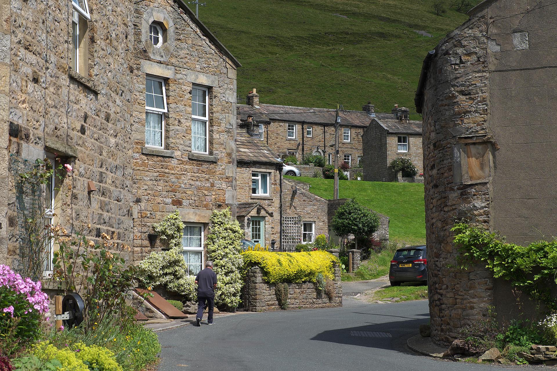
Welcome to the Yorkshire Dales village of Gunnerside. Peaceful, isn’t it? And so pretty! It’s no wonder visitors flock to this beautiful part of Britain.
But look around at the attractive limestone cottages; many of these were once the homes of miners and their families. It may not look like a typical mining landscape, but all that will soon change as we follow the trail out of the village and up a side valley known as Gunnerside Gill.
As we head higher into the gill, it becomes impossible to miss the scars left behind by lead mining, one of the activities that helped Britain become the industrial powerhouse of the world. Taking in the beautiful Swaledale scenery as you go, this walk combines stunning landscapes with a deadly story...
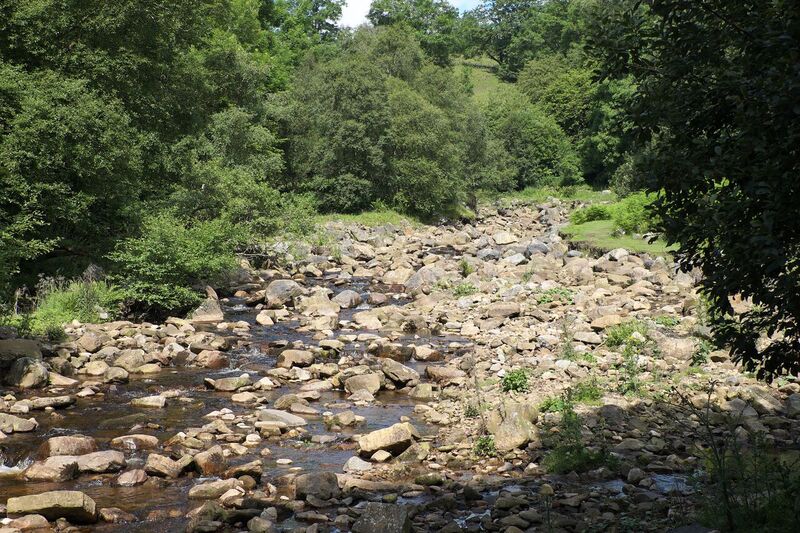
From the parking area, walk across the road bridge and immediately turn left along the rough track beside the stream. Just before a gate, climb the steps on the right. After the next gate, bear left to head up into the valley on a faint path. This goes through a small gate into an area of woodland. After emerging from the trees, stop to take in your surroundings.
2 Beck and woodland
There are still few signs of the lead industry, but this tranquil section of Gunnerside Gill gives us some clues as to why the area came to be so closely linked with lead mining.
First of all though, we need to understand some of the local terms for landscape, or topographical, features. The little valley we’re in is a ‘gill’, which comes from the Norse word ‘gil’, meaning ravine or gully. The stream running through a gill is a beck, from the Norse ‘bekkr’. This one along side us is Gunnerside Beck. Look at any map of the Yorkshire Dales or the Lake District, and you’ll find more Norse words. Examples include ‘foss’ or ‘force’ for waterfalls and ‘fell’ from ‘fjell’ meaning hill or mountain. Even the word ‘dale’, meaning valley, originates from an old Norse word, ‘dalr’. Norse people first settled in these uplands more than 1,100 years ago.
But what about those lead mining clues? Well, the most important is the stream to your left. Gunnerside Beck is fed by dozens of smaller streams flowing off the damp moorland to the north. When lead mining was at its peak, its water would’ve been absolutely crucial – for exposing mineral veins; for separating the rock, or ore, containing the lead from other rocks and waste material; and for powering pumps, bellows and other equipment.
You’re also surrounded by another important material used in the lead industry – wood. Although, as we’ll see later, wood wasn’t the only fuel used, trees along the valley sides would’ve been felled to fire up the furnaces of the smelting mills. (This is where the lead metal was extracted from its ore by heating and melting.) More recently, attempts have been made to regenerate the woodland you can see on the other side of the beck. Fences were put up to stop livestock getting at the trees and native species such as rowan, birch and hawthorn have been planted.
The trail goes through a tiny gate and up some steps to re-enter the woods. The path is rough in places now, with exposed tree roots and lumps of rock waiting to trip up the unwary, so watch your footing. After crossing a tiny wooden footbridge, you leave the woods via a gap in a wall. Go through a gated stile in the wall on the right and turn left to walk through the meadow with a wall and then a fence on your left. You’ll pass through another gap in an intervening wall and then through a gate in the wall on the left. Waymarkers now guide you through the mine workings. Stop when you reach the ruined buildings.
3 Dressing floor
Finally we can see the first substantial remains of the industry that played such a key role in Swaledale’s history. We’re now standing on what’s known as a dressing floor. Do you see those open-sided stone chambers up to the right? They’re known as bouse teams and that’s where the mined material was stored before being ‘dressed’. In this process, women and boys, some aged as young as nine, separated the valuable ore from the worthless waste. It was a very labour-intensive task and that’s one of the reasons why the mine owners used women and children – they were cheaper than men.
Imagine how busy, noisy and dusty this place must’ve been! Dozens of people would’ve been toiling away beside the beck, smashing up the rocks by hand and sifting through it for the precious ores of lead. It was a very demanding physical process and the noxious lead would probably have poisoned many of those working here in one way or another. Lead poisoning is associated with abdominal problems, learning difficulties in children, memory loss, kidney disease, high blood pressure, reproductive issues and problems relating to the central nervous system.
So, why did our ancestors go to such great lengths to produce lead? Well, the metal had been used for millennia – lead glazes feature on prehistoric pottery, lead waterpipes were common throughout the Roman Empire and the regular use of skin whitener containing lead is thought to have killed Elizabeth I. It doesn’t corrode, it’s easy to work and smelting its ore, known as galena, is relatively straightforward.
During the Industrial Revolution, the lead mines of northern England were the busiest in the world; this important metal was being plundered from the hills to roof, plumb and paint the homes of our rapidly expanding towns and cities. It continues to be used today, including in the batteries that start our cars.
Continue beside the beck and then cross a stile in a fence. The path climbs through the bracken and then runs beside a wall. Cross another stile and walk along the top of a steep, stony embankment. The path is narrow here, so keep back from the edge. After going through a gap in the wall on the right, climb the eastern side of the valley on the now grassy path. As the gradient eases, you’ll encounter a wall on the left. Stop to catch your breath.
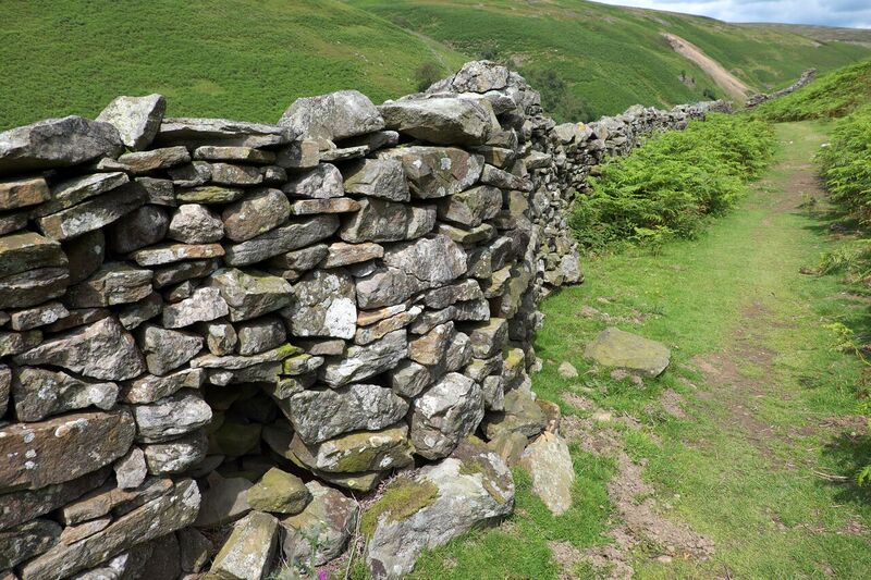
4 Drystone wall
This is a lovely path, isn’t it? There’s grass underfoot, the gradient’s easing off and the steep-sided valley is truly beautiful here. In spring and summer, listen for the bubbling trill of the curlew or the ecstatic song of the skylark. It’s different in winter though – when the heavy rain, the storms and the snow all set in.
But why would you want to go for a stroll up Gunnerside Gill in such conditions? If you’d worked in the lead industry in the nineteenth century, you wouldn’t have had a choice. With most of the workings further up the valley, many miners and other workers would’ve trudged this path on a daily basis, come rain, snow or shine. Depending on exactly where they worked, this would’ve involved a round trip of up to eight miles.
For most families, the money they earned from the lead industry wouldn’t have been enough to live on. Many also ran smallholdings, providing them with food and extra income from making butter, cured meats and woollen products. Knitting would’ve been a skill that men, women and children learned as a survival tool – not as a pastime.
Imagine that! You’ve had to hike four miles to get to work, knitting while you walked; you’ve toiled for 10 hours in the mine workings; you’ve trudged another four miles home, knitting again; and then you’re faced with farm chores – milking the cow, feeding the pigs, mending walls...
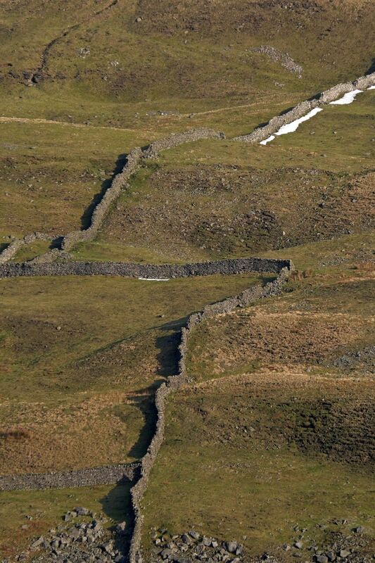
Walls like the one on your left. Have a look at it. It’s a dry stone wall, which means there’s no mortar holding it together; it’s cleverly built from nothing but stones. This wall, like others in the valley, may well have been built, or at least maintained, by a miner to contain his precious livestock.
Reaching a pile of rocks (or cairn), another path joins from the right. You later ford a tiny stream to enter another area of ruined mine buildings. Stop as you draw level with an arched mine entrance on your right.
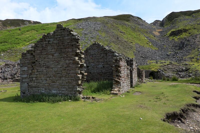
5 Bunton ore works
Do you remember how pretty the village of Gunnerside was? It seemed hard to believe we were on the edge of a lead mining area. Now, as the valley around us narrows, the scars of that industry stare us in the face. We’re standing in a place of utter desolation.
Look towards the beck. The steep slopes leading down there are composed almost entirely of rubble and spoil from the workings. Look up at the shattered moonscape on the hillside above. That’s part of the Bunton ‘hush’ – where water would’ve been used to enable open-cast mining.
As in most hushes, this one involved an entirely man-made water course, although a few hushes would’ve followed the lines of existing, natural streams. In either case, a dam would’ve been built at the top of the slope and water released – either to expose the ore vein or to wash away debris as miners went to work with pick and shovel. The water’s gone now, but the exposed bedrock remains. There are hushes on the other side of the valley too – those rocky ravines that cut into the hillside aren’t the result of natural processes.
Nature is reclaiming some of the remains, but it’s a slow process. The arched mine entrance to your right, known as an adit, has mosses and ferns growing from it; it’s starting to blend into the landscape. The building directly in front of you – the mineshop where some miners would’ve lodged during the week – is really no different to the ruined shepherds’ huts or barns scattered throughout the hills of Britain.
But what about the hushes and the spoil heaps, still largely devoid of vegetation? It’s already 130 years since the Bunton area was worked, but the scars left on the landscape are still obvious
So why did these mines stop working? It was mainly due to cheap imports, particularly from Spain and the United States, towards the end of the nineteenth century; Britain’s lead mines simply couldn’t compete. In Gunnerside, the workings we passed earlier on the trail, were the last to close – in 1906.
Beyond the Bunton workings, continue uphill to a fingerpost and a cairn in a rocky area. Immediately after the cairn, the trail forks. Bear left here, heading downhill on loose ground. When the trail drops to Gunnerside Beck, simply follow it upstream. Stop as soon as you reach the next set of buildings.
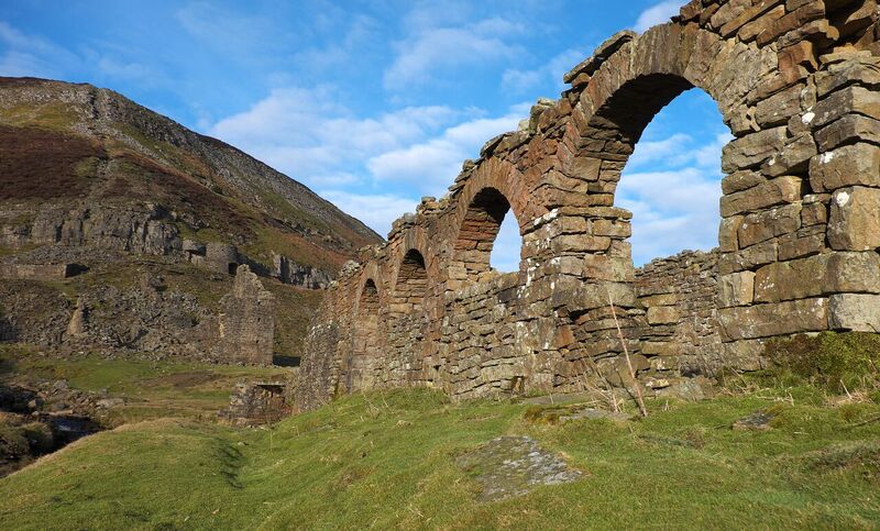
6 Blakethwaite Smelt Mill
Built just before Queen Victoria came to the throne, these ruins once formed part of a smelting mill, where the lead metal was extracted from its ore. The building directly in front of you was a peat store. This material, dug by hand from the moorland high above, was used to heat up ore pellets in the larger building on the opposite side of the gill so the molten lead could be drained from it. The waters of the beck, controlled by a dam higher up, would’ve played a part in this process, powering a wheel that drove the bellows.
Today though, the beck flows more naturally past the ruins, forming a small pool just below the footbridge. In summer, walkers on the Coast to Coast long-distance path stop here to have lunch and cool their tired feet in the peat-laden waters.
Looking up the steep slope on the other side of the gill, you’ll see a crumbling line of rubble heading straight up to the skyline. It looks like a collapsed tunnel, and that’s almost exactly what it is – the remains of a flue that carried some of the poisonous fumes from the smelter into the sky above. Believe it or not, small boys used to be sent up flues like this to scrape condensed lead from its toxic walls.
Despite the harsh realities of life for the people who once worked here, there is something romantic about the scene. Don’t you think the arches in the west wall of the peat store, for instance, give the location an almost ecclesiastical feel? Visit on a sunny summer’s day and you won’t be able to resist the urge to linger here, to take photographs, get a picnic out... We’re being given a glimpse into past lives while nature slowly, very slowly, regains its hold on this shattered landscape.
Retrace your steps to Gunnerside village. Remember to keep right after following the loose trail up from Gunnerside Beck. Then, beyond the Bunton workings, bear right when the path forks at the cairn. After descending back to the valley floor, it’s simply a case of following the beck downstream. There is one place where you could go wrong though: in the first patch of woodland, just after a fingerpost with ‘woodland trail’ on it, be careful not to miss the steps down to your right.
Your browser is out of date, and unsupported by this website. Please upgrade to the latest version to use this website.
A short walk up Gunnerside Gill in the Yorkshire Dales
The pretty village of Gunnerside lies close to the northern edge of the Yorkshire Dales. It’s part of Swaledale, one of the most popular valleys in the National Park, renowned for its idyllic riverside meadows and distinctive stone barns. But it’s not always been so peaceful...
This trail, heading up into the side valley of Gunnerside Gill, explores the area’s lead mining history, including how local people were involved in the poisonous processes, and looks at the legacy left behind by this once-deadly industry.
Follow the trail by clicking on the map pins or downloading the guide below
Writer and photographerVivienne Crowfor writing and photographing the trail. Vivienne is the author of a number of walking guides and a regular contributor to several magazines and newspapers.
"The smelting-mill stack is crumbling, no smoke is alive there Down in the valley the furnace no lead-ore of worth burns New tombs of decaying industry, not to survive here..." W H Auden


 During the Industrial Revolution, the lead mines of northern England were the busiest in the world; this important metal was being plundered from the hills to roof, plumb and paint the homes of our rapidly expanding towns and cities. It continues to be used today, including in the batteries that start our cars.