Welcome to this walk in Warwick. My name is Martin Haslett. I am a town planner who has worked in Warwick for over 20 years, helping to conserve and protect this lovely old town. In doing this job, I’ve learned a lot about its history and development.
This walk will share some of Warwick's stories with you. We will discover the early origins of the town and how the Castle played such an important part in Warwick’s history. Over time, as defence became less important, the Castle developed a new role as a country house and Warwick became the county town and a centre for trade and commerce.
The walk route passes many of the main sights and you might like to visit them afterwards. The route is about three-and-a-half miles long and should take around a couple of hours at a medium pace. It is in the town centre and includes crossing several busy roads, so please take care.
From St Nicholas Park, make your way to the gates at Banbury Road. Cross over using the pelican crossing and turn left. When you reach the bridge over the river, stop to look at the view of the Castle.
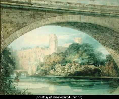
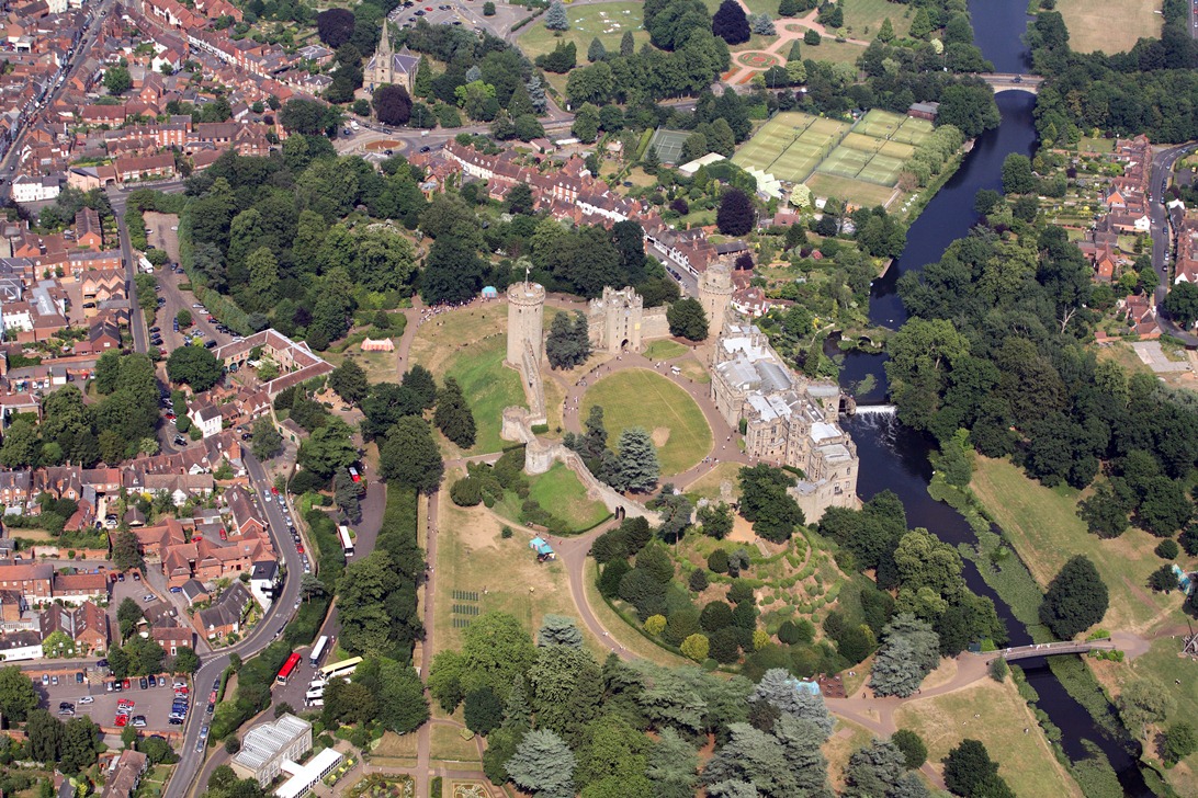
2 The finest view in England!
It’s appropriate that we start with Warwick Castle because the establishment of this defensive position was the beginning of our story of Warwick’s thousand-year history.
You can see why this site was chosen for the Castle. From here it was easy to control the crossing point of the river and, being situated on slightly higher land, there was a commanding view of the surrounding land.
Queen Elthelfreda (daughter of Alfred the Great) fortified the hill in the year 914 to defend it against the Danes. By the time of the Norman Conquest in 1066 Warwick was a small town. William the Conqueror built a motte and bailey castle here in 1068 as part of his plan to control his newly-acquired kingdom. By the time of the Domesday survey in 1086 Warwick consisted of 244 houses.
Of course the castle that you see today has been built over many centuries. The Norman Castle was of earth and wood and it was not until the twelfth century that stone was used. Much of what you see from this viewpoint is fourteenth century in origin, including the two prominent towers, Caesar’s Tower and Guy’s Tower.
In the centuries since, there have been a series of additions and repairs to the castle. There was also a serious fire in Victorian times which resulted in much restoration.
This view from the bridge has been described as ‘the finest view in England’ and you can understand why. The Castle deserves a full day visit in itself....but we must be moving on!
If you look carefully at the river in front of the castle, you will see the remains of an old bridge. This will be significant to our next stop.
Continue over the bridge. At the roundabout, turn tight and go down Bridge End. Follow the road to for about 250 metres. Stop where it bends to the left.
3 A road with no bridge!
This road is called Bridge End. At this point two roads converged to go over the old bridge. The old bridge once carried the main road into Warwick and it would have been a bustling centre of activity instead of the quiet backwater that we find today.
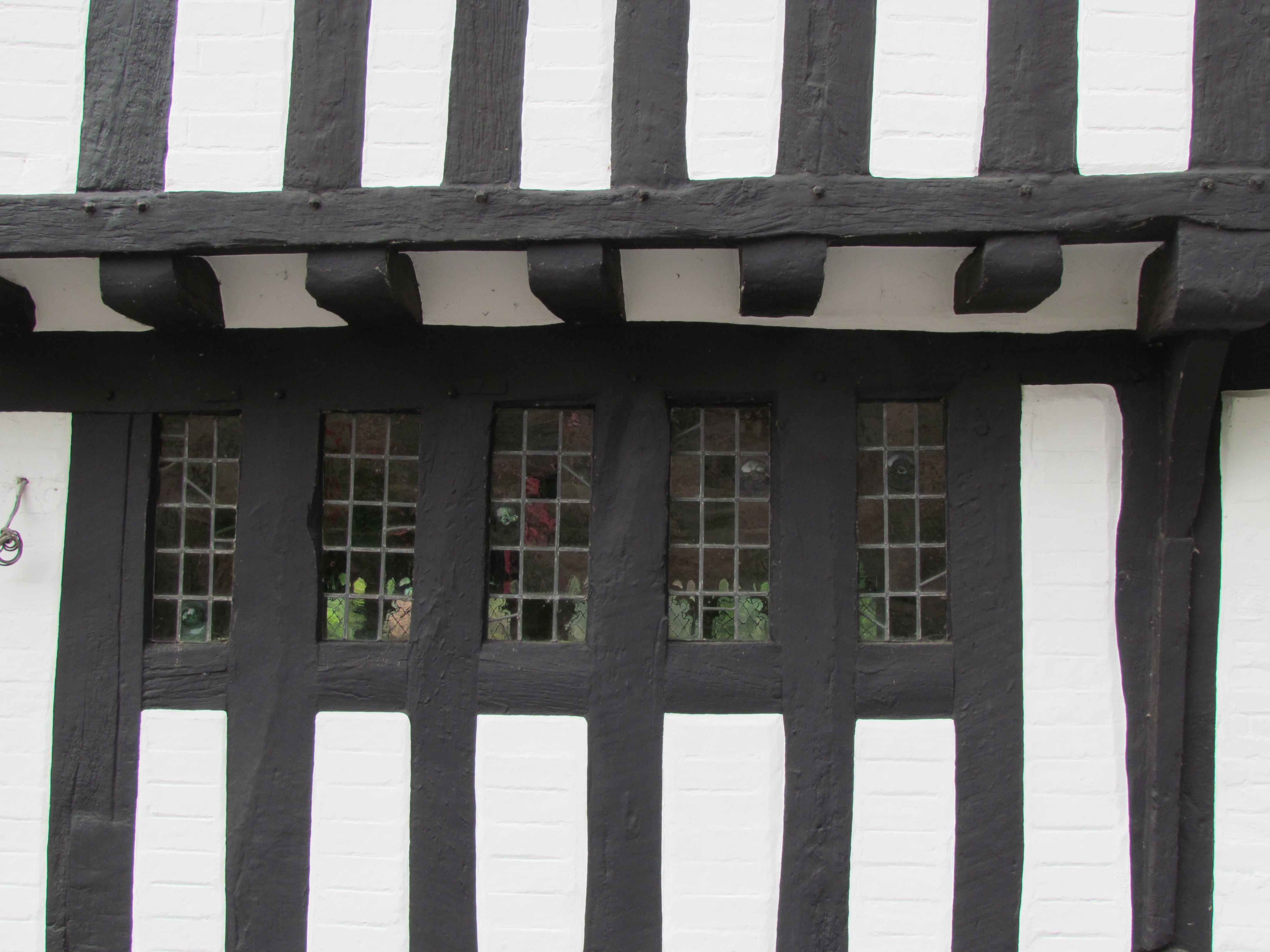
Here we are in a medieval suburb of the walled town, which has been isolated from the rest of Warwick for over 200 years since the old bridge was closed. Have a look at the timber-framed buildings. This road gives a good impression of what a medieval street would have been like.
With the road leading to the old bridge there would also have been a clear view of the Castle. Apart from the view from the new bridge the castle is largely hidden from the town today.
Remains of the old bridge from the castle By kind permission of www.enjoywarwickshire.com
Directions
When you are ready, retrace your steps back over the bridge. Continue up Banbury Road to the roundabout. Ahead of you is the Castle gateway. Turn left down Mill Street. Walk down to the end of Mill Street under the castle walls.
4 A fine medieval street
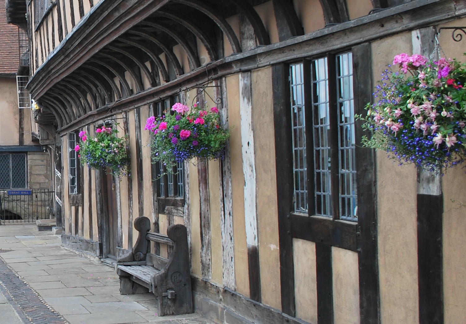
This is Mill Street. Mill Street is the other end of the old bridge that we saw at our previous stop. It is also another medieval suburb of the town and would once have been a busy main road.
Here we have a very clear impression of a medieval street, as most of the buildings have been preserved. Most of the buildings in the street date back to the fifteenth and sixteenth centuries. Many of them are fine houses and would have been occupied by the well-off...and their servants.
At the end of the street is an impressive view of the castle. The final house has a garden, often open to the public, which gives wonderful views of the Castle and the river.
Retrace your steps back up Mill Street. Stop in front of the castle gateway.
5 The ruins restored
As defence became less important, the Castle became a country house occupied by successive ‘Earls of Warwick’. It was the Greville family, the current holders of the title who took over the Castle in 1604 and transformed it from a ruinous fortress to a stately home.
Aristocrats travelled around by horse and carriage, so once the castle became a country house, it was necessary to construct a carriage entrance to it and this is what we see here. As we walk up the drive, imagine visitors arriving along this rather impressive driveway, cut through the sandstone.
It’s worth noting that we will see other examples of roads cutting through the stone. It looks very atmospheric, but the soft nature of the local stone has caused many a headache in conserving buildings in the town, including the Castle. All the local quarries are now closed, so the best match for repairs has to be found from sandstones located in other parts of the country.
From the wrought iron gates at the top of the drive there is a good view of the interior of the castle grounds. A little further on, the ticketing offices for the castle are in the former stables, where the Earl’s horses and carriages would have been kept.
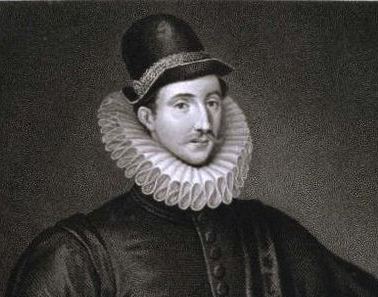
Lord Brooke by Edmund Lodge (1620) Wikimedia Commons
Directions
Go through the Castle gateway and follow the driveway. At the gates you can stop to see inside the castle. Go up the steps to the right of the gates. Continue along here with the castle entrance on the left and a car part on the right. When you reach Castle Lane, turn left. Stop at the end where it meets Castle Street.
Step-free directions – Facing the Castle gateway take the road to the right, which is Castle Hill, keeping the castle walls on the left. Then take the first turning left into Castle Lane. Go to the end where it meets Castle Street.
6 A civic bargain
Stand facing 24 Castle Street, at the junction of Castle Lane and Castle Street. If you look to the right from here we have our first glimpse of the centre of the town including some more timber-framed buildings.
The timber-framed building that is now a tea shop belonged to Thomas Oken. He was a silk merchant who died childless in 1573. His money was used to establish an almshouse and to pay for a school master.
Looking left you can see a cobbled slope leading down to the castle wall. This was the original road that led once down past the Castle Stables to meet Mill Street by the old bridge. But Castle Street is now cut off by the castle wall. This is a result of the Earl of Warwick’s extension to his grounds, which was carried out in 1789.
By this date the old bridge was judged to be unsafe and the Earl struck a bargain with the town – he would pay for three quarters of the cost of the new bridge (where we stood at the beginning of this walk) in return for being allowed to extend the grounds of the castle from the old bridge to the new one. This was only just in time, as a few years later, parts of the old bridge were swept away in a flood.
You can visit a small part of the grounds when you visit the Castle, but the major part is in private ownership and not open to the public – which is a great shame, not least because they were laid out by the famous landscape architect, Capability Brown.
We are not going into the centre just yet because this would take us to a completely different phase of Warwick’s history and I want us to continue in the medieval era for now.
Turn left and follow Castle Road around, keeping the castle walls on your left. At King’s Lodge, turn right into Leycester Place. At the end, turn right up the hill. Cross over the traffic island. Take care as this can be a busy road. Make your way back down the hill towards the Westgate tower. Stop when you are beneath the tower.
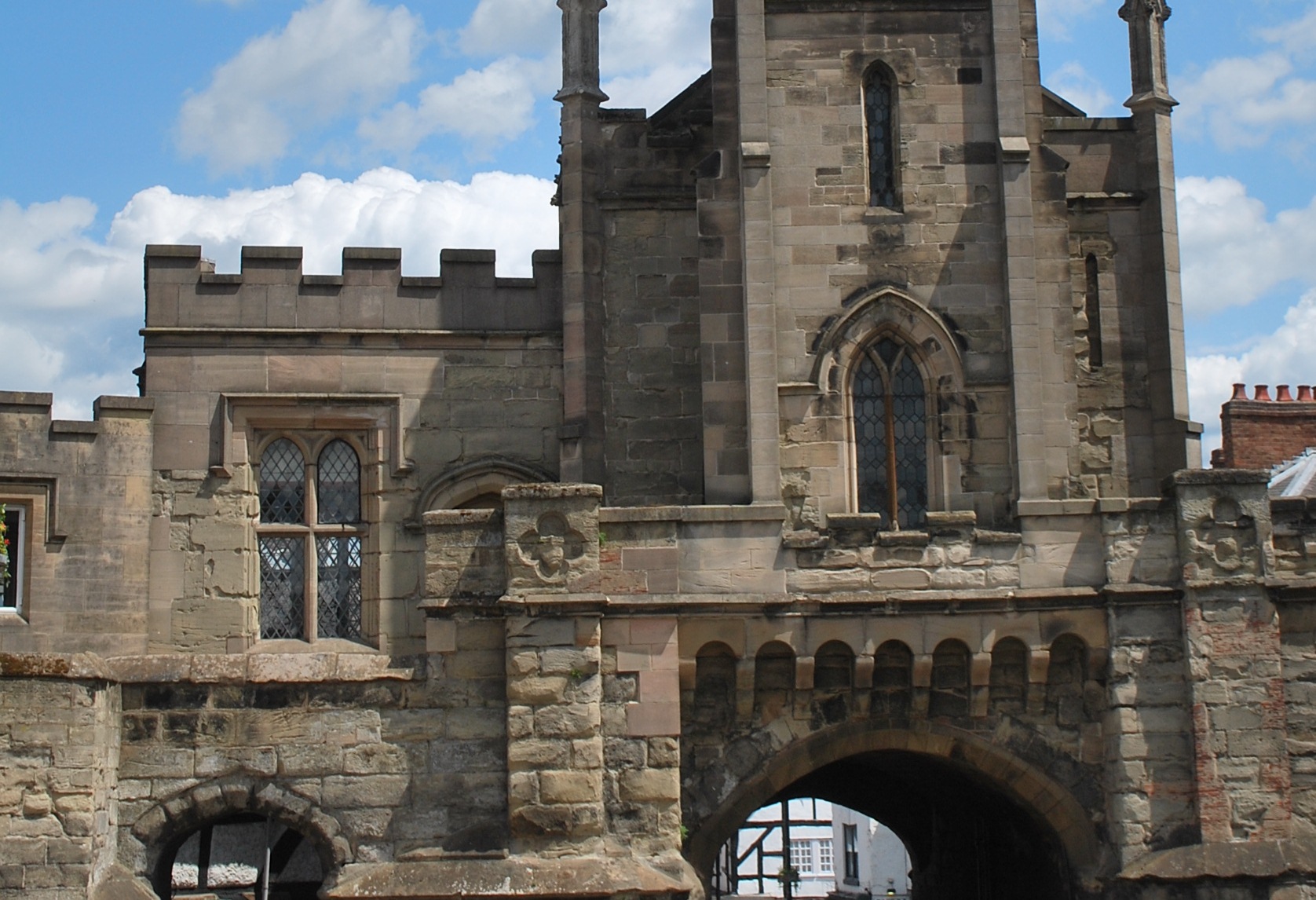
7 Medieval gates
In the medieval era many towns had gates, which would have been closed at night. Warwick is fortunate to have retained two of its medieval gates – Westgate and Eastgate. There was a north gate, but never a south gate as this area was defended by the Castle.
The comparatively steep slope up from West Street emphasises the hill-top position of the town. Westgate was considerably altered as a result of ‘restoration’ in 1863 but we still have a clear idea of a medieval town gate and the oldest parts of the structure date back to the thirteenth century.
The original route of the road was through the gate and we can see again how the roadway, wide enough for a horse and cart, was cut through the natural stone. Looking back down West Street, we can see some timber-framed buildings and from these it is clear that there was a suburb of considerable size outside of the walls.
Facing the Gate, from the lower side, look just to the left where we can see the best-preserved sections of the town wall. These parts have been preserved as they support the garden of our next stopping point. Inside the gate
As we go through the gate, we can see just how soft the local sandstone is. Look for the mason’s chisel marks on the harder stone higher up. Also note the early pillar box to the right. It was cast in the form of a Doric column in 1856.
Go up through Westgate. Take your time to look at the stonework. At the top of the slope, turn back on yourself into the cobbled area outside the Lord Leycester Hospital. Go through the stone arch and stop here.
8 A grand home for retired servicemen
Just on the town side of Westgate is the Lord Leycester Hospital. After the Castle this is the most important relic of medieval Warwick.
The hospital was established by the Earl of Leicester in 1571 as a home for retired army servicemen, although the buildings, which belonged to two Guilds, date from the late fifteenth century. It’s another building that is worth a dedicated visit but it’s possible to go round much of the exterior without paying to go inside.
You can also see the rear of the building from Puckerings Lane. Some parts of the building are still used as homes for retired servicemen and these are, of course, private.
Apart from the inside of the hospital, there is a garden which is open to the public and an excellent tea room where you might like to stop for lunch.
Retrace your steps back down through Westgate then turn right into Bowling Green Street. Cross the road at the pedestrian crossing opposite the school. Turn left into Hill Close Gardens at the side of the school. A sign says private property but this is actually a public right of way. Walk past the garages and stop at the railings at the far end overlooking Hill Close Gardens. Feel free to visit the garden afterwards by going down the steps on the left and following the path.
9 Green fingers
Though we are trying to keep the walk chronological there is a big jump forwards in time for this stop but we have to see it now otherwise we will miss it!
Hill Close Gardens is a group of Victorian gardens purposely created as a recreation area for the inhabitants and tradesmen of the town, who generally lived in cottages and houses that did not have gardens. There must have been many similar examples in other towns which have now been lost – and these ones in Warwick were very nearly lost too!
The Council had bought the land for housing, but a group of local enthusiasts managed to persuade them to donate the land to a trust – and forego the value of the land as a development site. Apart from several very old varieties of apple trees, these gardens are particularly important because several ‘summerhouses’ remained. Although in poor repair, these have now been restored.
One of the restored summerhouses is immediately below. The summerhouses were for the gardener to shelter whilst having a break, but were also fitted out with sitting rooms and furniture, so that all the family could enjoy the garden. The Gardens are another site well worth spending time at. The main entrance is off Bread and Meat Close.
As we stand here we can glimpse the Racecourse, beyond the gardens. The racecourse and the common land on which it is situated has been another important factor restricting the growth of Warwick. From this point, virtually in the town centre, we can look out to open countryside.
When you are ready, retrace your steps through the car park and back onto Bowling Green Street. Turn left and cross over at the pedestrian crossing. Follow the road that sweeps to the left to Market Place. Once in the Market Square, stop outside the Market Hall.
10 Fire!
Here at the Market Hall, we are out of medieval Warwick and into a newer townscape. We are on the edge of the area devastated by the Great Fire of 1694. This is the next great influence on the appearance of Warwick as we see it today, and the reason why we have skirted round the town centre.
The fire started on the south side of the High Street and the south westerly wind spread the flames through the town centre. It had been a long, hot summer and the timber-framed and thatched houses burned easily.
As the blaze quickly spreading across the narrow streets, some buildings were torn down to try to stop the fire’s advance. A few buildings in the town centre did survive, often as a result of determined efforts by the townsfolk, and we shall see some of these later.
The Market Hall (now the County Museum) was built in 1680 and originally had open sides. It’s free and another place well worth a visit.
The east side of Market Place was rebuilt after the fire and introduces to us a new phase of the town’s history. Our next few stops are going to explore the rebuilding of the town after the fire.
Walk up Market Place with The Tilted Wig pub on the right. At the top, turn right. Stop outside the church.
11 Relief and rebuilding
The Great Fire consumed the tower, nave, aisles and transepts of the old church, which dated back to Norman times. The only surviving Norman part is the crypt and this you can visit. Another very important but later survival is the Beauchamp Chapel of 1442-63.
Much of the rest of the church dates from the post-fire rebuilding. In 1694 Warwick had a population of just 3,000 and the task of rebuilding the church was daunting. First, there was the need to help people who had lost everything. A relief committee headed by Lord Brooke (from the Castle) was set up and churches throughout England contributed. For the rebuilding of St Mary’s the town contributed £11,000 and the reigning monarch, Queen Anne, gave £1,000.
Lord Brook was familiar with Christopher Wren’s reconstruction of London after the Great Fire and so he wanted Warwick to learn from this example. An Act of 1694 empowered a group of local gentry to be Fire Commissioners, and to plan the rebuilding of the town.
Look at the small square in front of the church – Old Square. The design was influenced by the square in front of St Paul’s Cathedral although the effect here is reduced by the fact that the tower had to be built jutting out into the square.
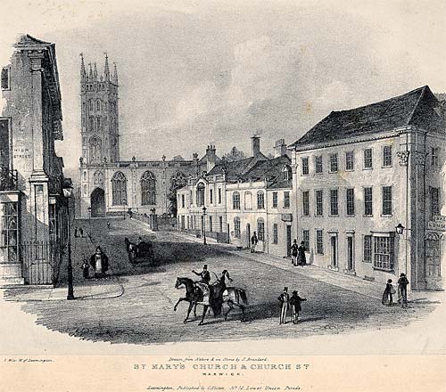
Before we leave this spot have a look down Church Street. This is a good example of the post-fire reconstruction of the town – wide streets and houses generally limited to two storeys with dormer windows above. Also look the other way along Northgate. Northgate is the best example of the post-fire rebuilding and is, perhaps, the grandest street in Warwick.
St Mary's Church and Church Street (c.1840) Leamington Spa Art Gallery & Museum
Directions
From the church, walk along Northgate Street. At the end of the street, stop before the small roundabout.
12 A new set of rules
Look across the roundabout at the house with the blue doors. Northgate House marks the site of the third gate into the town and is a fine example of a post-fire town house of 1698.
The Fire Commissioners decreed that roads were to be widened and straightened, houses would be only two storeys (plus attic), and each storey was to be ten feet in height. The small dormer windows in the roof are a typical feature of post-fire Warwick.
Three storey buildings were allowed only in special circumstances, such as at junctions. Building materials were to be brick or stone, with tiled roofs. Between terraced houses there were to be fire-break wall 18 inches thick at the base and 8 inches at the top. This was a very strict building code.
All this was all done to decrease the risk of fire, but equally giving us a rather well-planned town and a rare example of what is known as William and Mary and Queen Anne town planning.
Cross over safely to Northgate House and turn left down Saltisford. At the next roundabout, keep right on the main road. When you reach the Black Horse Inn, turn right into Victoria Street.
13 We could be in Birmingham!
Unlike many English towns, Warwick expanded rather slowly in Victorian times. Some industries did come to the town, notably metal castings and gelatine manufacture, but the population expanded comparatively little – from 5,600 in 1801 to 11,000 in 1851 and 12,000 in 1901. (Today it is about 24,000).
What’s more, the main industrial areas were along the canal – now the Grand Union Canal – and well away from the town centre. Nevertheless, as we can see from those census figures, there was some expansion of population.
One of the main sites for the new housing was in this area. The street names – Victoria Street and Albert Street – pay homage to the popular queen and her consort. These were respectable houses for reasonably well-off residents.
They were built on small plots to allow a large number of houses in relation to the road frontage. Nevertheless, these streets must have been very strange to Warwick residents of the time - although they would not look out of place in Birmingham whose suburbs were expanding at this time.
Go back to the Black Horse Inn and turn right along Saltisford. Don’t forget to look up Albert Street, which is the next road on the right. Continue a short way further until you reach a large building opposite The Antelope pub.
14 Illumination
The Victorian era brought many changes to our towns including lighting for streets and for homes. This lighting was powered by gas and until comparatively recently gas was produced by burning coal.
This is the remains of the original Warwick gasworks – one of the best-preserved original gasworks in the world. Two gasholders have survived – or rather the octagonal buildings which were erected to retain the gas tanks. Whether this was a good design is rather doubtful – in the event of an explosion, the bricks would have been thrown far and wide!
The gas company had its offices in the central section, which was originally single storey. The gas was produced to the rear of the gasholders and resulted in considerable pollution of the soil, which remains to this day. Coal was brought in by canal, which is now a little further down the road, but a canal arm used to come up towards the gasworks.
Continue along the road. Shortly after a junction with traffic lights, you will reach a small stone building.
15 A home for outcasts
There had been leprosy in England since at least Roman times but numbers were probably increased by men returning from the Crusades in the Middle Ages. Lepers were complete outcasts: they had to wear distinctive clothing and were forced to live well outside of the town.
None of these leper colonies has survived intact, but the one at Warwick is the most complete. The first records of the hospital date back to the twelfth century and the buildings continued in this use until the sixteenth century when leprosy seems to have finally died out in England. Afterwards the buildings, including the chapel, were converted into cottages.
The chapel at the front was restored in 1993 and was where the lepers worshipped. To the rear, in bad condition at time this walk was prepared, is a timber-framed building which was the Master’s House. This was the home of the man who looked after the lepers, probably a priest.
Care for the lepers was more spiritual than medical. It was not until the nineteenth century that the disease was fully understood and could be treated.
Retrace your steps back into town, past the gas works and up the hill to Northgate House. Turn down Cape Road at the side of Northgate House. Cross over and enter Priory Park by the signboard. Walk fairly straight into the park through the trees and stop on the flat grassy area.
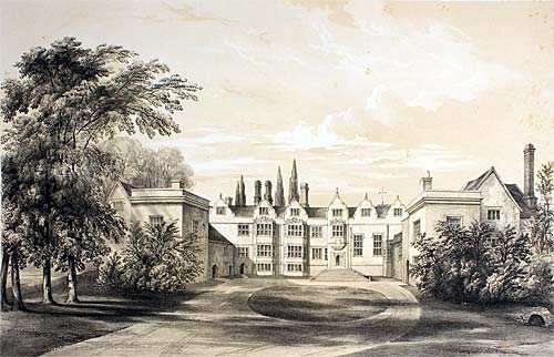
16 A little piece of Warwick in the USA
This is the site of the Priory. Although little remains, it has exerted a considerable influence on the urban morphology of Warwick.
A monastery was founded in the twelfth century. After Henry the Eighth’s dissolution of the monasteries, a Tudor country house was built on the site.
Then in 1926 the building was bought by an American at a ‘demolition sale’ and he dismantled the buildings and much of the structure was exported to America and re-erected in Richmond, Virginia for the Virginia Historical Society.
The dismantling of country houses was not uncommon in that era but is sad to think that such an historic monument has been lost to the town. It was not entirely lost, however, as the grounds still remain as Priory Park. The existence of the house and grounds caused Victorian and later development to leapfrog the site and to leave this large area of open space so close to the town centre undeveloped.
The flat grassy area was probably one of the garden terraces. Over the trees you may also see buildings that were part of the priory. But other than that, it was moved in its entirety to America!
Warwick Priory Leamington Spa Art Gallery & Museum
Directions
Retrace your steps out of the park the way that you came in. At the top of Cape Road cross over and turn left. Take the road down the right hand side of the Punch Bowl pub. After passing a car park on the right look for the entrance to an alleyway between high walls.
17 The path with a strange name
The pathway starts out behind high walls on either side and this is said to be how it got it strange name of Tink-a-Tank from the sound of boots echoing on the walls.
As we proceed along the path there is a good view of the back of St Mary’s Church (which we saw from the front earlier) and its two prominent east windows. The smaller one to the left is the window of the Beauchamp Chapel, the principal surviving part of the medieval church. It said that fire fighters were only able to stop the fire at the door to the chapel.
It’s interesting to note how the ‘new’ building of the church has incorporated the ancient chapel, which, from the outside looks contemporary with the rest of the building
Continue along the alley and the back of St Mary’s Church until you reach Church Street. Turn left into Church Street and go down to the crossroads with Jury Street.
18 An exception to the rule
At last we are officially in the town centre at the cross-roads of the old town. In medieval times there was a High Cross here at the junction of roads from Eastgate, Westgate, the church and the road from the old bridge over the River Avon.
Looking along the three main roads from here this is a good place to practice distinguishing pre - and post-fire development in Warwick.
The junction of these four streets was a special exception included in the post-fire building code – here each building on the junction was allowed to be three stories in height. To add dignity to the junction the corners are each, in turn, decorated with Ionic, Doric and Corinthian columns.
The fourth corner of the cross roads is occupied by the Court House which is now the Visitor Information Centre and Warwickshire Yeomanry Museum. This was built in 1725 replacing a tavern which had survived the fire and explains why the decorative detailing on the other buildings was not carried onto the fourth corner.
Turn left down Jury Street and continue to the end. Cross over to the East Gate in front of you. Stop by the pillar box.
19 A private house with battlements
From Eastgate there is a clear view of the rising land, which has its summit at the cross roads we have just left. Eastgate has a history not dissimilar to West Gate. Its origins are medieval – it was built before 1426 - but extensive restoration was carried out 1788.
Like Westgate, it always had a chapel on top of it, but the one we see now results from the restoration after the fire. The gate is now a private house, having for many years been part of the adjoining girls’ school. There are battlements which give a fine view down Jury Street – not bad for a private house!
There is also another one of the old pillar boxes near the junction with The Butts.
As we pass down Smith Street, we will quickly see how this, like West Street, was another medieval suburb of the town. Look out for the timber-framed buildings to confirm this. It is probable that there are several more re-fronted in brick to look more ‘modern.’ Also, like West Street, it is downhill all the way, clearly demonstrating Warwick’s defensive site marked out by Ethelfreda over a thousand years ago.
Go through the Eastgate and continue down Smith Street. At the bottom, cross to the right hand side using the two pedestrian crossings. Continue along the right hand side of St John’s with a stone wall on your right. Stop when you reach the gates of St John’s House – go in if they are open.
20 A fine appearance
Our final stop is to see a very significant building outside of the town walls. St John’s House was built for the Stoughton family, probably in 1626. They were clearly a wealthy family and it’s interesting to note just how much the town had outgrown its walls by this date. The building now houses the Royal Regiment of Fusiliers Museum. It’s another place that repays a longer visit.
But here we must end. We have traced the history of Warwick from Saxon times through the medieval period and onwards through the Victorian era to the present. We have seen how geographical influences have made the town what it is today. I hope you will be able to see why Daniel Defoe wrote of Warwick in 1726 “Few towns in England make so fine an appearance.” And that was all thanks to a disastrous fire!
And just one final thought to bring us full circle to where we started... The castle, founded in 1086, is today one of the town’s largest employers. It needs lot of ticketing staff, administrators and cleaners! Another example of how past actions influence the present and the future.
From here, you’re just a short distance from where we started. I do hope you have enjoyed this walk around Warwick and will be able to explore some of the other sights I have mentioned in more depth.
In our towns and cities, attention usually falls upon historic monuments, beautiful architecture or spectacular buildings. But how often do you notice the basics - like roads, bridges, paths, walls, houses and gardens?
This walk in Warwick explores famous landmarks and lesser-known corners to uncover the things easily missed.
See how this picturesque town has developed for 1,100 years. Look for modern streets in a medieval layout. Spot changes in housing styles and materials. Find out the legacy of a dramatic fire.
Follow the walk by clicking on the map pins or downloading the guides below