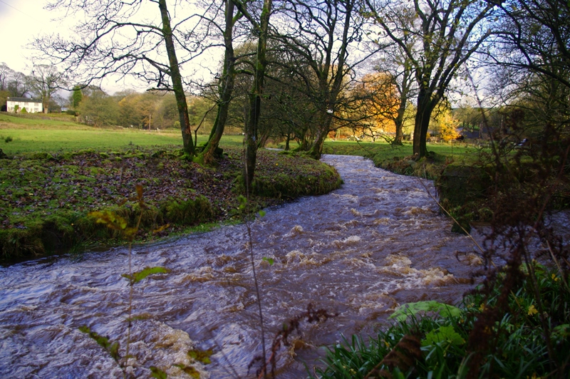
Follow the footpath, just a few metres upstream along the riverbank, through a small grove of trees on the edge of the car park, to reach a confluence of streams.
This is our first meeting with the young River Dane. The river’s source is just three miles away as the crow flies, on Axe Edge Moor. Over those same three miles, half a dozen streams converge and flow into the river. The confluence we can see here, with a stream joining from the right, is a typical example.
At its source on the moor, the River Dane is about 500 metres above sea level. By the time it reaches here, the river has lost almost half of that height. The power gained from this great fall carves through the rock in narrow steep-sided ravines, known in these parts as ‘cloughs’. Typically, they have a ‘V-shape’ profile where the water has eroded through the rock.
Look at an OS map of this area and just around the corner and from the opposite direction you can pick out Robins Clough. Its blue waters plunge rapidly through tightly packed, brown contour lines to meet the Dane.
With all this added flow, it is from this point in its course that the Dane starts to look like something worthy of the title, River. Standing here on the bank you can really sense the kinetic power created from all these watery convergences. This natural source of energy did not go unnoticed by early industrialists, as we shall see at our next stop.
Directions
Walk back through the car park, turning right onto the road. Follow the river downstream. Pass through the entrance to Gradbach Mill and continue along this tarmacked track to the buildings.
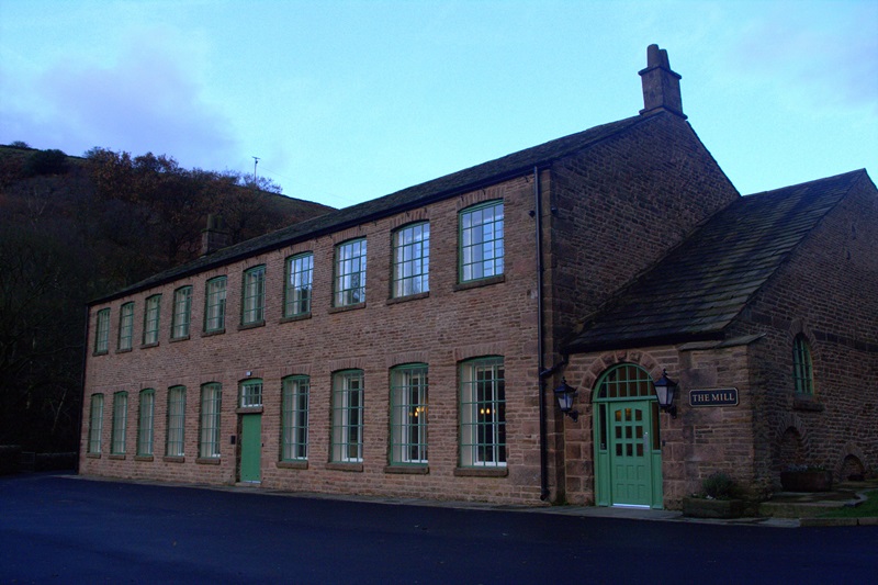
2 Gradbach Mill (SJ 99370 66070)
This impressive mill was constructed in 1785 for spinning silk. No silkworms ever lived around here - the climate is way too cold for them - but silk manufacturing was a well-established industry in this area. The town of Macclesfield, only six miles away, was the big regional centre and a few, even larger eighteenth century mills also survive there.
The raw material was imported from sunny Italy. Though there were no silkworm cocoons hanging from the trees, what this spot did have was all that free power in the tumbling waters of the Dane. The mill harnessed the river’s energy through a gigantic water wheel. This natural water source made the mill cheap to run, but in the end Gradbach was too remote to be commercially viable. It closed in 1885.
Used for a long time as a Youth Hostel, the building is now an education centre for Newcastle-under-Lyme College. It is they who have undertaken the recent restoration work – and what a great job they have made of it!
Before we move on, go and stand on the little footbridge to the side of the main building. From up there we can get a real sense of the power of the river.
Directions
From the mill yard, continue along the public footpath through the mill complex. Follow the path close to the river, past some lush meadows. Go over a stone wall using a stepped stile, then cross a wooden footbridge over a stream. After a few metres, turn right to look back at the stream’s confluence with the river.
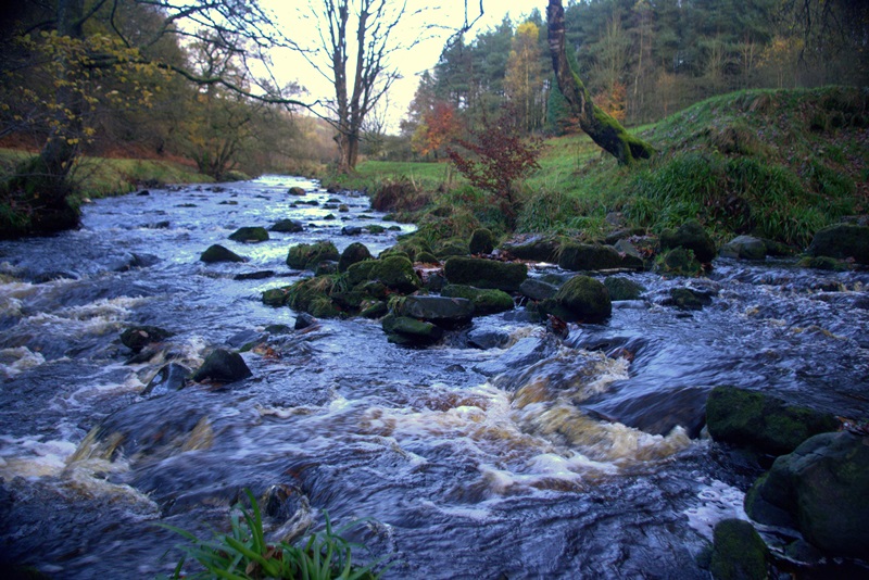
3 The Confluence with Black Brook (SJ 98998 65795)
Here is another major convergence of streams, adding yet more power to the River Dane as it carves its way down towards the Cheshire Plain. This is where Black Brook joins the river. Look in the water and we can see how Black Brook got its name.
If there has been a lot of rainfall, the water may look like strong tea, without milk. This dark brown colour comes from peat staining the water. Peat is found on the high moors where both the River Dane and Black Brook have their origins
Black Brook is fed on one side by water running down from the back of an escarpment called the Roaches. Their name comes from the Norman French word ‘roches’, meaning simply ‘rocks’. There are some dramatic cliffs and spectacular wind-sculpted rock formations up there - well worth exploring another day.
This confluence meanwhile is generally regarded as marking the northern end of the Roaches. From another perspective, this is where the powerful Dane long ago found a thin line of weakness to break through the long ridge of hard rock. So, why wasn’t Gradbach Mill built here, to take advantage of the additional water power of Black Brook?
One answer is that for a good mile downstream there is simply no flat land to build anything bigger than a hut. In fact the Dane Valley narrows so much from this point, it’s not much more than a very deep clough as the river surges on through.
Time now to tackle a bit of an ascent up the north face of the Roaches - don't be alarmed, it is actually a very pleasant walk up through the woods. Along the way look out for beech, oak, pine and birch trees.
Directions
Take the footpath past the huge old beech tree, uphill, following the wooden signs to Lud's Church for a few hundred metres. As the way levels out and you reach a sharp left turn, still signposted to Lud's Church, turn off to the right of the main path to advance on the large outcrop of rocks.
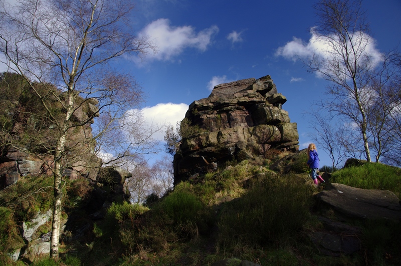
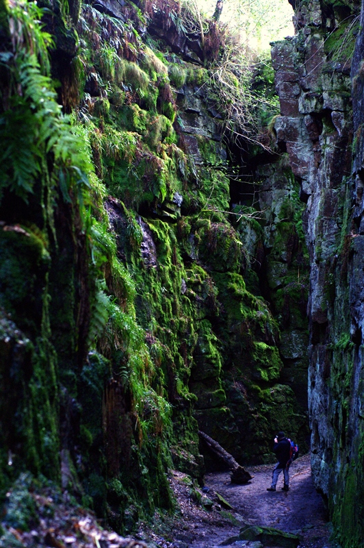
4 Castle Cliff Rocks (SJ 98512 65779)
Castle Cliff Rocks is in effect the last formation of the Roaches, though we are many metres below the heights of the escarpment. A brief clamber on a few of these boulders is fun and will help you appreciate why the Roaches is a mecca for rock climbers. Please do take care here, however, especially in wet or icy weather.
This type of rock doesn’t crumble easily and offers a firm grip. Officially known as Roaches Grit, it is very hard sandstone. It formed from coarse sand washed down into a huge river delta during the late Carboniferous period, some 320 million years ago. This rock is a subdivision of the famous Millstone Grit found widely across the Peak District.
The stack here has survived because this is a particularly hard section of rock. It has withstood the eroding efforts of rain, ice and wind much better than the less durable material which must have once surrounded it.
If you climb carefully up to the furthest boulders, there is a fantastic view back up the valley. The Dane swings away to the left and you should also make out all those little cloughs, with their brooks converging on it from every direction.
Directions
Take the small path for about 100 metres towards Lud's Church as indicated on the signpost. On reaching it, descend very carefully, as the rocks are always slippery.
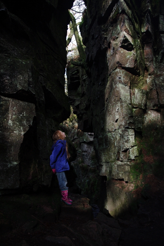
5 Inside Lud's Church (SJ 98701 65644)
Spend a few minutes simply taking in the atmosphere of this incredible place; the mossy walls, the clumps of fern, the absence of direct sunlight. There are hidden niches and side-aisles too, so have a good explore.
It is not hard to imagine that it must have been a centre for pagan worship long before the arrival of Christianity. There are even signs that modern day pagans revere the chasm, from the little offerings you may spot here and there. It is a deeply hidden place.
Lud’s Church is sometimes cited as the inspiration for The Greene Chapel in the medieval poem Sir Gawain and the Green Knight. Read the poem however and the mysterious chapel turns out to be a grassy burial mound well north of the Mersey. It is true, though, that the anonymous author hailed from this region and many evocative local place names, such as Wildboarclough, find echoes in the poem.
Centuries back this was an ideal hideout for those seeking to do secret business away from the prying eyes of authority. Popular folklore has associated many famous fugitives with this place, including Bonnie Prince Charlie and the ubiquitous Robin Hood. One person we know visited here was William de Ludbank. He was arrested here in the fifteenth century and this event most likely gave Lud's Church its name.
William de Ludbank was a Lollard, a religious dissenter. In an era when church services were held in Latin, among other objectives, the Lollards wanted to worship and read the bible in English. This place was almost certainly an improvised and secret church for a group of Lollards. They liked their churches simple and unadorned, so this would have suited them very well.
A century later, after the Reformation took hold and the Church of England was established, holding a mass in Latin became a capital offence. Who knows, perhaps in their turn small congregations of Roman Catholics met here for Latin mass?
One thing is for sure, the sound of voices singing hymns in these echoing depths must have been mesmerising, whatever the denomination. Why not give the acoustics a try for yourself?
Directions
Proceed slowly through the chasm, emerging at the far end along the main path. About half way up the exit route, turn around to take in the view of Lud's Church from this other angle.
6 Lud's Church exit (SJ 98745 65596)
Before we leave the magic of Lud's Church completely behind, we ought to consider how such an extraordinary feature came to be. Of course, there is a folk tale involving the Devil making a giant gash in the earth with his finger nail. More logically, can you find any signs of erosion, by water for instance?
No, this in no way looks like one of those small, water eroded cloughs. In fact, there is no sign at all that a stream has ever run in or out of here. For the record, Lud's Church is around 17 metres deep and 100 metres long. The sides may be jagged, but they are straight drops of gritstone, draped with cushions of soft moss. There is not much of an eroded look about them.
Think back to the wider picture, though. The River Dane managed to find a passage through the hard gritstone wall of the Roaches somehow. There must have been a weakness. In fact the gritstone of this whole area is traversed by numerous ‘faults’ – cracks inside the rock. These run northwest to southeast, just as Lud's Church does.
Where the bed of gritstone dips to the north, into what is known as the ‘Goyt Syncline’, a large mass of it simply cracked away. The rock slipped downhill a few metres, breaking along one of these fault lines. This sudden movement under the force of gravity opened up the chasm as we see it today.
It is thought that the event happened after the last Ice Age, perhaps around eight thousand years ago, but it cannot be dated precisely. Whenever, it was very recent indeed when you think about the age of the rock itself.
It is tempting to imagine a party of prehistoric huntsmen lying amongst the heather, enjoying an afternoon nap in the sun, when all of a sudden the hillside moved beneath them... How very tentatively must they have crept into the newly opened chasm, full of wonder. There, no doubt, they invented the first of many incredible tales...
Directions
Exit the chasm and turn to your left on a small path. On reaching a larger path, turn right for a scenic walk through the forest. After about half a mile, take the path which turns back into the forest, left, and gradually downhill towards Black Brook. Cross the footbridge once more and go over the stone stile.
For an alternative and less muddy walk back from here, take the track through the fields signposted “Scout Camp”. Don't worry, this is a public footpath, no matter if it is not signed as such. On reaching the buildings of the scout camp, the public footpath takes an immediate, right-angled turn, up through the yard, to meet a narrow lane. Turn left onto this and you will soon be walking past the entrance to Gradbach Mill once more.
Your browser is out of date, and unsupported by this website. Please upgrade to the latest version to use this website.
The Dane is a fabulous, beautiful river, tumbling down from the moors which loom above its ancient, wooded valley. Hidden high up in those woods is the most incredible church in the Peak District, with many a tale to tell.
Rather than a building, Lud’s Church is a charismatic chasm coated in moss. It is a place where powerful forces flow through a world of true grit.
This trail explores the Church, the identity of the mysterious Lud and the site’s connection with the surrounding Dane Valley.
Follow the trail by clicking on the map pins or downloading the guide below
Lud's Church car park - by the River Dane, about a quarter of a mile from the old mill at Gradbach
Grid reference:
SJ 99922 66206
Getting there:
The car park is best reached through the village of Flash, which is just off the A53 between Buxton and Leek. It is on the right hand side of the road, around 3 minutes’ drive down fairly steep lanes from the village.
Keep an eye out for:
Dippers – these little brown and white birds love fast flowing, shaded waters like the River Dane
Simon Corble for creating and photographing the trail. Simon, a theatre director, playwright and actor based in Derbyshire's Peak District, is passionate about the countryside and discovering the hidden secrets of the natural world.