To begin exploring Windmill End, let’s get our bearings. Look to the right and the dizzying array of bridges we can see is Windmill End Junction. We will find out more about the junction later but for now focus on the canal immediately ahead. This is a section of the Dudley Canal which links the towns of Dudley (over the horizon to the right) with Stourbridge (beyond us to the left).
Today this section of canal can be quiet. But things used to be very different. Narrowboats lined its length and carried raw materials and finished goods up and down the country. Imagine boats passing by groaning with sand, coal, limestone, timber, glass, pottery, iron ore…
Like many towns west of Birmingham, Netherton was transformed by industry. From the 18th century this region of the West Midlands became home to countless factories and furnaces. The air filled with soot and smoke, which some locals say gave the area its nickname – the Black Country.
A book published during that time opens with a powerful description of the area: “The Black Country. Black by day and red by night, cannot be matched, for vast and varied production, by any other space of equal radius on the surface of the globe” (from Walks in the Black Country by Elihu Burritt, 1868).
Black Country firms made everything from heavy machinery to delicate jewellery. In a time before railways and motor vehicles, however, trading these goods was difficult. Roads were poor. Journeys on foot or horse took days. Furthermore, the landlocked West Midlands had no port or coastline to transport products by ship.
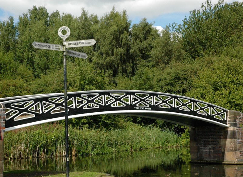
So engineers built a network of canals, known locally as ‘cuts’. These sped up the region’s links with the rest of Britain. The network was a forerunner to today’s motorways. Look across the Dudley Canal and we can even see a fingerpost pointing out the routes.
Notice how wide and straight this section of canal is. The Dudley Canal didn’t always look like this. There are plenty more changes to discover as we explore further.
A typical Black Country scene - Coalbrookdale by Night by Philip James de Louthenbourg (1801), Wikimedia Commons (CCL)
Directions
With the Visitor Centre behind you turn left so that the canal is on your right. Follow the towpath up to a metal bridge (Dunns Bridge). Cross over it then bear left. Continue underneath a stone bridge so the canal is on your left. Keep the canal on your left and follow the path alongside the trees. Note that in places the path can be boggy after rain.
The path curves round to the right and enters some woodland. Look through the trees for a large lake. Stay on the path and stop when you have a good view of the lake.
2 Bumble Hole Lake
We are now in Bumble Hole Nature Reserve. Look around this tranquil space. Several types of rare plants thrive here. You might spot the raspberry-shaped pods of ploughman’s spikenard, white daisy-like fleabane and the pink bristles of hare’s-foot clover. Visit at dusk and you might see bats darting about, including short-eared Daubenton's and tiny Pipistrelles.
The most obvious wildlife habitat though is Bumble Hole Lake. The water attracts coots, moorhens, ducks and grey herons. The lake might look natural but instead it’s the remains of a clay pit. From the 18th century clay was dug here to make pottery and bricks.
Clay soils are ‘impermeable’, which means that water doesn’t easily drain through them. So clay bricks were ideal for building canals. As we continue look along the towpaths for dark blue bricks. They are known locally as ‘toccy’ after a Black Country word for ‘chewy’ or ‘sticky’.
Toccy bricks were made from Staffordshire clay which turned blue and became almost waterproof when baked in the hottest part of the oven. Several companies made toccy bricks and often stamped their names into them. How many different names you can spot?
On the subject of names, why are the nature reserve and lake called Bumble Hole?
In the Oxford English Dictionary, ‘bumble’ means “to hum, buzz, drone, or move ineptly”. In other words, to mumble and stumble - as if you were drunk. There are accounts of at least 13 pubs near to the canal at Windmill End. So maybe the name ‘bumble hole’ describes a place where people ‘bumbled’!
Another story records that in the bottom of the clay pit (now the lake) was an iron shed with a large steam hammer inside. Local descriptions say the hammer made a loud clanking ‘bum-hul’ noise. It apparently became known as ‘the bum-hul in the hole’, soon shortened to ‘bumble hole’.
A further suggestion is that a ‘bumble hole’ was a name used for a furnace-opening in foundries. Nobody knows for sure where the name comes from but accounts like these give us clues to what the area was like before it became a haven for wildlife.
With Bumble Hole Lake on your right, follow the path through the trees until you reach another path running across it. Turn left and follow this path for a short distance. Another path appears from the right. Take this path so that another section of canal appears on your left. Continue until you meet the towpath of the canal again. The Visitor Centre where you started should be opposite to the right.
3 Opposite Bumble Hole Visitor Centre
We are now on the opposite side of the canal, almost back where we began. Notice how we’ve travelled in a big circle to get here.
Our route around the lake followed a section of canal called the Bumble Hole Branch. Compare this part of the ‘cut’ to the section by the Visitor Centre, which is much straighter.
Travelling on the waterways was faster than riding a horse but journeys still took days at a time. And when transporting goods around the country, lost time meant lost money. As a result the canals were constantly improved and altered to make them faster to use. Windmill End is one of several places where we can see the results.
The Black Country canal network developed from the 1770s with a series of routes that gradually linked up with each other. One of these was the Dudley Canal, made from 1779 to link Stourbridge and Tipton. Spanning 4½ miles it was mainly used to transport coal.
Though busy the canal was not a financial success, so almost as soon as it was finished plans began for an extension. Cut from 1792 this later 10-mile stretch became known as the Dudley Number 2 Canal to distinguish it from the earlier section.
Waterways like these are called ‘contour canals’ as they followed the natural layout of the land. Doing this minimised the amount of digging, with few tunnels or locks. But going around natural obstacles, like hills and forest, made the routes long and time-consuming to use.
To save time, later canals were built as straight as possible. Often they scythed through existing contour canals, creating loops or ‘arms’ to the sides. That’s what happened here.
The Bumble Hole Branch is part of the original Dudley Number 2 Canal, while the straighter waterway ahead of us is a later improvement. It was cut in 1858 to access a new tunnel and is called the Netherton Tunnel Branch.
We will see the tunnel itself a little later. When the Netherton Tunnel Branch opened, the Bumble Hole Branch became largely redundant. It was kept open for a boatyard. Today the towpaths are lined with tranquil greenery. But this wasn’t always the case…
Turn left and head towards the metal bridges of Windmill End Junction. Keep the Dudley Canal on your right and continue onto the nearest metal bridge. Stop halfway across it.
4 Boshboil Arm Bridge
The cast iron bridges here, including this one, are all Black Country products. They were made by the Toll End Works at Tipton in Staffordshire. Such bridges are common around the Black Country canals. Look on their sides and they are often stamped with the names Toll End Works or Horseley Iron Works.
This one is called Boshboil Bridge. Again its unusual name tells a story. Turn your back on the Netherton Tunnel Branch Canal and look at the waterway heading towards the lake. This is the Boshboil Arm. Its unusual name comes from a now vanished canalside industry.
As the canals spread, factories, furnaces and other working sites developed alongside them. Windmill End lies on a rich natural seam of coal, which was heavily mined for industrial uses. Some coal was baked in ovens to form coke, a solid fuel used in furnaces. Hot coke was cooled by dunking it in large tanks full of water called ‘bosh tubs’. A series of furnaces and bosh tubs sat alongside this part of the canal, hence the name.
A sign of this hissing and bubbling activity remains in another water feature. To the right of the Boshboil Arm is the Boshboil Pool. It’s also known as the Red Pool as the centrepiece is an orange-tinted hill. This mound is the remains of a ‘slag heap’, a man-made pile of mining waste. Its orange colour comes from a chemical reaction between oxygen, water and metal. The soil contains traces of iron from the long-lost furnaces – these have gradually ‘oxidised’ (in effect rusted).
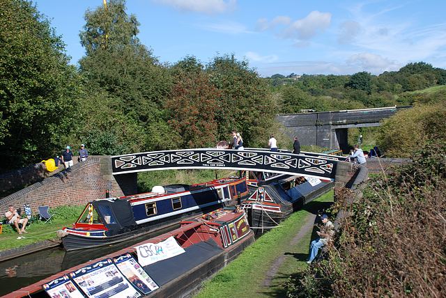
We will now go through Windmill End Junction by crossing the other bridges. As we do, see if you can spot deep grooves in the metal and surrounding brick walls. We will find out what made these at the next stop.
Continue along the towpath to the next bridge, turn right and cross it over the canal. With the Dudley Canal now on your right, head towards the Visitor Centre to the bridge with shallow steps and a brick wall dividing it. Stop halfway across the bridge, with the dividing wall on your right. There will be canals below you in four directions.
5 Windmill End Junction
From this bridge we can see how much the waterways evolved here at Windmill End. Routes branch off in all directions.
To the left, opposite the Boshboil Arm, is another branch of the Dudley Canal. It once linked with the Worcester & Birmingham Canal at Selly Oak. The stone rectangle we can see in the water is the remains of a toll island, a place where boats stopped to pay tolls for using the canal.
Today this junction is a quiet spot but if we were here 150 years ago we would be surrounded by industrial sights, smells and sounds. Boats groaning with cargo, canal banks crowded with working men, belching chimneys, roaring furnaces, pounding hammers and hissing bosh tubs.
We would also hear the clip-clop of hooves. Before engines developed, horses towed narrowboats along the canal - hence the name ‘towpaths’. To take cargoes through junctions, horses often had to cross bridges from one towpath to another. As they did, the tow ropes were pulled taut. The ropes gradually carved grooves into the bricks and iron rails.
It’s fitting there are many iron bridges around Bumble Hole as the area was once well known for metal works. Furnaces here made nails, boilers, chains and anchors. Local firm N (Noah) Hingley & Sons made the anchor for the ill-fated ship RMS Titanic. A replica stands in Netherton today and anchor symbols can be spotted throughout the town.
1911 advertisment for N Hingley & Sons Reproduced courtesy of Grace's Guide (www.gracesguide.co.uk)
Directions
Turn around and with the Dudley Canal and Boshboil Arm on your left retrace your way back to the towpath. Keep the canal on your left and continue underneath two bridges. The second one (Cobb’s Engine Bridge) is made of brick with a set of steps just beyond it. Head towards the large tunnel entrance ahead and stop when you have a good view of it.
Note: the towpath near the tunnel is grassy and can get very boggy after rain. If you prefer, you can view the tunnel from the top of Cobb’s Engine Bridge. To do so, take the steps just past the bridge then turn right.
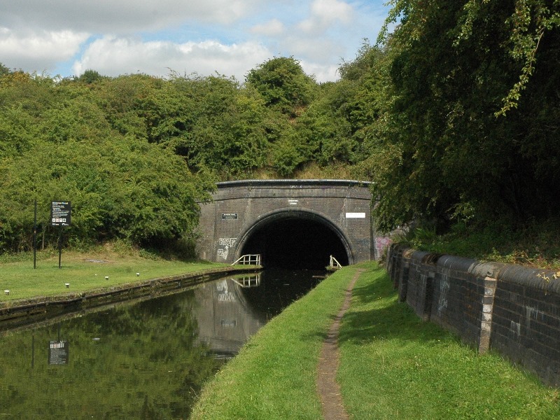
6 View of Netherton Tunnel
We are now by one of the Black Country’s most imposing landmarks, the gaping maw of Netherton Tunnel. Opened in 1858, it took three years to build using over 26 million bricks. A plate above the entrance records its length of 2,768 metres. That’s 1¾ miles - longer than 20 football pitches.
Also notice its width. Spanning just over 8 metres, it’s wide enough for two boats to pass each other. This was important as the tunnel was built to reduce congestion, rather like today’s motorway bypass roads.
The Dudley Number 1 Canal included a 2,900 metre long tunnel. Despite its length, the Dudley Tunnel soon proved too narrow to cope with traffic. Only one boat could use it at a time and there was no towpath. By the 1850s some 41,000 boats passed through it each year but they could wait outside for up to two weeks!
The mighty Netherton Tunnel helped to relieve the problem. Listen carefully and you may hear the echoing drone of a boat making its way along. Today’s diesel powered boats make the journey in almost total darkness. When the tunnel first opened it had gas lighting (later electric). Despite many renovations over the years, some of the original ceramic lighting conductors are still in the roof. You’ll need a good torch to see them though!
Despite its success, this was the last original canal tunnel built in Britain (some tunnels have been built since but for canal restoration). By the 1850s canals were being superseded by the railways, which could carry goods faster and cheaper across more areas of Britain. As the canals’ working days declined waterside industries closed or relocated.
Objects like the Netherton Tunnel have become icons of the Black Country’s industrial past. We will see another example at the final stop.
If you went along the towpath to Netherton Tunnel, retrace your way towards Cobb’s Engine Bridge. Just before the bridge, go up the steps on the left and continue onto the grassy hill. Stop when you have a good view of the tall building with chimney stack beside it. (From Cobb’s Engine Bridge the chimney is clearly visible, simply head towards it by bearing left.)
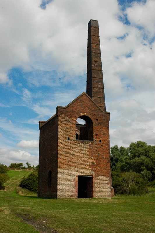
7 Cobb’s Engine House
Throughout Windmill End one object dominates the view, a massive chimney standing above the trees. We have now arrived at the source. The chimney belongs to Windmill End Pumping Station, commonly known as Cobb’s Engine House (Cobb was the name of the farmer whose land it was built on).
Notice how high up we are from the canal. The engine house was built here because we are above a series of deep coal mines. Coal forms over millions of years when plants are slowly compressed under layers of soil. The best quality coal is far underground, so deep shafts are built to extract it.
Completed in 1836, Cobb’s Engine House had a shaft of 160 metres (525 feet). Inside the building was a huge Newcomen engine. These engines were some of the first powered by steam and they became widespread throughout industrial Britain. To fuel the engine here a railway line carried coal along Cobb’s Engine Bridge.
But rather than extract coal this building pumped water. The mines were near a ‘geological fault’ – a crack in the rock below the Earth’s surface. The fault meant huge amounts of underground water drained into the mines. Cobb’s Engine House pumped this water into the Dudley Canal, keeping the mines dry and the waterway wet.
The pumping house closed in the 1920s after a series of strikes left the mines flooded. In 1928 Henry Ford, founder of the world-famous car company, bought the engine for his industrial museum in Michigan. Here, the remaining building is a listed Scheduled Ancient Monument - giving it the same protection as Stonehenge!
Today this building is a towering reminder of the link between coal and canals. Britain’s first canals were built especially for transporting coal and boats brim full of it travelled throughout the network. But the relationship wasn’t always happy. Did you notice how the Bumble Hole Arm suddenly stopped? And that the Boshboil Arm was rather short? These two sections used to join up until subsidence from nearby mines broke the loop.
Sadly, subsidence and pit collapses were common, especially in the early Industrial period. Mining cost thousands of lives in Britain alone. Mining also devastates the landscape. Notice the steep bank behind the chimney to our right. This is a ‘spoil heap’, a mound made up of land dug out from the mines. Its size reflects how deep Bumble Hole was mined and how much ‘black gold’ fuelled the surrounding industries.
The spoil heap is also our final clue to this area’s past. From this high position we can look over a gloriously evocative landscape. Throughout the route we have found traces of Windmill End’s former industries. The tranquil scene we can enjoy today vividly illustrates how waterways can be given new life and fresh purpose. The mines, furnaces, factories and sawmills may be gone but if you know how to spot the signs, they’re far from forgotten.
Windmill End is a tranquil spot in the Black Country town of Netherton. Today birdsong fills the air, people cycle or walk along the paths and you might even see water voles splashing into the canal.
The trees, lakes and grassy slopes are deceptive though. In the 18th and 19th centuries this open space was a noisy and dirty workshop, lined with a heady mix of factories, boatyards, blast furnaces and collieries.
This trail reveals the hidden stories of these bruising industries. We will search for clues to the area’s past and find out why Windmill End has another unusual name – Bumble Hole!
Follow the trail by clicking on the map pins or downloading the guide below
Black Country folklore reports the canals here were a haunt of 'Spring-heeled Jack' - a Victorian demon who attacked people at night and could leap over buildings!
 A book published during that time opens with a powerful description of the area: “The Black Country. Black by day and red by night, cannot be matched, for vast and varied production, by any other space of equal radius on the surface of the globe” (from Walks in the Black Country by Elihu Burritt, 1868).
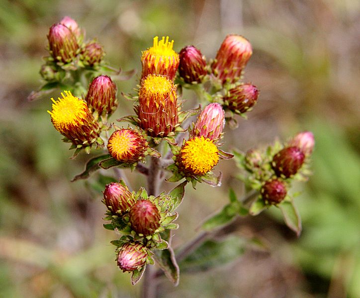
 The most obvious wildlife habitat though is Bumble Hole Lake. The water attracts coots, moorhens, ducks and grey herons. The lake might look natural but instead it’s the remains of a clay pit. From the 18th century clay was dug here to make pottery and bricks.
 Toccy bricks were made from Staffordshire clay which turned blue and became almost waterproof when baked in the hottest part of the oven. Several companies made toccy bricks and often stamped their names into them. How many different names you can spot?
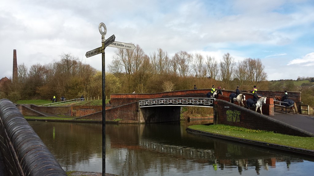
 A sign of this hissing and bubbling activity remains in another water feature. To the right of the Boshboil Arm is the Boshboil Pool. It’s also known as the Red Pool as the centrepiece is an orange-tinted hill. This mound is the remains of a ‘slag heap’, a man-made pile of mining waste. Its orange colour comes from a chemical reaction between oxygen, water and metal. The soil contains traces of iron from the long-lost furnaces – these have gradually ‘oxidised’ (in effect rusted).
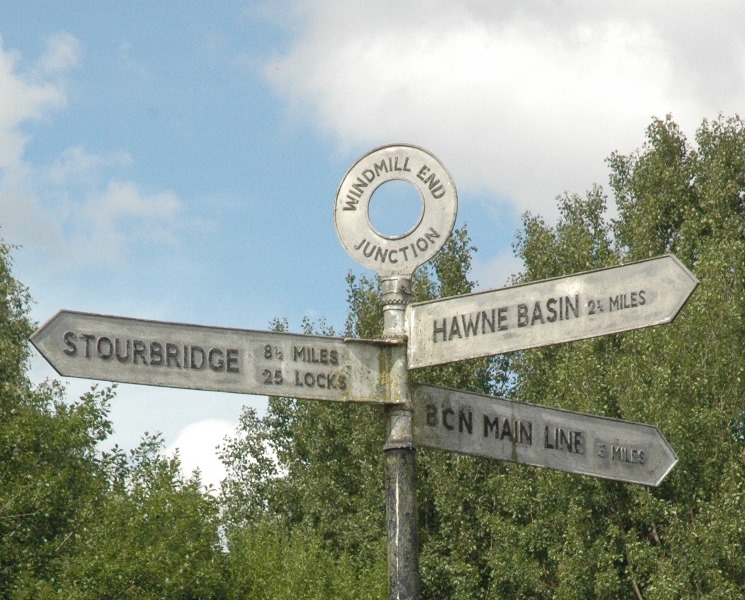
 To the left, opposite the Boshboil Arm, is another branch of the Dudley Canal. It once linked with the Worcester & Birmingham Canal at Selly Oak. The stone rectangle we can see in the water is the remains of a toll island, a place where boats stopped to pay tolls for using the canal.
 The mighty Netherton Tunnel helped to relieve the problem. Listen carefully and you may hear the echoing drone of a boat making its way along. Today’s diesel powered boats make the journey in almost total darkness. When the tunnel first opened it had gas lighting (later electric). Despite many renovations over the years, some of the original ceramic lighting conductors are still in the roof. You’ll need a good torch to see them though!