Hello and welcome to the South Wales Valleys. I’m Jennifer Lewis and I was born and brought up in one of the valleys – the Cynon Valley.
I’d like to tell you about a walk that my grandmother, Emily Roberts, did when she was young, just married and with a young baby. When she was living in the Rhondda Valley, she would walk right over the mountain to the Cynon Valley to see her family. This walk recreates Emily’s walk and along the way tells something of life in the Valleys a century ago.
Our walk takes us through a variety of landscapes – valley towns, re-claimed industrial sites, farmed and wooded slopes, open countryside and mountain moorland. This is a land of contrasts and surprises.
Along the way we’ll learn of the days before and after coal extraction. We’ll also find out how the landscape has changed since Emily’s days. In hearing a little about Emily, her life and family, we’ll learn about the valleys in the heyday of the coal industry.
I’ve lived in Australia since 1970, but over the years have been drawn back to these valleys fifteen times. It’s a beautiful area with wonderful walks, contrasting scenery and stories to enjoy. We start in the town of Ferndale in the Rhondda Fach Valley then go over the plateau to Penrhiwceiber in the Cynon Valley. From there you can return to the start point or continue your journey by bus or train. I hope you enjoy the walk!
From the Church of Our Lady of Penrhys on the main road go along New Street on the lower side of the church building. Follow this road for about 200 metres until you reach a set of steps on the right. Go down the steps and turn left onto Brown Street. After about 75 metres turn right down to Albany Street. Turn right and walk along to Number 30 on the right hand side.
2 Long terraces
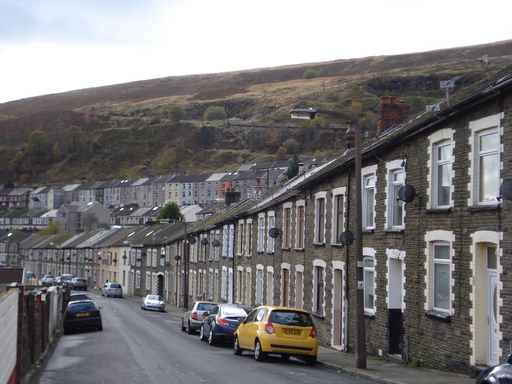
Albany Street is a typical valley terrace. It was built in the late-nineteenth century as part of a housing boom that occurred when new collieries opened up and workers came to live in the area.
As you can see, there was not much flat land available in Ferndale because the valley bottom is not very wide, so lines of terraced houses were built stretching up and along the mountain sides.
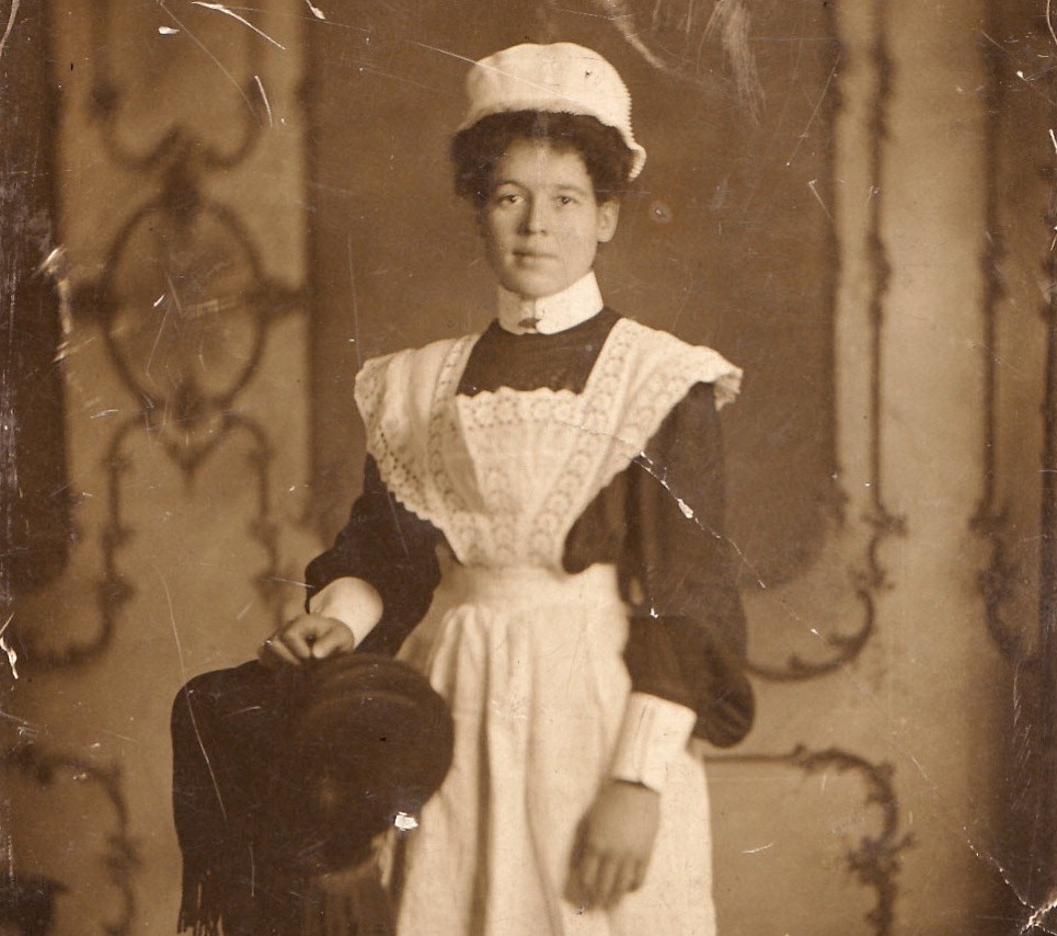
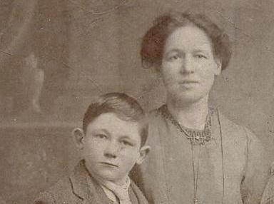
My grandmother, Emily, lived here at 30 Albany Street. She was from Penrhiwceiber in the next valley, the Cynon Valley, where we will finish the walk.
When Emily married her first husband, Edward, she moved here to Ferndale in the Rhondda Valley. They lived in Albany Street between 1910 and 1914 and their son, my uncle Eddie, was born here in January 1912.
Many people rented their houses from private landlords or colliery owners. In fact Edward and Emily had only half of Number 30; it was divided into two apartments. Emily and her family lived on the first floor and a family of four lived on the ground floor.
The houses have been modernised and extended now, but when they were built, the steep roofs were covered with slates and the downstairs floors were covered with flagstones.
There were just four rooms – two upstairs and two downstairs – plus a tiny kitchen area. In the small back yards were the outside toilets.
Notice how the front doors on Albany Street open straight onto the pavement. The houses may have been small but women took great pride in keeping their homes clean and tidy.
When I was a little girl, we lived with Emily (in a different house) and I remember her scrubbing the doorstep once a week as part of her cleaning routine. She would slap our legs with a wet cloth if we walked past!
Emily believed that children should not be made to work around the home. She said that there would be plenty of work in store for us when we grew up.
When Emily moved here to Ferndale, she was homesick. Her husband was on shift work and she missed her big family.
So sometimes she would walk between the valleys just to have dinner at her mother’s house. It is this walk that we are going to follow now.
Almost opposite Number 30 Albany Street is a short street leading down to a recreation ground. Go down the street and follow the path past the play area onto the grassy area. Stop halfway across the grass at the memorial to Sir Stanley Baker (actor and film producer born in Ferndale).
3 King Coal
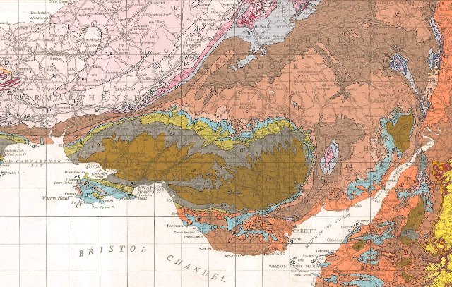
Look at any map of South Wales in the area between Cardiff on the coast and the mountains of the Brecon Beacons and you will see several striking features. One is that all the main roads run more-or-less in a northwest to southeast direction and this is a clue to the dominant physical geography of this area: a series of parallel valleys. On an Ordnance Survey map you will also see that the orange contour lines are very close together in places, denoting steep slopes. The narrow valleys are glacial, carved out more than 10,000 years ago. Their steep sides and flat bottoms form a distinct ‘U’ shape.
The valleys are separated by upland moors and are quite isolated from each other. The main road and rail network goes up and down each valley but there are only a few places where you can get across the mountains. This has made inter-valley communication very difficult. Although we call this area ‘the Valleys’, as a collective term, each valley has a distinct identity.
Long before the Ice Ages and the glaciers that carved out these valleys, this area was covered with tropical rainforest. Over millions of years trees and plants died and the organic matter accumulated and compacted into layers. These layers gradually hardened first into peat, later into brown and then into black coal. Coal measures lay virtually undisturbed for over 300 million years until the nineteenth century when the seams in these valleys were worked to extract different grades of coal – bituminous, steam and anthracite. Steam coal was exported all over the world and made the South Wales valleys famous.
All the men in Emily’s family – her father, husband, brothers and brothers-in law – were coal miners. They spent their working lives extracting ‘king coal’ which I think is rather a good term for something that provided so much energy, power and profit. On this walk we will see how the coal industry transformed the physical and social landscape. It changed the view, the economy and people’s lives.
Map of South Wales coal basin (geological map)
RGS-IBG Map Library
Directions
Continue across the grass to a break in the fence on the far side. Follow the path down to the riverside. Turn left on the riverside path and follow it for about 400 metres. Where the path forks, go left up the embankment. Stop at the memorial to miners who worked, were killed or injured in Ferndale’s four pits.
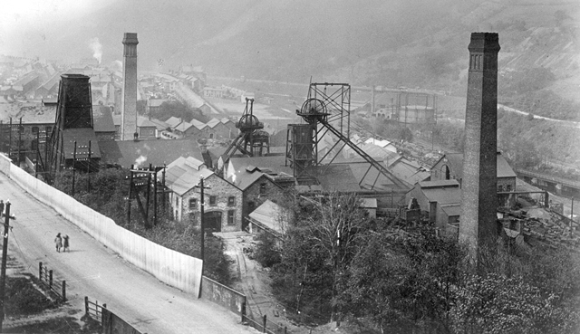
4 A busy, noisy, industrial place
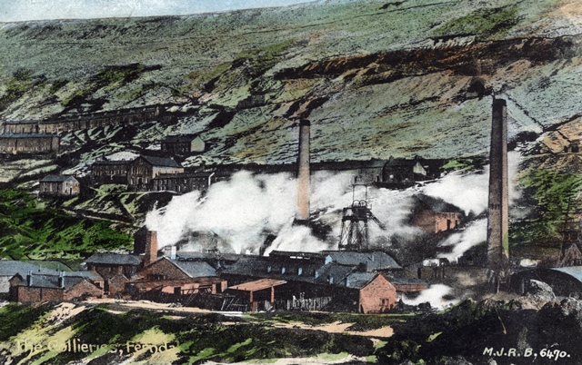
Coal was struck in Ferndale in 1862. By the time Emily was living here (1910-14), coal extraction had peaked. In 1913 almost 10 million tons of coal was extracted across the whole of the Rhondda Valley.
In Ferndale alone there were three large collieries that employed a total of 5,660 men, plus a number of medium-sized collieries that each employed over 1,000 men, as well as smaller concerns.
Underneath your feet is a huge warren of tunnels that extend throughout the coal basin.
In walking from her house to this point, Emily saw the workings of an entire industrial community. The development along the valley floor contained collieries, winding gear, chimneys and waste tips. The collieries operated 24 hours a day, every day.
There were pithead hooters that announced the change of shifts and there was the sound of hobnail boots on the streets. There was noise from steam engines and machinery, the grating of coal screens and the hammering of smithies. It was a busy, noisy, industrial place.
There was also a road and rail network plus electric trams, and street traders with their horses and carts. Shops, chapels, pubs, schools, workingmen’s institutes, libraries and theatres were all important parts of commercial, social and community life. All around were the sights and sounds of this place, existing for us now only as memories of a people long gone.
A great deal of what we see in the valley today is the result of regeneration. After the mines were closed in the 1980s, surface colliery sites were demolished and the land reclaimed. In fact the playing fields here were the site of one of Ferndale’s collieries and its waste tip. On these former colliery sites in other places you might find light industrial estates or other landscaped areas that the community can use.
Ferndale Colliery
RCT Digital Archives
Directions
From the memorial, follow the tarmac road up the slope. At the top turn right onto the main road and cross the bridges over the river and the former railway line. After the second bridge look for the steps up on the left hand side (which cut off the road’s hairpin bend). At the top of the steps turn left on Commercial Street.
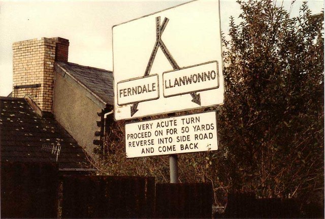
At the next junction turn sharply right into Blaenllechau Road. There is no pavement on the first part past the first two houses so take care. Stop where the pavement starts outside the third house on the left (Number 6) and look across the road at the sign for downhill traffic.
5 Acute turn
In 1860, before the days of coal mining, nothing much existed here except small hill farms. Part of this road was once an old sheep track.
Once motorised transport took off you can imagine the difficulty of negotiating this turn! Once there was a sign here that said ‘Very acute turn, proceed on for 50 yards reverse into side road and come back’.
This road climbs steadily up along the side of the valley. On the left looking up is Cefn Gwyngul, (meaning narrow white ridge). Look at a map and you will see distinctly the ridge’s characteristics. It is twelve miles long and stretches from Pontypridd to Hirwaun Common. The ridge road on Cefn Gwyngul was the drovers’ northern route out of the valley and was used to take stock to markets and fairs – sometimes as far away as Hereford and Northampton.
The mountains above the valleys have always been important to the people who’ve lived here.
Only a few minutes from the noisy industrial works and the cramped terraced houses is open space. For generations people have walked up here to enjoy fresh air, wonderful views and silence.
Local people refer to special places that they call their own. This is where Emily would have left people far behind and started to take in the beauty of her surroundings. As she said to me: ‘I’ve always liked walking; it clears my head’.
This slope is on the west side of the Rhondda Fach Valley. The east facing sides of the valleys are often in the shadow of the mountains behind them, particularly in the winter when the midday sun is low in the sky, whereas the west facing sides have longer periods of sunshine. Because of the extra light and warmth, vegetables on the west side mature three weeks earlier than on the east side. And some people think that living on the sunny side of these valleys make for a happier disposition and a more cheerful neighbourhood. My family, by the way, have always lived on the east side.
Follow the road as it climbs gradually up the hillside. There is no pavement so do take care as the road is narrow in places. After about 1 mile (1.6 kilometres) is a small lay-by on the right side for cars and a viewpoint. Stop here.
6 Welsh Wales
Welsh (Cymraeg) is the oldest modern European language and one that has a literary tradition dating back to the sixth century. Emily and her husband Edward spoke both Welsh and English. This was Welsh at home, in the street, in the mines and at Chapel whereas English was the official language of school, business and government.
When you look at the map of this area you may, like me, be transported to ‘Welsh Wales’. Just take a look at the names of places and geographical features. Many visitors to Wales have difficulty with these names because the combination of letters is hard for an English speaker to pronounce. But not to understand some Welsh is to miss out on the landscape around us because names of places are related to their history and geography.
Have you seen on the map that the Rhondda Valley we are looking down on is actually two valleys – the Rhondda Fach and the Rhondda Fawr. ‘Fach’ means ‘little’ and ‘fawr’ means ‘big’. Many places have both an English name and a Welsh name; for example Ferndale is also known as Glynrhedyn while Mountain Ash where we finish the walk is also known as Aberpennar.
This part of Wales was once heavily wooded and that may be seen in place names that contain the words coed (wood), fforest (forest), allt (wooded slope) and gelli (grove). Later on we’re going to pass two farmhouses called Gelli-Wrgan and Tir-y-Gelli that hark back to this wooded past.
Meanwhile we have walked from Blaenllechau (‘top end of the flat stone’) up Cefn Gwyngul (‘narrow white ridge’) and towards Eglwswynno (St Gwynno’s Church – eglwys is church). Llanwonno (or Llanwynno) means the place of dedication to St Gwynno. In place names, llan originally referred to an enclosure and then later came to mean ‘church’, especially a parish church. Llan is often linked with the name of a Saint. We’ll hear more about St Gwynno at the next stop.
Later on we’re going to stop at the Brynffynon Inn (bryn is hill and ffynon is well) and then see Cwm Clydach (cwm is valley) and Nant Clydach (nant is stream). All these place names are clues in the physical landscape as to what used to be – and may still be – there.
Continue up the road as it steadily climbs the hillside until it flattens out. Stop just before the gate and cattle grid.
7 Old Smokey
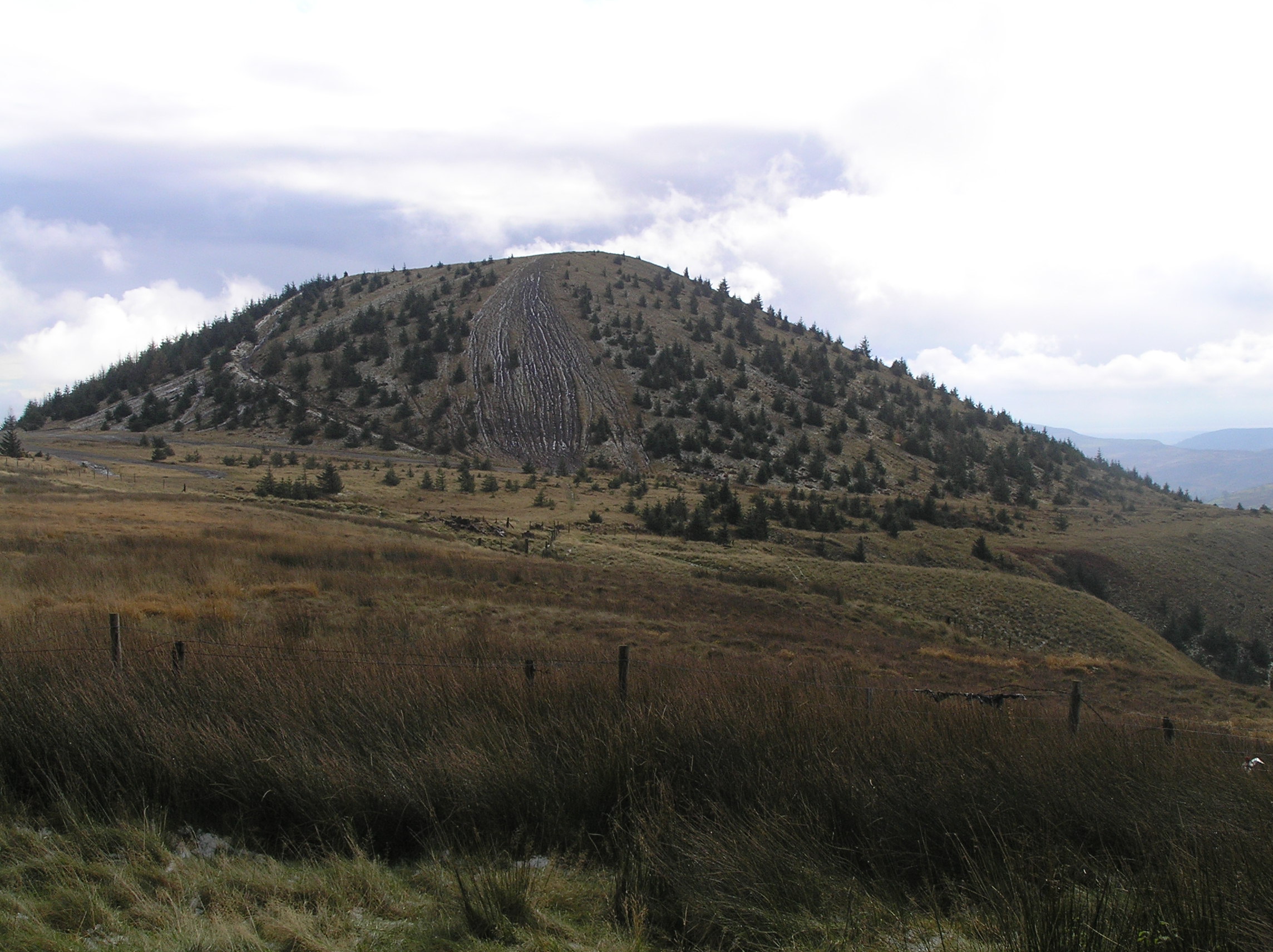
Although we are climbing up to the open countryside the landscape is not all natural. From this point we can see the old waste tip known to locals as Old Smokey. This name may have come about because some years ago the top caught fire and started smoking making it look like a volcano.
Marketable coal was transported away but pieces of shale, sandstone and small coal were just dumped. It was the same in mining areas across Wales and elsewhere in Britain where waste tips became dominant features of the landscape.
Tips that remain are a visible reminder of mining activity and its environmental and social cost. This one contains waste from both the Ferndale and Tylorstown collieries. You may wonder why there is a tip on the top of a mountain. As we have already seen, the valley floors are very narrow. Waste was originally piled up alongside the collieries but when the space ran out the material was taken up to the mountain tops. This is actually one of the few remaining mountain-top tips in South Wales.
In October 1966, there was a disaster at another mountain top tip at Aberfan in the nearby Taff Valley. After two days of heavy rain, the material on the tip loosened and rushed down the mountain. It destroyed a cottage then engulfed the junior school and some houses in the village. 144 people were killed, including 116 children of the school and five of their teachers. Following the Aberfan disaster, the Mines and Quarries (Tips) Act was passed in 1969. This Act requires that disused tips no longer constitute a danger to the public.
These days Old Smokey is a place of conservation and recreation. The slopes are being vegetated and it is a ‘site of importance for nature conservation’ under a Local Biodiversity Action Plan. It’s also a place that people come to walk and ride mountain bikes. I really recommend that you go up to the top because there are 360 degree views and on a clear day you can even see the Bristol Channel.
A diversion to the top of Old Smokey is highly recommended for the views. The slopes are very steep and the material can be loose so take great care. When you are ready go over the cattle grid and continue along the road for just over half a mile. Stop outside the church.
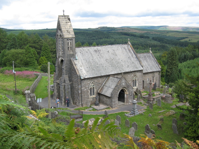
8 An ancient place of worship
This is St Gwynno’s Church in the parish of Llanwonno. St Gwynno was an early Celtic saint and it is said that during the sixth century he established a small monastic cell on this site.
The first church here was probably built of timber or wattle and daub. A more solid structure was then built in the twelfth century, resembling a barn from the outside with an appendage containing the chancel and a porch leading from the south wall. These features are incorporated in the present building.
In 1894 the Church was restored in the Gothic style. During the restoration a fragment of a Celtic cross was discovered; you can find it on the wall of the nave near the south door.
It dates from the period between the seventh and ninth centuries and is ranked among the early Christian monuments of Wales. We also know that St Gwynno’s Church was linked to the monastic school of Llantwit Major (Llanilltud Fawr), from which individual saints set out on missionary journeys.
St Gwynno’s is Anglican (Church in Wales). There are several tombs inside the Church, most of which date from the eighteenth century, whereas the oldest grave in the graveyard is from 1667.
Interestingly, inside the Church most of the inscriptions are in English, whereas outside in the graveyard Welsh predominates. This may have been due to an increasing Anglicisation amongst the old order.
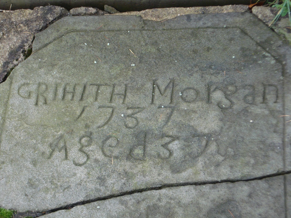
Go through the gate into the churchyard. If the church is open it is well worth going inside. Beside the gate is the west door. Go to the right round the corner to the south door. On the far side of the south porch is the grave of Griffith Morgan.
9 A sporting legend
This cemetery here in Llanwonno was one of Emily’s special places. It was not a depressing place to her at all, but rather where she liked to look at the gravestones of people she remembered. This is the gravestone of someone known to all locals: Griffith Morgan (1700- 1737), better known as Guto Nyth Brân, after nearby Nyth Brân Farm where he lived and worked.
Guto was a fast and courageous runner who ran on the flat, the steep hillsides and mountaintops, testing himself against sheep and horses. The legend says that he once outran and caught a hare and that he could even catch a bird in flight. It is also said that he ran from his home to Pontypridd and back (just over 7 miles) in the time it took to boil a kettle.
Siân O Siop, the local shopkeeper, was his manager as well as his sweetheart. Guto’s last race had a sad outcome, worth telling in some detail because this is part of his legendary status.
As the story goes, because he won his races easily, opponents became scarce and he stopped racing. Then in 1737, ‘Prince’, a new runner offered a challenge and Guto accepted. The race was over twelve miles and Guto won in the record time of 53 minutes. His tragic death came about when Siân gave him a congratulatory slap on the back and he collapsed, dead in her arms. His body was taken to its final resting-place here in the graveyard of Llanwonno church. The large tombstone was erected by public subscription in 1866, over 100 years after his death.
Guto’s racing ability is celebrated down in the Cynon Valley every New Year’s Eve as part of the Nos Galon Races. The event began in 1958 with some of the most famous sprinters in Great Britain, as well as locals, competing over different distances. Every year a famous sports personality – whose identity is kept secret until the night – lays a wreath on Guto’s grave. The ‘mystery runner’ then runs to Mountain Ash carrying a flaming torch. Past mystery runners include David Hemery, Lilian Board, Neil Jenkins and Linford Christie. Recently, rugby player Shane Williams and runner Rhys Williams ran down the mountain together.
Do take time to explore the graveyard and enjoy the views although take care as the ground is uneven in places. When you are ready leave the churchyard by the gate and turn left onto the road. Go left round the corner and stop outside The Brynffynon.
10 1A place to pause
We are almost at the halfway point in Emily’s walk, in the little village of Llanwonno. Now it has only the church, a public house and a few isolated farmhouses but it was once the religious, civil and cultural centre for the Rhondda Fach and Cynon Valleys.
Llanwonno was a natural gathering place for the area. This village gives us a glimpse of life in the area in the days before coal. Traditionally, local people reared cattle and sheep, while others grew crops.
Here in Llanwonno could be found the support trades of blacksmith, carpenter and stonemason.
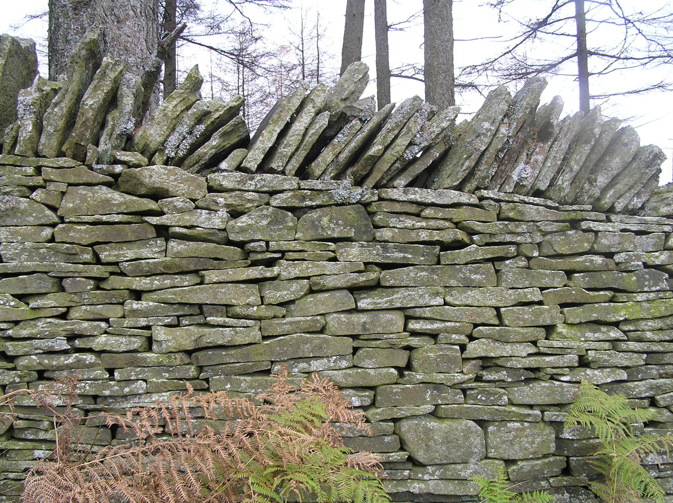
You might have seen many beautiful stone walls as you’ve walked along and these are reminders of the old rural craft of stonewalling.
The Brynffynon was built in the seventeenth century as a small public house but is now a traditional family-run hotel.
Here, near the highest point on the walk, Emily might have taken a break for a few moments to readjust her young baby.
I remember her telling me: ‘I would walk with the baby in a big shawl wrapped around me, right over the mountain’.
She carried her baby in the Welsh way using a large (usually six-foot square) nursing shawl made from woollen flannel.
It was a very practical arrangement with the baby being held tight and warm in front, the mother’s left arm supporting the baby but still useful, and the right arm fully free.
Here are the instructions for carrying a Welsh baby:
- Fold the shawl into a triangle
-Place over both shoulders
-Lift baby into place on left shoulder
-Wrap the left corner of shawl around the baby
-Drop the right side of shawl under your right arm
The Brynffynon is the only place en route that serves refreshments so a stop here is highly recommended.
When you are ready continue down to the road through the dip and follow it for about 300 metres. Stop when you reach a crossroads with a forest track going down to the left and a car park on the right.
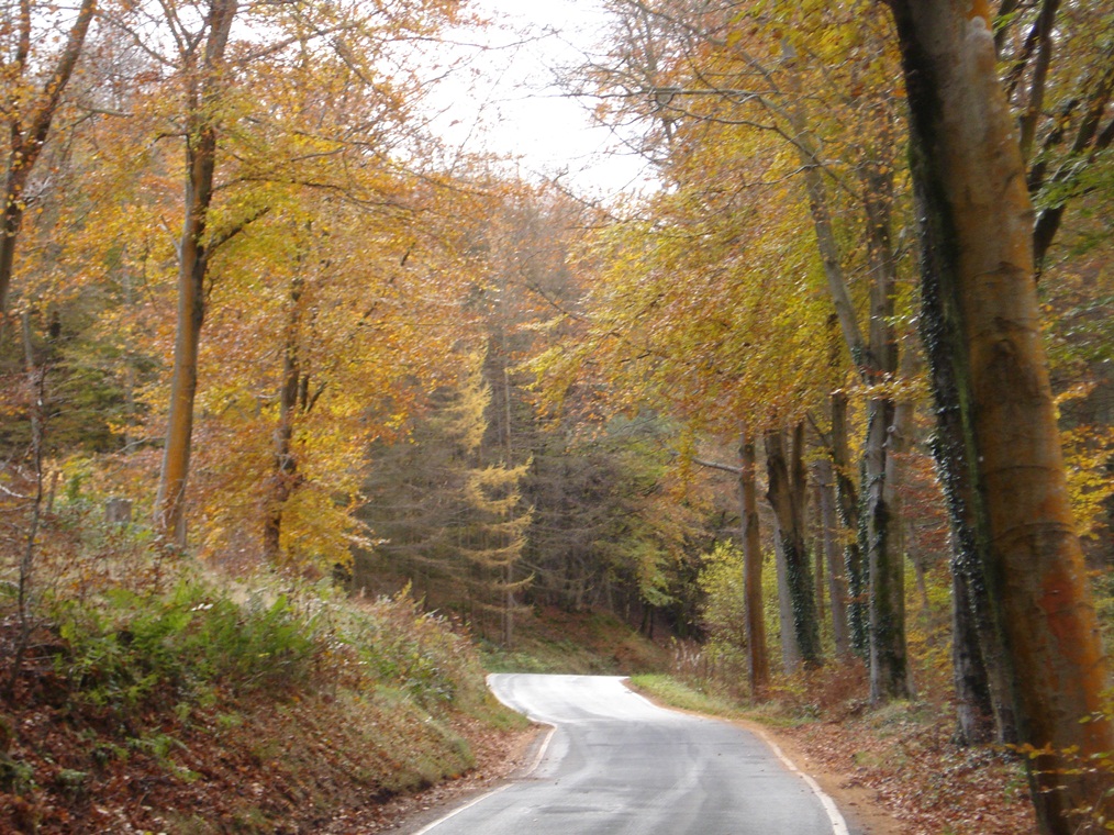
11 Mixed woodland
When Emily spoke about this walk, she would say that for much of the way squirrels ran from tree to tree and did not have to touch the ground because the trees were so thick. She was walking through native woodland, which contained mixed broadleaf hardwoods with a preponderance of oak (derw in Welsh), beech (brew) and ash (onn).
Over time, many oak trees and other hardwoods were cut for use in the smelting and shipbuilding industries of South Wales, as well as for pit props here in the coal mines and during the two world wars. Large swathes of natural woodland were lost.
In the 1960s the Forestry Commission did some replanting although not of oaks which take hundreds of years to grow but of fast-growing conifers such as Japanese Larch and Sitka Spruce.
These commercial plantations, however, limit the number of plants that can grow at ground level, which in turn removes the habitat of a wide range of birds and animals. This loss of biodiversity has since been recognised and the Forestry Commission is now thinning the conifer crops in some areas in order to encourage the re-colonisation of mixed broadleaf woodland.
As you walk along it’s possible to spot the difference between the native deciduous woodland and the planted conifer forest.
Continue along the road for about two-thirds of a mile (1 kilometre) until you reach a forest track which forks back down to the left. Stop at the top of this track.
12 An inspiring landscape
Here, high up above the valleys we get a sense of the pre-industrial landscape of this area.
Beautiful landscapes like these drew travellers, writers and artists to the area in the early part of the nineteenth century.
This was a time when there was a fashion for exploring and writing about the natural wild parts of Britain. The Picturesque movement, which aimed to interpret the landscape through an artistic lens, was also popular at this time.
In 1803 the well-known traveller Benjamin Malkin followed the river Rhondda from Pontypridd up the valley and saw a salmon leap at Berw Rhondda (berw means ‘rush of water’).
He commented on: ‘the composure and solitude of the place, undisturbed by anything but the roar of the projected stream and the dashing of the spray’ (The Scenery, Antiquities, and Biography of South Wales, 1804).
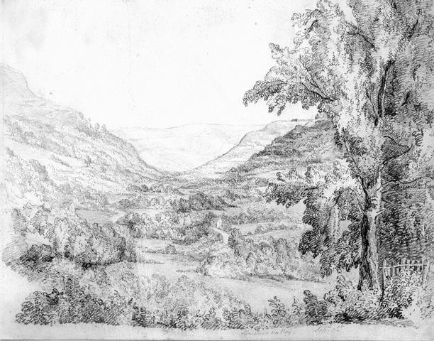
Thomas Roscoe, a writer of major topographical works, visited the Rhondda Valley in 1836 and was so impressed that he wrote:
‘I had now entered into the wild and mountainous region, where nature seemed to reign in stern and unbroken silence. Not a human being besides myself appeared to be treading these solitudes, nor was there habitation to be seen’ (Wanderings in South Wales, 1837).
Artists who visited included Henry Gastineau (1791-1876), a topographer, engraver and landscape artist and Emma and Lucy Bacon who made a series of pencil sketches.
The Bacon sisters were the granddaughters of the founder of the Cyfarthfa Iron Works in Merthyr Tydfil. In the 1820s they travelled around the Rhondda Fach and Cynon valleys recording rural settings.
Bacon sisters pencil drawings
Aberdare Valley
RCT Digital Archives
Directions
Continue along the road as it undulates for about half a mile. When you reach a junction turn left which is signposted Mountain Ash 2 ½ miles. Go down the road as it descends steeply. Stop on the bridge at the bottom.
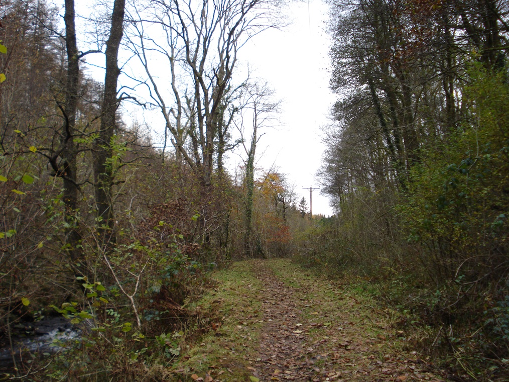
13 A natural playground
We are standing on a bridge overlooking a secluded and tranquil riverside valley, known locally as ‘the Cwm’. Here we pause in Emily’s memories for some of mine. As a child, I used to walk here from the Cynon Valley.
For me and for many of my generation, the ‘Cwm’ is remembered as somewhere where we went adventuring as children. I was never by myself but always with a loosely knit street gang. It was the last word in companionship, all together, yet in an important way, alone.
At every opportunity we played on the mountains and at times, especially in summer, we would range as far as the Cwm. In those days wandering sheep kept the grass cropped and the banks were wide enough to play cricket.
It had a rushing stream and there were places where we would block the stream so that we could swim. This would only be for a few strokes and the water would be icy cold. Shallow rocky pools really, but you could ease yourself out of the water, flop onto the rocks and look at the sky, the trees and the birds as they flew by. There would be other gangs around, climbing trees, lighting small fires on the banks. This little area was full of things to see and do.
Further upstream are small waterfalls and places to fish. We used to catch tadpoles in the marshes higher up. As we walked home (depending on the season) we would pick bluebells, pussy willows, wimberries, elderberries or blackberries. Emily and my mother were great bakers and made delicious tarts filled with apple, blackberry, gooseberry or rhubarb. Emily had a ‘sweet tooth’. She liked little cupcakes with icing on top and Welsh cakes cooked on a bake stone over the fire: nice to eat when they were still warm.
If you are on the bridge, retrace your steps and just before the steep hill turn right through two sets of barriers onto the riverside path. Continue with the river on your right for about 400 metres until you reach a footbridge.
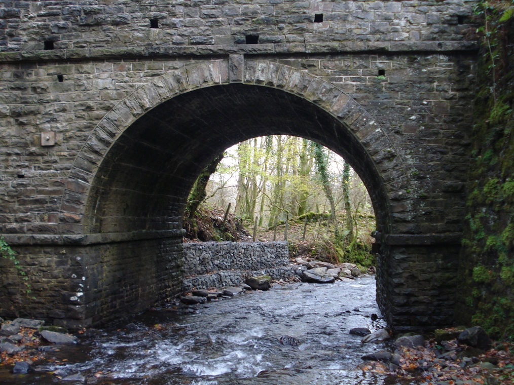
14 Branch line
Following this track upstream along Cwm Clydach provides a quiet and picturesque walking experience so you may be surprised to hear that a railway once ran along this valley.
It was a branch line of the Taff Vale Railway, one of the oldest Welsh railway companies to link coalfields and passengers with Cardiff and the South Wales ports.
In the 1870s the untouched coal reserves of the upper Clydach valley were surveyed. It was probably thought that the resources of this valley could be exploited along the lines of the adjacent Rhondda and Cynon valleys.
Some levels and small collieries were in fact developed, but proved to be unviable.
The railway along the Cwm, a single-track line from Ynysybwl to the upper reaches of the Clydach Valley, opened in the 1880s. It did not carry passengers but coal and supplies for small mining concerns as well as for isolated farming communities.
The potential for coal extraction in the valley was not realised and the line was eventually closed and dismantled.
After crossing the footbridge continue with the river on your left for about 200 metres where there is a footpath off to the right signposted as the ‘Loops and Links’ trail. (If you reach another footbridge over the river you have gone too far.) Follow the path over a stile and up the hillside. It is narrow and can be rough underfoot. After a short distance the path turns to the left and passes between two stone walls as it continues to climb steadily upwards. When you reach a gate go through and stop by the farmhouse.
15 Isolated rural life
The rough track that we’ve followed up to this farmhouse is well known to locals. It’s the part of Emily’s walk that goes along the riverbank, up the hillside and ‘over the tops’ to the next valley.
The track was used by people walking between Mountain Ash and the Cwm, and also by farmers on horseback when driving their cattle from grazing grounds on the west side of the valley down to the Cwm to take in water.
There’s also a story that St Gwynno’s church bell was once stolen and carried this way to Mountain Ash (and from there over the Merthyr mountain).
If you look at the map of the area you’ll see that between the Rhondda Fach, Clydach and Cynon Valleys there is a criss-crossing of routes. Llanwonno, Pistyll Goleu waterfall and the Cwm were once popular destinations for people who lived in the Valley towns.
At one time there were wooden benches at strategic points along these routes and you would often see people taking a break and chatting with fellow walkers.
In standing here it’s possible to imagine something of the simpler lives of our forebears. The original Gelli Wrgan farmhouse was built in 1616 although the earliest reference to a building here dates back to 1597. We heard earlier that ‘gelli’ means grove; Wrgan derives from a person’s name. On the lower side of the complex are the original farmhouse and barn, now ruined.
Next to the ruins is an old yew tree that is at least 600 years old. Yew trees are not native; they were deliberately planted to show travellers a significant place. This is further evidence that this path follows a historic routeway.
This part of the Valleys remains entirely rural with a few farmhouses and holdings sloping down the hillside to the Cwm Clydach valley. Stone walls, boundary fences and pathways divide the land.
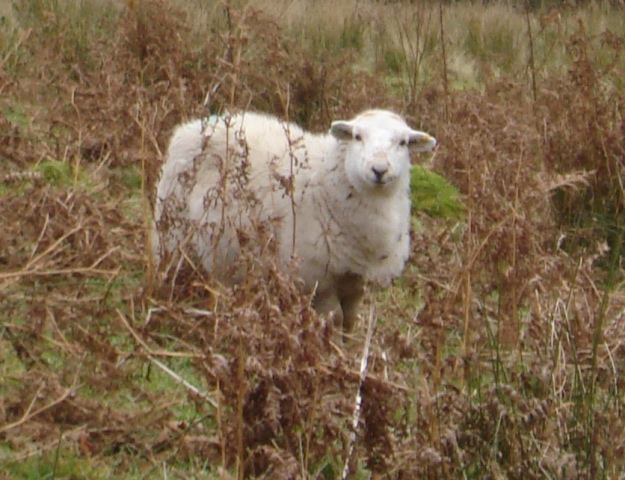
If you look over the stone wall towards the next farmhouse at Tir-y-Gelli (house in the grove), you may see sheep, horses and Welsh ponies in the fields. You are less likely to see foxes, squirrels, owls and badgers but they all live around here. It’s a place of peace and quiet. This farm building was well placed to provide shelter from northwest winds in winter, while the southeast facing aspect gave longer hours of sunshine in summer.
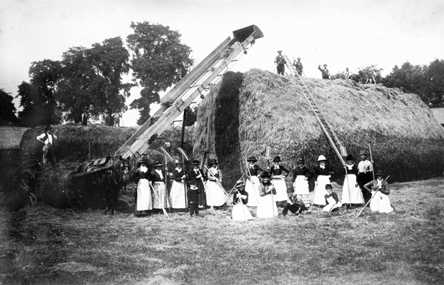
In the old days farming communities worked together on big seasonal tasks such as cutting hay, ploughing fields, reaping crops and shearing sheep. In this area the communal custom was known as ‘Y Cymorth’; roughly translated this means ‘free help’.
Farm work was done without machinery; tools were scythes, pitchforks, rakes, mattocks, shovels and hand shears. Sheep farmers used dogs and local sheep dog trials were held annually on August Bank Holiday. They were very popular and provided a bridge between farming and town life.
Have a look at the small out-building opposite the farmhouse. Above the door is inscribed ‘not my own, my native land, Wm Jones June 18, 1860’. This is a subtle and deliberate mis-quote from Walter Scott’s patriotic poem, ‘My native land’. The Welsh tenant farmers used this quote to comment on the unfairness of English landowners, who treated them in a subservient manner. They were required to pay leases or rent for land they thought they should own outright.
Haymakers at Aberaman (c.1880s)
RCT Digital Archives
Directions
From the farmhouse, continue up the lane as it winds its way up the hillside. Do stop from time to time to look at the view including back over the top of the forest to Old Smokey. About half a mile from the farmhouse the lane reaches its highest point and makes a sharp bend to the right. On the left side of the lane are some large stones at the bottom of a footpath which is marked as part of the Loops and Links trail. Follow the grassy path up the hillside. Stop at the gate at the top.
16 The top of the world
You might be out of breath when you reach this spot but the unrestricted view is worth it!
This stretch of open moorland is bleak and beautiful. Rough fields, marsh, tussocky grass, bracken and heather are in the foreground and in the distance are dry stone walls and maybe a few sheep.
The tops were seldom cultivated except in times of extreme hardship. The position here is exposed and the weather unpredictable. It may be mild, wet, cloudy, windy, changeable, cold or sunny. Emily did say that she once got sunstroke one afternoon while doing this walk.
Many of the people who migrated to the mining valleys were from rural Wales and neighbouring English counties.
Up here they were not far removed from the country background they had left behind. They were used to walking and liked the old country roads that took them up the valley sides and even over into the next valleys.
Some days the only thing that seemed worth doing was to follow a mountain path. On open moorland like this you can feel like the only person alive in the world!
Go through the gate and keep to the right side of the field with the dry stone wall on your right. After a short distance you reach a farm track crossing the path but continue straight on with the wall on your right. A short distance after passing under some power lines, the wall turns 90 degrees to the right towards a farmhouse. Stop here at the corner where there is a marvellous view over Mountain Ash below.
17 A changed landscape
A custom followed in the Valleys, as indeed elsewhere in Britain, is to ‘walk along part of the way’ with family and friends.
It’s at this point of Emily’s walk that she would have been met by one of her family (usually one of her brothers) who would have walked with her the rest of the way to the family home.
Later she would have been accompanied in the same way for part of her return journey.
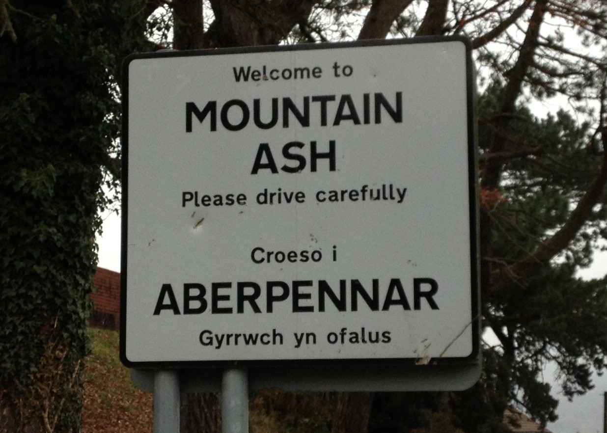
From here we can see down into the Cynon Valley and the town of Mountain Ash. It’s a surprisingly English-sounding name in this area full of Welsh names.
It is said that the bride of one of the local landholders held the leaf of a Rowan tree – which is also known as a Mountain Ash – in her hand at the site where a local inn was being built. She expressed the wish that the inn be called the Mountain Ash Inn and thereafter the town was also called Mountain Ash. In fact Mountain Ash has a Welsh name, Aberpennar (Mouth of the Pennar brook).
Up until the 1800s there was only a scattering of farms on the mountains and a few houses grouped around the Mountain Ash Inn.
The scene you would have seen from here would have been quite natural but the coal industry changed everything.
Development began in the 1830s, with coal extracted for use in the iron smelters of Dowlais and Merthyr.
After 1850 more collieries were opened. The impact can be seen in the population statistics. In the 1841 Census the population was 250 but by 1871 it was 11,463.
As we could see when we looked over Ferndale, here too we can see evidence of regeneration. The collieries have gone and the waste tips have been removed and in their place are landscaped areas and a light industrial estate.
Down below you can also see the River Cynon. It was once a polluted stretch of river, full of silt and rubbish, but it has now been cleaned up. The banks are protected and there’s also a walking track along it with a series of stone wall sculptures. And the water itself is healthy now: indeed my father told me that the kingfisher has returned.
Penrhiwceiber Colliery
RCT Digital Archives
Directions
Follow the path towards the farmhouse and then diagonally downwards below the grounds of the farm. Continue following the path diagonally down the hillside. When you are almost beneath the overhead power lines and close to a pylon look for a small quarry below. Stop here.
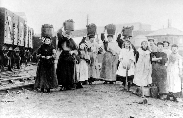
18 Strike and riots
We’re heading down to Penrhiwceiber (which means the ‘top of the hill where the trees look like a joist’) which is a suburb of Mountain Ash. The pit in Penrhiwceiber was sunk in 1872 and seven members of Emily’s family worked there.
A major preoccupation at the time of Emily’s walk was the great wave of industrial unrest that was sweeping the Welsh coalfield. There were major disputes over the method of calculating wages by linking them to the amount of coal extracted and making no allowance for difficult or dangerous conditions.
Eight thousand men went on strike in the Cynon Valley from October to December 1910, while twelve thousand went on strike from October 1910 to September the following year at Tonypandy in the Rhondda valley.
The riots that occurred in Tonypandy remain controversial to this day because of the use of troops to supress rioters. Radical activism had its own vocabulary – syndicalism, solidarity, socialism – and its own press and pamphlets like ‘The Miners Next Step’, published in 1912.
Women collecting coal during 1910 strike
RCT Digital Archives
Directions
From beneath the overhead power lines make your way down through the small quarry to the road. Turn left down Llanwonno Road and then fork back right into Arthur Street. Follow Arthur Street to the very end then turn left down Irene Street. At the T-junction at the bottom turn right along Woodfield Terrace. Go along Woodfield Terrace for about 500 metres until you reach Number 1. Go down the set of steps opposite Number 1 to Penrhiwceiber Road. Stop outside the Chapel on the right side.
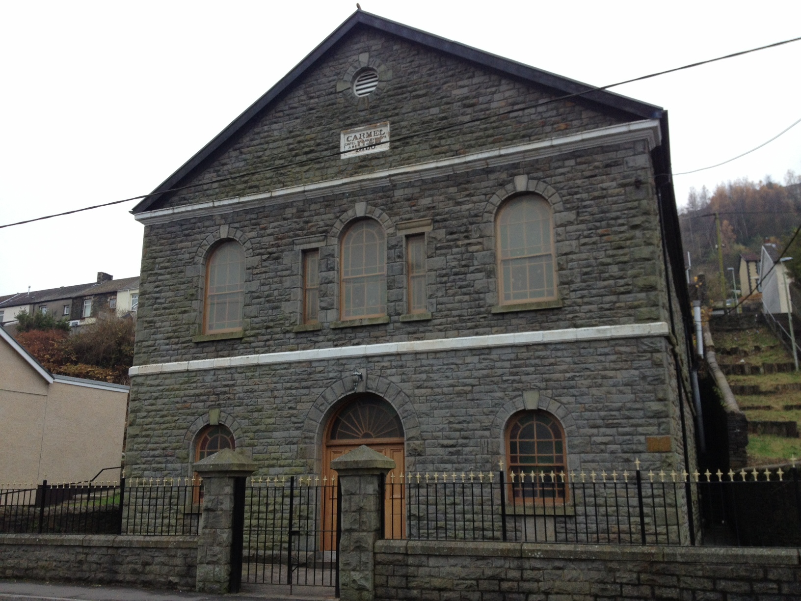
19 Centre of the community
Earlier we saw St Gwynno’s Church which has an association with the early Christian era in Wales. But St Gwynno’s stands in contrast to the many NonConformist chapels that were established in mining settlements as their populations increased. Religious revivals swept through the valleys in 1859, 1879 and 1904-5 (the latter was the biggest Christian revival in Wales) and the number of Non-Conformist chapels soon surpassed Anglican and Catholic churches. The Non-Conformist movement was popular in Wales because it was more equal and democratic and had rejected the rituals and symbolism of the established Church.
Chapels were amongst the most important buildings in the valley towns. Almost everyone went to chapel and there were many chapel activities that brought people together. Not only worship, Bible readings and Sunday School but also concerts and outings. The chapels were also a popular focus for Welsh language cultural gatherings such as the Eisteddfod (festival of the arts) and the Gymanfa Ganu (hymn singing festival).
This is Carmel Welsh Independent Chapel, the one that Emily attended. When it was opened in 1881 it was Congregational (Independent) with services in the Welsh language. Carmel is the oldest chapel in Penrhiwceiber and the first of five Non-Conformist chapels to be built on Penrhiwceiber Road. It has a modest exterior but inside is quite impressive with a fine pulpit and decorated pipe organ.
Emily was born in 1885. She belonged to the days when stories from the Bible and chapel hymns influenced everyday life, so there were many biblical references in her speech. ‘Iesi Mawr’ (Big Jesus) she would say when she was impatient with something. ‘Ask and it will be given you’ she would say when, as children, we hung around not saying what we wanted. The first lines of some of the hymns she sang say a lot ‘Nid wy’n gofyn bywyd moethus (I seek not of worldly treasures) and ‘Blessed assurance, Jesus is mine’ with its lovely chorus ‘this is my story, this is my song’. And, of course, ‘Cwm Rhondda’, the hymn that’s sung at rugby matches, ‘Guide Me, O Thou Great Jehovah’.
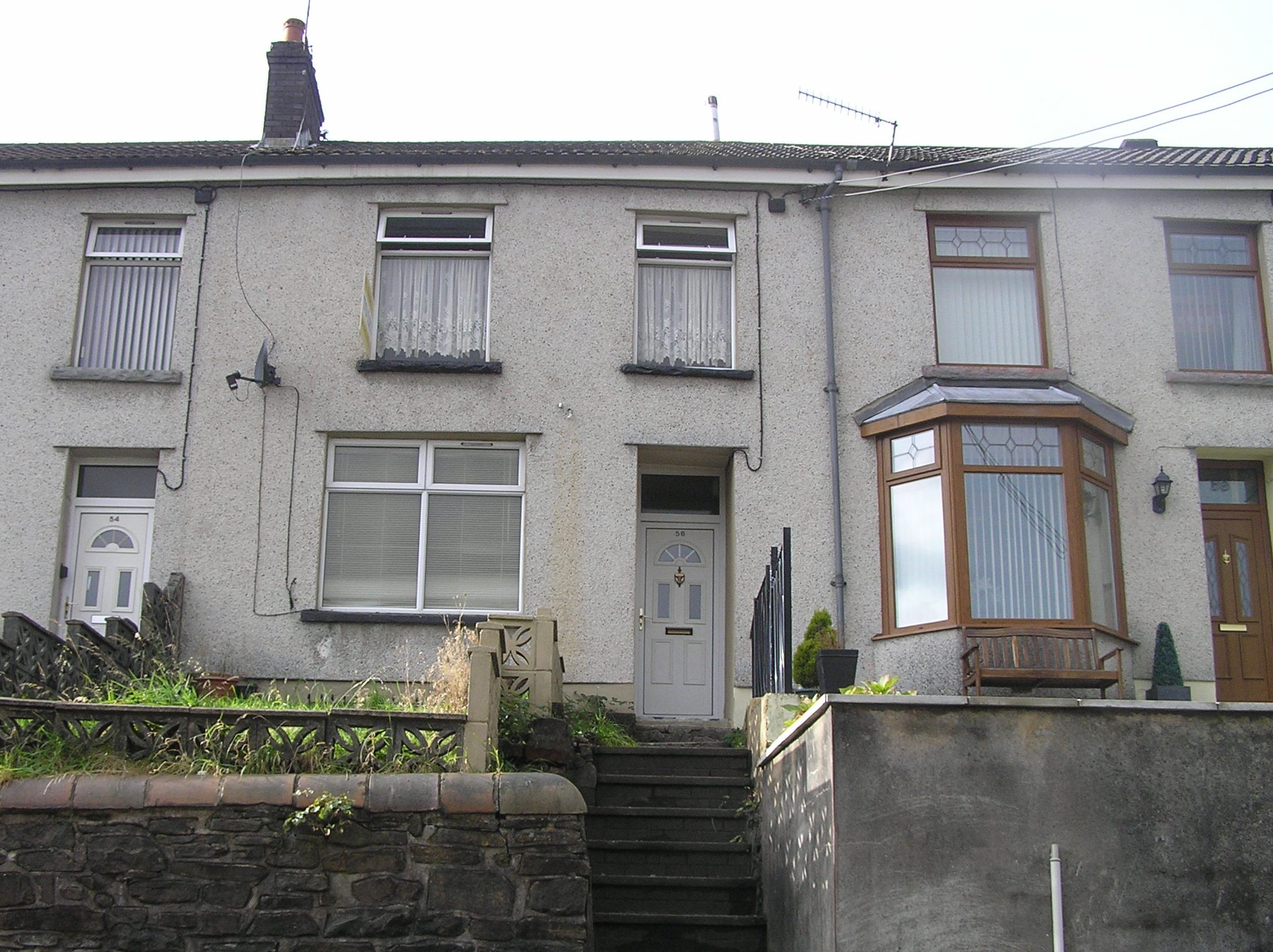
Return up the steps to Woodfield Terrace and turn left, where it becomes Church Street. After about 300 metres, turn right round the corner of the former school building into Cross Street, and then take the first left into Morris Avenue. Stop outside Number 56 on the right.
20 A hard life but a happy home
We’ve now reached the end of Emily’s walk from her first marital home in Ferndale to her family home here in Penrhiwceiber.
Here at 56 Morris Avenue lived the Williams family: Emily’s father Alfred and her mother, Elisabeth, as well as five of their eight children – Alfred, John, Elisabeth, Margaret and Beatrice.
Her brother, William, and sister, Annie, were married with young children and lived nearby. Emily would have been delighted to arrive home and enjoy dinner round the table with her family.
Streets like these would have been busy with activity. While men left for their shift down the pit, women washed down the steps and the pavements outside their houses. There were coal deliveries, milk and bread deliveries, and the call of the ‘rag and bone man’. People took a break while standing on their front doorsteps and children played in the streets. Before the days of cars, popular games were skipping, hopscotch, ‘whip and top’, jacks, flicking cards, street cricket and football.
Cutting coal was hard, dangerous work but life was not easy for the women either. Emily, like many other women, spent her entire life scrubbing, cleaning, washing, ironing, cooking and looking after children.
The hardest work was lifting big buckets of water for the men’s baths when they came home from work.
There were some activities that Emily didn’t see as work (like polishing the silver and brassware) because she was sitting down when she did them.
Sometimes she would say somewhat ironically, that ‘a lot of fetching and carrying goes into looking after men!’
I hope you have enjoyed this walk that has recreated one that my grandmother, Emily, did between 1910 and 1914. Young, strong and carrying her baby in a shawl, Emily would walk over the mountain between the Rhondda and the Cynon valleys to see her family. This may sound incredible to us now but in those days’ people walked just about everywhere.
Through Emily’s eyes we have learned a little about the coal industry that came to dominate the landscape of the valleys. People were drawn from rural Wales and other parts of Britain to the possibilities of work, albeit dirty and backbreaking. These once-isolated and peaceful valleys were transformed into an industrial landscape of pithead gear and waste tips, as well as housing for the miners and their families which stretched up the valley sides in long terraces.
But we’ve also seen how Emily and many others escaped up to the woods, moors and mountains where the sense of open space, the fresh air and countryside pursuits were in complete contrast to their everyday lives down in the valleys.
We have walked through a variety of landscapes and along the way we’ve observed those things that have changed and haven’t changed since Emily’s day. We saw light industrial estates and playing fields that have replaced the colliery sites. We saw a mountain top waste tip that has been turned into a viewing platform and a place for recreation. We saw forest plantations that have replaced native woodland. And we saw remnants of the agricultural past in dry stone walls and old farmhouses.
These days many people move away from their first home, including myself who moved from these valleys to live on the other side of the world. But in Emily’s day most people stayed where they were born. Her move to Ferndale about six miles away felt like a long way. She was connected at every level to her community and her surroundings through place, class, family, occupational group and language. She belonged.
I hope you have found this walk remarkable – for the wonderful views, for the diverse scenery and for the fascinating stories that this landscape has to tell. But we must remember that for Emily her walk was unremarkable.
If I could choose one image of my grandmother it would be this: Sometimes she would walk the whole distance between two valleys to her mother’s house for Sunday dinner; she walked carrying her baby son securely wrapped in a big shawl. She was a great walker, Emily
Retrace your steps along Morris Avenue and turn right down Cross Street past the school. At Penrhiwceiber Road use the pedestrian crossing to go straight across into the continuation of Cross Street. Turn left at the end into Station Terrace. After a short distance take the footpath forking off to the right which drops down to the station. From here you can catch a train towards Aberdare or Pontypridd and Cardiff.
Your browser is out of date, and unsupported by this website. Please upgrade to the latest version to use this website.
Coal mining transformed rural South Wales. The Valleys became an industrial landscape, with houses built in long terraces between collieries and waste tips.
Miners and their families loved to escape from the noise and pollution. This walk recreates the journey of Emily Roberts, who from 1910 to 1914 regularly walked through the countryside from Ferndale in the Rhondda Fach valley to Penrhiwceiber in the Cynon valley.
Follow in her footsteps to enjoy moorland and mountains, forests and glades, streams and waterfalls. Also discover how the valley towns have changed since the decline of the coal industry.
Follow the walk by clicking on the map pins or downloading the guides below
Oakland Terrace, Ferndale, Rhondda Fach Valley, CF43 4UB
Finish point:
Morris Avenue, Penrhiwceiber, Cynon Valley, CF45 3TW
Welsh Valleys walk credits
Thanks to -
Emily Roberts, the wonderful lady who inspired this walk
Jennifer Lewis for creating and narrating the walk and providing photos
David Newman for help with checking the route and mapping
Valerie and Heather for adding their family memories
Howard and Gwylythyn for helping to check the route and additional anecdotes
Lowri and Erin for accompanying part of the walk
Anita and Caspar for reviewing the script
Barbara Castle for sharing details about the history of Gelli Wrgan farmhouse
John and Denise at Central Guest House for providing the walkers with a hearty breakfast
Jenny Lunn, Caroline Millar and Rory Walsh for editing the walk materials and taking photos
Menna James at Aberdare Library, Rhondda Cynon Taff Library Services, Pontypridd Museum and National Library Wales / Llyfrgell Genedlaethol Cymru for kind permission to reproduce images from their collections
Other images reproduced under Creative Commons Licences
Charlotte Dubenskij from BBC Wales for producing a feature on the walk