Welcome to this Discovering Britain walk from Strata Florida to Pontrhydfendigaid, exploring the stunning landscape of the Teifi Valley in Ceredigion. The Teifi Valley is nestled within the mountains of the Elenydd upland area, which extends across parts of northern and eastern Ceredigion and Powys between Aberystwyth and Rhayader.
This is an upland plateau - a flat area on high land - within the Cambrian Mountains. The Cambrians are the source of several rivers, including the Elan, Severn, Teifi, Tywi and Wye. These give this area the nickname ‘Green Desert of Wales’ because of its lush remoteness.
On this walk we will discover the dramatic ruins of the Strata Florida Abbey and see how the monastery has shaped the landscape and history of the area.
We will also explore the challenges of living and working in the Teifi Valley during some of the most extreme weather events of the twentieth century, including remarkable accounts from the snowiest winter on record and dramatic events that claimed the lives of people and livestock.
This walk was created by Cerys Jones at the Department of Geography and Earth Sciences at Aberystwyth University as part of an AHRC Funded project called ‘Snow Scenes: exploring the importance of place in weather memories’.
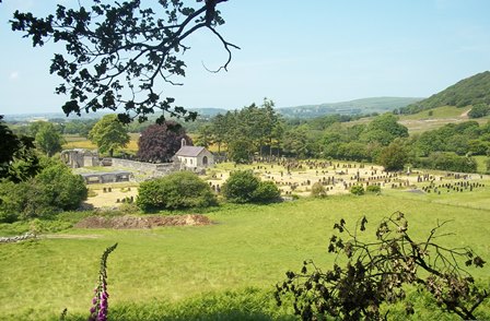
Turn right out of the car park and walk along the road to the entrance of St Mary’s Church cemetery. Enter the cemetery through the main lych-gate and take a look at the wooden display case on your right.
2 The last shepherd
Look at the display case on your right to find a plaque. It commemorates a donation of £120,000 for the upkeep of the cemetery by Mr Hugh Oliver Jones of Pantycraf, Tregaron.
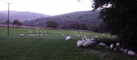
Hugh was born and raised at Dolgoch Farm in the upper Cwm Tywi Valley, around 10 miles southeast of here. In 1946, seven families lived in the valley and tended their flocks on the surrounding mountains – Tywi Fechan, Nantystalwyn, Dolgoch, Nantyrhwch, Bron-yr-Helm, Nant-Neuadd and Y Fanog.
In his book ‘Y Bugail Olaf’ (The Last Shepherd), Hugh recounts the transformation of the valley from sheep farming to tree farming. The trigger for this change was the winter of 1946/47. The snow lay so deep and for so long (throughout most of January, February and March) that combined with the resultant floods and the lack of fodder from the previous poor harvest, it led to the death of around 4 million sheep and lambs across the United Kingdom. The sheep in the upland hills and moors fared worst, accounting for around 75% of the total losses, including thousands in the Cwm Tywi Valley and the surrounding area.
The services of only 10 shearers were required in Dolgoch in 1947, compared with 85 shearers in the year before. Not a single ewe was sold from the Dolgoch Farm until 1952 as they tried to re-build their flocks from surviving sheep.
Following this financial and emotional blow and an offer to purchase their land from the Forestry Commission, each Cwm Tywi family gradually left their farmsteads. Hugh Jones and his family were the last to leave the valley in 1967.
Continue along the path veering to the left of the church. Stop when you reach the large yew tree on your left.
3 The poet and the prized ram
It is common to find large yew trees like this one in a churchyard. It might be because they’re considered sacred and may symbolise eternal life. But we’ve stopped here to commemorate a death.
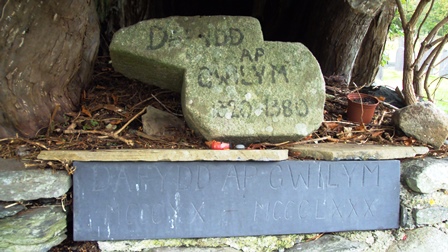
This tree is believed to mark the grave of Dafydd ap Gwilym, the most famous of Welsh medieval poets. Dafydd ap Gwilym from Ceredigion lived during the fourteenth century and may have died from the Black Death.
In addition to writing about love (particularly two ladies named Morfudd and Dyddgu!) and important people and events of the time, he took inspiration from nature.
His poems include Y Lleuad (The Moon), Y Seren (The Star), Y Don ar Afon Dyfi (The Wave on River Dyfi), Y Wawr (The Dawn), Yr Haf (The Summer), Y Rhew (The Frost/Ice), Y Niwl (The Fog/Mist) and Y Gwynt (The Wind).
Look inside the yew tree and you will notice that the trunk is hollow. This is where during the harsh winter of 1946/47 – the snowiest winter on record – the son of the nearby Abbey Farm found his father’s prized ‘Improved Welsh’ ram. The ram had died after entering the tree in search of food and shelter from the storm.
Incidentally, an unusual gravestone stands nearby. Stand with your back to the church and it is to the left of the tree – the headstone has a picture of a leg carved into it. A cart accident crushed the leg of local man Henry Hughes. After surviving an amputation he had his leg buried here and later emigrated to America!
Stand with your back to the church and facing the yew tree, follow the sunken path left leading away from the church towards the stone wall. Follow the wall to the left and stop under the trees where you’ll find a flat gravestone that reads ‘Unknown’.
4 Where princes also sleep
This simple gravestone might not look like much, but it tells an interesting story. The nearby village of Ffair Rhos (1½ miles north of here), though now a seemingly remote place, was once an important stopping point for drovers taking their livestock from Welsh farms over the border to markets in England.
Ffair Rhos has a long history of holding livestock fairs and local accounts tell of men singing ballads at the fair both for entertainment, and as a way to commemorate important events and to spread the latest news and gossip.
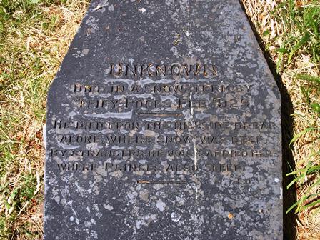
Later, a tradition developed of selling poetry to raise money for good causes. It began after the body of an unknown man was found at nearby Teifi Pools in February 1929. The man began his fateful journey east across the mountain but was caught in a snowstorm on the twelfth of January. When the thaw came in February and the snow melted, it revealed his body.
The man’s pockets contained only around 50 pence worth of old money, a photo of a young girl and a copy of Old Moore’s Almanac – a popular astrological almanac which has been published every year in Britain since 1697. The book gives predictions of astrological events, tide tables, sunsets and sunrises, eclipses and the weather for the upcoming year.
After the ballad ‘The Tramp’s Last Pillow’ appeared in the Welsh Gazette newspaper, copies were printed and sold and children would recite it to raise money. The money raised for this unknown man – thought to have been a veteran of the Second Afghan War (1878–80) – was used to lay him to rest here, at Strata Florida, and give him a gravestone that reads:
Exit the churchyard through the main gate you came in by. Turn left and walk as far as the next set of gates, which is the entrance to the Strata Florida Abbey.
5 The Vale of Flowers
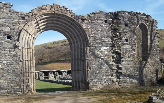
We are now stood at the entrance to the ruined twelfth century Cistercian Abbey of St Mary at Strata Florida. Strata Florida translates from Latin simply as ‘the Vale of Flowers’. It is called Ystrad Fflur in Welsh and Fflur (pronounced ‘Fleer’) is also the name of a nearby river.
The abbey held large estates in this area and specialised in sheep farming, owning large sheep pastures in the hills to the east. The original Abbey was established in 1164 along the river Fflur – approximately 2 miles southwest from here at a site known as Hen Fynachlog (‘old monastery’).
With the backing of Lord Rhys ap Gruffudd, the monks sought a more permanent location and in around 1201 moved here to a location nestled between the River Teifi to the north and the Glasffrwd (a tributary of the Teifi) to the south. This location was chosen to take advantage of the rivers and a series of channels, stone-lined ducts and lead pipes were built to bring water to the monastery.
The monks held wool fairs near the neighbouring village of Ffair Rhos and during the fourteenth century wool from the area was exported through Carmarthen to continental Europe. You might still be able to make out the ruins of the old ‘hafotai’ or summer homes of the shepherds who tended the abbey’s flocks, dotted across the mountain landscape.
The monks at Strata Florida were also responsible for compiling the manuscript that forms the basis for Brut y Tywysogion (or ‘Chronicle of the Princes’), one of the most important primary sources of Welsh history and now held in the National Library of Wales at Aberystwyth.
The remains of the Abbey (closed in 1539 by Henry VIII’s great Dissolution of the Monasteries), have never been entirely lost to view. It is now managed by Cadw, the Welsh Government’s historic environment service, who run an exhibition and gift shop at the entrance.
Entry to the Abbey is optional. If you are here between November and March or you are willing to pay the admission prices, please enter either through the gate or pay at the welcome desk to learn more about this cultural and religious centre of Wales.
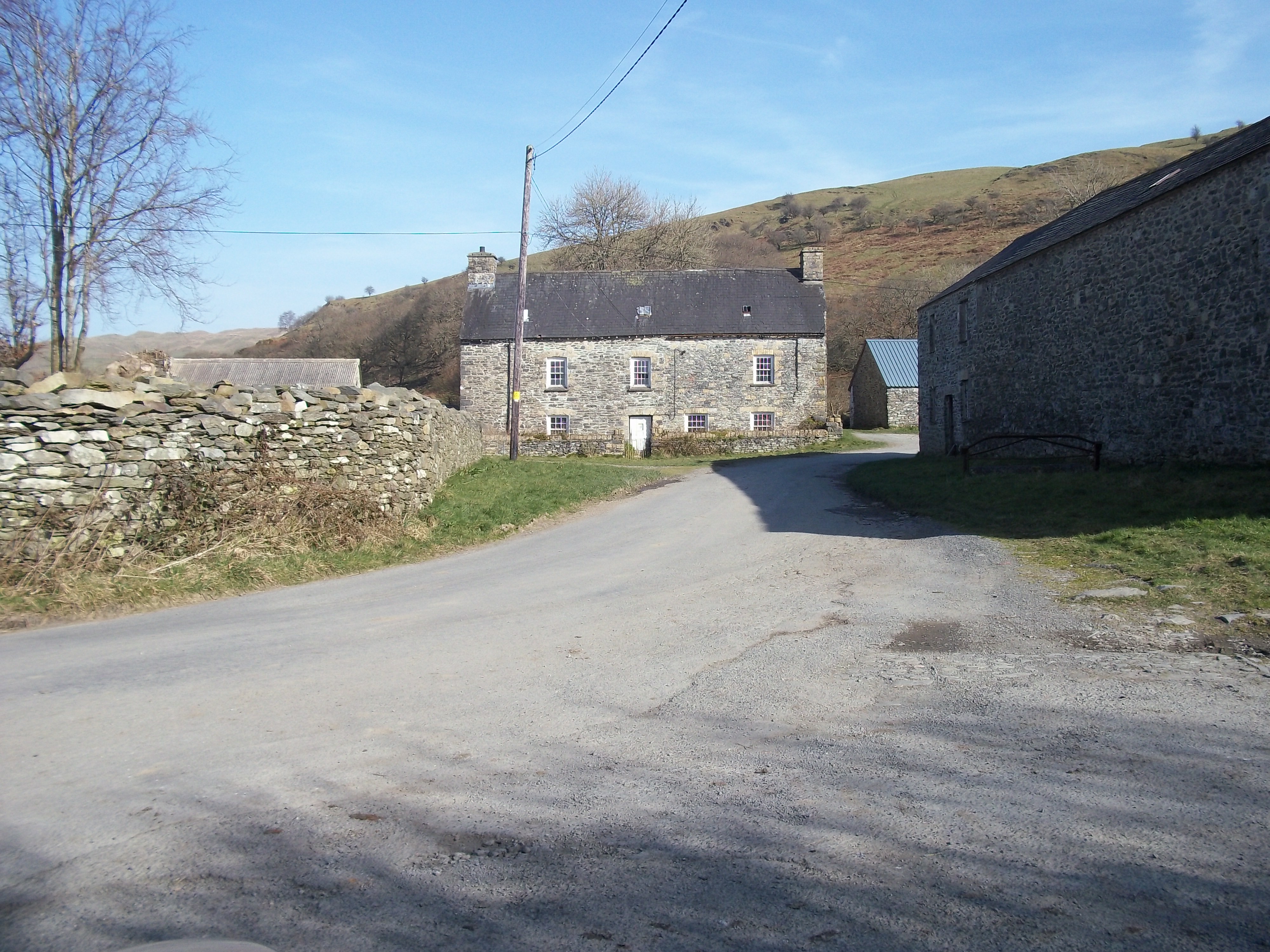
Either exit the Abbey complex or continue along the road towards the stone barn. Follow the road around to the left until you are facing the large stone house.
6 A preacher and a teacher
Ahead is the Mynachlog Fawr (which translates as ‘Great Abbey’) farmhouse. The current farmhouse, built of local stone, dates from the late seventeenth century built on the site where some of the abbey’s cloistral buildings once stood.
During the latter part of the eighteenth century John Wesley, the Anglican cleric who founded the Methodist movement, stayed here on numerous occasions while on his preaching tours.
Since 1850, Mynachlog Fawr has been under the ownership of the Arch family, who still farm the surrounding land today. One morning in February 1947, a young Charles Arch woke to see that his room was pitch black:
Charles: “I thought that I had woken much too early. I lay quietly on my back so as not to disturb anyone until I realised that there were voices coming from the kitchen. I lit the candle and tried to look out through the window. But I couldn’t see a thing. However, after dressing and opening my bedroom door I realised that the reason for the darkness was that the whole of the front of the house up to the roof was covered in snow!
In fact, there was such a mountain of drifted snow that the last patch was still there until the first week in June. I never saw such snow, with the cowshed nearly out of sight and there was no sign of the rickyard’s hedge or the gate that led to the small field.”
The Arch children were over the moon at the prospect of getting extra school holidays and not having to attend the nearby Strata Florida primary school (now the Abbey shop):
Charles: “The mile and a half road to the village was impossible to travel as it is lower than the fields and was full to the brim of the hedges with snow. That made me quite confident that there wouldn’t be school for a long time.
So I got quite a shock when, on Monday morning I was stood on top of the cart house steps looking towards the village, I saw three people coming towards me across the fields. I got even more of a shock when I realised that Miss Rees [the schoolteacher] was one of them.
She had recruited the help of two Council workers to help cut through the snow to the school. By lunchtime we were all back at school and Miss Rees concentrated on me and my scholarship exam in the spring to aim for the County School at Tregaron. From then on, she walked up from the village every day for over six weeks, until the road was cleared, dressed in a big long coat, wellingtons and a huge scarf around her head.”
Despite the wintry weather and thanks to Miss Rees’ determination, the children lost only a handful of days of school and Charles got his scholarship to attend Tregaron County School.
Carry on past the farmhouse, stopping just after a bend in the road by a telegraph pole and look up between the trees towards the crest of a hill where you should notice a figure ‘walking’ along the skyline.
7 Pilgrims progress
Look up to the left and see if you can make out a figure walking along the skyline. This is an outdoor sculpture commissioned as part of a Sculpture Cymru initiative to involve artists with the archaeological heritage of Strata Florida. This 14-foot (4-metre) high wooden figure entitled ‘Pilgrim’ was made by Glenn Morris from recycled oak and old railway sleepers.
The sculpture is inspired by the pilgrims that would have stopped at Strata Florida Abbey, probably on their way to St David’s on the southwestern tip of Wales between the twelfth and sixteenth centuries. This pilgrim appears to be heading in that direction – shoulders hunched as he battles against the southwesterly winds. The sculptor has said of his work “all of us are pilgrims in a sense, moving through our lives, looking for something”.
In more recent times, shepherds have been frequently seen walking these mountains. One of the most notable shepherds of the region was William Williams (1698–1773). He farmed large swathes of land during the eighteenth century, including Dolgoch in upper Cwm Tywi which we heard about at the start of the walk.
He was known as ‘King of the Mountain’ or ‘Job of the West’ as he owned almost 20,000 sheep, 500 mountain ponies and land in three counties. He lost a few thousand sheep during the 1772/73 winter and it’s thought locally that he died of the resultant heartbreak at 75 years of age.
Incidentally, the childhood home of another ‘King of the Mountain’ is to be found further along this road. Climber Caradog Jones was the first Welshman to reach the summit of Mount Everest, on 23 May 1995.
Continue up the road as it goes uphill and bends to the left, until you reach a bridle way sign pointing to the left. Go through the gate and follow the footpath through the ferns, keeping the fence on your left until you reach an information board by a low stone wall.
8 A floating railway
This wonderful view of the Abbey and the Teifi Valley is one not seen by most visitors.
The Abbey is visible to the left with St Mary’s church to the right, nestled in the bottom of the Teifi Valley. Beyond is the village of Pontrhydfendigaid and beyond that is Cors Caron – or Tregaron bog, the most intact surviving example of a raised bog in the UK.
Raised bogs emerge in low-lying areas where layers of peat build up. We will find out more about how they are formed later in the walk.
In 1866, this large geomorphological feature posed a challenge to the railway engineers of the Manchester and Milford railway whose route crossed the Tregaron bog. David Davies, an industrialist and engineer from Llandinam, devised plans to construct the railway on bales of wool and faggots of twigs. It is said that Davies bought up all the local farmers’ wool and used it to soak up the water. This allowed the railway to effectively ‘float’ across the bog.
By the end of August 1886, the line to Strata Florida was open. It could take passengers south to Carmarthen in 2¼ hours or north to Aberystwyth in under 1 hour. The line crossed the view ahead from left to right.
Strata Florida station was over to the right, near the village of Ystrad Meurig. It is not visible from here as the station, despite its name, was actually over two miles away from the Abbey.
When the Beeching Report was published in March 1963, it recommended the closure of the line between Carmarthen and Aberystwyth. So the passenger service officially ended on 22 February 1965. The disused railway line now forms part of the Ystwyth Trail, a 20-mile route that connects Tregaron with Aberystwyth. You can cycle or walk on it - or even horse ride along several sections.
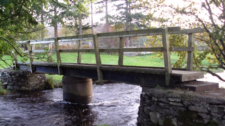
Continue along the path keeping the outer wall of the abbey on your left until you reach a fork in the path by a large oak tree. Follow the blue bridle way signs to the right until you rejoin a road via a bridleway gate. Turn left and walk along the road for about half a kilometre. You will reach a stile on the right by the cemetery wall. Climb over the stile and walk to the bridge on the right.
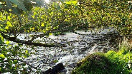
9 A stolen river
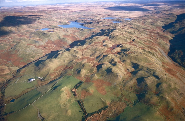
We are now directly over the Teifi, one of Ceredigion’s most picturesque rivers. Its source is a series of small glacial lakes - Llyn Teifi, Llyn Hir, Llyn Gorlan, and Llyn Egnant. These are known collectively as the Teifi Pools in the Cambrian Mountains about two miles northeast from here. The pools are worth a visit if you have time.
Though they are justly famous for high quality eel and trout fishing - and for providing drinking water for the surrounding area - the pools also tell an interesting geographical story about how this landscape was formed.
From its source, the Teifi flows for 76 miles (122 kilometres) to the sea at Cardigan, making it the longest river wholly in Wales. The river forms the eastern and southern boundary of the county of Ceredigion.
Evidence suggests however that the River Teifi was once much longer and extended another thirteen miles north as far the mountain of Pumlumon (‘Plynlimon’ in Welsh). Take a look at the diagrams on the next page, which should help explain the process that led to the river being shortened.
It is thought that the River Teifi was originally much longer, flowing from Plynlimon. Two separate rivers, the Ystwyth and the Rheidol were located to the west of it. Over time, the River Ystwyth eroded upstream and cut in to the Teifi Valley at Pontrhydygroes. The Ystwyth ‘stole’ the water that flowed in to the Teifi from Plynlimon in the north.
This made the Teifi shorter and changed the location of its source to the Teifi Pools. Later, the River Rheidol became the thief as, through the same process, it ‘stole’ the Ystwyth at Devil’s Bridge. This created the rivers and landforms we know today
If you visit the Teifi Pools you may notice large rocks or boulders strewn in the area. These are known as ‘erratics’ and were carried (perhaps hundreds of miles) by the same glaciers that formed these lakes and then deposited here. The erratics near Llyn Gorlan pool are particularly interesting as they stand in a rough circle.
After the bridge, head across the field towards the stile and cross over the fence. Walk for around 50 metres until you see a gap in the trees on your right. Look up towards the two disused stone buildings on the hillside.
10 Mining history
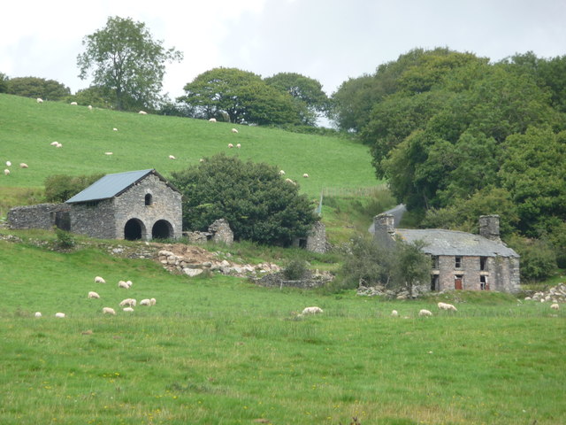
Looking at the OS map you willl see ‘Mine (dis)’ marked just north of the footpath. The two stone buildings you can see from here are disused mine buildings. They were part of the Bron-y-Berllan mining complex.
The monks at Strata Florida were required to be self-sufficient and create their own livelihoods. As well as being practiced farmers, they were also skilled at building, mining and quarrying. They were particularly noted for their expertise in the extraction and processing of metals - especially iron, lead and silver. The derelict buildings you now see are a part of the landscape of the lead mining industry.
Lead was mined in the area over two thousand years ago but little is known about its very early history. In 1690, a rich vein of lead ore was discovered at Esgair Mwyn, just over 2 miles northeast from here. A further vein was discovered in 1752. Along with Bron-y-Berllan, other mines opened at Glog-fawr and Glog-fach, Cwm-mawr, Twyn and Brynmwyn.
The village of Pontrhydfendigaid (whose name translates as ‘bridge at the holy ford’) was originally created by the Abbey to house the mineworkers on its nearby lands. It expanded in the nineteenth century during a boom in lead mining; many miners’ cottages from that period still survive, particularly along Terrace Road. The industry fluctuated, however, and by the early 1930s most of the mines had closed, although attempts were made to revive Esgair Mwyn in the early 1950s.
Follow the rough pathway along the Teifi River (following the walking route signs) over a stile. Head towards the corner of the fence on your right, noticing the face of a quarry on your right. Continue across the field keeping the river on your left and just left of the line of telegraph wires and mounds of stone. At the bottom of the field near a large tree cross over the stile into the next field. Cross over the next stile and notice the confluence of the rivers Teifi and Glasffrwd on your left. Follow the walking route signs over three more stiles, before stopping along the path when you are parallel to the white farmhouse and farm buildings on the hillside on your right.
11 One night houses and hill forts
At the last stop we saw the derelict landscape of the lead mining industry nestled in the hillside. The nineteenth century boom in mining transformed this area, creating whole new streets of houses for the mineworkers at Pontrhydfendigaid.
But there are other clues in this landscape which might point to the more primitive homes the miners first lived in. You might have spotted large jumbles of stones in the fields we just passed. These could potentially be the remains of a Ty Unnos (one-night house).
These were houses built on common land – usually illegally, unless the builder conformed to particular traditional customs. If they could build a house overnight and have smoke coming out of the chimney before dawn, the following morning, they could claim it as their home.
The amount of land they could claim depended on the distance the builder could throw his axe. Over time, the hovel was adapted in to a permanent home. These were particularly common during the nineteenth-century mining boom. Many were abandoned though when the mines closed and whole families moved to the South Wales coalfields in search of work. A local historian listed the ruins of 125 of these one-night houses in the Pontrhydfendigaid and Strata Florida area alone.
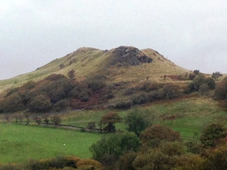
As well as the derelict lead mines you might be able to spot the remains of other past activities in this area. A number of Iron Age forts were built on the surrounding hills by chiefs and petty chiefs to rule over the farming population.
Find the white farmhouse ahead and then look up to see the three-peaked mountain above it. This is Pen y Bannau, an Iron Age hill fort. You can see why it was built here with commanding views across the valley.
Now turn back in the direction of the path ahead - the area of raised land in the distance is Y Gaer hill fort, an oval enclosure on rising ground in the north of Cors Caron.
Like many of these hill forts, their names on the maps are often all that remain. ‘C/Gaer (fort)’ and ‘C/ Garn (cairn)’ are often found on the map as names of present-day hills and farmhouses surrounding the raised bog at Cors Caron.
Head diagonally across the field along an opening between the rushes. Climb a stile to the road, turn left and walk to the village of Pontrhydfendigaid, crossing Nant y Cwn (The Dogs’ Stream) by The Black Lion pub. Turn right on the main road (B4343) and walk 5 metres until you get to ‘Strata House’ on your right.
12 The first post
We are now in the heart of Pontrhydfendigaid opposite Strata House. We have stopped here to see the birthplace of Welsh broadcaster, John Meredith. He was brought into the world at the start of 1947 and the snowdrifts of the snowiest winter on record gave him quite a story to his arrival.
He recalled: “Apparently the drifts were at their peak at that time. And people had to come in through the upstairs window to help Mum to give birth to me.”
One of the neighbours who came to help was the lady who delivered the post to the village. “She would always remind me – “I saw your belly button first” – as she had cut the cord. I would always say that I was delivered with the post – the first post!”
Another act of kindness was shown towards a lost sheep that had walked through the snow to Pontrhydfendigaid from the Upper Tywi Valley, approximately seven miles away. The sheep was taken in by a lady who delivered the post to Ffair Rhos.
It was reported in a local newspaper that the sheep was spotted following the lady through the village. Despite the grim weather conditions and rationing of the time, the sheep was cared for and fed until the thaw came and it was able to fend for itself.
Facing Strata House, turn right and walk along Bridge Street (on the pavement where possible). When you get to the main bridge just past the Red Lion Hotel, cross the grass to the riverside area near the picnic bench.
13 Boggy botany
As you walk through the village notice that many of the houses along this road include Teifi, Afon (river) or Nant (stream) in their names, reflecting their proximity to the river. We are about to cross the River Teifi for the second time but notice it has grown in width and power since we last crossed back at the wooden bridge near the church.
On its way to Cardigan Bay where it empties into the Irish Sea, the Teifi flows through the market town of Tregaron, but not before winding its way through Cors Caron – or Tregaron Bog.
The bog is the remains of a lake, fed by the River Teifi, which formed behind a mound of soil and rock pushed in front of a body of ice (known as a moraine). The moraine was left as the ice melted at the end of the last Ice Age (over 10,000 years ago) forming a lake. The lake overflowed the moraine at its lowest point and, over time, carved a channel through it – lowering the level of the lake. This combination of drainage and the formation of layers of peat created the present raised bog – the largest of its kind in the UK.
The layers of peat formed in this large expanse of raised bog were a source of fuel for surrounding villages, including Pontrhydfendigaid. Peat cutting still took place on Cors Caron until 1955, when it was designated a National Nature Reserve.
Cors Caron is now a Site of Special Scientific Interest (SSSI), a Special Area of Conservation (SAC) and a wetland of international importance (Ramsar site). It is managed by Natural Resources Wales and is a haven for wildlife and visitors alike.
Dragonflies, lizards, otters, hen harriers, curlews and skylarks are among the species that can be seen there. Also keep an eye out for a Red kite which, since 1903, has been the subject of the longest-running bird conservation project in the world.
In the 1930s, this species was extinct in the UK apart from the remote valleys of mid Wales, where it is thought that less than a dozen individuals and a couple of breeding pairs had survived. It has since been proven that, in 1977, the entire UK population had emanated from one single female.
This once globally threatened species has become a success story of wildlife management; a series of feeding centres, nest protection and reintroduction initiatives have seen numbers increase. Their hovering silhouettes with forked tails have become a familiar sight in the skies of mid and west Wales and beyond. Kites from Wales have even been used to reintroduce the species to Northern Ireland. To find out more you can visit the Tregaron Kite Centre.
Other remarkable creatures were once spotted in this wild place. Since the 1970s there have been reported sightings of a large cat-like animal – dubbed the ‘Beast of Bont’ – roaming the area.
Cross the bridge, being careful of traffic at all times, and notice the initials carved into the stone by generations of local children. Continue walking along Bridge Street for 100 metres until you reach a junction with a large yellow house on your right next to the post office. Look up to see the mural on the gable end wall of the house.
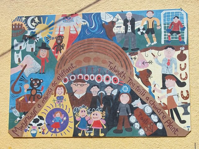
14 Miners, monkeys and elephants
This mural was created by local children as part of a project to raise awareness of the history, traditions and heritage of the area within the local community. It is a good place to stop and summarise what we have learnt about the Teifi Valley on this walk.
We heard earlier about the long history of mining in this area and how people made their livelihood from the land. See if you can spot a reference to the ‘tai unnos’ (one-night houses), in the top left-hand corner of the mural (notice the smoking chimney and the axe).
Some of the more permanent lead miners’ houses stand just behind us along Terrace Road - look out for the colourful terraced row.
See too if you can spot an elephant in the mural. It arrived in the nearby town of Tregaron with Batty’s travelling circus in 1845. Legend has it that the elephant died and was buried behind the Talbot Hotel in Tregaron. Its remains have yet to be discovered, despite archaeological investigation!
The bottom left-hand corner represents the late Dai Rogers, who kept a monkey called Jimmy and used what was later identified as a Second World War bomb as a doorstop!
Other mysterious traditions and tales of the area are represented too. According to Welsh folklore, fairies live on the bog of Cors Caron. If you happen to see a phantom funeral (known as a ‘toili’), it means a real funeral will soon take place! In the mural, the seer of the ‘toili’ has a corpse candle (‘cannwyll corff’) above his head and sees one of the ‘Cwn Annwn’ (spectral hounds of Annwn, the otherworldly paradise of Welsh myth) – both considered to be signs of an imminent death.
We hope you have enjoyed the stunning Teifi Valley and have begun to understand as well as just admire this landscape. Along the way we have found out how this area has been shaped by both human and natural influences including the snowiest winter on record, still remembered locally as the ‘big snow’.
We began the walk at the site of the Strata Florida Abbey where we heard some of the human stories about the people who lived, worked and died in this area.
On the banks of the River Teifi we learnt how this valley in the Cambrian Mountains was shaped by the dramatic movement of rivers and ice. We’ve seen evidence of local mining industries, spied iron-age hill forts and found a small village at a river crossing with many stories to tell.
Facing the mural, turn right and follow the sign for the abbey. Walk the Abbey Road – along the River Teifi – back towards the car park at Coed Dolgoed to complete the walk.
Your browser is out of date, and unsupported by this website. Please upgrade to the latest version to use this website.
The lush Teifi Valley nestles within the Cambrian Mountains, a remote and unspoilt area of mid Wales. Lying between Snowdonia and the Brecon Beacons, the Cambrians are the source of several Welsh rivers - including the Teifi.
This walk explores the valley carved out by the River Teifi and home to the dramatic ruins of Strata Florida Abbey. The Abbey has dominated this landscape for centuries, drawing pilgrims from far and wide.
Make your own pilgrimage to the Teifi Valley and find the area's hidden stories. Discover Iron Age hill forts, ‘one night houses', and a miraculous floating railway across a dangerous bog.
Follow the walk by clicking on the map pins or downloading the guides below
Dr Cerys Jones of Aberystwyth University for creating this walk, providing photos and the audio
Georgina Endfield and Juliette Cross from University of Nottingham for development, testing and their work on the wider project
Caroline Millar and Rory Walsh for editing the walk materials and providing photos
Rhys Davies and Gareth Lloyd for providing additional audio
Antony Smith (Department of Geography and Earth Sciences, Aberystwyth University) for producing the maps
Archifdy Ceredigion Archives, Cambrian News, Carmarthen Journal, National Library of Wales, University of Wales Trinity St David and the Royal Commission on the Ancient and Historical Monuments of Wales for permission to reproduce images from their collections
Glenn Morris for photos of his Pilgrim sculpture
Other images reproduced under Creative Commons Licenses
The Arts and Humanities Research Council (AHRC) for funding the wider project “Snow Scenes: exploring the role of place in weather memories” (ref. AH/L50354X/1), part of the Enhancing the Role of Arts and Humanities on Environmental Values and Change scheme
.jpg)