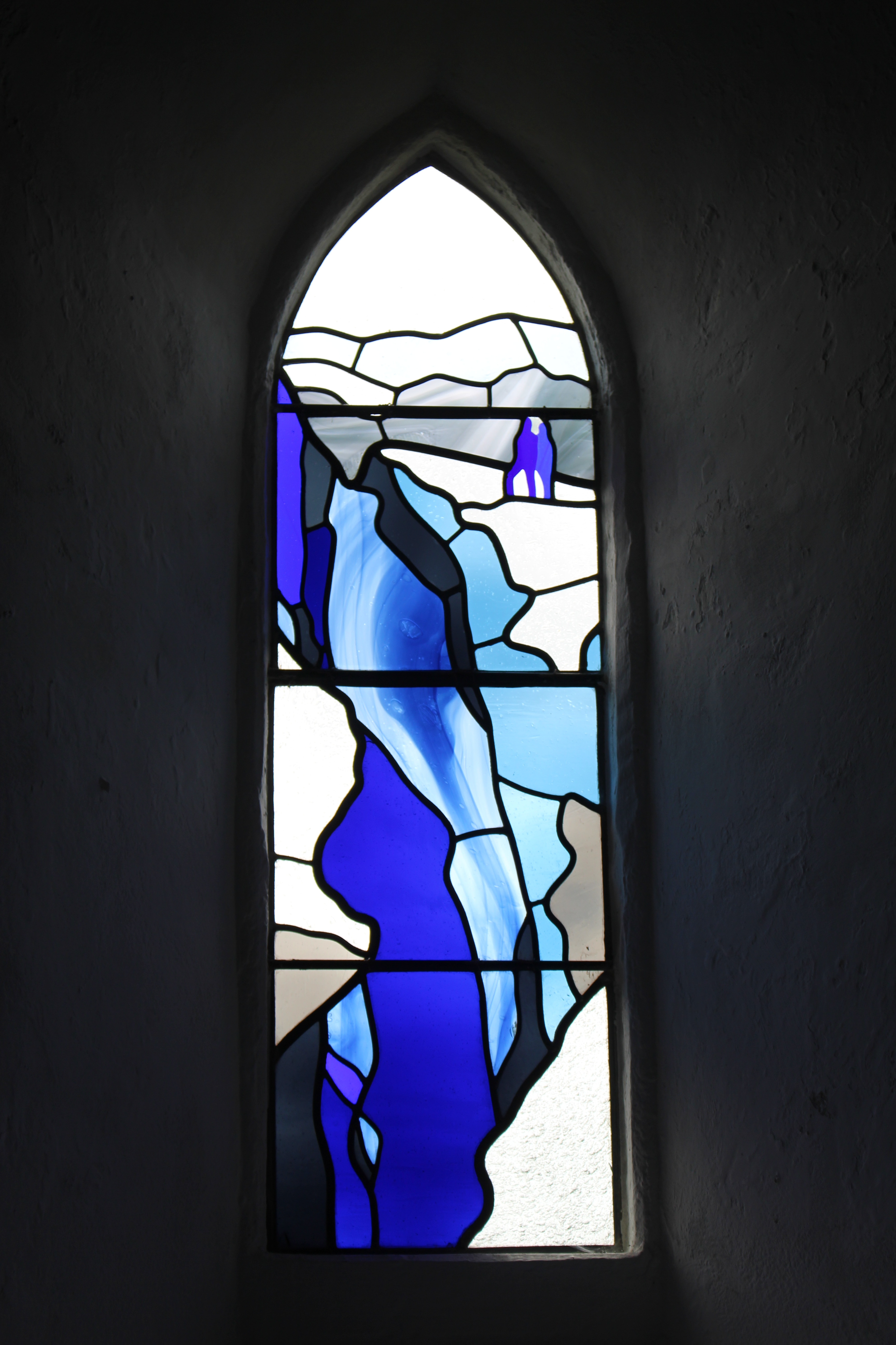
You might not make an immediate connection between Rhossili and the Antarctic (except on a very cold day!) but inside this church we can find one. Go in and look for a blue and white stained glass window, showing a glacier with figures on top.
The window and the nearby plaque are memorials to local-born Edgar Evans. Evans was one of the men who died on Captain Scott’s ill-fated Antarctic expedition of 1910-1913. The Antarctic scenery depicted here is only the first spectacular view we will see on our walk.
St Mary’s Church stands at the start of the footpath up the south side of Rhossili Down. The Down is the highest of the sandstone ridges which rise across the Gower peninsula. Let’s begin our own exploration…
Directions
When you are ready, leave the church. From the car park turn left. Go down the track and make for steps ahead leading uphill. Go through gate labelled ‘Rhossili Down’ and continue up the steps to a flattish area. Take time to enjoy the great views. Walk between some gorse bushes to the top of the hill. Stop when you reach a white trig point.
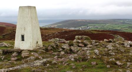
2 Trig point, Rhossili Down
We’ve only climbed a short distance but already we have a wonderful 360-degree view across the whole of the Gower peninsula.
From here we can start to see what makes this unspoilt thumb of land jutting out into the Bristol Channel unique. For a relatively small area - approximately 70 square miles - the Gower boasts a huge variety of different landscapes and habitats. Described as “a happy accident of geological forces, climactic conditions and human enterprise”, this is a place of contrasts.
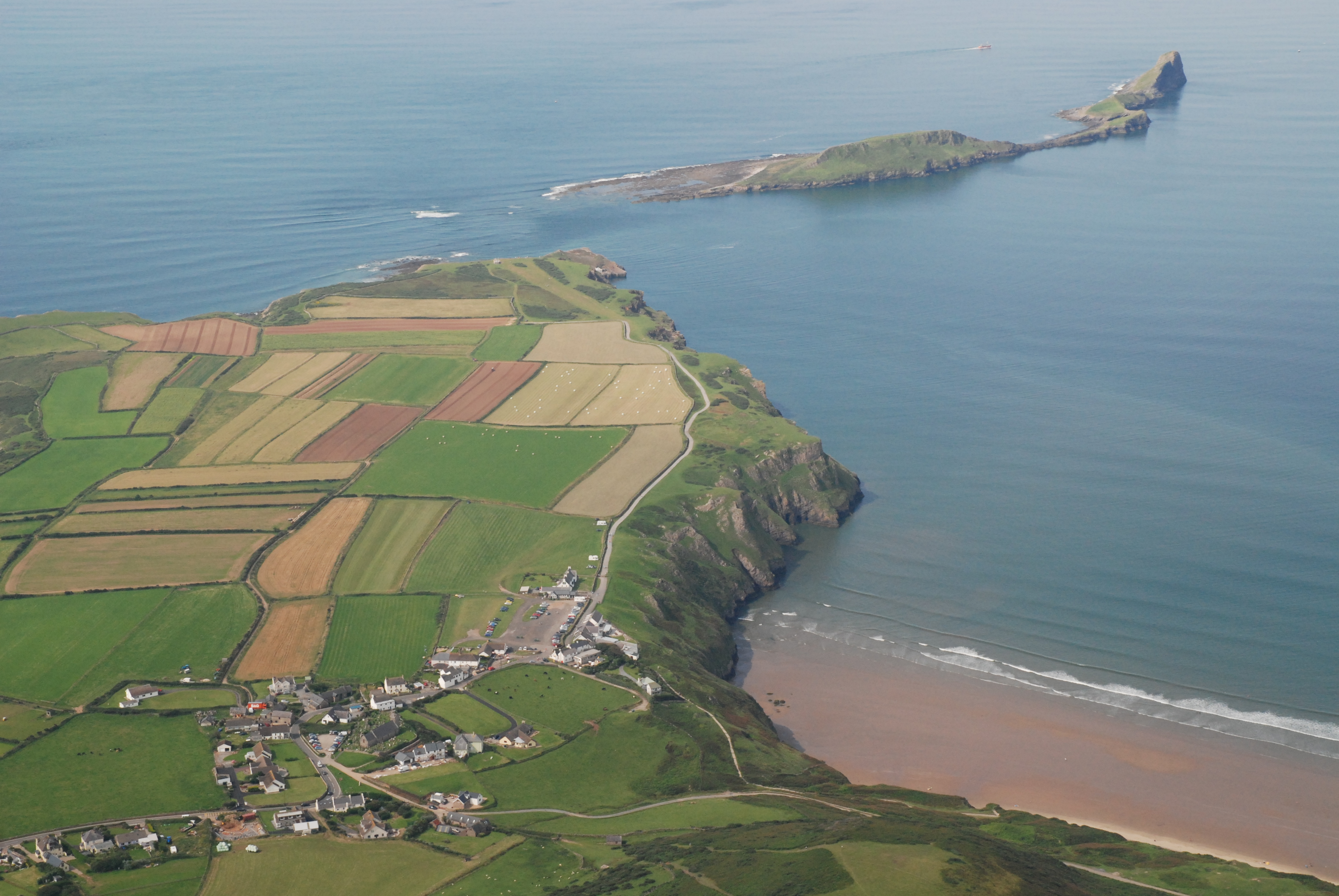
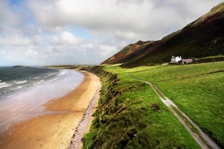
First, take in the pristine golden sands of Rhossili beach, stretching away from us for 3-miles. On the landward side are an impressive network of sand dunes, created over 500 years by sea storms.
At either end of the beach are two tidal islands: Worm's Head (to our left) and Burry Holms (to our right). Attached to the mainland by slim umbilical cords of rock, they are cut off by the tide twice a day. Reaching them poses a risk (and challenge) to would-be adventurers.
Look to the left and inland from Worm's Head. Can you can spot a patchwork of fields? This area, known as The Vile, is one of the few places in Britain where arable farming is still practiced using the medieval 'open field' system. The land is divided into long thin strips, marked out by earth banks and drystone walls.
The system divided the land equally so villagers could share out the good and poor quality soils. Today, the land is still rented out to local farmers. Like many parts of Britain, the harsh economic realities of farming mean it is sadly in decline. But here on the Gower farming is essential for maintaining the character of the AONB.
Below us, the flat apron of land above the beach is known as the Warren. The original Rhossili village was once located here, but it has long been deserted and now lies buried under layers of sand. It’s said though that the bells of the old village church can sometimes be heard ringing...
The poet Dylan Thomas, who was born in nearby Swansea, spent much of his youth on the Gower peninsula. See if you can spot a lone white house on the Warren. Thomas almost bought it but decided not to as there was no pub in the village!
Meanwhile, the high sandstone ridge of Rhossili Down that we’re on offers a completely different landscape to the beach below. From our vantage point here we can see the Gower’s other high ridges of land, including Hardings Down and Llanmadoc Hill. Beyond Llanmadoc Hill on the north coast are miles of saltmarsh and dunes, grazed by cattle and wild ponies.
Directions
Retrace your steps for a short distance then take a path bearing left across the heathland in an East South East (ESE) direction. Stop a little way along it.
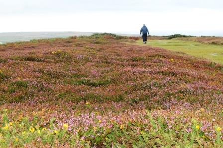
3 Heathland, Rhossili Down
We’re now walking across Rhossili Down. Compared to the patchwork of neatly hedged fields we can see ahead, this scrubland might seem a bare and unproductive landscape. But this is a rare heathland habitat.
The thin soils on this rocky, sandstone ridge don’t allow for much vertical growth. Yet look around for low-lying shrubs and plants, including gorse, heather and bracken. If you’re lucky enough to be here in September, the peninsula is a riot of red and purple as the heather comes into bloom.
Heaths are also home to rare insects, including the black bog ant and damselfly. You’ll probably see (and hear) skylarks rising from the heather and perhaps a brown hare turning tail at our approach.
Also watch for wild horses roaming the heath. Besides adding interest to the scenery, the horses play an important role in maintaining it. By nibbling the encroaching scrub and bracken they keep these plants from taking over the land and smothering other wildlife.
In just 200 years the UK has lost 85 per cent of its heathland - through building, forest plantations and neglect. As a result, these Gower habitats have become even more significant.
Directions
Keep following the broad track downhill across the heath, following the blue arrows towards a house. Follow the path as it bends around the house and meets a road.
After a short distance cross a stile behind a Gower Way marker. Follow the yellow arrows, then cross another stile and turn right down a track through the village of Pitton. Follow this to the main road.
Cross the road and follow the lane to Mewslade Beach car park. Follow the footpath sign between two sheds down to Mewslade Bay. After a wooded area, go through a wooden gate near a National Trust sign to reach the bay itself.
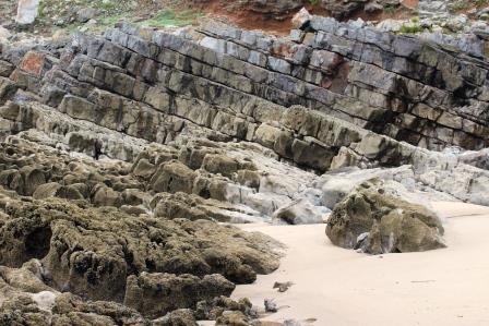
4 Mewslade Bay
Unlike Rhossili beach, Mewslade Bay is much remoter and unpopulated. The nearest car park is over half a mile away and the path descends through a narrowly cut valley. Enjoy the isolation, the drama of the setting and the crashing waves hitting the shore.
Mewslade has a strange sense of other-worldliness. It looks a little like a set from Star Trek or how we might imagine the surface of another planet. That’s chiefly down to the strange shapes made by the rocks. Besides enjoying the peace and solitude of this secret beach, we can read the history of the landscape by looking around.
At the lowest level, closest to the sea, are smooth potholes in the rocks. They are created by the swirl of the tides, as waves bring boulders up to the beach. Just above this level, we can see how the rock is ‘soluble’, which means it dissolves in water. The limestone has been nibbled by sea spray and rain - creating pits, meanders, and pinnacles in the rock.
Moving up beyond the reach of the waves, can you spot orange lichens growing? This zone is where small plants, like thrift, are able to colonise the rock surface. At this level that we can also see an irregular platform above the reach of the sea. This is a clue that sea levels were once much higher – this platform was once the original beach.
Look closely for clusters of round boulders and cobbles. They were left behind by the waves lapping at this higher shoreline. This feature is known as a ‘raised beach’. There are many of them around the Gower's coast.
Today Mewslade Bay is protected by a great limestone headland, Thurba Head. It acts as a bastion, defending the beach from the power of the waves.
Directions
Retrace your steps up the narrow rocky footpath. When you see a path going diagonally uphill on the left, take this and follow it along the Wales Coast Path. Continue along the Wales Coast Path, past Fall Bay, until you reach the coastguard station at Worm's Head. With your back to the hut look out to sea at the headland.
5 Coastguard lookout hut, Worm's Head
The extraordinary-shaped rock jutting out into the Bristol Channel is known as Worm’s Head. Look at its shape - what does it look like to you?
Worm’s Head was named by Viking invaders, from the Norse ‘wurm’ meaning 'dragon'. The headland does rather resemble a sleeping dragon with its back and head poking out of the water.
Worm's Head is a tidal island, so depending on the time of day it can be completely cut off from the mainland. It’s possible to walk across to it but it’s quite a tough scramble in places. If you are planning to go onto Worm’s Head, always use the safe crossing times. You can check these with the coastguards here at the lookout station.
A visitor who did get stuck on Worm’s Head was Dylan Thomas, who fell asleep on the island and was stranded there until the tides changed. He later wrote: “I stayed on that Worm from dusk to midnight, sitting on that top grass, frightened to go further in because of the rats and because of things I am ashamed to be frightened of. Then the tips of the reef began to poke out of the water and, perilously, I climbed along them to the shore.”
The flat causeway that tempts explorers also provides clues to why Worm's Head became a tidal island. Look along it for ‘faults’ (cracks) in the rock filled with bands of white. The white stripes are made of a mineral called calcite. Calcite is easily eroded, so over time, the waves have eaten away at the rock, leaving this low apron of land as a natural causeway.
Directions
With the sea on your left, follow the Wales Coast Path back to Rhossili village. Stop when you reach a bumpy area of grass to the left of the path.
6 Wales Coast Path to Rhossili village
Walking back to the small village of Rhossili, once again we can enjoy glorious views over the wide sweep of the beach and peninsula beyond. But notice the bumpy area of grass to the left of the path. They are the remains of a fort dating back to around 700 BC.
From this elevated position, we can see why our warring ancestors might have chosen this spot to watch out for approaching enemies. The remains of the fort’s raised bank are just visible but it’s thought that much of the earthworks were destroyed by later limestone quarrying. Limestone from this area was transported by boat to Exmoor in north Devon to convert the moorland to pasture.
Look at a map or investigate the Gower further and you’ll find a wealth of prehistoric, Bronze Age and Iron Age sites. They include forts, burial chambers, standing stones and cairns. This rich archaeological and built heritage adds to the Gower’s magnetism and allure.
As we return to Rhossili village, notice its size. There’s little more than a hotel, café, gift shops and a few houses. As an AONB, the Gower is protected from inappropriate development. The small population centres that dot the peninsula are few and far between. As a result, it has become a magnet for visitors wishing to escape the clamour of modern life.
Tourism is now the Gower’s most important industry. Besides boosting the local economy, this also raises issues of sustainability. Tiny villages like Rhossili can become swamped with summer visitors. Narrow country lanes are sometimes clogged up with traffic, while beaches and popular beauty spots can become littered. Summer businesses, like surfing shops and campsites, struggle in the winter. Houses have become holiday homes, leaving villages empty out of season.
The Gower, however, really is a year-round place. Each season offers a different beauty. The ‘happy accident’ of a stunning natural coastline and diverse habitats are both a strength and weakness on this “rare patch of the earth’s surface”.
Directions
From the village you can make your way back to the church where the walk began.
Your browser is out of date, and unsupported by this website. Please upgrade to the latest version to use this website.
West of the city and industries of Swansea and Port Talbot lies a small headland home to some of the most beautiful scenery in Britain - the Gower peninsula.
In 1956 Gower’s stunning limestone coast and variety of different habitats meant it was designated the UK’s first ever Area of Outstanding Natural Beauty (AONB).
In just five miles, we’ll experience some of these different landscapes – from golden beaches to windswept heaths, wave-carved bays to tiny, unspoilt farms and villages - and find out why it has this special status.
Follow the walk by clicking on the map pins or downloading the guides below