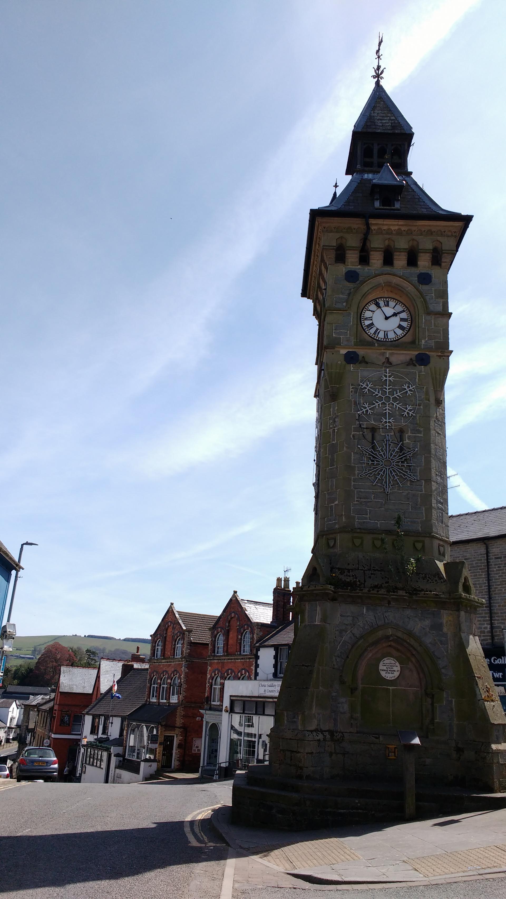
This Victorian clock tower might seem a strange place to start a walk about one of Britain’s most extraordinary ancient monuments. But it’s the tower’s location not the clock itself that brings us here.
Although officially a Welsh town, Knighton straddles the border into England. Its Welsh name, Tref-y-clawdd, means ‘Town on the dyke’. This is our first clue that we are by an ancient border between two nations, two languages, and two cultures.
Before Wales and England existed as we know them today, the land was contested among several tribes. Offa’s Dyke was built on the instructions of an English tribal king, Offa of Mercia. During Offa’s rule, around 757-796 AD, Mercia covered the middle and south of what is now England.
Today Offa’s Dyke looks like a grassy wall and deep ditch. But it has far greater significance. The dyke was a symbolic and physical barrier, built to defend Mercia from neighbouring Welsh tribes. It runs almost the whole length of the Welsh/English border - from the Dee Estuary in the north to the Severn Estuary in the south.
We may never know for sure whether the line Offa drew between England and Wales created the national boundaries that still remain to this day. But it certainly put this small town on the map. Knighton lies almost halfway along the dyke and is now home to the official Offa’s Dyke Centre.
Directions
With the clock tower behind you bear left and go downhill along West Street. Turn right through the archway in the Knighton Hotel and into the car park.
Bear left through the car park and climb the road ahead (Larkey Lane). At the top carefully cross over the main road to join Ffrydd Terrace Turn right and immediately left between the houses. Turn right again in front of a row of garages. When you reach the right-hand end of these, cross the stile and walk up the path towards the woods.
Cross a surfaced lane and continue up the woodland path to another stile. The dyke bank will be on your right. Cross the stile and bear right, climbing with the edge of the wood below you to your right. The Knighton golf course is now on your left.
At its end go over the stile and continue along the right hand edge of three further fields with stiles in between each. In the fourth field a prominent stretch of the dyke is reached. Go right over a stile and stop here.
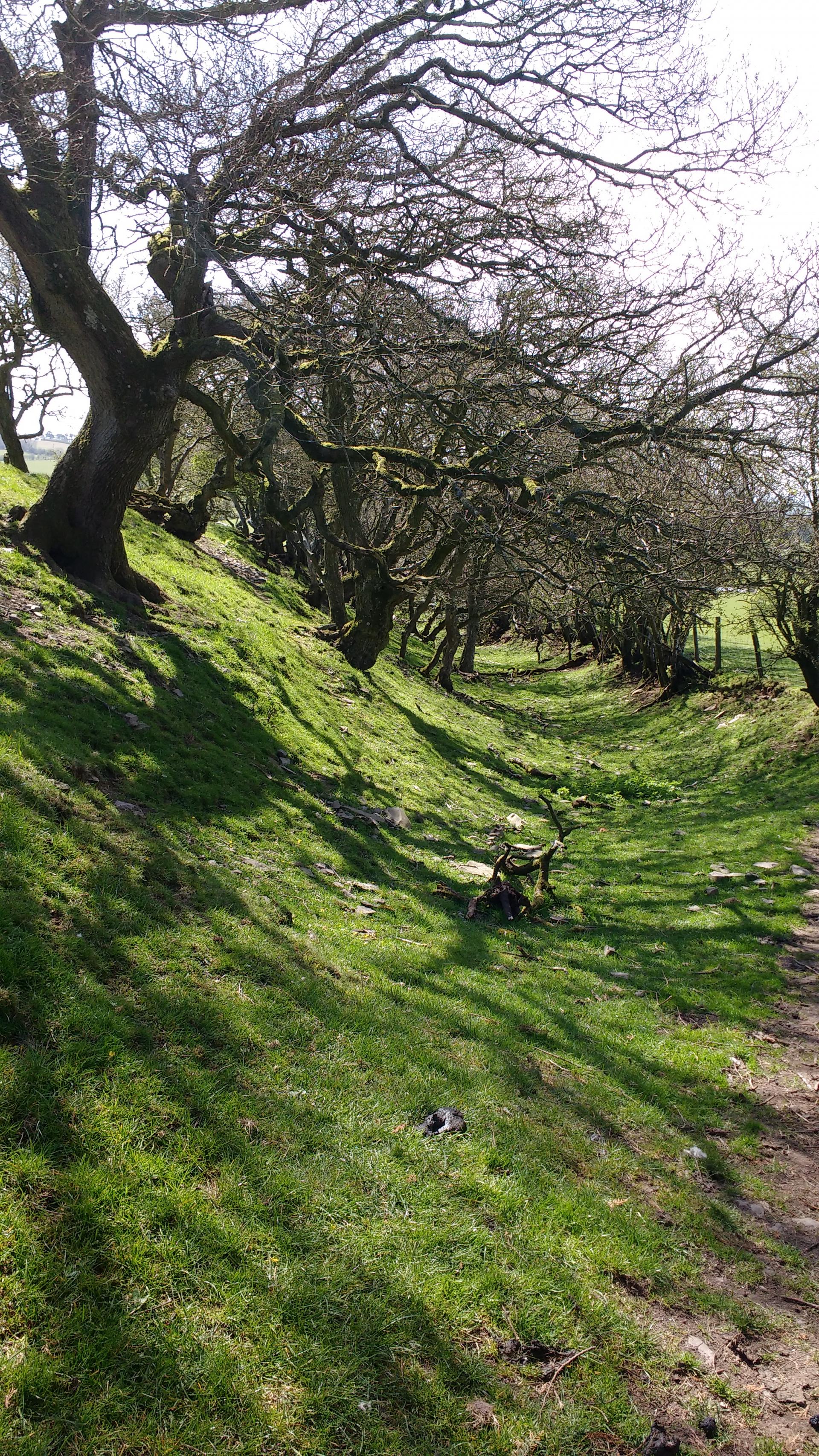
2 Offa's Dyke
At this point we get our first clear glimpse of Offa’s Dyke as it rises from the ground to our left as a sturdy grass wall. We have been following its course, however, since we left Knighton town centre. So far the Dyke has barely dipped in and out of view, so don’t be disappointed if you hadn’t noticed it until now.
Take in the Dyke’s appearance here. Offa’s Dyke is 70 miles long and can reach as high as 8 metres in places. Its route would have been carefully surveyed and laid out to exploit the natural contours of the land. At this spot we are shielded from the neighbouring field and the ground dips away steeply into a gully (ditch). This landscape is one of the greatest clues to why the dyke was built.
Offa was a formidable character, keen to preserve his kingdom of Mercia. Coins he minted often depict him as a Romanesque ruler or dripping in jewels. The Romans had left Britain some 300 years before Offa came to power but he was still influenced by their legacy.
Besides military might, the Romans ruled over Britain through changing its culture. British tribes were encouraged to adopt Roman clothes, customs and living conditions. For the Romans this was a way to assert their authority (and expand the empire). It also helped keep the tribes onside by showing what they stood to gain from Roman rule.
So Offa may have built the dyke as another way to show off his prowess as a leader - and to signal his dominance over the landscape. The ditch we are now standing in, however, is prominent on this side of the grassy mound throughout the Dyke’s course. This suggests it may also have been designed to defend Mercia from attackers from the west – namely the Welsh.
Though no written records of its construction exist, building the dyke would have been an arduous task of quarrying, digging, mounding and mapping. The amount of earth dug out and moved must have tested the endurance of the very strongest of builders. And all within a challenging landscape of moorlands, forests, valleys and hilltops.
Offa’s supremacy over Mercia would have been reinforced by any means possible. One way was to demand military service from his subjects. This was probably how Offa managed to get so many hands to help build the dyke. That it still stands today is a reminder of the extraordinary feat of engineering and muscle power it was.
Directions
Continue down the slope of the dyke, keeping it to your left. Continue through three fields. When you reach the end of the third, a hedgerow marks the boundary with the next field. There is a way-mark arrow within this hedge. Turn right with the hedge on your left and follow it to the edge of the field and a small road.
Join the road and turn right to turn back towards the direction of Knighton. Stop here and look back over the field towards the dyke.
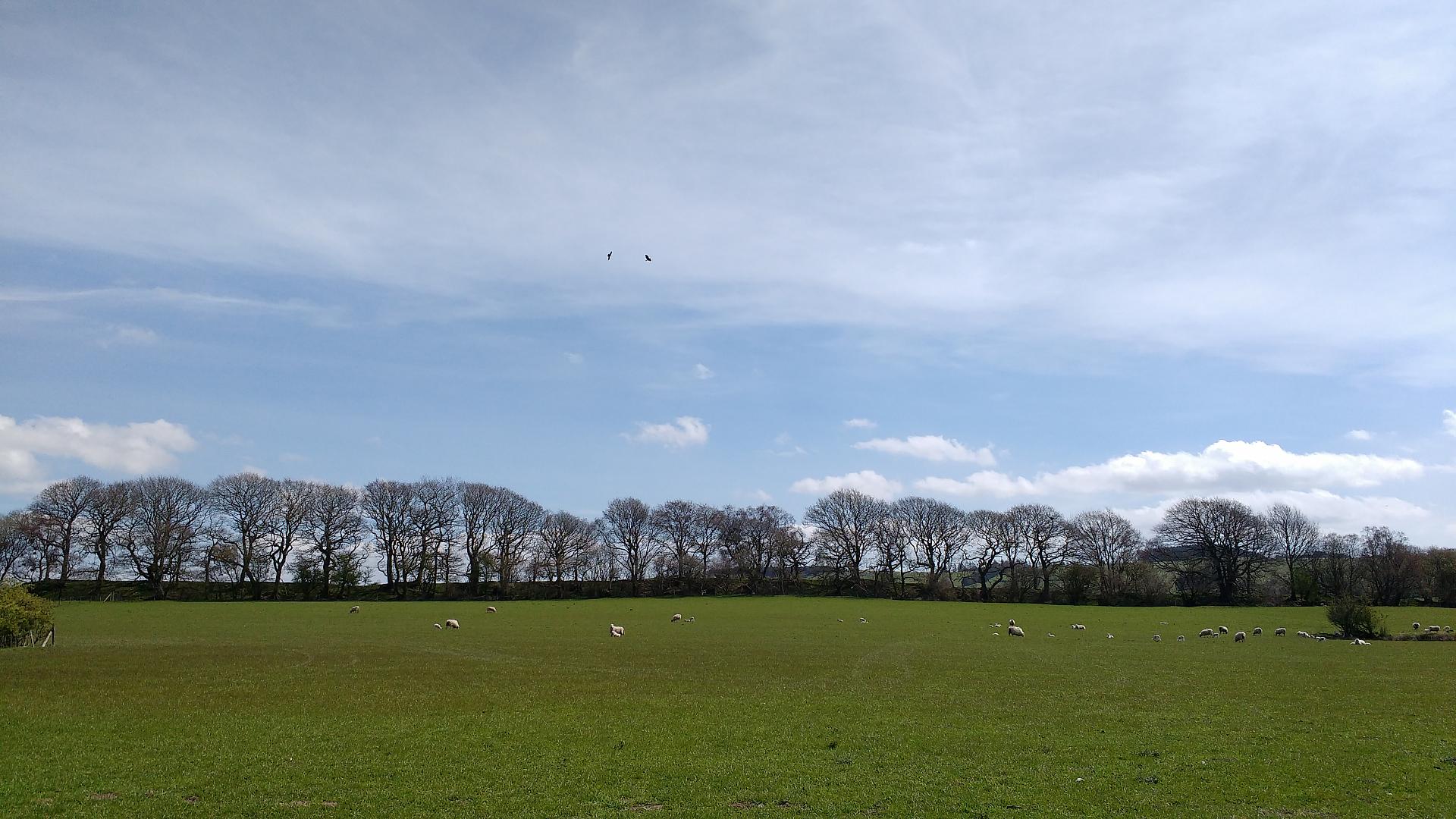
3 Offa's Dyke treeline view
We have now left the official Offa’s Dyke Trail but by moving across this field we can turn back to see the dyke within the landscape. Notice it appears as a line marked by a ridge of trees. Besides creating a pleasing view, the trees provide an easy way to spot the dyke’s route.
The trees themselves tell an important part of the dyke’s story. Though it’s unlikely they were part of Offa’s original plan, it’s no accident that they are here.
Around Knighton many of the trees lining the dyke’s route are conifers, especially Larch and Scots Pine. These species are useful clues to when and why they were planted. Neither Larch nor Scots Pine are common locally - or even native to England. This suggests that they were deliberately planted.
In the seventeenth and eighteenth centuries it seems to have been common practice to plant trees on top of ancient earthworks. Nobody really knows why. It may have been to mark them out as landscape features or to show who owned the land.
A famous example is Chanctonbury Ring on the South Downs in Sussex. In 1760 a wealthy landowner, Charles Goring, decided to top the burial mound with beech trees. There was local opposition at the time but the trees eventually became an icon of the site. When the storm of 1987 blew most of Chanctonbury’s trees down, the idea of leaving the hilltop bereft was met with uproar and there was a massive effort to replant them!
Today, however, the practice is prohibited on Scheduled Ancient Monuments. Along Offa’s Dyke there are examples where tree roots are starting to pull away at the land and damaging the monument beneath them. So although the trees help to illustrate Offa’s ancient boundary, if any of them were lost they would not be replaced.
Directions
Continue along the quiet road, past Upper Woodhouse Farm and up to a junction with another road (the A488). Cross over the A488 and bear left to join Penybont Road – then almost immediately, turn right to go down Mill Road.
Follow Mill Road until you reach a fork. Take the right hand fork that runs almost parallel to Mill Road above. Continue to a set of metal railings next to a river on your right, just after a wood-clad building. Stop here.
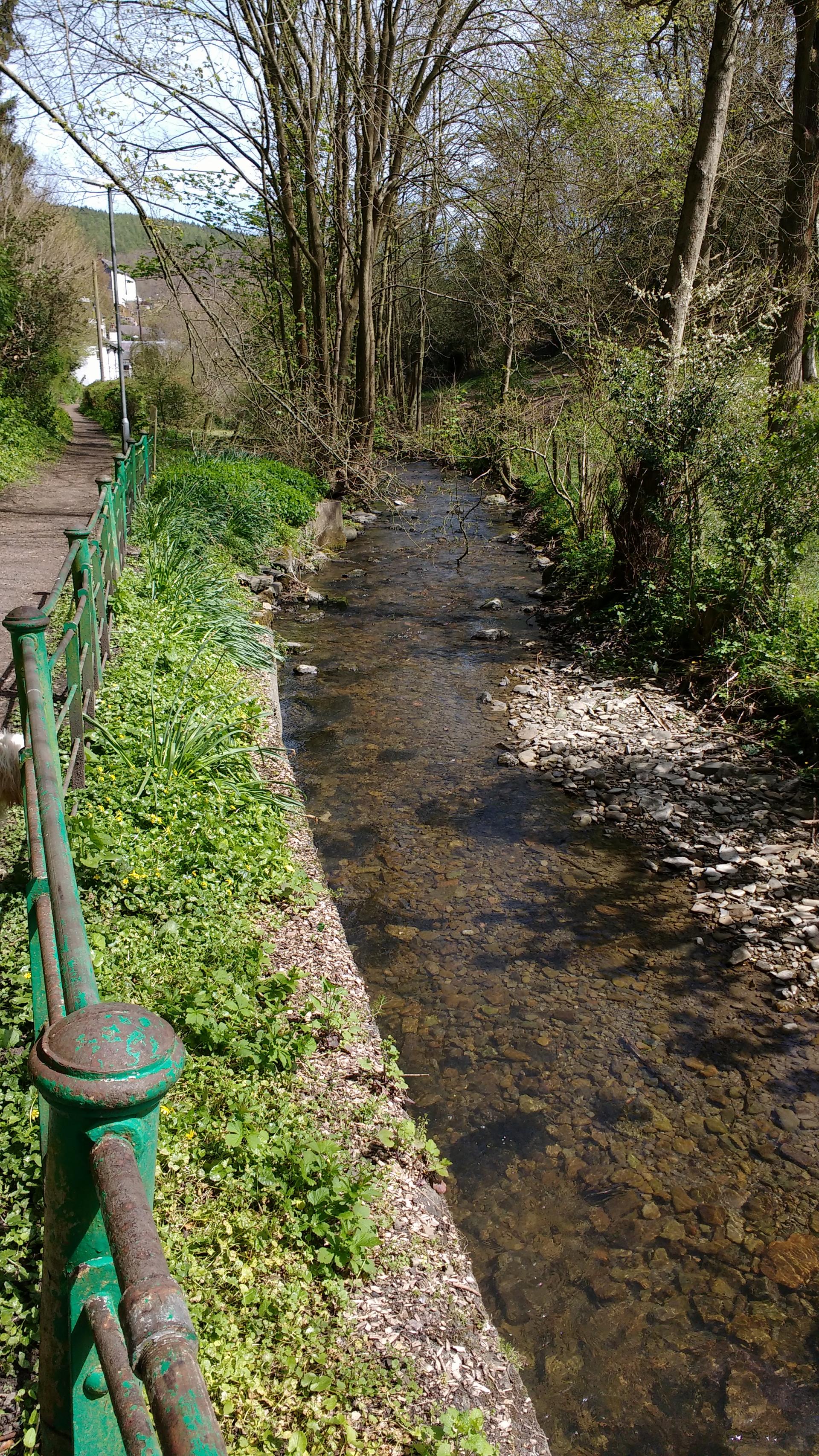
4 Wyl Cwm Brook
Winding our way back into Knighton, we are now following the route of the small Wyl Cwm Brook. This small babbling brook feeds into the larger River Teme, which runs through the centre of Knighton just a few hundred metres from here.
Along the river’s course several springs feed it with fresh water. A clean water supply is fundamental for any town. Without water, life and trade proves difficult to sustain. But what does the river have to do with Offa’s Dyke? This particular brook may have little influence but others along the dyke’s path may have been significant.
In around 800 AD, records described Offa building his dyke “from sea to sea”. The Severn Estuary to the south and the Dee Estuary to the north are 117 miles apart. Yet today Offa’s Dyke only totals 70 miles - a later National Trail joins up all the gaps. So what happened to the rest of the Dyke?
Some sections of the dyke were deliberately destroyed over the centuries, while others may have simply eroded away. Another possibility is that it was never actually a complete route from coast to coast. And that is where rivers come in to the story.
The dyke was an immense challenge to construct. In some areas large rivers could have served the same defensive function as the dyke. So the engineers and builders may have decided to take advantage of these natural features.
For example, along the 40 miles between Hereford and Monmouth the River Wye carves through the countryside. The Wye’s course forms a natural boundary that would have left a man-made one unnecessary. River courses, along with areas of dense forest or vast marshes that were hard to build through, may well explain the dyke’s missing sections.
By following in his footsteps, we have traced King Offa’s grand design for a dyke that divided nations, protected his kingdom and showed off his prowess. Offa’s Dyke stands as a monument of an era when wars marked the edges of the continent, mass migration was seen as a threat and Britain had a complex relationship with the rest of Europe.
So the context in which it was built may not be so different to that of today. Offa's Dyke then becomes a monument of the past and a symbol of the present.
Directions
Continue along this road until you reach the main high street again in Knighton. Our starting point at the Clock Tower should be just uphill to the left.
Your browser is out of date, and unsupported by this website. Please upgrade to the latest version to use this website.
A short walk along the ancient border between England and Wales
Winding from coast to coast across moorland and mountains, what looks like a simple ditch carries national importance. Offa's Dyke marks the ancient border between Wales and England.
While the dyke itself is obvious, we don’t know for certain why it is here. Or who built it or even when.
This trail retraces the steps of an ancient king to explore how Offa’s Dyke came to be. It also looks at the Dyke’s impact on two nations and how it is managed today as a living, breathing monument.
Follow the trail by clicking on the map pins or downloading the guide below
")
")
")
 Some sections of the dyke were deliberately destroyed over the centuries, while others may have simply eroded away. Another possibility is that it was never actually a complete route from coast to coast. And that is where rivers come in to the story.