If you ask someone what comes to mind when you say Devon, they might mention seaside holidays in places like Torquay, driving over the moors of Dartmoor, or perhaps sampling the county’s famous cream teas! Few will mention Teignmouth. This walk gives you the opportunity to find out more and discover Teignmouth is not just another Devon seaside resort.
We are going to look at Teignmouth from three particular angles. First we will explore the physical landscape including the steep valley sides and hidden streams, the estuary, spit and beach, finding out about the processes that formed them. Second we will discover how the town has been shaped around this physical landscape and how humans have intervened to change or control it including draining marshes, culverting rivers, building seawalls, reclaiming sand dunes and constructing flood defences. Third we will find out how Teignmouth’s location and the characteristics of the physical landscape shaped the economic landscape. We will discover an array of activities that have provided a livelihood for the people of Teignmouth including fish, salt, ball clay and timber. Along the way there are also stories of a Romantic poet experiencing bad weather and the French invading twice!
This walk is about being a landscape detective – looking for clues in the lie of the land, in buildings and architectural styles, in street layouts and street names, in pub names and shop fronts – that help us to understand the past and present of the town.
The walk is almost circular, starting at the Teign Heritage Centre opposite the railway station and finishing on the seafront. It is about 1½ miles long, mostly on the flat and along pavements and paths. There are a few steps which can be avoided if desired. I hope you enjoy the walk!
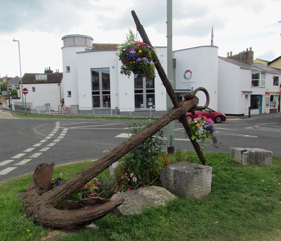
From the Teign Heritage Centre cross the road to the large decorated anchor and look towards the train station.
2 A hidden river
Welcome to Teignmouth! Looking across to the station you can see a built landscape of roads, buildings and a car park. What interests physical geographers like me is getting underneath the skin of the human-created landscape on the surface to understand the natural landscape hidden below. And the area where you are standing right now has quite a story to tell which we can discover from clues in the landscape.
Look across to the station building. To the left and right of it you can see that the land rises quite steeply yet the station and car park seem to be on quite a suddenly flat area.
Now look in the opposite direction at the street name just behind the anchor – Lower Brook Street. The shape of the land and the street name give us clues that where we are standing lies in a river valley although we can’t see any river.
Until about 200 years ago the River Tame flowed down this steep valley from beyond the station. When it came to this area of flat land the water slowed down and created the ‘Great Marsh’. From here it then flowed down the line of Lower Brook Street to meet the River Teign.
The Great Marsh separated the two early settlements of East and West Teignmouth. We will be visiting East Teignmouth first (to the right facing the station) – then going to West Teignmouth (to the left facing the station) and then learning how the Great Marsh was drained and the two villages were joined together.
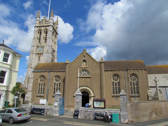
Cross back over the road towards the Heritage Centre then walk towards the church with a tower. Go through the church gate and walk past the right hand side of the church. Leave the churchyard by the next gate. Cross the road (Den Promenade) and go up the ramp onto the seawall. Stop by the information board and look back at the church.
3 A precarious position
The present church building dates to 1823 but there are records of a Saxon chapel here in 999AD. Around this chapel developed the small settlement of East Teignmouth. It was in a pretty precarious position on a narrow ridge that stood between the River Tame and the Great Marsh that we saw at the last stop and the sea.
The seawall that you are standing on is relatively recent. The sea used to come right up to the churchyard wall. There are accounts of great storms, one in 1744, even washing away graves.
Around the rudimentary chapel was a cluster of basic dwellings of the people of East Teignmouth. They would have been fishermen but they also made salt especially in the River Tame valley below St Michael’s Church but archaeological evidence has also been found on the beach of low walls thought to be connected to medieval salt extraction. The Domesday Survey carried out in 1086 mentions salt works here so this is the first historical evidence of economic activity in Teignmouth.
Retrace your steps down the ramp from the sea wall and go diagonally across the road into Regent Street. After 20 metres the roads splits with Dawlish Street on the right (where the traffic goes) and Regent Street ahead. Follow Regent Street for another 20 metres to where French Street bears off to the right. Stop at the junction by a grassy area surrounded by a wall.
4 England’s last invasion
At the last stop we heard about the early settlement of East Teignmouth with its fishermen and salt workers. In the grassy area here is the stump of the old market cross (although not in its original position) which dates from a 1253 charter so we have more evidence that trading was going on here from the thirteenth century.
Here again is a street name which gives another clue about history. The lane bearing off here is French Street and it commemorates the last foreign invasion of England.
St Michael’s Church that we saw at the last stop was positioned on an elevated ridge which made it visible from both land and sea. In 1690 the French navy had just beaten the English and Dutch at the Battle of Beachy Head. The French Fleet were moored at Torbay just down the coast from here and as they moved along the coast they spotted St Michael’s Church.
Boosted by their recent victory, about a thousand Frenchmen descended on East Teignmouth and neighbouring West Teignmouth and razed them to the ground. The locals managed to escape up to higher ground but their settlements and livelihoods were completely destroyed and the population was left homeless and destitute. A petition was sent to the Lord Lieutenant (the king’s representative) describing the incident:
“... on the 26th day of this instant July 1690 by Foure of the clocke in the morning, your poor petitioners were invaded (by the French) to the number of 1,000 or thereabouts, who in the space of three hours tyme, burnt down to the ground the dwelling houses of 240 persons of our parish and upwards, plundered and carried away all our goods, defaced our churches, burnt ten of our ships in the harbour, besides fishing boats, netts and other fishing craft...”
The Crown decreed that £11,000 be collected and given to aid the town. Churches from as far afield as Yorkshire contributed and the town and port was rebuilt and French Street dates from that time. Ironically, Teignmouth is now twinned with Perros Guirec in Brittany although they have imported onions and potatoes from there for over a hundred years. The pink granite walls, too, around the grassy area are gifts from France. There is a plaque on the opposite wall to commemorate the two events.
Continue along Regent Street for another 100 metres or so to a place where various roads merge at an open area known as the Triangle. Stop at the end of Station Road on the right hand side.
5 Reclaiming the land
Our walk from St Michael’s Church to French Street took us around the small settlement of East Teignmouth. Here at the Triangle we have returned to the site of the Great Marsh that we heard about earlier (our starting point is about 100 metres away at the top of Station Road).
The Great Marsh separated the two settlements of East and West Teignmouth but from the mid-eighteenth century there were moves to drain the marsh, reclaim the land and join the two villages. This can be seen on various old maps between 1765 and 1801 including ‘The Long Bridge’ in the 1700s. By an 1836 map the reclamation of the Marsh appears to be complete and this is the first instance of the settlement being labelled as a single Teignmouth without the East and West division.
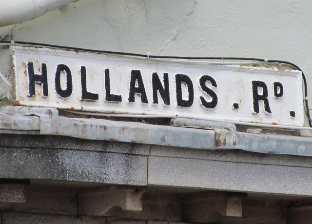
It’s not only on local maps that we can see evidence of the reclamation. Clues are all around you in the street names and buildings. Regent Street that you have just walked along, together with nearby Wellington Street and Waterloo Street, hark back to the early 1800s while Hollands Road takes its name from one of the prime movers of the reclamation work. A few steps beyond the end of Station Road is a WH Smiths. Look above the shop front to see that this was once the Royal Library. The curved bow windows of this building plus others just around the corner in Lower Brook Street are classic features of Regency style architecture of the early-nineteenth century.
From WH Smiths go right round the corner into Lower Brook Street. Follow it round to the right (under the arch) then turn left up Bickford Lane. Pass through Waitrose supermarket car park up to the A379 main road. Use the crossing to the right, then turn left onto a pathway by a stone wall. Stop by the wall where you have a view into the railway cutting below.
6 Steep slopes and level tracks
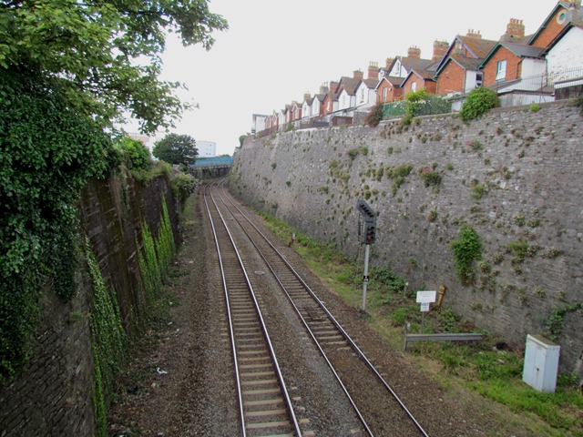
From here you can see just how deep this railway cutting is. If you look up to the backs of the houses on the far side of the cutting you realise just how steep the land is here.
The railway network was expanding rapidly in the mid-nineteenth century. The first serious proposals for an Exeter to Plymouth railway were mooted in 1835 and the engineer, Isambard Kingdom Brunel, surveyed a possible route in 1836. There were a number of difficulties posed by building a railway line between Exeter and Newton Abbot including the underlying geology, undulating landscape and coastal erosion.
At this point the railway line here is going from the seafront (to the right beyond the station) towards the estuary (to the left). In between, here behind the town centre of Teignmouth, are the steep hills and valleys of the hidden rivers Tame and Litterbourne. This deep cutting helps to keep the track on the level as it goes through this undulating landscape. Originally the cutting was inside a tunnel almost from the station to as far as you can see in the other direction but it was uncovered by 1883.
The railway connected Teignmouth on the main line between London and Plymouth and played an important role in the economic fortunes of the town which we will hear more of later.
Continue along the path with the railway on your right. At the end turn right up Fore Street. Stop on the railway bridge and look at the church up the road ahead.
7 A better position
At the beginning of the walk we explored the settlement of East Teignmouth and heard about its precarious position on a ridge between the River Tame, Great Marsh and the sea. In comparison the settlement of West Teignmouth was much better situated and here we’re right in the heart of the old West Teignmouth.
It was situated on a well-drained slope up above the Great Marsh and the estuary. Fore Street that you are on led down to a sheltered anchorage on the Teign shoreline. As well as easy access to the sea for fishing there was also access to the surrounding countryside.
This was also an important junction between the road leading north to Exeter (to the right of the church) and the road west to Newton Abbot (to the left of the church). So a variety of physical characteristics made West Teignmouth much better positioned than East Teignmouth and the village prospered.
Little is known about the village in the thirteenth and fourteenth centuries although like East Teignmouth it also had a thriving fish and salt trade. The red stone clock tower of St James Church that you can see is actually a thirteenth-century watch tower. Although it didn’t prevent a raid by French ‘pyrates’ in 1340 who ‘set fire to the town and burnt it up’. By 1801, before the draining of the Great Marsh and the joining of the two towns, West Teignmouth had three times the population of East Teignmouth (1,528 against 484).
Retrace your steps back to the main road. Cross over carefully opposite the fire station and turn right. Follow the pavement around to the right. At the gap in the railings opposite the Baptist Church cross over and then bear left onto the continuation of Fore Street. After about 50 metres Fore Street becomes Somerset Place. Stop where Bank Street goes off to the left and Teign Street to the right.
8 An expanding town
At the last stop we were in the heart of the old West Teignmouth on the slopes above the estuary. By 1805 the settlement of West Teignmouth had extended down the slope towards the port down narrow lanes such as Fore Street that we have just walked down.
Originally the River Tame, which left the Great Marsh and flowed along Lower Brook Street that we saw earlier, entered the estuary of the River Teign somewhere near here where Somerset Place is now.
By 1800 a local businessman called Robert Jordan had raised enough money to build a wall from where you are standing in Somerset Place towards the south. The wall protected the land behind from the tides and it could be turned from mud flats into land and used for extending the town.
The River Tame was channelled into a canal and later covered over to become the town’s main sewer. As with the draining of the Great Marsh that we heard about earlier, evidence of this land reclamation can be seen in old maps – it was almost finished by 1827 – and also in the street names. Here Brunswick Street, George Street and Waterloo Street all hark back to the early 1800s.
From the junction go along pedestrianised Teign Street. After about 50 metres is a modern building on the right called Pellew House and opposite is a narrow alley called Sun Lane. Go down Sun Lane. Stop round the corner by an old building with a stone lower half painted white and a wooden upper part painted black.
9 Fishy business
Sun Lane was one of several narrow lanes that ran from West Teignmouth down to the shoreline of the River Teign. In these lanes and alleys you really get a feel for what the town was like hundreds of years ago. A local poet, Mackworth Praed, wrote about West Teignmouth in 1836:-
The buildings in strange order lay As if the streets had lost their way Fantastic , puzzling, narrow, muddy Excess of toil from lack of study
As we have already heard, the people of East and West Teignmouth have caught fish here for at least 1,000 years, both in the river estuary and the inshore waters. Pilchards, herrings and sprats were all important fish to the local economy as well as the famous Teign mussels.
Fishing continues to be only a minor local industry today, as you will see as you go down onto the quays in a short while. About 20 trawlers are registered in Teignmouth today although they all sail out of nearby Brixham port which has ultra-modern fish handling facilities. There is still some small-scale dredging for scallops and in the estuary seine fishing for salmon as well as harvesting of mussels and oysters. Fishing currently accounts for just 0.3 per cent of Teignmouth’s economy!
This building used to be a Smoke House where fish were split open, cleaned and smoked dry over a fire. This preserved them in a more appetising way than salting, the other traditional method of preservation. Many locally caught fish were preserved by this method including herrings, haddock and salmon.
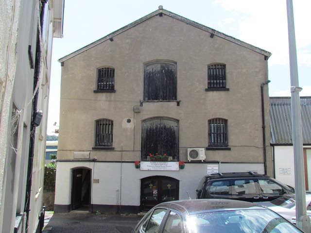
Retrace your steps along Sun Lane then turn left along Teign Street. Pass the front arch of the Thomas Luny House on the left and the Teign Brewery on the right. At the junction with Quay Road, cross over to the white building and white perimeter wall. With the wall on your right follow the road into a narrow lane leading to Willow Street. Follow the lane round to the left. Stop where the lane turns right outside the large building with barred windows which is now used as a funeral directors and bowling club.
10 Crossing the ocean
At the last stop we heard how smoking fish was an alternative to salting as a method for preserving fish in the days before fridges and freezers. This large building in front of you was originally a store for salted cod (although it has served many purposes including, as the barred windows suggest, a prison).
Some fishing was done in local waters but some fishermen ventured further afield. From the mid-sixteenth century boats left West Teignmouth in the spring for Newfoundland off the coast of Canada. They left loaded with cargo and even passengers and returned six months later with salted and dried cod which they sold directly for food or bartered for other cargo.
Fish became a staple food in Devon, particularly when meat was scarce during the winter months. Fortunes were made from the cod fishing trade although life was not easy, either on board the small 100-ton fishing boats or for the families left at home.
The novelist and diarist Fanny Burney visited Teignmouth in 1773. She noted the harsh lives of the wives of the Newfoundland fishermen during the summer when they were away. They “do all the laborious business such as the rowing and towing of boats” and “line fishing from the beach”.
During the French Wars between 1793 and 1815, conflicts between the French and Americans hampered the passage of fishing boats. Some106 Exeter-registered ships, many from Teignmouth, were captured by enemy warships or privateers. It is worth noting that the tall white building also at the bottom of Willow Street is called ‘Custom Keep’. This a reminder that Teignmouth only gained its independence as a Port in 1852; before that merchants had to travel to Exeter to pay their customs and dues to the city.
Go down the steps to the left of the Fish Store. At the bottom turn left into Old Quay Street then right into Quay Road passing warehouses on your right and a car park on your left. When you have walked almost the full length of the car park look for a road on the right called Gales Hill. Stop at this junction. To avoid the steps retrace your way back along the lane that led to Willow Street. Quay Road is straight ahead.
11 Rat Island
Where you are standing was once under water. The River Tame originally met the estuary of the River Teign somewhere just along Gales Hill. There was a sandy islet in the River Tame just here called Rat Island. The old red sandstone buildings over there at the corner of Gales Hill were fish stores and they were on that little island.
Now look the other way across the car park to the back of a white house with a row of three windows in the roof (we passed the front entrance on Teign Street earlier). This was the elegant house of Thomas Luny, a well-known marine landscape artist. His house originally backed onto the Teign shoreline and after he was paralysed he was able to watch the ships from his back windows. Now the view is of the port’s warehouses!
The fish stores formerly on Rat Island and the position of Luny’s house that used to be on the shoreline are two more examples of how the physical landscape has changed as humans have reclaimed land and expanded the town.
Turn along Gales Hill past the old fish stores and Ye Olde Jolly Sailor pub on the left. Note the new flood defence wall on the right by Fisherman’s Quay. At the end where the road turns left into Osmonds Lane is the New Quay Inn. Stop beside the poem painted on the wall.
12 Ode to the Teign
The New Quay Inn dates back to 1661. It was originally called the Newfoundland Fishery when Teignmouth port was engaged in the trans-Atlantic cod trade that we heard about earlier.
John Keats was one of many celebrities who visited Teignmouth as it became fashionable as a resort. He came in March 1818 to see his brother Tom who had TB and had come to the seaside to help his condition. Unfortunately it was a miserable time for them all as the weather was atrocious not unlike the summer of 2012 when I created this walk!
He wrote in letters to a friend ‘we are here still enveloped in clouds’ and ‘I would have taken a walk the first day but the rain would not let me; and the second...; and the third...’
However Keats wrote that he could see from his window ‘a pretty valley, pretty cliffs’ and perhaps that moved him to write an ‘Ode to the Teign’ which is reproduced here on the wall of the New Quay Inn. It starts “Here all summer I could stay...” so the weather must have got better for him!
Portrait of John Keats by William Hilton Wikimedia Commons
Directions
Walk across the beach in front of the New Quay Inn then turn right onto the New Quay. Stop at the end overlooking the estuary.
13 Stone, clay and wood
From the end of the New Quay you have great views of the Teign estuary. Look up the estuary and in the distance you will see the hills of Dartmoor. The underlying rock of much of Dartmoor is granite, which is a very hard kind of rock and therefore prized as a building material.
In the late 1700s a man called George Templer owned various granite quarries on Dartmoor. But the stone needed to be transported. He constructed a strange railway with tracks carved out of granite to the Stover Canal which linked to the Teign.
Then he built this quay (using his own granite) where the canal barges loaded the granite onto bigger boats. The stone exported from this very quay was used to build London Bridge (the one before the current one) and the British Museum!
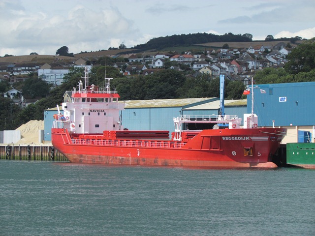
Another material passing through Teignmouth port was – and still is – ball clay, a material used in the construction of many ceramic items. Ball clay deposits are relatively scarce due to the combination of geological factors needed for their formation and preservation and they are only quarried in Britain at a few sites in Devon and Dorset.
One of those sites is Bovey Tracey, less than 10 miles from here on the edge of Dartmoor and ball clay has been exported from there through Teignmouth ever since the eighteenth century. The annual volume grew from 10,000 tonnes in 1785 to 200,000 tonnes today.
Did you know that Teignmouth is the only major working port on the south coast between Southampton and Plymouth? You can see many of the berths and storage buildings from this point. The port’s five new berths can handle ships up to 120 metres long with a 5 metre draught. About 35 to 40 ships a month pass through here. Aside from the 200,000 tonnes of ball clay handled by the port every year there is also 200,000 tonnes of other bulk products including animal feed, grain, stone chippings, salt and forest products. The port is completely computerised for stock control, delivery and tracing materials and works on the ‘Just In Time’ system especially for the ball clay.
Go round the other side of the New Quay to the Ship Inn. Turn right and go down the ramp onto the beach. The buildings on the left are the back of the houses accessed from Teign View Place. Stop outside these houses.
Note: At high tide you may not be able to walk along the beach here. Go up Queen Street at the side of the Ship Inn then turn right onto Northumberland Place. Turn right down Ivy Lane and stop at the shoreline.
14 Fighting the tide
The row of houses here are actually old fisherman’s storehouses right on the beach which have now been converted into holiday homes. This area is known as the Back Beach as opposed to the main beach which we shall see shortly. Even though this beach is not facing the open sea it is still affected by the tide and prone to flooding.
Some of the worst floods were in 1980 but I have seen significant damage too. Waves often reach half way up the ground floor windows, which I witnessed a couple of years ago, and water flows up the narrow streets from the beach inundating Somerset Place, Northumberland Place and Teign Street.
As you have walked along the shoreline from Gales Hill past Fisherman’s Quay and the New Quay you might have noticed various new flood defenses. These include flood gates at the entrances to Teignmouth Port and Osmonds Lane; flood walls and flood-resistant windows at the New Inn; and flood-resistant windows and doors and a raised concrete walkway along these beachside properties. The streets running down to the beach such as Queen Street have new flood gates and defensive walls too. These are all part of a new £4 million flood defence scheme for the waterfront and the works have been carried out in the first part of 2012. It is hoped that the new defences will minimise the flood risk for over 413 properties including these on the Back Beach.
If you think back to earlier in the walk you will remember that this area was once mud flats until it was drained and reclaimed. The tides and waves are trying to reclaim their territory but for now human engineering is winning the day.
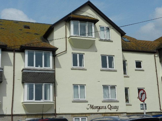
Continue along the beach. Stop on the raised walkway in front of the modern Morgans Quay development, noticing the large jetties at right angles to the walkway.
Note: If the tide is too high or you do not want to walk along the beach, go up Ivy Lane and turn right along the Strand. The other side of Morgans Quay is on the right.
15 Torpedo boats and luxury yachts
This modern block of flats is called Morgans Quay. Its name and the jetties at right angles to the walkway are the only clues as to what used to go on here. The Morgan Giles yard was one of three shipbuilding yards that were located here on the Back Beach.
The boom period for shipbuilding was the late 1800s. It began in 1849 with the arrival of a man called James Mansfield who was attracted by the proximity of the port to the new main railway line and the rail siding leading directly into the Old Port. He built wooden schooners and yachts for the surrounding gentry. By the late nineteenth century iron replaced wood and most of the shipyards closed although small boat building continued on the Shaldon side of the estuary.
Almost a century later, just after the First World War, Morgan Giles bought the derelict Strand Shipyard and followed Mansfield’s footsteps using highly skilled craftsmen and good sound management to build racing dinghies and motor launches. In the 1930s it specialised in building high-quality yachts for royalty including six for the River Nile! This encouraged large numbers of pleasure craft to come and visit the harbour.
During the Second World War, the Morgan Giles yards built motor torpedo boats and served as an American repair base with 150 employees. After the war it built luxury boats and yachts once more but in the 1960s the business ran into financial difficulties as people were reluctant to pay for such high-quality work. It was sold in 1969 but the subsequent owners all failed. As you have seen on our walk along the Back Beach there are still plenty of yachts and pleasure craft around but the yard was closed down and demolished to make way for the retirement flats you see today.
Continue along the walkway and beach to the ferry departure point at the end of Lifeboat Lane.
Note: If you are taking the alternative route away from the shore, continue along the Strand. At the end go straight on at No Through Road signs. At the RNLI Lifeboat Station follow the road around to the right and stop at the shore.
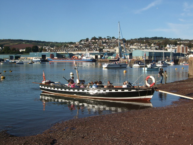
16 Crossing the estuary
The village on the other side of the estuary is Shaldon. Since the eleventh century the people of Teignmouth and Shaldon have moved across the estuary by ferry making this one of the oldest passenger ferries in England. Its black and white gunwhales reflect the look of Elizabethan galleons.
The ferry used to dock slightly further back down the quay at Ye Olde Jolly Sailor Inn on Gales Hill that we passed earlier (that pub used to be called the Ferry Boat Inn). Now it docks here at the end of Lifeboat Lane. If you have a bit of time I thoroughly recommend a trip across and back again. It will give you an alternative view of Teignmouth.
The bridge that you can see crossing the estuary in the distance was built in 1827 by the Shaldon Bridge Company. The original bridge was 1,671 feet long and made of wood with a swing section in the centre that allowed tall ships to pass.
There were toll houses on either end because it was part of the network of turnpike roads developing at that time. The bridge failed in 1838 and 1893 and was also rebuilt in 1931 then 1948 when the tolls were abolished. The last works were in 2002 when it was widened and strengthened.
This remains the only bridge across any of the major estuaries in south Devon and saves a significant trip round the top of the estuary at Newton Abbot.
From the shore, go along Lifeboat Lane. Go up the ramp to the right of the Lifeboat Station and carefully cross the car park to the railings overlooking the sea.
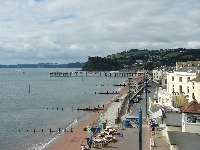
17 Sand and spit
Normally a river gets gradually wider as it approaches its mouth and empties into the sea. Not so here. At the last stop we could see right up the River Teign which was quite wide. But look across at the narrow opening that ships must pass through to get between the sea and Teignmouth port. Why is there such a narrow channel?
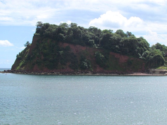
The answer lies across the water in the wooded cliffs on the opposite side of the estuary mouth. That is The Ness, a headland composed mainly of red sandstone.
As the sandstone rock is eroded by the sea the grains of sand are carried by the tides and waves across towards where we are standing, a process called long shore drift. Over tens of thousands of years this material built up to form a sand bank known as a spit. All the land that you can see from the sandy tip beyond the end of the car park and the other way towards the pier and beyond to St Michael’s Church is this massive sand bank. The sand continues to be eroded from the cliffs and so the channel needs to be dredged every day to keep it deep enough for ships to pass in and out of the port safely.
The sandy spit, known as The Den, serves several purposes. First it provides a sheltered position for shipping which is one major reason why Teignmouth developed into an important port. Second it created more land for the town to build on. This naturally-created land stands in contrast to the reclaimed land that we saw earlier.
Follow the railings with the sea on your right. Walk through the car park and onto the promenade with the sea on your right. Pass the small lighthouse and skate park. Stop near the first turreted kiosk.
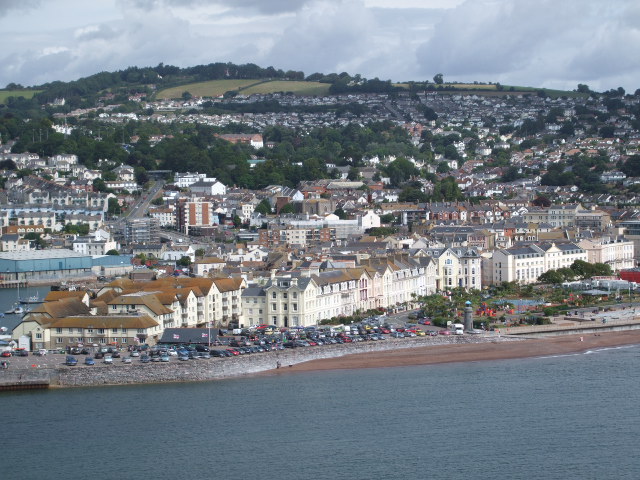
18 A fashionable resort
At the last stop we heard about the process of coastal erosion and deposition which created the enormous sand bank that you have been walking along. Many centuries ago it was an area of rough, sandy grassland used for grazing sheep and for drying or mending fishing nets. By the 1700s it had also developed into a social gathering place. The diarist Fanny Burney who we heard from earlier described donkey and pig races, cricket matches and wrestling on the Den during her visit in 1773.
By the early 1800s Teignmouth was emerging as a fashionable resort and it developed further during the Victorian period after the coming of the railway. The area of the Den was developed with pleasure gardens and a theatre; nearby was a public baths and ice rink. Early in the twentieth century tennis courts and a bowling green were added. Today the Den is used for fairs and concerts and it has play areas and a skate park where there used to be a paddling pool.
On the other side of the Den is the (much-altered) Grand Hotel where wealthy people stayed and the splendid Powderham Terrace built in 1869. Nearby are the Assembly Rooms where balls were once held. By the mid-nineteenth century Teignmouth was not only a well-established holiday destination but had attracted wealthy people to build large houses and villas on the slopes around the town.
With the opening of the branch line in the 1850s, nearby Torquay became a bigger and more popular holiday resort. Teignmouth still attracts tourists but not in the same numbers as the early nineteenth century. Today Powderham Terrace contains two of the few hotels left today in Teignmouth; most tourists stay in B&Bs or self-catering flats. Many other seafront properties are either apartments or care homes for the elderly such as the former Grand Hotel which is now sheltered flats.
Teignmouth Parade, 1896 Copyright The Francis Frith Collection ® www.francisfrith.com
Directions
Continue along the promenade towards the pier. Stop shortly after the pier near the Teignbridge notice board.
19 Bathing and flooding
At the last stop we heard about many of the leisure activities for tourists on the Den and the landward side of town. Here on the seaward side there was also plenty to do.
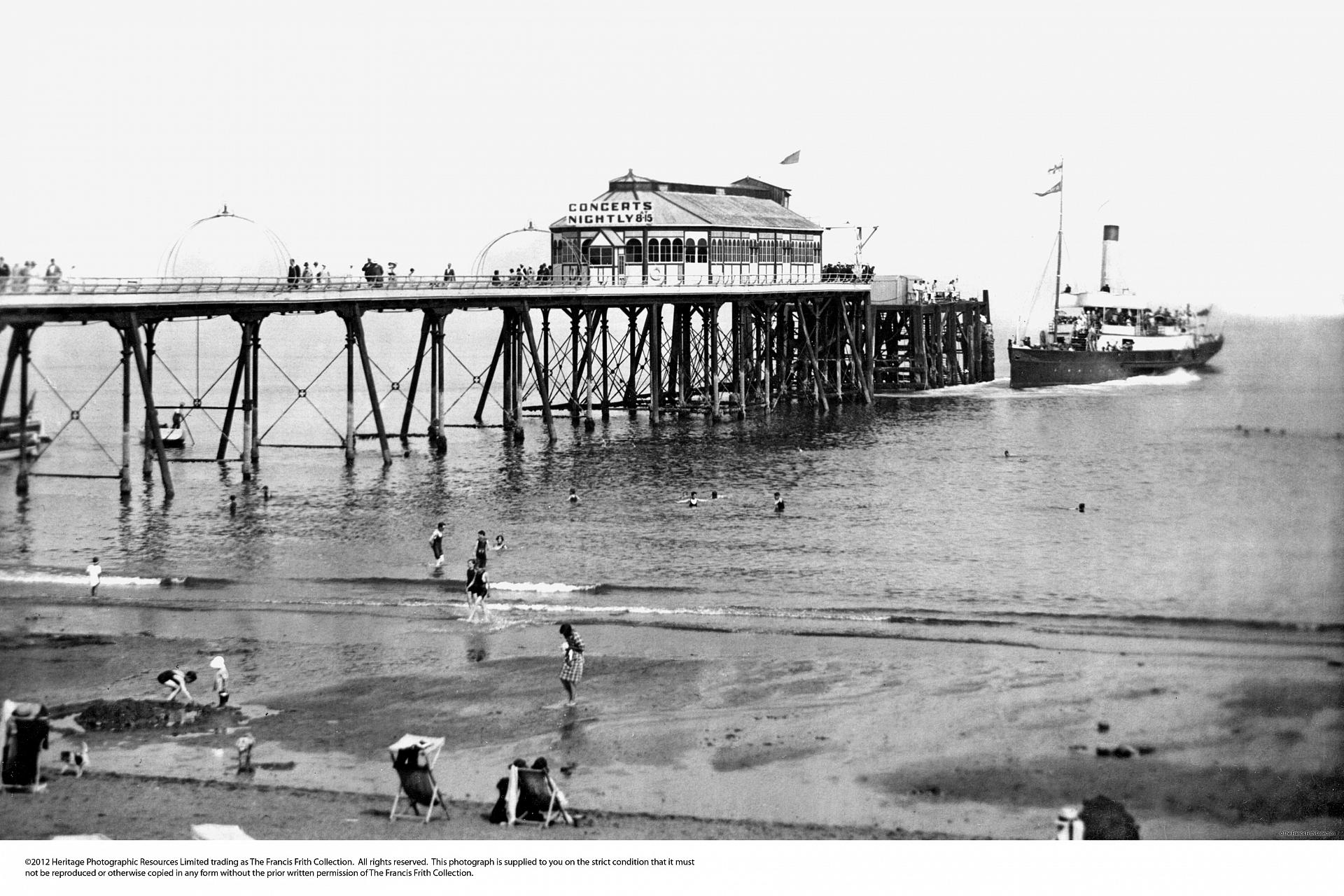
The Pier dates from 1865. It was built originally as a landing stage for passengers of coastal steamers but as tourism grew in the 1920s it became a pleasure pier with a ballroom and shops. The pier also served to separate the Ladies’ Bathing Beach below where you are standing now from the Gentlemen’s Bathing Beach on the other side.
The seawall that you are walking along was also built in the 1920s and space was created on the beach side for bathing huts, tents and kiosks. Of course the seawall not only creates a pleasant Promenade for tourists it also has an important function as a defensive structure. Since the 1960s there have been major floods in the town centre. Earlier we saw flood defences along the Back Beach but there have also been investments here along the main beach to prevent flooding.
Look along to the tower of St Michael’s Church – you can see just how low-lying the town is behind the sea wall. Since the 1980s considerable work has been carried out here along the Promenade. The concrete sea wall is concave – designed to throw back the waves. Groynes, the long wooden structures at right angles to the wall, prevent sand movement and break the force of the waves. There is also a flood gate near the next kiosk which can be closed as necessary.
Teignmouth Pier, 1925 Copyright The Francis Frith Collection ® www.francisfrith.com
Directions
Remain on the Promenade near the Pier.
20 Hidden stories
We hope you have enjoyed this walk around Teignmouth and playing ‘landscape detective’ to uncover some of the stories of this town. On this walk we have discovered more about the physical landscape which today lies underneath buildings, roads and car parks, learning about the processes that created landforms such as the Great Marsh and the spit.
We have also seen how humans through the ages have tried to tame and control the physical landscape including draining a marsh, culverting rivers, reclaiming mud flats, flattening sand dunes, building a seawall and installing flood defences.
We have also explored how Teignmouth’s physical location by the sea, on the edge of the moors, on the banks of a wide estuary and sheltered behind a spit have influenced the economic fortunes of Teignmouth from river and beachside salt pans to trans-Atlantic cod fishing; from ball clay quarries to granite extraction; from ship building to leisure boating; and from bathing machines to B&Bs.
Do take time to explore more. The Teign Heritage Centre where we started the walk is well worth a visit.
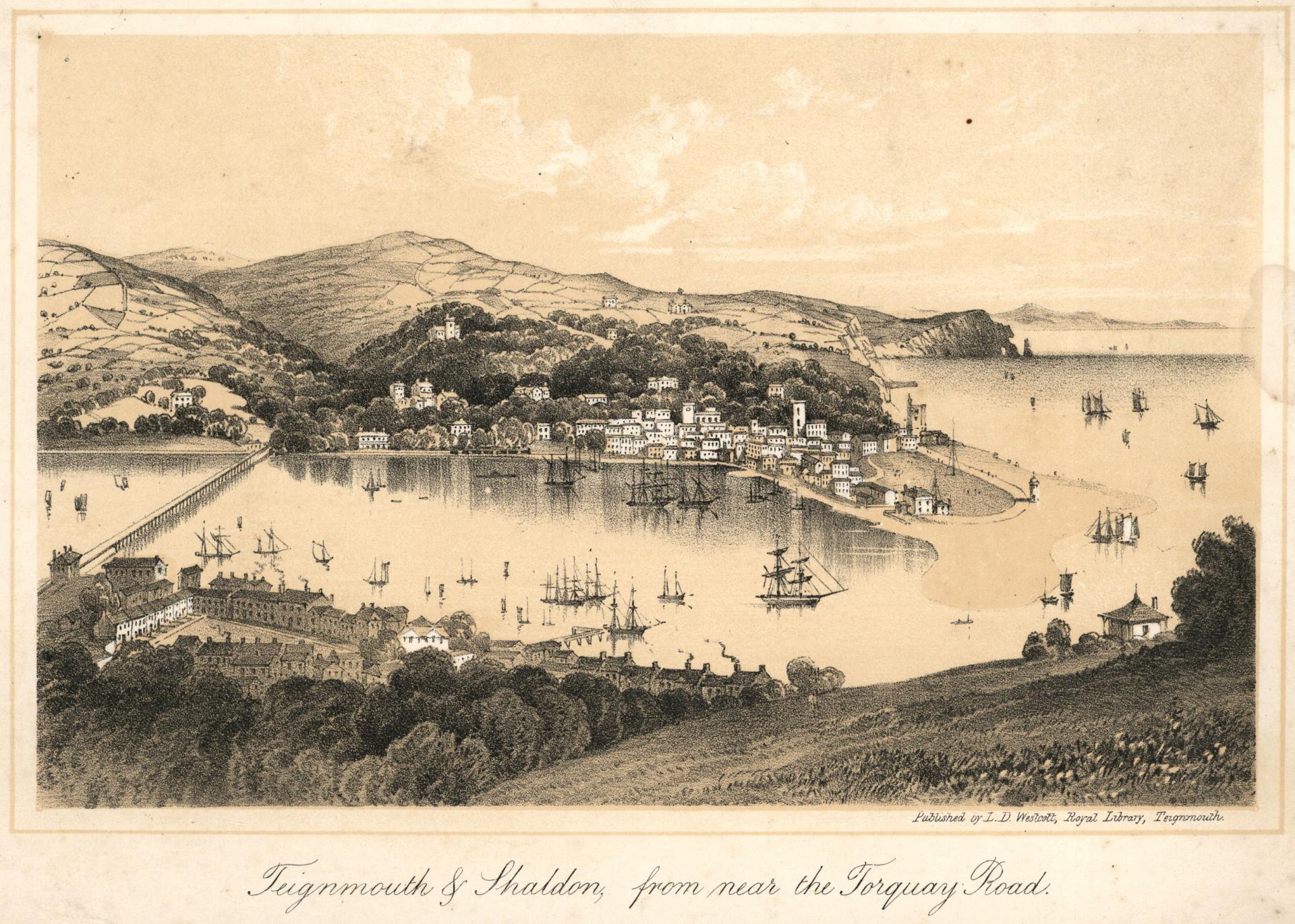
Teignmouth and Shaldon from Torquay Road c1850 By kind permission of Devon Libraries
Directions
You can enjoy the seafront or explore more of the town from here. To return to the railway station, continue along the Promenade as far as the next turreted kiosk. Turn left past the kiosk and over the steps/ramp to Den Promenade. Cross the road and parking area then go along the alleyway at the side of the fish and chip shop called The Street With No Name. At the junction with Regent Street go straight across into French Street. At the end of French Street is the Teign Heritage Centre where you started the walk and the station is across the road.
Your browser is out of date, and unsupported by this website. Please upgrade to the latest version to use this website.
East Teignmouth (c.1850), Devon Libraries via Westcountry Studies Library, Exeter
Teignmouth walk Devon
A walk around the seafront in Teignmouth, South Devon
What do you associate with Devon? Perhaps seaside holidays on 'the English Riviera', crossing the wilds of Dartmoor, or sampling the county’s famous cream teas!
Few people think of Teignmouth. But this walk shows you why the town is more than just another Devon resort.
Discover a dramatic physical landscape of steep valleys, hidden streams, crumbling cliffs and a spectacular estuary. Find out how the town was built on drained marshes and is protected from the sea.
This walk is about being a landscape detective. As you are walking, look for clues in the lie of the land, buildings and streets, pub names and shop fronts - they all reveal Teignmouth's past and present.
Follow the walk by clicking on the map pins or downloading the guides below