From the car park you can start to appreciate this lush and picturesque landscape surrounding the valley of the River Barle. Soon we’ll be strolling through woodland, along the tumbling river then walking up on the high moor to enjoy sweeping views across Exmoor National Park. But before we begin our walk, it’s time to start asking questions of this landscape, and look beyond the stunning scenery.
Exmoor is the kind of environment of which we should be asking questions, looking around and reflecting on what it means. Geographers tend to ask questions about landscape in three ways:
Firstly, as a made artefact, which reflects human endeavour and the relations between the human and non-human world, such as who or what made that hedgerow or why were beech trees planted as opposed to other species?
Secondly, geographers examine how landscapes are seen and represented. Landscapes themselves can be read as texts which reflect certain values and ways of seeing the world and reading the landscape can tell us much about the attitudes and the ideas of those that designed and curated it.
More recently, geographers have also been interested in how landscapes are felt and experienced, how they’re traversed, how they’re inhabited and what they do.
Now, let's begin our journey...
Directions
Go to the far end of the car park (to the left of the toilets) and join the tarmac path signed to Tarr Steps. Follow the path downhill to a stone bridge across the river.
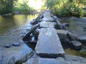
2 Tarr Steps
These stepping stones across the River Barle are known as Tarr Steps. Tarr Steps is a 'clapper bridge', made of wide flat stepping stones resting on stone-built piers.
This crossing is designated by English Heritage as a Grade 1 Listed building and as a Scheduled Ancient Monument. But no-one really knows how old the bridge is.
When the Royal Mail created a series of stamps commemorating British bridges, Tarr Steps was included alongside engineering marvels like the Humber Bridge and the Menai Straits Bridge. The Peace Bridge, built in Derry in 2011, was the final or most recent of the bridges, while Tarr Steps was presented as the oldest.
Yet viewed from a material perspective, Tarr Steps is the newest bridge in the stamp set. It has been damaged, swept away by floods and rebuilt at least 10 times, including as recently as February 2017. So we could also see this as a modern bridge.
The Royal Mail stamps confirm a certain idea of ‘ancientness’. But looked at in this context, what does an ‘ancient monument’ really mean?
Directions
Take the path along the river (with the river on your left) passing a coin tree. Stop when you reach a wooden bridge over the river on your left.
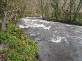
3 Bridge over the River Barle
One of Exmoor’s characteristic features is its very deep woodland valleys, like this one with the River Barle running through it. We think of these valleys as very dark and wild areas. Though this valley might look ‘natural’, these woodlands are all very carefully managed. And have been for thousands of years.
The phrase ‘ancient woodland’ evokes a kind of wilderness zone, but there is a long history of human impact on the landscape here, including ironworking and charcoal making, which took place over thousands of years.
In terms of wider woodland management, the importance of activities like coppicing and pollarding have become apparent in the last 30 or 40 years. After the great storm of 1987 when many woodlands lost trees, it was discovered that removing the dead trees was actually beneficial to the woodland. Patches of wood that had been completely choked with dark cover now had open areas where plants could grow again.
If we think about the woodlands’ importance as a global habitat, then the one thing the British Isles does very well is rot matter, because it’s so damp. The Serengeti plains of Kenya might have its lions, Svalbard its polar bears and China its pandas, but Britain’s equivalent are the beetles, fungus and moss which thrive in river valleys like this one.
Directions
Continue on same side of the river, following the footpath. Just after crossing a stream, ignore the first obvious path on your right, continuing alongside woodland, until you reach an obvious uphill footpath on your right. After passing an access road to Great Bradley Farm on your right, stop when you have a view down into the Barle Valley.
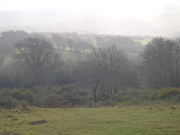
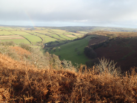
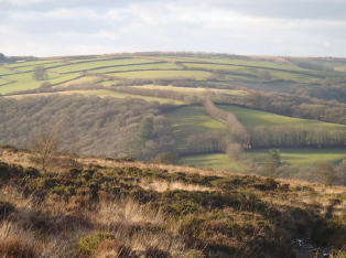
4 Barle Valley view, near Great Bradley Farm
Despite seeming ‘natural’, the view we are looking at here is a specifically curated landscape. The trees (beeches interspersed with exotic conifers) have been planted in order to achieve certain aesthetic effects. The landscape hasn't always looked like this...
Around 12,000 years ago, just after the end of the last glacial period, this was an empty land, best compared to tundra or like parts of Siberia today. But by the early Mesolithic period, between 10,000 and 8,000 years ago, there was a rapid rise in temperature, encouraging soil formation and pine and birch woodland. Rich grassland was an important element of the landscape for supporting a population of hunter gatherers. Then between 8,000 and 4,000 years ago, in the late Mesolithic period, it became deciduous woodland dominated by oak and hazel.
Moving forward to the Neolithic period, between 4,000 and 2,000 years ago, the uplands of Exmoor were felled and cleared to create pasture for grazing cattle and sheep. The woodland clearance begun in this period was over by the end of the Bronze Age (2,500 - 800 BC), but unlike Dartmoor and Bodmin Moor, there’s no evidence that this upland settlement was abandoned during the following Iron Age (800 BC -AD43). It appears to have been in continuous use right through to the Middle Ages (400 -1500 AD). Up on the high moors at Winsford Hill, we’ll see remnants of field systems dating back to this time.
By the end of the Middle Ages, a mini Ice Age led to a deteriorating climate. This along with a population collapse after the Black Death in 1348, meant these upland areas were practically abandoned. The impact of clearing all the oak and hazel woods had led to poor, infertile soil, increasing the waterlogged conditions on the top of the moors, which created bogs and the development of peat.
It was also during the Middle Ages, that the Royal Forest of Exmoor was created. Rather than denoting a wooded area, ‘forest’ meant a tract of land created by the Crown for royal hunting grounds. They were governed by forest law, which regulated the hunting of game animals, protecting the species and their habitats from zealous over hunting.
The limits of the Royal Forest were agreed via a walk known as a ‘perambulation’. During the first perambulation in 1219, the land's stakeholders, which included knights, foresters and villagers, decided the limits of the forest boundary. They marked it out through a combination of streams, boundary stones, prehistoric barrows, cairns and trees. In many ways, this was the first map of Exmoor.
In 1818 the Crown’s allotment of the Royal Forest of Exmoor was sold at auction. It was purchased by John Knight, an industrialist from Worcestershire. Knight paid £50,000 for the forest, more than twice that of the next highest bidder. So why did he pay so much for it? Perhaps he saw the area's economic potential, having visited farms in Norfolk and the Midlands where heathlands had been reclaimed to good effect.He probably also believed he’d derive some cultural capital from owning a ‘royal forest’.
During the nineteenth century, Knight and his successors set about ‘improving’ the landscape. They transformed Exmoor from ‘bleak wasteland’ to prosperous farmland through a huge programme of land reclamation. Miles of ditches were dug to drain water off the peat bogs. Grass was burnt off and lime was brought in huge quantities to improve the quality of the acidic soil and make the fields productive. Beech hedges were planted as windbreaks and for their aesthetic quality.
Directions
Follow the footpath as it bends right to reach a road, turn left onto the road and follow the road, passing Higher Bradley Farm with buildings either side, to reach a junction of paths. Take the second path on your right across the open moor, heading for the top of the hill. Follow the obvious path straight ahead. When you reach the road, turn right and walk across the top of the moor (alongside the road) until you reach stone marker by an area of bumpy land (just before the Winsford Hill car park).
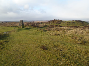
5 Wambarrows, Winsford Hill
Look across the landscape here. Can you spot three giant bumps in a row? They are about 25 metres across and two metres high. These lumps of earth are known as the Wambarrows.
Like Tarr Steps, the Wambarrows are a Scheduled Ancient Monument, and another signifier of ‘ancientness’ on Exmoor. They are in effect a Bronze Age cemetery; three large barrows, which were used as communal graves for the dead.
Here at Winsford Hill these barrows had another use. Silhouetted on the hill and visible for miles around, they were also boundary markers. The Wambarrows were first recorded during the forest perambulations of 1219. Today they are still used as boundary markers and ways to orient yourself on the otherwise featureless moor.
You might also be able to pick out rows of straight lines in the grass. These are the remains of a wall marking the edges of an ancient field system. These physical clues tell us that in the medieval period, the top of the moor here would have been farmed as arable land, before it was abandoned and left to naturally evolve into bog.
Directions
With your back to the Winsford Hill car park, follow a footpath across the moor, stopping above a huge cleft to look down into the Devil’s Punchbowl.
6 The Devil's Punchbowl
From here at the Devil’s Punchbowl we can see the coastline of South Wales and the Severn Estuary in the distance.
What really dominates the skyline though is Dunkery Beacon, which at 519 metres above sea level is the highest part of Exmoor.
On the sides of the actual beacon itself, look for some very clear signs of abandoned reclamation work; big square fields that were once farmed but have since been abandoned. In the nearer distance, the rich green fields with well-kept beech hedges are areas that have survived as reclaimed land and are still usable farmland.
It’s an impressive feat to turn this sort of marginal landscape into productive agricultural land, although probably an open question as to whether the equivalent of the tens or hundreds of millions of pounds which it cost, was worthwhile.
Recently, the Mires Project has been set up to reverse some of this nineteenth-century land reclamation and help return areas of Exmoor back to peat bog.
Cut through by the River Exe and tributaries including the Barle which we walked along earlier, Exmoor is susceptible to dangerous flooding. In August 1952, Lynmouth, on Exmoor’s north coast, was subject to the worst river flood to ever occur in the UK. Flash floods destroyed over 100 buildings and killed 34 people. As a response to this, the Mires Project aims to restore 2,000 hectares of peat bog, in effect creating a huge sponge on top of the moor to soak up excess rain water.
By blocking up the drainage ditches, dug in the nineteenth century, areas of Exmoor will revert back to bog and retain, not drain, water. As a result, over 6,000 Olympic-swimming sized swimming pools of water will be absorbed into the bog and prevented from entering the river.
Directions
Head in a south easterly direction across the moor to reach a road (Halse Lane) beside a house and a strip of woodland. Turn right down the lane then take the footpath off to the left across the moor to reach a sheltered structure.
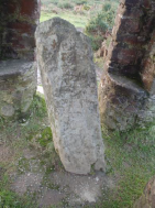
7 Caratacus Stone
We’re now at the Caratacus Stone, a stone inscribed with Celtic text. The stone itself was thought to be inscribed in the fifth or sixth century, however there is evidence that it might be a lot older. Some argue that it’s a standing stone, or menhir, dating back to the Bronze Age, but re-used and re-inscribed as an early Christian cross. There are many examples in the South West of England including Bennett’s Cross on Dartmoor, a Bronze Age menhir re-used in the early Christian period.
The Caratacus Stone is named after a first century chief of the Celtic Catuvellauni tribe who, like Boudica of the Iceni tribe, resisted the Roman invasion. The stone supposedly marks the burial place of a kinsman of Caratacus, but under archaeological investigation no burial was found. Again we have an ‘ancient’ site which has been engaged with, used and re-used a number of times.
The shelter that houses it is significant too. It was put here by Richard Acland, a local landowner who donated thousands of acres of land to the National Trust. The shelter was built to monumentalise an action of preservation, perhaps guiding us to reflect upon what a good man Acland was, rather than us wondering about the Celtic leader Caracatus himself.
Directions
Follow the footpath away from the Caracatus stone to reach the B3223. Follow the road until you reach a road junction. Turn right along the road then peel off left at the cattle grid to follow a well marked footpath across Varle Hill. Keep to the main path. Stop when you reach an obvious path junction across Ashway Side.
8 Ashway Side
In theory National Parks seem like areas that we all agree upon and that should be recognised. But there are complex historical and cultural processes that led to their designation.
In 1932, the mass trespass on Kinder Scout led to the Countryside and National Parks Act. This Act designated 10 areas in England and Wales as ‘national parks’: the Peak District, Snowdonia, Dartmoor, the Pembrokeshire Coast, the North York Moors, the Yorkshire Dales, Northumberland, the Brecon Beacons and Exmoor.
In reports that led up to their designation, the national parks were described as areas of ‘wild country’. For Exmoor, which was designated in 1954, it’s interesting to think about where the boundaries of this relatively wild country were drawn.
In some of the earlier reports in the 1930s and 1940s, the Quantock Hills were part of Exmoor. So were parts of the north Devon coast. Disagreements about where the boundaries of Exmoor should be drawn went hand in hand with objections from both Devon and Somerset County Councils, who both opposed the designation of Exmoor.
With its breathaking views and moorland landscape, Exmoor is a place that’s easy to take for granted. But it's worth remembering that it hasn't always been a National Park, with protected status, and this landscape has changed use, function and meaning over time.
Whether questioning how ‘ancient’ our monuments are or interrogating the way that our ‘heritage’ is memorialised, there's always more to Exmoor than meets the eye.
Directions
Take the main path right across Ashway Side to return to Tarr Steps. There is a pub here for a rest stop and a cream tea. Follow the signposted route back to the car park.
Your browser is out of date, and unsupported by this website. Please upgrade to the latest version to use this website.
Framing the view of Exmoor - Mark Robinson, Flickr CC
Exmoor walk
A circular walk in Exmoor National Park
As a National Park, Exmoor is somewhere we think of quintessentially ‘English’ and littered with ancient monuments. But it is in many ways a thoroughly modern landscape.
This walk explores the relationship between lthe ancient and modern, landscape and heritage, and considers just how ‘wild’ our wilderness really is.
Along the way, enjoy stunning views from Winsford Hill, dare to cross the devilish Tarr Steps and follow the rushing rivers of the River Barle.
Follow the walk by clicking on the map pins or downloading the guide below
 - Flickr CC.jpg)

%20Jenny%20Lunn.JPG "Fallen branches are home to insects, fungi, mosses and lichens © Jenny Lunn, Discovering Britain")

,%20Master%20of%20the%20Devon%20and%20Somerset%20Staghounds%20Wikimedia%20commons.jpg "Hunting scene in the 'Royal Forest of Exmoor' © Wikimedia Commons")


 With its breathaking views and moorland landscape, Exmoor is a place that’s easy to take for granted. But it's worth remembering that it hasn't always been a National Park, with protected status, and this landscape has changed use, function and meaning over time.