1 Welcome to Bodmin Moor

Bodmin Moor in Cornwall has been designated both an Area of Outstanding Natural Beauty and a UNESCO World Heritage site.

On this short walk we'll look at the physical landscape of the moor and see how it was formed and shaped by natural processes. We will find out about the underlying geology and learn how the flora and fauna here are affected by the local conditions.

We'll also discover more about the people who have made their home here over thousands of years, uncovering evidence of their settlements ritual sites, and finding out how these humans made a living from this inhospitable landscape through farming, quarrying and mining, and more recently, tourism and leisure.

Aerial view of Bodmin Moor

© Historic Environment Record, Cornwall Council 
Directions

Go to the top of the car park where there are two information boards. From here, take the steps on the left and go onto the grassy area. With your back to the steps, turn left across the grass until you reach a broad stony track that leads onto the moor. Turn right and continue along the track for about 500 metres. Stop when you reach two standing stones on the right of the track, each about two metres high.

2 Stories in the stone

In the short distance from the car park to these stones, you will have got a sense of the openness and barrenness of the surrounding landscape.

A moor is generally defined as a wild stretch of upland. It’s an open, treeless and infertile place where only hardy plants such as heather, coarse grass and bracken grow. We’ll find out more about the underlying geology as well as the typical flora and fauna later in the walk but at this stage let’s look around and begin to appreciate the characteristics of this landscape.

During his visit to the moor in 1850, novelist Wilkie Collins described a landscape very similar to the one we are standing in:

“Wherever we looked the horizon was bounded by the long dark undulating edges of the moor. The ground rose and fell in little hillocks and hollows, tufted with dry grass and furze and strewn throughout with fragments of granite. The majestic loneliness and stillness of the scene were almost oppressive to both eye and ear.”

Although this is an empty and sometimes bleak landscape, humans have been coming here for thousands of years, making their home here and using the natural resources of the area to forge a livelihood.

That is what this walk is all about – discovering how humans have adapted to a seemingly inhospitable landscape through time. We will see all sorts of interesting evidence of this.

And here is our first example. These two standing stones are known as The Pipers. Nobody knows for certain what their purpose was, but they seem to be linked to other nearby standing stones.
In fact, this area is rich in Bronze Age monuments like these which are normally linked to ritual, ceremonial and burial sites.

These two stones are an example of how Bronze Age humans took advantage of the abundant granite stone lying around them to construct monuments and buildings. We’ll find out why they’re
called The Pipers at the next stop.

If you have time, look around and see if you can spot another tall granite pillar near a scrubby tree. Unlike the rough stone of the Pipers, this one has been carefully shaped and inscribed ‘RIL 1846’. This is a boundary marker for the nearby medieval manor of Rillaton. It represents another example of human habitation in this area and we’ll hear more about it later.

 
The Pipers
© Mike Scott
Directions

Walk about 100 metres in the direction of the stone building and clump of trees. Continue until you are inside a circle of standing stones. Stop next to the waist high stone in the centre.

3 Into the unknown

We are now inside a circle of standing stones called The Hurlers. Like the stones that we saw at the last stop, these date back about 3,000 years to the Bronze Age. They too are granite, picked from the nearby landscape and deliberately placed in a formation.

There are actually three circles. Two of them are obvious - the one we are in now and another ahead of us. The third circle between where we are standing and the track from the car park is difficult to find as very few of the stones remain. You might notice that the three stone circles are all in alignment.

This mysterious prehistoric site, which is unique in Cornwall, should arouse your curiosity. What were these circles for? Who built them? Why were they built in this location? Why are there three circles? As Bronze Age people left no written records we can only guess at their purpose. What an intriguing puzzle they have left us! There are many other prehistoric structures nearby so this part of the moor must have been a very important ritual site for our Bronze Age ancestors.

You might be wondering why this monument is called The Hurlers. Hurling is a local game played in Cornish villages. A metal ball is thrown into the crowd and the winning team is the one that gets it either to a pre-arranged place or outside the parish boundary.

Daniel Defoe came across a game of hurling on his tour of England in the early 1700s and was unimpressed:

“I confess, I see nothing in it, but that it is a rude, violent play among the boors, or country people, brutish and furious, and a sort of an evidence that they were once a kind of barbarians.”

According to folklore, local people were playing it here one Sunday and were turned to stone for violating the Sabbath. The same fate applied to the pipers who were supplying the music for the
festivities, hence the name of the standing stones we saw at the last stop!

At this point it is worth looking around to notice that we are standing in a wide, shallow ‘saucer’. Caradon Hill surmounted by its communications mast rises up on one side of us. On the opposite
skyline is Stowes Hill, where you can make out the face of a quarry.

Between the two hills, the rough moorland rises gently and is marked with many mounds and hollows. The few trees you see are stunted and bent by the prevailing south west winds. Areas of bracken, gorse and clumps of moorgrass contrast with the closely cropped sward. This area of high moorland has been used over centuries for grazing hardy breeds of cattle, sheep and ponies.


The Hurlers
© Pat Wilson
Directions

Walk uphill from the large circle keeping the tall stone building and clump of trees to your right. Go through the next circle and follow a grassy path, heading for some distinctive bumpy mounds which cross your path about 20 metres from the second circle. Stop when you reach this line of mounds.

4 Humps and hollows

Look to your left and right and you can see a distinctive meandering line of small humps that cut across the path. You get a clearer view of their structure if you climb up onto one.

Follow the line of humps with your eye and you can see them winding across the moor. Can you see that beside most of the humps there’s a round hollow? This is not a natural landscape. It’s our
first example on this walk of how humans have exploited the natural resources of the moor – in this case the granite rock underneath our feet.

Though places as diverse as Bodmin Moor, Dartmoor, Lands End and the Isles of Scilly appear to be separate and have different characteristics, they are in fact all united underground as one continuous block of granite.

Granite is quite literally as old as the earth. Its origins go back about 300 million years to a time when molten material called ‘magma’ forced its way up from deep down at the Earth’s crust to the
surface. Magma cools very slowly as it moves upwards and is composed of three minerals; glassy quartz, black mica and a white/pink mineral called feldspar.

As the molten granite cooled, spaces within it allowed gases to intrude, condense and solidify into mineral ores. Mineral ores are rocks containing minerals like iron, gold or lead which can be extracted. Across the moor there are particularly rich veins or ‘lodes’ of tin and copper running through the granite.

In prehistoric times, these minerals could easily be found where natural streams exposed or washed out the mineral ores from the rocks. This process was known as ‘streaming’, a similar technique used by prospectors when panning for gold, and indicated where people should dig to find more.

Over the centuries these ore deposits became exhausted. By medieval times, prospectors had to look further afield to find the mineral veins or ‘lodes’ in the land beside the streams. To begin with,
the ore deposits would still be close to the surface, but as they worked uphill away from the stream they had to dig deeper. A pit was dug down to reach the mineral lode and the unwanted material (known as spoil) was thrown up to the side. The technology of the time restricted how deep they could go so another pit was dug further up. It is this method of mineral extraction that has created this feature of humps and hollows, known as ‘lode-back pits’. We will cross two more lines of these lode-back pits on the way to the next stop.


Lode back pits
© Mike Scott
Directions

With the stone house and trees on your right, continue up the slope following the grassy path. Pass to the right of an isolated boulder and through another line of lode-back pits. Continue ahead passing to the right of another isolated boulder lying on the ground. Pass through a third line of pits. As you reach the top of the slope, straight ahead, you will see a very large mound. This is Rillaton Barrow and it is marked as a ‘tumulus’ on the OS map.

5 Treasure trove

We have now walked up the slope and from here we get a good view of the lay of the land. The ground falls away quite steeply in front of us and the rough open moorland is replaced by lush farmland and woods in the valleys below.

Hidden amongst the woods was the medieval manor of Rillaton. You might remember at the start of the walk we saw a boundary marker for Rillaton, so you can appreciate how extensive their lands were. This mound shares the same name - Rillaton Barrow.

This is a particularly large example of a ‘barrow’ or ‘tumulus’ - a manmade burial mound. In fact it is the largest in Cornwall. Its size and position on the skyline above The Hurlers suggests that it was the burial place of a very significant person, perhaps a tribal chief. This mound would have been created by the same Bronze Age people who constructed the extensive complex of monuments spread across the moor including the Hurlers and Pipers which we saw earlier. In the past, treasure has been found at prehistoric burial sites like these. This one too has been excavated by treasure seekers.

Walk round to the right, to the side of the barrow that overlooks the farmland below and climb a little way down the mound. You will find a small (often muddy) hollow on the side of which is a stone lintel above a small opening. It was in here in 1837 that stone workers discovered a human skeleton together with a bronze dagger, some ornamental grave goods and a gold cup.

As was customary with discovered treasure, the Rillaton cup was presented to the king. It disappeared for the next hundred years until it came to light in the possession of King George V who had used it as a shaving mug! It is now safe in the British Museum.

Mike: “At the price of muddy knees, I have looked in through the small opening and, as my eyes got used to the dark I noticed a luminous moss on the back wall of the cavity. It’s known as ‘goblin gold’, and only grows in dark places like underground caves. Why not give it a try.”

Facing Stowe’s Hill, do take time to look at the wonderful view which stretches away from the aptly named Sharptor to the right and over to the distant hills of Dartmoor.


Rilaton Barrow
© Mike Scott
Directions

Stand with the small burial chamber on your left and ahead of you is Stowes Hill (showing the face of a large quarry and a pillar of boulders on the top). Set off up the slope toward this. In about 150 metres you will see a cluster of granite boulders around a saucer shaped shallow depression. Stop here to study the scattered stones.

6 Groovy stones

We have already discovered that granite is formed from solidified magma from deep inside the earth. Granite is very dense. In geological terms it is ‘massive’ meaning that it lacks internal structures – and this makes it very hard and tough.

The stone circles, hut circles and remains of farms and cottages that we see across the moor are evidence of its longevity. Nelson’s Column is shaped from granite, as are many of the iconic silver-grey lighthouses that dot our coastline.

But it’s toughness also means that granite is difficult to cut and shape. It is still possible though, as we have already seen with The Pipers and The Hurlers. Here we can see more evidence of the granite being worked. Scattered on the grass around you is evidence of boulders that have been deliberately split in two. See too if you can find boulders that have a series of grooves along the top edge. These have been made by stone cutters as they tried to split the boulder.

Working in pairs, one stone cutter would have held a ‘drill’ - a weighted metal bar - while the other hit it with a sledge hammer. By first making a series of indentations across the surface, the boulder would eventually split. It could then be worked on to form a door post, a gatepost or a block for building.

We will soon find out more about one of the people who worked as a stone cutter here on the moor.


Split granite rock
© Mike Scott
Directions

Walk back to the track and continue ahead for about another 150 metres to reach an area on the right enclosed by a barbed wire fence. Walk along the fence until you reach the corner where you can see the small hollow of a filled in mine shaft.

7 Going deeper

We only have to stand still to enjoy the peace and quiet of the moor, broken only by the sound of the breeze or skylarks. But it wasn’t always this quiet up here. Here’s author Wilkie Collins again describing a scene he came across on his walking tour of Cornwall in 1850:

“We had been walking hitherto amid almost invariable silence and solitude; but now, with each succeeding minute, strange, mingled, unintermitting noises began to grow louder and louder around us. We followed a sharp curve in the tram-way and immediately found ourselves saluted by an entirely new prospect and surrounded by an utterly bewildering noise.

All about us monstrous wheels were turning slowly; machinery was clanking and groaning in the hoarsest discord; invisible waters were pouring onward with a rushing sound; high above our heads, on skeleton platforms iron chains clattered fast and fiercely over iron pulleys and huge steam pumps puffed and gasped and slowly raised and depressed their heavy black beams of wood. Far beneath the embankment on which we stood, men, women and children were breaking and washing ore in a perfect marsh of copper-coloured mud and copper-coloured water. We had penetrated to the very centre of the noise, the bustle and the population on the surface of a great mine.”

This barbed-wire fence protects us from falling into the mineshaft of one such ‘great mine’. Under our feet was ‘Stowe’s Great Lode’ containing tin, copper and iron ore.

By the middle of the nineteenth century a line of mines and pits stretched right across this hillside stretching for over two kilometres. It was so productive that the mine was worked continually from the sixteenth century for four hundred years.

To begin with the miners were able to access lodes close to the surface but eventually prospectors needed to go deeper. Going deeper underground presented several problems such as how to deal with flood water, how to get miners down deep shafts, how to bring the ore to the surface, and how to provide enough ventilation and light.

Can you imagine the din of the great beam engines powering the machinery, the head gear raising and lowering men and minerals, and the thumping of the ore-crushing stamps which hammered the minerals from the rock? Shafts led deep underground into utter darkness. Steaming funnels breathed out copperous vapours. Heaps of spoil waste littered the surrounding area. This would have been a noisy, dirty, dusty and dangerous place. Though there were profits to be made, most were enjoyed by the mine owners. The miners themselves faced dangerous work and great hardship.


Stowe's Great Lode entrance
© Mike Scott
Directions

Continue towards the quarry ahead. In about 100 metres you will meet an obvious track stretching from left to right following an embankment. Turn left to follow this track, keeping the embankment on your right. After about 200 metres the embankment peters out and where you see a low stone wall set in the cutting, you will find a crossroads of paths.

Turn right up a wide, straight track towards four grassy humps scattered with boulders. These are dumps of waste from the quarry. Turn right immediately before the first dump and follow it round for about 20 metres, keeping it on your left. Tucked in a recess between dumps, you will find a small cave-like structure.

8 An extraordinary story

When Wilkie Collins explored this corner of the moor in 1850, he was particularly keen to see the site of Daniel Gumb’s cave. As a novelist, he was probably attracted to local myths and legends. But Daniel Gumb was a real historical figure.

Daniel Gumb was born in 1703 to a humble family in a nearby village. It seems he had a natural genius for mathematics and a love of astronomy but he had to earn a living. He came to this area as a stone cutter working the moorstone. His mathematical skills enabled him to help with local surveys.

To avoid paying taxes, he found a huge slab of rock and cut out a cave about 9 by 4 metres under it - big enough to house his family.

He cut geometric drawings into slabs of rock, one of which you can still see on the ‘roof’ of his house. There is also a stone to the right of the entrance with the date 1735 carved into it, presumably the date he moved in. He married three times, had thirteen children and died aged 70. How tough he and his family must have been!

From this account of its size and the number of people who dwelt there, you can probably tell that what you are looking at is not his original cave. The original cave was somewhere nearby but it was lost or destroyed when the quarry was extended during the nineteenth century.

However, the local stone workers and antiquarians were so upset by its destruction that they built this ‘cave’ here as a memorial to this extraordinary man.

An interesting addition to Daniel Gumb’s story is that he was visited by William Cookworthy, a Devon chemist with an interest in porcelain. At that time, the china clay needed to make porcelain was imported, but Cookworthy thought it could be found in the granite areas of Southwest England.

Cookworthy came here to Bodmin Moor to ask Daniel Gumb for advice. Eventually deposits were found on Bodmin Moor and, in vast quantities, further west near St Austell.

The extraction of china clay from granite became – and still is – a major contributor to the Cornish economy. Cookworthy owes his fame to being the discoverer of china clay in Cornwall and for founding a porcelain factory in Plymouth (which eventually led to the development of the pottery industry in the Midlands). But ‘caveman’ Daniel Gumb played a significant part in the story.


Markings on Daniel Gumb's cave
© Mike Scott
Directions

Walk up above Daniel Gumb’s cave and you will find a path beside a wire fence near the quarry edge. Follow this path towards the prominent pile of rocks above you. Stop at this pile of rocks, which is called the Cheesewring.

NOTE: The approach to the Cheesewring involves following an indistinct path up between boulders. The descent to the quarry on the other side of the hill also involves a steep path. If you prefer not to go up to the Cheesewring itself, please use the following directions for an alternative and easier route into the quarry. This will mean missing Stops 9 and 10.

Alternative route to Stop 11 (Cheesewring Quarry)

From Daniel Gumb’s cave, retrace your steps back to the cutting and embankment. Turn left and with the embankment now on your left, follow the track until it takes a sharp bend to the right (200 metres). To your left is a granite pillar with three iron hoops set in the side. Step over the low bank ahead of you and walk down the grassy slope onto a broad track running across the hillside. Turn left along the track and enter the Cheesewring quarry via the dramatic cleft through the rock.

9 Tor Story

This strange pile of rocks has been visible on the skyline since we left Rillaton Barrow and now we can see it at close quarters. It’s known as the Cheesewring. Wilkie Collins gave a good description of it in his ‘Rambles Beyond Railways’:

“All the heaviest and largest of the seven thick slabs of which it is composed are at the top; all the lateral support of any kind. The fifth and six rocks are of immense size and thickness, and overhang fearfully all round the four lower rocks which support them. All are perfectly irregular; the projections of one do not fit into the interstices of another; they are heaped up loosely in their extraordinary top-heavy form on slanting ground, half way down a steep hill.”

Local folklore might insist that the Cheesewring was the result of a giants’ rock-throwing contest, but there is a geological explanation for this very strange formation.

Earlier we discovered how the hard granite of the moor was formed. Over tens of thousands of years, the surrounding softer sedimentary rocks were gradually worn away by the process of weathering and erosion. This left the hard granite exposed on the surface. Over the next 40 million years the climate changed from warm sub-tropical to almost glacial. The landscape around us reveals the dramatic effects of this glaciation.

Though tough, granite rock is very jointed and is susceptible to being weathered by freezing and thawing. Over time this process enlarged the joints and gives the tors their blocky appearance.

The tors are like pimples on the surface of the moor. They are simply the tougher areas of rock that are more resistant to weathering and erosion. So they remain as upstanding rocky masses, often silhouetted against the skyline like this.

The Cheesewring has attracted visitors for centuries due to its unusual shape. When the quarrying got close to it, there were fears that the work could cause it to fall. The small pile of rocks to one side was added sometime in the 1860s to support it. For its protection, the land owner, the Duchy of Cornwall, set legal limits to the extent of the quarrying - an early example of landscape conservation!

You’re probably wondering how the Cheesewring got its strange name. It has nothing to do with cheese. In the process of cider-making, apples are crushed and then pressed to squeeze out the juice. Layers of crushed apple (known as the ‘cheese’) are alternated in the press with layers of straw. As the press is lowered, the ‘cheese’ is pressed and apple juice flows into a trough ready to be made into cider. In the past, this pile of rocks must have reminded the locals of a cider press.

Poet John Betjemen wrote that the stones looked like “gigantic nodding mushrooms which will soon collapse”. How would you describe them?


The Cheesewring
© Mike Scott
Directions

With the Cheesewring on your right, pick your way up the slope towards the top of the hill. Stop when you reach the top where you’ll see other ‘mini cheesewrings’ around you.

10 Safe haven and summer pasture

From this vantage point we look out across east Cornwall and west Devon. To the right of Caradon Hill (with its communications mast) is Plymouth and Plymouth Sound. Further to the right is St Austell Bay with the lumpy hills where the china clay that we heard about earlier is found in abundance. To the left of Caradon in the distance are the hills of Dartmoor and going further to the left is the eastern area of Bodmin Moor.

But we’ve stopped here to look at more than just the view. Look around you and you can see that you are standing inside a wall of loosely-piled rocks. This is known as Stowe’s Pound and these are the remains of a neolithic hilltop enclosure. It’s not easily visible from here, but the lower ridge of the hill is also surrounded by a similar wall of loose rock. Archaeologists suggest that these remarkable structures date from the Neolithic Age about 5,000 years ago and were probably tribal centres or meeting places used for ceremonies, social events and trade.

This higher enclosure we’re standing in now was probably a safe area where the tribespeople and their livestock could retreat in times of trouble, whereas the lower, larger enclosure was probably a ‘living’ area. The Neolithic inhabitants were farmers using these high grasslands on the moor as summer pasture and returning to the more sheltered valleys as the weather became colder – very much as hill farmers do today.

From here you can also see another way in which the moor has been used by humans. Some of the hills are clothed in dark forests. These conifer plantations were deliberately planted for timber which provided another income from otherwise fairly poor agricultural land.


Aerial view of Stowe's Pound
© Historic Environment Record, Cornwall Council 
Directions

If the weather is clear do take time to enjoy the 360-degree view from here. When you are ready, make your way back down the hill to the wire fence near the quarry edge. Turn left away from the Cheesewring and follow the fence downhill. It is here where the path becomes uneven and steep, please take care. Pick a safe path downhill which will lead you round into the quarry. Stop when you are in the bottom of the quarry.

11 Between a rock and a hard place

As we have seen, there is a plentiful supply of easily-available stone lying on the surface of the moor. This has been used by humans since prehistoric times to create ritual monuments, buildings, walls and so on.

But demand for Cornwall’s hard granite grew from further afield and this led to a more widespread exploitation of the rock. We can see the evidence here in this vast abandoned quarry.

During the eighteenth century the Duchy of Cornwall, the owner of this land, granted permission for stone to be quarried. In 1839 a company was granted a lease to quarry here into the side of Stowe’s Hill. The company flourished. It received even more recognition when they displayed a nine-metre high granite column at the Great Exhibition of 1851 in London. During the second half of the nineteenth century Cheesewring granite was much in demand; it was used in the construction of Westminster Bridge, Tower Bridge, the Albert Memorial and even as far away as the docks in Calcutta, India.

Over time, the introduction of more readily-accessible granite from quarries elsewhere made the Cheesewring Quarry unprofitable. Some stone was removed during the first part of the twentieth century but by 1934 the quarry was closed.

The quarry now stands quiet and deserted except for the raucous caws of ravens. Rather than quarriers, today it attracts walkers, geologists, archaeologists and it provides an ideal venue for rock climbers to practise their skills.

Do take time to take a closer look at the granite itself. You can see that it is speckled and is made up of three types. The large white crystals are feldspar; it is this mineral that disintegrates into china clay. The small black shiny specks are mica and the grey coloured flecks are quartz. As we have already heard, granite is a very hard rock so ideal for building, but when smoothed and polished the colourful crystals make it very attractive stone. As a result it is used for decorative purposes including kitchen worktops and gravestones.

 
Cheesewring Quarry
© Mike Scott
Directions

Go through the quarry and out the other side. Continue walking for about 300 metres until you reach a line of large granite blocks on the right of the track. Turn left downhill towards a granite gatepost with a rounded top (20 metres). Turn left and walk along the track for a short while to look up at the row of stoneworks and hillocks which mark the site of quarrymen’s cottages.

12 A hard and lonely life

For the men who worked up here on the moor, it was often quite a long journey from their homes to reach the quarry. As the Cheesewring quarry became more successful, the owner built seven slateroofed cottages to house some of the workmen and their families.

Here you can see the stone remains and hollows of some of these cottages, which were constructed in 1864. Each house was built with a back garden and a shed. Water was brought to a storage tank, there was also a septic tank and a well. The long area enclosed by grassy banks which runs down the hillside in front of you was where the cottagers each had a strip of land to cultivate.

Even though it must have made life easier to live near their place of work, conditions were not so good. One worker wrote: “It was very hard living up Cheesewring. We used to pay an awful lot of rent, 1/9d a week! And the water used to freeze in the bucket in the kitchen. No radiators, no ’lectricity, just cold.”

These cottages were lived in until the Second World War. Shortly after, in about 1948, anything of use was stripped out and they were left derelict. They were finally pulled down in the 1960s. The Cornwall Archaeological Unit conducted a detailed survey in the late 1980s and deplored the destruction of these cottages, noting that “Had the cottages [been] left as unroofed ruins, this nineteenth-century site would have by now been one of the jewels of the archaeology of the area.”


Quarry cottages
© Mike Scott
Directions

Walk back to the granite post. From this point, continue downhill for about 100 metres, keeping the ‘garden wall’ on your left. At the end of the wall you meet a wide track running left to right. Stop at this junction.

13 On the right track

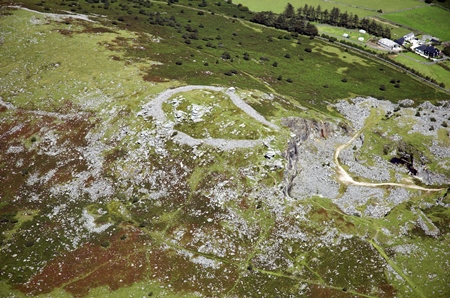
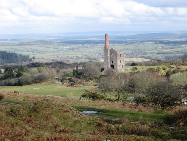
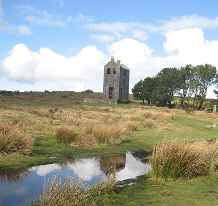
On this walk so far we have seen much evidence of mining ores and quarrying rock. As demand for both copper ore and granite grew, the mine and quarry companies faced increasing problems of transportation. The muddy lanes of the area were quite unsuitable for transporting heavy and bulky loads of ore and rock. Horse drawn carts were liable to get stuck in the mud. The potential productivity of the rich mines on the side of Caradon Hill forced local quarry owners to look for a solution. 

In 1827 a canal had been constructed linking nearby Liskeard with the coastal town of Looe. It was proposed that a railway should be built from Caradon to meet the canal at Liskeard, thus connecting the mines with the sea. The line of the railway was cleverly surveyed, allowing trucks to ‘freewheel’ down to the canal and then be pulled back up by horses. This was called The Liskeard and Caradon Railway.

Once the railway was in place, extensions to the mines and the quarries could begin. Mineral ore, granite and farm produce was taken down and coal, iron, machinery and timber was brought up. It became a very profitable business.

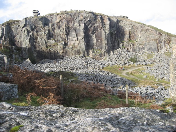
Steam locomotives were introduced onto this railway network in about 1860, making it easier to transport the great boilers, beams and machinery needed for the mines. The owners of the Cheesewring Granite Company followed suit and laid down a network of railway lines in this area around Minions to serve the various mines and quarries. Without these trackways neither the mines nor the quarries would have been so successful.

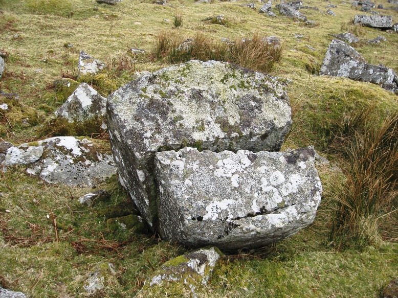
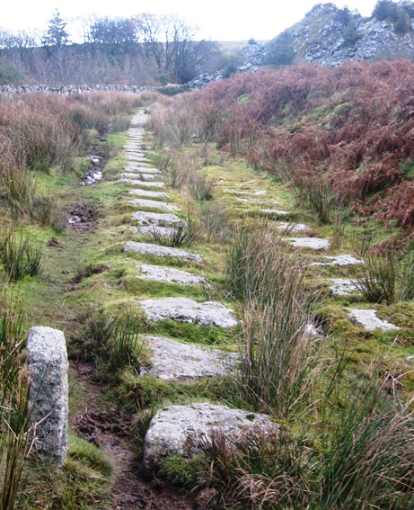
This wide path we’re walking on now was once part of this railway network. Take a closer look at the rows of granite blocks, known as ‘setts’, with pairs of holes drilled in them. You might need to look closely to see the holes as they are overgrown with lichen. These setts carried the rails in the same way as the more modern sleepers do.

There are other bits of evidence of the railway to spot if you are observant; for example, small pillars marked with numbers at intervals beside the track. These indicate the distance from Minions and were used for calculating the tolls to be charged for using the railway.

As we have already heard, the demand for copper and granite from this area rapidly declined at the end of the nineteenth century due to cheaper and more readily-accessible minerals found elsewhere. Mines began to close. By the beginning of the twentieth century the railways were largely redundant and by 1917 rails were being lifted.

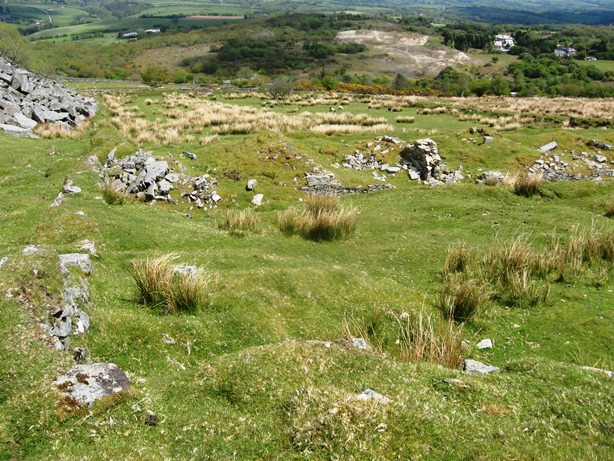
It now takes some stretch of the imagination to picture this whole area being criss-crossed with railway lines, sidings, loading quays and railway sheds. But this is just one more part of the story of this fascinating area that was once such a hive of industrial activity. It is now one of the most remote and peaceful places in the country.


Railway setts
© Mike Scott
Directions

Turn towards the Caradon mast and follow the railway track for just over half a mile, enjoying the luxuriant views (if the weather is clear). Stop when you reach an obvious fork, with the railway track continuing ahead and a track going to the left down beside a stone wall. On the right of the track is a small stone marked with the number two indicating it is the second toll marker from Minions.

Follow the lower path beside the wall down to South Phoenix Farm and onto a road. About 100 metres down from the farm is a public footpath that leads to South Phoenix Mine engine house. 


14 South Phoenix Mine

All across the moor you will probably have noticed many derelict stone buildings with chimneys attached. In fact they are a common sight across the whole of Cornwall. They are engine houses, built to house the machinery which worked the huge steam pumps that kept the mines free of water. Here is a particularly special one – the engine house of the South Phoenix Mine.

Although there was still copper and tin to be found on the moor, by the end of the nineteenth century it had become uneconomical to mine it. Gradually all the mines in this area closed. This mine, Phoenix United, closed in 1898. Then in 1907 a mining company took up the leases of a group of the nearby mines and optimistically reopened them. Work progressed rapidly. By 1909 men had restored the shafts and this new engine house was built and a boiler was installed. The Prince of Wales arrived for the opening ceremony and the shaft was named after him. Sadly, the min closed forever in 1917.

This came as a blow not only to the local people but throughout Cornwall. It was felt that if a Minions mine could’nt survive, there was little hope for any others in the county. So what we are looking at are the last remnants of a once large, proud and important industry.

Behind the engine house on the far side of the green area, a finger post indicates a path leading downhill into a small scrubby wood. Following this brings you past the mine captain’s house, now called Phoenix House, and out onto the extensive dressing floors where the ore was crushed and processed. You can also see the remains of the reservoirs that held the water necessary for the steam boilers and washing out the ores.

Keeping Phoenix House on the left, a path curves round leading onto the waste tips. Anyone interested in geology or who likes finding attractive fragments of rock will enjoy wandering across this ‘moonscape’. A happier result of the mine closure has been that nature has begun to reclaim these waste tips. Look to the left of the engine house and you can see patches of light- coloured ground, looking like a spoil tip. The mineral-rich material supports many species of moss including the only known site in the world of the extremely rare Cornish path moss! Because of this, the Phoenix Mines are designated as a Site of Special Scientific Interest (SSSI) 


South Phoenix Mine
© Cornwall Council with thanks to Cornish Mining World Heritage Site
Directions

Retrace your steps back to the road by South Phoenix Farm. Follow the road for about 700 metres up towards Minions. You will find a car park before you reach the village. Turn through this towards the group of dark trees and you will see an engine house. This is stop 15. 

15 Mining our heritage

We’ve now reached the stone-built engine house that has been a constant visual reference point during the walk. It once formed part of the Phoenix United group of mines but has recently been refurbished as an information and interpretation centre for the many and varied activities that have taken place over the millennia on Minions Moor.

Inside you can find out more about many of the things that we have explored on this walk including the formation of granite, more about rocks and minerals, the layout of the mines, the daily life of the miners and the flora and fauna of the moor.

Nowadays instead of mines and quarries the main local industry is tourism. Today visitors are drawn to the moor for the drama of its landscape, the richness of its prehistoric
monuments and to learn about its industrial heritage.

Minions village has two car parks which gives an idea of how popular it is, especially in the summer months. But throughout the year families, walkers, mountain bikers and horseriders all enjoy this wonderful upland environment. To cater for visitors, the village offers a small shop, two tearooms and a pub that claims to be the highest in Cornwall as it stands at 300 metres above sea level. And it is to the village that we now head for the end of our walk.


Housemans Shaft Visitor Centre
© Mike Scott
Directions

From beside the engine house, a path then a lane lead 300 metres past the cottages and into Minions village.

16 A 'new' village

We are now back in Minions village. As you walk around, notice that most of the cottages are built from granite extracted from the moor.

Wherever you are in the country, the predominant building materials can tell you a lot about the underlying geology and history of a place – whether yellow stone cottages of the Cotswolds, flint houses of Kent, clapperboard houses of the Essex coast or the clunch walls found in South Oxfordshire.

Minions is actually one of the newest villages in Cornwall. It does not appear on any map drawn before the 1840s as there was nothing here. People were brought here by the development of the railways serving the mines and the quarries that we heard about earlier. The settlement was actually first known as ‘Cheesewring Railway’.

The relatively short working life of the mines – less than eighty years – then the removal of some of the railway tracks during the First World War meant that by the second decade of the twentieth century this little settlement returned back into the peace and quiet of the moor. There was a short flurry of excitement during the Second World War when American troops used this area for artillery practice but following the D-Day landings Minions once again regained its tranquility. It is this unspoilt peace and the easy access to the open moor that now attracts visitors.

We hope this walk has offered you a good introduction to the dramatic landscape of Bodmin Moor. What may on first impression appear desolate and uninhabitable actually contains plenty of evidence of human presence. We have explored over 5,000 years of human settlement, from the Neolithic enclosures of Stowe’s Pound and nearby ritual sites to an eighteenth-century stonecutter’s cave, and from Victorian quarrymen’s houses to the ‘new’ railway village of Minions.

We have also seen how the natural resources of the moor have been used and exploited from the granite rock to the mineral ores, particularly copper and tin. We have seen the scars left on the land from the various methods of extraction, discovered that this remote area was once a hive of industry and seen how the land has also been used as upland pasture and for plantation forestry.

Mike: “I hope you have enjoyed this walk in a place that I think is very special. On a fine, clear day there are wonderful sounds, smells and views to be enjoyed. My message to you would be not to dismiss this as a barren and bleak landscape. If you take the time to look closely, search for clues and dig little deeper, there is always a unique story to discover!”


Minions village
© Mike Scott
Directions

This is the end of the walk and a good stopping place for well-earned refreshment. A short 300 metre walk through the village brings you back to the Hurlers car park where we began.

Working wilderness

Bodmin Moor © Mike Scott

Bodmin Moor walk Cornwall

A circular walk exploring five millennia of human activity on Bodmin Moor

At first glance Bodmin Moor may seem a bleak and empty place to walk. Surrounded by bent, stunted trees and the eerie ruins of Cornwall’s mining industry, the moor appears desolate and inhospitable. 

But look a little closer and there’s much to discover.

People have lived and worked on the moor for over 5,000 years. Within a small area are Bronze-Age ritual sites, Neolithic hilltop enclosures, medieval tin works, gravity-defying rock formations, a philosopher's cave-home and a huge quarry which supplied the stone for Tower Bridge.

As you are walking, enjoy outstanding views over Cornwall and Devon while discovering how geography, history and geology have shaped this dramatic landscape.

Follow the walk by clicking on the map pins or
downloading the guides below

Location: Bodmin Moor, Cornwall
Start and finish point:

The Hurlers car park, Minions, PL14 5LE

Keep an eye out for: Bad weather - don't try the walk in thick mist or heavy rain

Bodmin Moor walk Cornwall credits

Thanks to - 

Mike Scott for creating the walk, providing photos and the audio commentary 

Pat Wilson for providing assistance and photos

Caroline Millar, Jenny Lunn and Rory Walsh for editing the walk materials

Shirley Scott for assistance testing the walk and wonderful Cornish hospitality

David Johnson at Mining Artifacts, Cornish Mining World Heritage Site, Cornwall Historic Environment Service and Cornwall Council for kind permission to reproduce images from their collections 

Other images reproduced under Creative Commons Licences 

“Wherever we looked the horizon was bounded by the long dark undulating edges of the moor. The ground rose and fell in little hillocks and hollows, tufted with dry grass and furze and strewn throughout with fragments of granite. The majestic loneliness and stillness of the scene were almost oppressive to both eye and ear.” - Wilkie Collins, 1850