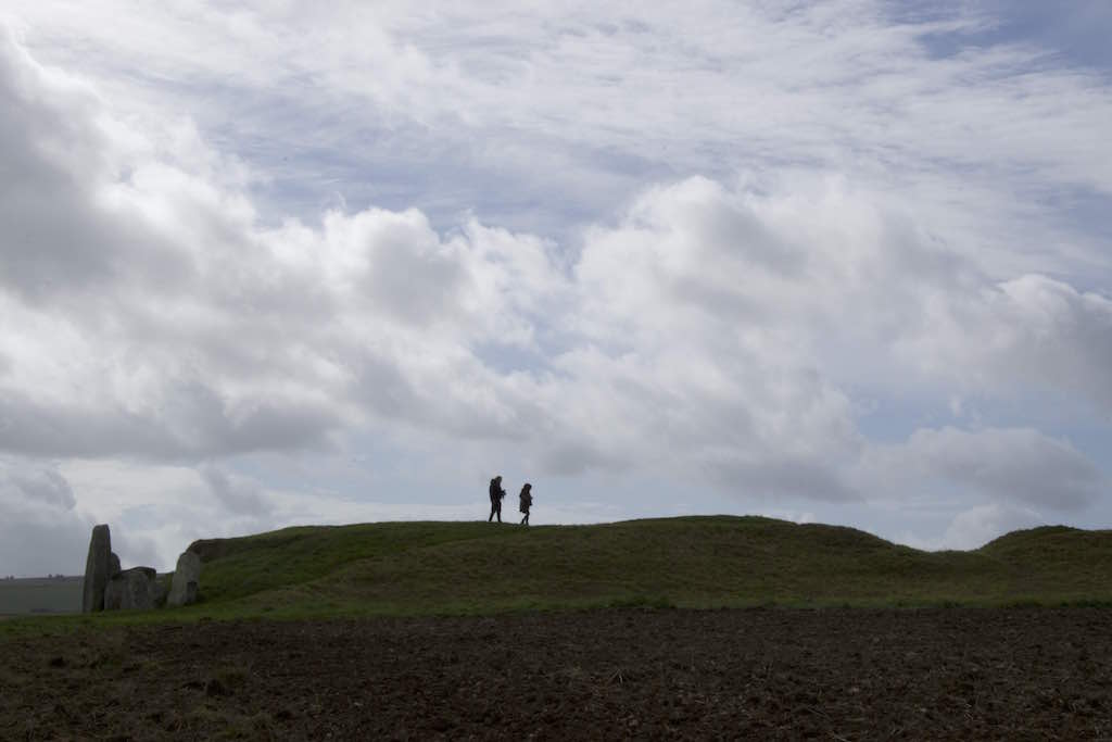
Look up to your right. Framed against the skyline is a long, low, grassy mound. This is West Kennet Long Barrow. It’s a Neolithic (Late Stone Age) communal tomb that held the remains of men, women and children who lived in this area five and a half thousand years ago and today we’re going to explore it.
The tomb was built around 3650BC, when people lived in small villages, and farmed crops and raised livestock like cattle and sheep. Although they didn’t have metal tools and lived what may appear to us to be quite humble lives, these people were clearly skilled builders able to undertake some serious construction projects! Archaeologists have estimated that it would have taken almost 16,000 hours of labour to build West Kennet Long Barrow.
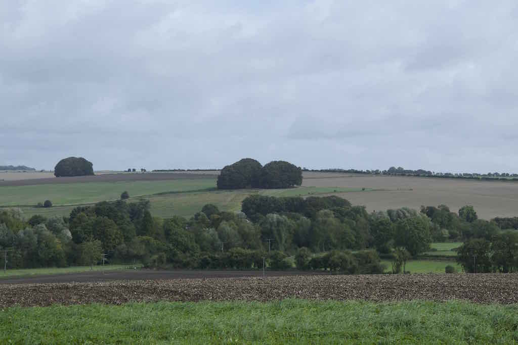
Looking at the tomb from here, it appears to be on the crest of the hill. As you climb up to it, you’ll see that it’s not actually at the highest point. But from where we are now, on the valley floor, the tomb is very distinct. The people who built the tomb and lived in the area probably spent quite a lot of time near the river and in the fertile valley we’re standing in, so it would have been a very familiar sight to them.
See if you can spot the huge stones on the left hand end of the tomb – this is the front. Notice how the earthen mound isn’t smooth, but has a dip half way along it. We’ll learn more about that once we’ve explored the site further.
Directions
Make your way up the hill, following the footpath towards the tomb. Notice how it disappears from the horizon before you reach it, then is revealed again. Once you reach the tomb, take time to explore inside and out, and walk all the way around the earth mound.
2 West Kennet Long Barrow
Chambered tombs and long barrows from the late Stone Age were like ‘houses’ for the dead, and probably mimicked the shape of buildings that living people used. Some are elongated earth mounds that once covered a wooden platform or hall, others, like West Kennet, are earth mounds with a stone-built internal chamber. These are known as megalithic tombs (mega- means large, -lith means stone in Latin). Take some time to look around, let's start with entrance...
The Front
These vast upright stones are sarsen, a type of sandstone, and were dragged here from fields a couple of miles away. When we go inside we’ll see a different kind of stone.
The stones form a very dramatic backdrop – but what you’re looking at now is actually two phases of activity. When the tomb was first built, this area directly in front of the stones (known as the forecourt) was a single curving line of megaliths, with the entrance in the centre. More than a thousand years later, the stones blocking the entrance of the tomb were erected, and the internal chambers were carefully filled with chalk and soil. It appears that this was a very grand gesture to show that the tomb wasn’t to be used anymore, or that the spirits inside needed to be closed away.
The ‘forecourt’ was used for various rituals. Archaeologists have found charred remains of fires, animal bones and pottery outside the entrance. Take a minute to imagine what rituals may have been performed here, and where people may have stood to view what was happening. Do you think this site may have been used at night as well as during the day? Now let’s go inside the tomb...
Inside
Wander round and explore the five internal chambers of the tomb . Reach out and touch the stones. How do they make you feel? Can you feel a change in the temperature and moisture in the air? Use your torch to explore, but also turn off your light and allow your eyes to adjust to the darkness.
Over a period of around 30 years, the remains of 46 people were put into the tomb. Most of the skeletons were ‘disarticulated’ – the bones had been jumbled about after the flesh had rotted away. It’s not clear whether bodies were left elsewhere for the bones to be picked clean by birds and animals, then placed in the tomb, or whether whole bodies were put in the tomb, but then moved around afterwards. Some bones appear to have been handled, especially leg bones and skulls. They may have been taken out of the tomb for use in rituals. What’s certain is that the dead weren’t left to rest in peace!
Look around you, and try to imagine who might have been allowed to go inside the tomb when it was in use. Do you think anyone could enter this place, or perhaps only special people – chiefs or shamans, for example?
There are several things to look out for inside the tomb:
In the main passageway, on the left-hand side of the entrance as you go in, is a large sarsen stone with two parallel grooves in it. By the second chamber on the left hand side is another stone with a smooth vertical groove. These are ‘polissoir’ (or ‘polisher’) stones, used as polishing blocks for special ceremonial axes. Axeheads were rubbed up and down the stones thousands of times to smooth the surface of the axe, wearing down a groove in the rock as a result. These polissoirs were used for this purpose before they were brought into the tomb. Why do you think the builders chose to incorporate this stone? Even natural objects can have important histories.
Look between the larger sarsen stones, and you’ll see sections of drystone walling. This is made from limestone, a different kind of stone to the sarsen megaliths. It was brought from an area near Frome in Somerset, up to 20 miles away. The wheel hadn’t been introduced to Britain yet, so this represents many days’ walk.
Local stone could have been used to build these small wall sections, but the builders chose to import stone from far away. Compare the sarsen and limestone – notice how neat the limestone looks, compared to the large lumpy shapes of the sarsens. The limestone is whiter - some archaeologists think the builders chose it because it’s a similar colour to human bones. Other people think the original location of the stone is more important than its colour.
Lastly, look at the roof. Layers of stones progressively overlap towards the centre to cover the roof. This is known as a ‘corbelled’ roof, and doesn’t require any mortar or timbers to hold it up. The weight of the stones holds everything in place. The skylight and concrete are modern – they were put there to help people to see the inside of the tomb a little better, and to protect the tomb from rainwater.
Along the sides
Walk around the earth mound. Look for modern kerb stones that mark the edges of the mound. Outside these, can you see the dip in the land surface and a change in the vegetation that runs alongside the length of the tomb? These are the remains of ditches that flanked the tomb. They are about 5m wide and the earth dug out of the ditches was thrown on to the mound.
See if you can spot where the ditches stop. These end-points are known as terminals, and on some tomb sites special offerings were left in them, including pieces of pottery, antler and bone. The ditches would have originally been deeper, but over time soil has slipped down, slowly ‘infilling’ them. Because the soil has been disturbed, however, and more water runs into the lower ground, you might be able to see that the grass is darker, greener, longer and there are slightly different types of plants growing along the ditch line, compared to what’s growing beyond the ditch, or on the mound.
Halfway along the length of the mound there’s a depression. Archaeologists think this was created by treasure hunters digging into the grave hoping they’d find a burial filled with gold and jewels. They were disappointed!
The Wider Landscape
The modern footpath leads up the hill at right angles to the tomb, but when it was first built and used for many generations, people may have approached the tomb from a different direction. Look out at the wider landscape - what other ways might people have approached the site? Silbury Hill, the massive mound you can see across the road was built around 2400BC, at a time when West Kennet was already around 1,200 years old. We’re not sure why Silbury Hill was built. Based on their locations, and the view of one from the other, do you think the two sites might have had been linked?
We’ll explore more enigmatic prehistoric sites nearby as we continue our walk.
Directions
Head back down the hill to the big oak tree and turn right at the fence. Follow the wide grassy path east along the field edge.
3 Flint in farmers field
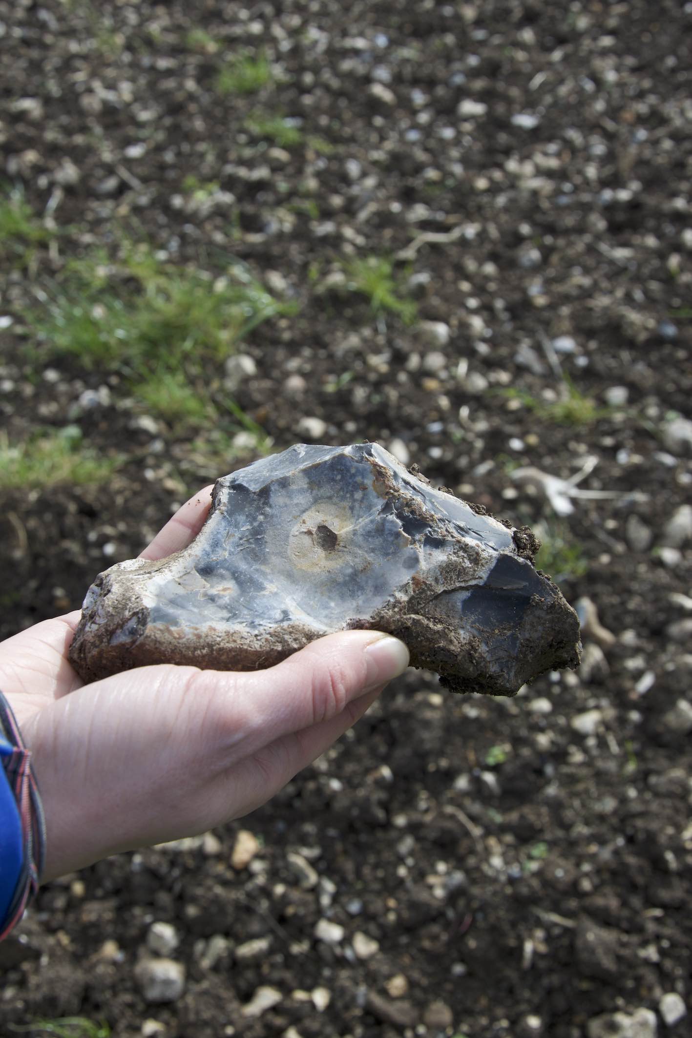
As you walk, look at the soil in the farmer’s field – can you see any chunks of flint? These occur naturally in this area, and were the raw material for prehistoric blades, axes and arrowheads.
Flint nodules naturally have a whitish-coloured rough outside layer called the cortex, and a darker, glassy-smooth interior. You may spot flint nodules that have cracked, creating sharp edges and exposing the dark colour of the stone inside.
Some of these will be natural – caused by frost or by modern farm machinery working the soil and accidentally striking the flints. But other flints may have been worked by Stone Age people – a process known as knapping. Keep your eyes peeled for evidence of flakes that appear to have been shaped intentionally, with multiple angles creating arrowheads, long blades or points.
Directions
Climb over the stile at the end of the field, head through the next field until you reach a small farm road. Cross over, head across the field and over another stile. As the field widens, take the right-hand path, to follow the hedgerow. Look around you – from here you can see Silbury Hill and West Kennet Long Barrow. To the left, look for circular clumps of trees – these are Bronze Age Round Barrows.
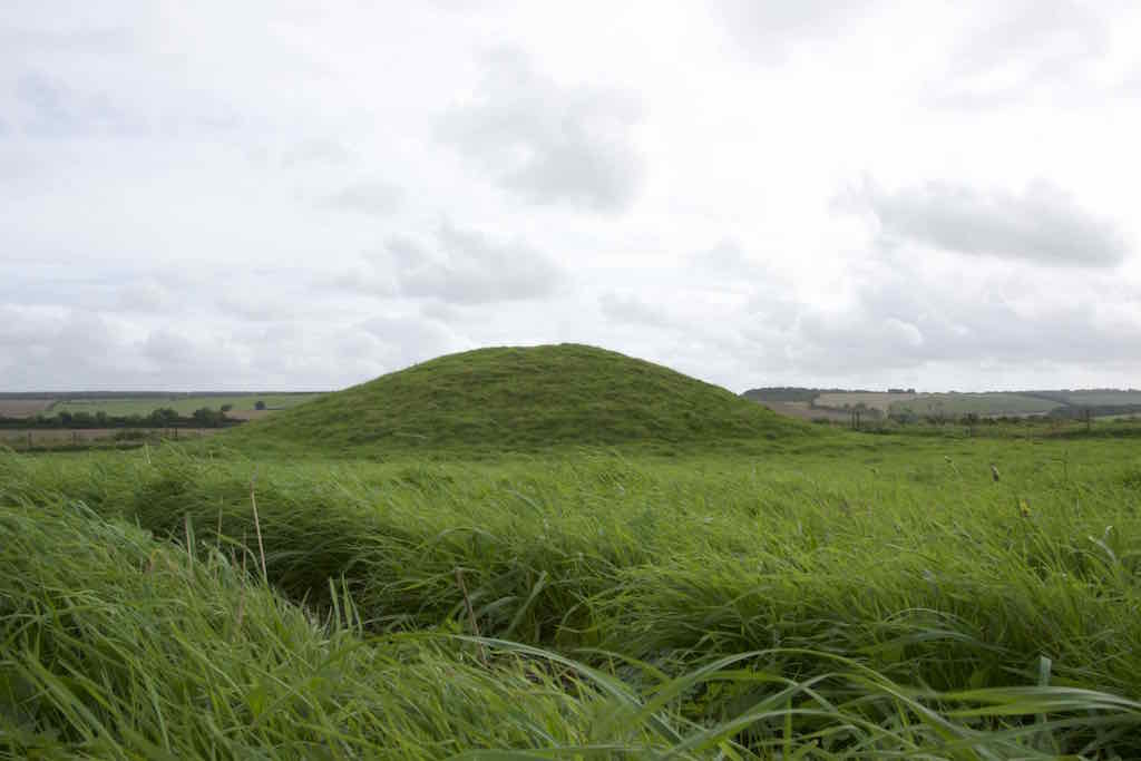
4 Round barrows
Round barrows were built from around 2400BC to 1100BC, during a time known as the Bronze Age. West Kennet Long Barrow was already more than a thousand years old when the first of these were made.
By the Bronze Age, people had stopped using communal graves, and had started to bury or cremate individuals separately, with an earth mound on top to mark the grave. On maps, these barrows are sometimes referred to as tumuli (plural; or tumulus, singular).
In more recent times, landowners planted trees on top of these round barrows to create habitats for wildlife, and to make them into quirky landscape features. Locally some people call them ‘hedgehogs’. Can you guess why?
In the fields you’re walking through, archaeologists found the remains of large circular enclosures with wooden fences that date to around 2400BC. They could have been used for gatherings, parties or religious rituals, we’re not sure. You can’t see any evidence in the fields now, but archaeologists found lots of animal bones, particularly pigs, that had been cut into joints but not necessarily eaten. These could have been animal sacrifices or ritual feasts. What’s certain is that this valley area was a busy and important site for many hundreds of years.
Directions
Climb the next stile and walk along the narrow hedge-lined path. Turn left on to the gravel track, taking care if it’s muddy, and continue until you reach the road next to the pumping station. Turn left on to the road (taking great care to check for traffic) cross the metal bridge over the river, then turn immediately right on to the marked bridleway. Skirt the bottom edge of the field, keeping the hedge on your right hand side. Look up to the left to the crest of the hill – this is your final destination. At the corner of the field you’ll meet a byway track. Turn left up the hill, for a steady 250m climb. As the path flattens out on the top of Overton Hill, look over the hedge to the right. We’ll explore the mounds you can see in a minute. In the field on the left, before you cross the busy A4, is the site of The Sanctuary. Go in through the gate.
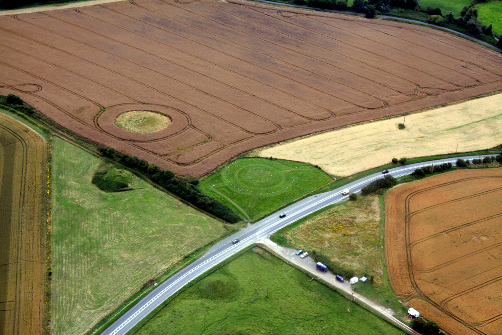
5 The Sanctuary
The Sanctuary is a mysterious monument . It was built around 4,600 years ago, at the same time as Silbury Hill and the circular enclosures in the valley. This was about 1,200 years after West Kennet Long Barrow but it might have been around the same time as the tomb was permanently blocked up.
It started off as a series of six concentric circles of timber posts. They may have been carved or decorated, and some archaeologists actually think they formed a building with a roof. At some point two circles of standing stones were raised, the larger one being about 40m in diameter. The stone circles survived until the 1720s – for more than four thousand years – but then local farmers decided to break the stones up and plough the land.
The locations of the timbers and stones are now marked by concrete blocks on the ground (red for timber, blue for stone). See if you can pick out any patterns – if you are with a group, you could get people to stand on each block, so you can get a better idea of what the monument looked like.
Some archaeologists have suggested that the wider landscape here is ‘circular’ – look out to the horizon in all directions. Does it feel like you’re in the centre of a circle of hills? Are there other points in the landscape that your eye is drawn to? How do older monuments, like West Kennet Long Barrow, fit in to this complex landscape? Check a map to see the sites of other ancient monuments.
The Sanctuary was the end (or the start depending on which way you were walking!) of a long avenue of stones that led all the way to the huge stone circles at Avebury. The avenue leads in to the north-west quarter of the circle (the far side of the field from where the gate is, closest to the road). See if you can you spot the concrete blocks that show where the avenue joins the circle.
Excavations in the 1930s revealed human bones and the remains of cooked meat and pottery at this site. It suggests the Sanctuary was used for rituals and feasts associated with death rites, although there was no evidence of human burials in the circle itself.
Directions
Exit the Sanctuary field, and head across the A4 into the field with the large grassy mounds – more Round Barrows, and the final burial monuments we’ll investigate.
6 Sevenbarrows
Some locals call this hill Sevenbarrows. The name, Seofan beorgas, first appears in a Saxon charter from the year AD972, although archaeologists have discovered that there’s actually evidence of twelve barrows!
These mounds are mostly Bronze Age Round Barrows just like the ones with the trees growing on top. There are also some later burials here, from Roman and early Anglo-Saxon times. These later burials indicate that people continued to find this area special long after the original communities had disappeared and the old belief systems had changed. The route of an old Roman road also passes through the field, parallel with the modern A4, on the far side of the barrows. See if you can spot the line of it in the grass.
Feel free to explore the mounds, although please don’t climb on them as too many people’s feet can cause damage to the archaeology below. Can you see depressions in the tops of some of the mounds? This is where they’ve been excavated. The barrows here were found to contain human remains including children, some cremated, some buried whole. Grave goods – items placed into the grave with the body – were also discovered and some of the finely-crafted flint knives, beads and arrowheads can be seen at Devizes Museum.
Standing at the top of Overton Hill, enjoy the commanding views of the landscape around you. We’ve walked through countryside that’s been special to the residents of Wiltshire for more than five and a half thousand years. Driven by the power of their beliefs, people hauled huge stones, created mounds of earth and vast circles of timber. They undertook journeys along ceremonial avenues, made offerings and performed rituals with the bones of dead ancestors.
By exploring some of the archaeological secrets preserved in the landscape, we’ve had an insight into the way people lived, worshipped and died hundreds of generations before us. The more we understand and appreciate our ancient history, the more likely we are to make sure it’s protected for future generations. Perhaps these sites will still be standing in another five thousand years, still welcoming curious souls who want to discover their secrets.
To make this a longer circular walk (adding on 5.5km), head north along the Ridgeway (which follows a Prehistoric route), after 700m turn left on to the track heading downhill, continue on this until you reach the road. Turn left into Avebury village. Explore the stone circles and massive earthworks that dominate the village, then head south via the West Kennet Stone Avenue (SU103 696), and across Waden Hill open access land to return to the A4. Take care crossing the road to get back to your car.
If you don’t want to extend your walk further, the most pleasant route back to the start point is to retrace your steps, enjoying more views of the ancient landscape around you.
Your browser is out of date, and unsupported by this website. Please upgrade to the latest version to use this website.
Welcome to one of the most complex and intriguing prehistoric landscapes in Britain.
Explore the graves of our ancient ancestors, walk in the footsteps of people who lived here more than 250 generations ago, allow the magic and mystery of this ancient landscape to work its magic on you.
On this trail, writer and presenter Mary-Ann Ochota guides us through almost 6,000 years of history.
Follow the trail by clicking on the map pins or downloading the guides below
West Kennet Long Barrow, near Avebury, Wiltshire, SN8 1QH
Grid reference:
SU 10363 68362
Start point:
Layby along A4, between Beckhampton and West Kennet
Finish point:
Overton Hill Car Park, off the A4, on the Ridgeway National Trail
Directions from parking:
With the road behind you, head to the left-hand corner of the layby, through the kissing gate. Follow the gravel path for 250m, crossing a small bridge and through another wide kissing gate. Turn left and head towards the large oak tree.
Be prepared:
Bring a torch to help you explore the chambers inside the tomb
Keep an eye out for:
Ribbons tied in trees along the way, left by modern people who believe these ancient sites remain spiritually important.
 Looking at the tomb from here, it appears to be on the crest of the hill. As you climb up to it, you’ll see that it’s not actually at the highest point. But from where we are now, on the valley floor, the tomb is very distinct. The people who built the tomb and lived in the area probably spent quite a lot of time near the river and in the fertile valley we’re standing in, so it would have been a very familiar sight to them.
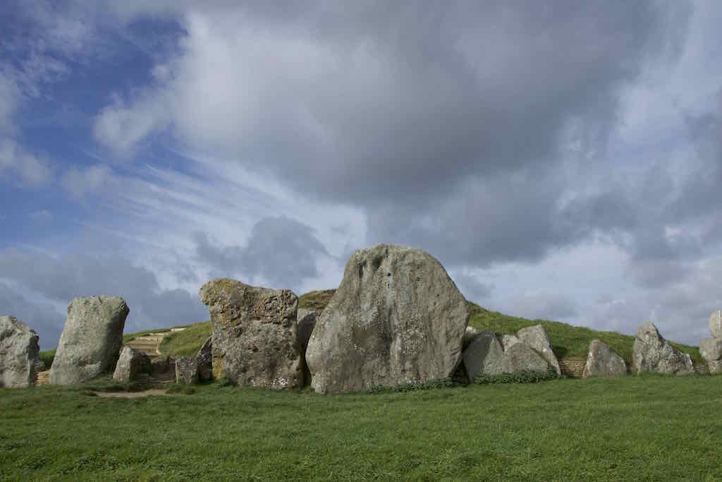


 In the main passageway, on the left-hand side of the entrance as you go in, is a large sarsen stone with two parallel grooves in it. By the second chamber on the left hand side is another stone with a smooth vertical groove. These are ‘polissoir’ (or ‘polisher’) stones, used as polishing blocks for special ceremonial axes. Axeheads were rubbed up and down the stones thousands of times to smooth the surface of the axe, wearing down a groove in the rock as a result. These polissoirs were used for this purpose before they were brought into the tomb. Why do you think the builders chose to incorporate this stone? Even natural objects can have important histories.
 Look between the larger sarsen stones, and you’ll see sections of drystone walling. This is made from limestone, a different kind of stone to the sarsen megaliths. It was brought from an area near Frome in Somerset, up to 20 miles away. The wheel hadn’t been introduced to Britain yet, so this represents many days’ walk.