According to legend, the 5th century saw Britain ruled with chivalry and honour by its noblest king - Arthur. Arthur, his trusty knights and the magician Merlin remain an evocative part of British culture. Their adventures still inspire books, songs, films and TV shows.
Over 100 places in Britain claim physical links with the mythical monarch, yet the small village of Tintagel has become the centre of all things Arthurian. Today Tintagel is internationally famous as Arthur’s legendary birthplace. There are references to him everywhere, from shop names in the main street to a ‘footprint’ he left in the cliffs.
This building, King Arthur’s Great Halls, illustrates his influence. Visitors can see Arthur’s throne, the knights’ Round Table, browse an Arthurian library and even enjoy an Arthur-themed laser show. In Tintagel, King Arthur is more than a myth; he’s a pillar of the economy.
But it wasn’t always this way. The Great Halls, for example, were inspired by the ideals of Arthurian chivalry. From the 1920s this was the home of the Order of the Fellowship of the Knights of the Round Table. This idealistic group welcomed people from all backgrounds and promoted “virtuous behaviour”.
It’s ironic that Arthur has become a more commercial figure. But this shift highlights that Tintagel has another story. Before tourism took off, the village survived through other sources of income.
Let’s begin our quest for them…
Pictures:
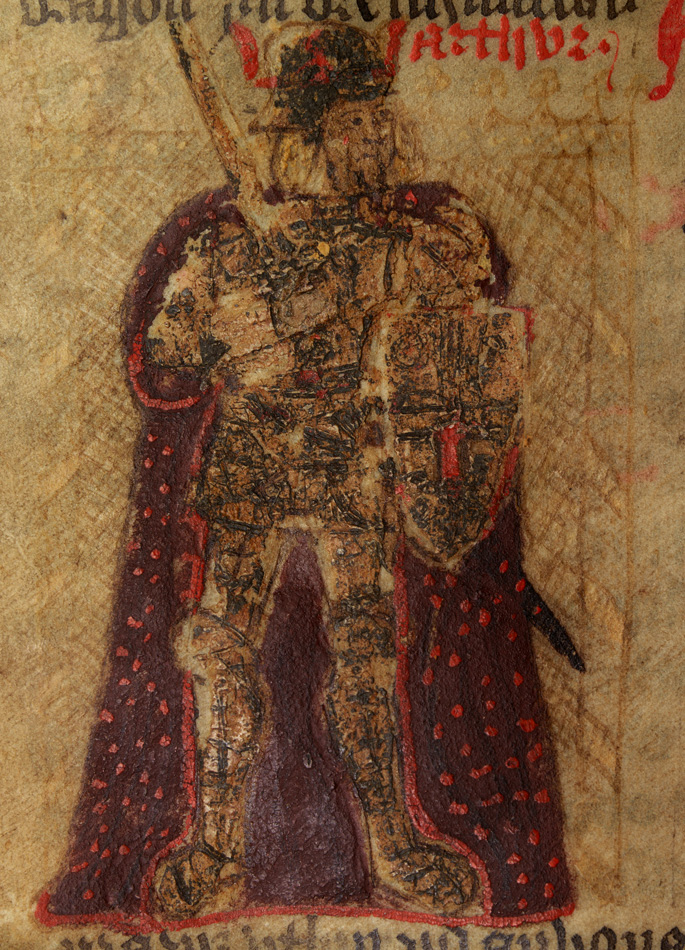
King Arthur in a 15th century copy of Geoffrey of Monmouth's Historia Regum Britanniae Wikimedia Commons (CCL)
With the Halls on your right and road on your left continue along Fore Street. Keep an eye out for Arthurian references along the way. Carefully cross the car park entrance and stop outside the King Arthur’s Arms pub. Look across the road at the building opposite, the Old Post Office.
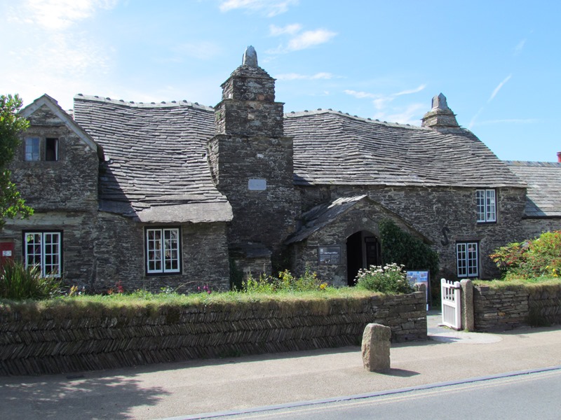
2 Tintagel Old Post Office, Fore Street
Tintagel Old Post Office contains many clues to the village’s story. Like several other buildings on this street it dates from the 14th century. Notice the wavy roof and ‘herring-bone’ garden walls. These are made of slate, something we will explore later.
Originally this was a ‘longhouse’, a farm building with a room for keeping animals. Farming is one of Tintagel’s oldest livelihoods. The village grew around a 5th century monastery and the surrounding estate provided ideal farmland. Crops, cattle and sheep still thrive in the fields because the sloping hilltops let rainwater drain naturally through the soil.
This building was a Post Office from the 1870s to 1892. Though this role was short-lived, it changed the village’s fortunes forever. Until the mid-19th century the village was called Trevena. ‘Tintagel’ referred to the nearby castle and coast. This all changed when the area became a Victorian visitor attraction.
The story began in the 12th century when historian Geoffrey of Monmouth wrote that King Arthur was born at “Tintagol”. Geoffrey’s account encouraged others, including Thomas Mallory’s 16th century Le Morte d’Arthur. Such writings led poet Alfred, Lord Tennyson to visit Tintagel Castle in 1848. The dramatic landscape inspired him to write Idylls of the King, a series of long narrative poems about King Arthur’s life.
These poems made Tennyson and Trevena world famous. As the Victorians’ interest in Arthur and his ‘birthplace’ grew, the Post Office adopted the name Tintagel. It soon applied to the whole village. It’s fitting that Tintagel’s name was delivered by the mail, as this place is highly indebted to written words.
An 1869 portrait of Alfred, Lord Tennyson, Wikimedia Commons (CCL)
Directions
Continue along Fore Street with the road on your left. Just before the road bends to the right, carefully cross over and take the path downhill past the Tintagel Castle sign. The descent is steep in places so take your time. When the path forks, take the left fork (the right fork is for vehicles).
The forks merge again by a stream on the left. Continue along the shared path and pass a noticeboard about the Castle Track. After a short distance, stop on the path by the ruins of a small stone building beside the stream.
3 Remains of Borough Mill
The approach to Tintagel Castle can be very busy but take a moment to step out from the crowds and take in the surroundings.
Before the written word, Tintagel’s fortunes were shaped by its natural landscape and location. This spot offers a good example.
Notice how far we have descended from the village. Tintagel’s original name, Trevena, is Cornish for ‘mountain settlement’ and reflects its location above coastal cliffs. ‘Tintagel’ meanwhile comes from ‘fort’ and ‘throat’ and refers to the castle’s site on a narrow (throat-shaped) headland, Tintagel Island.
The ruined castle looms on the left horizon. From here we can see its ideal defensive site. The high, coastal position is difficult to reach, easy to protect and with expansive views. Yet Tintagel never saw military action. Instead it was a picturesque folly. It was built from 1233 for Richard, Earl of Cornwall who wanted an “ideal castle” inspired by the Arthurian myths.
The castle wasn’t the only building that took advantage of the landscape. Look at the stone walls next to us. These are the remains of an old mill.
Notice how the path we are on follows a stream that flows downhill into the sea. The stream emerges at the edge of the village, where the soft farmland meets the hard coastal rock. As water cannot drain through the rock it springs to the surface.
The mill was built here in the 13th century to harness the fast-flowing stream. It ground corn from the local farms and worked until the 1860s. By then other industries were underway at Tintagel. And again the natural landscape helped people make a living.
Postcard of the mill in the 1890s, Wikimedia Commons (CCL) Click on the image to enlarge
Directions
Continue along Castle Track with the stream on your left and head towards the white buildings. Notice a large building on the hilltop to the right. Cross the stream over a stone bridge and pass the Tintagel Castle shop and toilets. Continue to a set of wooden railings overlooking the coastline.
Turn right at the railings, cross the stream again over another stone bridge and immediately turn left. Follow the path round and stop at the wall by another set of wooden railings. From here, look over the water at the cliff below Tintagel Castle.
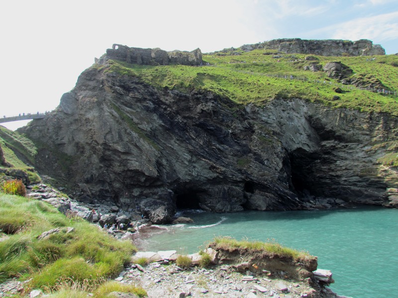
4 Railings overlooking Tintagel Haven
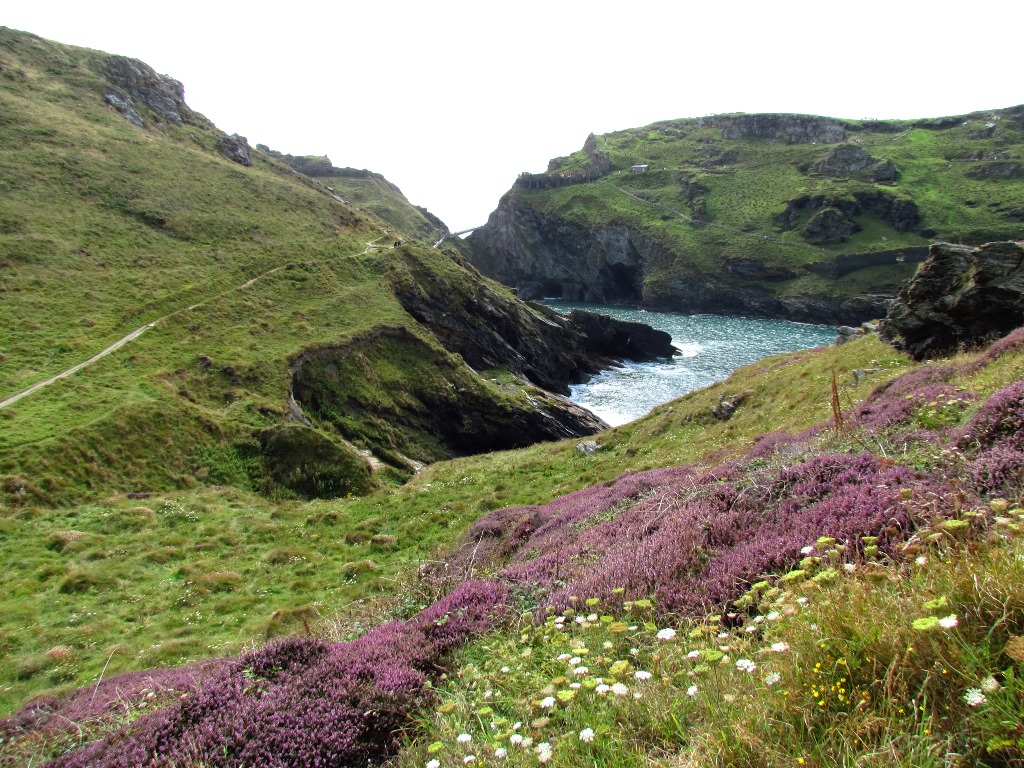
This small cove is Tintagel Haven. From here we can appreciate how Tintagel Island juts out into the sea. It’s not a true island as it is still attached to the mainland.
The castle is in two sections, separated by a wide gorge. Access today is by footbridge. Like the corn mill, the gorge owes its existence to water power.
Waves pound Tintagel's cliffs and gradually break them up in a process called erosion. Erosion sped up the castle’s decline. As the gorge widened and parts of the castle tumbled into the sea, it was abandoned. Eventually erosion will cut off Tintagel Island completely.
Centuries before the castle was built Tintagel Haven was a fishing harbour. Archaeologists have found remains of ancient sea trading here. Fragments of Mediterranean pottery dating from 300 AD suggest merchants from Italy, Greece and Turkey traded wine and oils. Can you spot what they might have taken home in exchange?
Look closely at the cliffs for diagonal stripes. These are layers of slate, which forms in thin sheets. Around the Haven you’ll see bits scattered like broken plates.
As we saw at the Old Post Office, slate was used to tile the village. It was also exported far beyond. By the 18th century there were several large slate quarries around Tintagel.
Now look on the shoreline for clues to another export. The large hole to the left is Merlin’s Cave, where in Tennyson’s poems Merlin saved baby Arthur from drowning. The cave was carved by the sea but other holes nearby weren’t. To the right and slightly above it is a tunnel (or ‘adit’) for a mine.
Rocks contain natural minerals. At Tintagel silver was discovered and mined in the cliffs. The café and toilets we passed are former mine buildings while the nearby rusty winches loaded slate and silver onto waiting boats. Also notice the sea’s colour – minerals in the water, including copper, create a bright green tint.
With the wall on your left, go up a set of stone steps. The steps curve round to the left to an old metal winch. Go up another set of steps to the right of the winch. At the top of these is a signpost for the coast path.
Turn left and follow the path upwards along the side of the cliff. Take great care as the path is uneven in places. There are steps and wooden railings to help you. Follow the coast path as it bends to the right. Stop when you reach a square stone on the right, standing upright with writing carved on it.
5 National Trust marker, Barras Nose
We are now on the way to the next headland, Barras Nose. This quirky name may come from the coastline’s bulbous shape. Earlier we explored how these cliffs were quarried but this stone tells a different story. Take time to read the inscription.
The poem isn’t by Tennyson but Thomas Hardy. Tennyson’s success inspired other Victorian writers and artists to visit Tintagel. And they were only part of a growing phenomenon. In 1893 a railway line was built to Camelford, about 6 miles away. The line opened the north Cornish coast, including Tintagel, to mass tourism.
The trains arrived as some of Tintagel’s industries departed. By the 1870s the corn mill and the mine had ceased working. The amount of silver in the cliffs was small and difficult to extract. Slate quarrying remained but declined after the Second World War, partly because of cheaper European imports. Mining and quarrying were also very destructive and left their marks on the landscape.
Tourism provided a welcome boost but concerns soon grew that the coast could still be spoilt. Besides the noise and crowds, some visitors bought Cornish choughs - native seabirds - as pets. So to protect the coast and its wildlife from possible development, locals bought Barras Nose. They paid £505 but the unspoilt views we can still enjoy today are priceless. In 1896 Barras Nose was given to the National Trust, becoming its first coastal ‘property’ in England.
Continue along the coast path with the sea on your left. As you go, look for other stones in the ground inscribed with sections of poetry. Barras Nose headland will appear on the left, with a large sea cave worn into the bottom of the cliff.
Continue across a small wooden bridge over a brook. When you reach a post (marked ‘Barras Nose ¼ mile’) the path forks. Take the left fork and continue along the path up some slate steps.
As you continue around the headland of Barras Nose, look for a wooden bench on the left, just off the main path. When you reach it sit down and enjoy the view!
6 Bench on Barras Nose facing Tintagel Island
Take in the romantic ruins of Tintagel Castle perched out to sea; Merlin’s Cave gaping at the jagged shore; the Haven’s bright water coloured by minerals; the steep grassy banks speckled with slate.
This spectacular view provides a visual summary of the landscape we have explored. This place is still full of the drama that appealed to Richard the Duke of Cornwall, inspired Victorian poets and helped to forge links with King Arthur.
The Arthurian myths can almost blot out the village’s other stories but today we have explored some of them. We discovered how Tintagel’s location and natural landscape helped people make a living, how the village economy changed and how its scenery became protected.
Up here on Barras Nose feels a world away from the commercial realm of Arthurian tourism. But turn away from the Island and look to the left horizon for a large square building with castle-like turrets.
It’s a hotel opened in 1899 for Tintagel’s growing visitor numbers. The planners wanted to build it directly opposite Tintagel Castle, much closer to this bench and probably spoiling the view.
Protest over development and the coastline’s protected status meant the hotel was built further inland. Today the building is a reminder that this landscape has always been exploited in some way; whether through farming, fishing, mining, grinding corn and quarrying slate.
The Arthurian visitor economy is the latest chapter in an epic journey. And what would have happened to Tintagel without King Arthur? Would so many people enjoy exploring the Castle, visiting the village or walking the coastal path?
The interest and income that King Arthur generates help to preserve Tintagel’s landscape and community. As Tennyson wrote in ‘The Coming of Arthur’, “Strike for the king and live!”
Pictures:
King Arthur and the knights of the Round Table see a vision of the Holy Grail (c1475), Wikimedia Commons (CCL) Click on the image to enlarge
From the bench you are about half a mile from Tintagel village. You can retrace your way to the village by following the coast path back to Tintagel Haven. To avoid walking up the steep hill to Fore Street, you can take the National Trust Land Rover taxi service from the café.
Alternatively, you can return to the village by following the paths on Barras Nose towards the hotel. They lead to a steep uphill path that passes just left of the hotel and takes you through a wooden gate.
At the top join the road outside the hotel driveway (Atlantic Road). Follow Atlantic Road, taking the right turn lined with houses. You will emerge at the end of Fore Street.
Your browser is out of date, and unsupported by this website. Please upgrade to the latest version to use this website.
A walk along the South West Coast Path to King Arthur's birthplace
Romantic castles on dramatic cliffs, noble knights and cunning conjurors, clashing swords and crashing waves – Tintagel is tied into the legend of King Arthur.
The castle is said to be Arthur’s birthplace and Tintagel’s heady mix of mythology and scenery mean this small village draws almost 200,000 visitors a year, from all around the world.
But there are lesser-known stories behind the famous myths. This trail explores how Tintagel became linked with King Arthur and the forces that shaped the village’s fortunes before then.
Follow the trail by clicking on the map pins or downloading the guides below

") The story began in the 12th century when historian Geoffrey of Monmouth wrote that King Arthur was born at “Tintagol”. Geoffrey’s account encouraged others, including Thomas Mallory’s 16th century Le Morte d’Arthur. Such writings led poet Alfred, Lord Tennyson to visit Tintagel Castle in 1848. The dramatic landscape inspired him to write Idylls of the King, a series of long narrative poems about King Arthur’s life.
The story began in the 12th century when historian Geoffrey of Monmouth wrote that King Arthur was born at “Tintagol”. Geoffrey’s account encouraged others, including Thomas Mallory’s 16th century Le Morte d’Arthur. Such writings led poet Alfred, Lord Tennyson to visit Tintagel Castle in 1848. The dramatic landscape inspired him to write Idylls of the King, a series of long narrative poems about King Arthur’s life.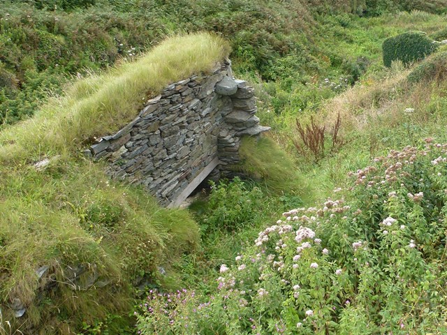
")
 Look closely at the cliffs for diagonal stripes. These are layers of slate, which forms in thin sheets. Around the Haven you’ll see bits scattered like broken plates.
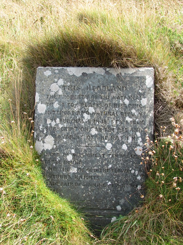

 Wikimedia Commons (CCL)")
