Stood atop a rugged clump of sand in Studland, you are peering across Poole Harbour to Sandbanks’ shiny shores.
These two headlands couldn’t look more different. One is natural heathland and the other lined with some of the UK’s – indeed the world’s - most expensive real estate. But their original names of South Haven and North Haven give the hint that they used to have more in common than today.
To our left is Poole Harbour – one of the largest natural harbours in the world. The South (Studland) and North (Sandbanks) Haven peninsulas are relatively ‘new’ areas of land. They are both ‘spits’ –stretches of sand which extend into the sea from the mainland. They were formed through a process called ‘longshore drift’. Sand and sediment are dragged along the coast and then deposited, forming the land you are now standing on.
North Haven is made of quartz sand which comes from the cliffs further to the east from here at Bournemouth. Waves and wind acted like sandpaper on these rocks, breaking off small particles. These particles were transported in the water and gradually deposited at North Haven (or Sandbanks as we know it today). In a similar way, South Haven gained some sand from cliffs to the south.
So why are these two spots so different?
Bournemouth’s cliffs and Poole’s bustling port hold the secrets.
Spits continually shift and change. If nature had its way, Sandbanks would be moving in a north-easterly direction (into Poole Harbour). As more sand gets deposited, the wind and waves would push the spit backwards. However sea defences in Bournemouth, built to protect the town from erosion, mean the spit no longer receives sediment from this direction. So Sandbanks has become stable, staying in the same position for years.
Sandbanks was also affected by changes to Poole Harbour.
Poole became an important port from as early as the 1200s. Poole’s size meant it thrived, while other smaller ports in the harbour succumbed to silt and sand deposits in their shallow waters. As Poole grew in importance, access became vital and in 1890 thirteen groynes (stone walls jutting into the sea) were constructed in the harbour. The groynes collected sediment that would have been carried along the coast, preventing longshore drift. This kept Poole harbour open while Sandbanks got the benefit of the extra sand.
As a result Sandbanks grew in size, making it ripe for development! Its proximity to both Poole and Bournemouth enticed buyers and builders - and left Studland free from development. In fact Studland’s owners were not interested in developing real estate. They even turned down an approach from Billy Butlin to build one of his famous holiday camps here!
Directions
Walk away from the harbour along the beach with the sea to your left. Continue along the coast until you can clearly see a line of red posts stretching out into the sea.
2 Longshore drift on Studland beach
Gazing out into the sea, a row of higgledy-piggledy posts and smart red poles line the view. But what are they? And what do they tell us about the relationship between Studland and Sandbanks?
Remember how the two ‘spits’ were formed? The process of longshore drift created the land that developed as Sandbanks (North Haven Peninsula). But at Studland (South Haven Peninsula) it isn’t quite so clear cut.
Longshore drift isn’t actually a major factor here. Look to the right and at the far end of the beach you will see it curves round to reach several white rocky outcrops. These are Old Harry’s Rocks. They are the remains of a solid line of chalk that once stretched all the way to the Isle of Wight, now worn away by wind and waves. When chalk erodes like this it doesn’t produce sand, as the calcium carbonate in the rocks dissolves rather than breaking off into sand-sized particles.
Though these cliffs haven’t contributed much to Studland beach, some sand is transported from the lower cliffs of South Beach and Middle Beach (visible round to your right). This is the reason for the posts you can see in the water.
In 1924 a bank of rocks was laid from the end of the Studland Peninsula out into the sea. This ‘training bank’ forms an underwater barrier. It cleverly directs the ebb and flow of tidal currents to stop sand collecting in the entrance to Poole Harbour. The red posts simply mark this line to ensure boats navigating the harbour know where to avoid!
Directions
Continue to follow the shore line with the sea on your left.
Turn right into the dunes when you see a purple-topped wooden ‘Heather Walk’ post on the dune-line.
Stop just as the sand begins to rise up off the beach and grasses start to appear in the sand.
3 The embryo dune
Here we are standing on the cusp between dune and beach. As you walk through the dunes you are about to enter 400 years of history. .
The process of longshore drift brought some of the sand here but for sand dunes to form, the wind also plays a part. Blowing in from the east, sand collects around any obstacles in its way – rubbish and rocks are often the culprits. Such obstacles mean the sand builds up into mounds.
Depending on the wind conditions, you might be able to spot the first signs of a brand new mini-dune. Can you see small hummocks of sand covered in tall, spiky grasses? Eventually ‘pioneer species’ of plants like these start to colonise, binding the sand together. This first stage is called an ‘embryo dune’.
The conditions on the frontline of the beach are harsh. The sand is very acidic and salty, there are virtually no nutrients, and the winds can be high. The plants must be robust to cope. They have long roots so they can search for freshwater deep below the salty environment, which also helps to anchor the dune to the landscape.
Behind this new creation however are three more sand dunes, each one progressively older. Each started life as an embryo dune, but over time as new sand was deposited on the beach, a new one formed in front of the last. This is how the land has built up on this peninsula.
Each dune has their own character, gaining more stability and vegetation as they get older. Standing here we are at the newest end of the sand dune story. As we walk back through the dunes we will uncover how an embryo dune becomes a ‘yellow’, then a ‘grey’, and finally a ‘climax’ dune – quite a colourful tale!
Directions
Follow the marked path through the divide in the sand dunes.
Stop when you can see a clearing between sandy heathland and trees that line the view in front of you – there should be a fence on your left hand side.
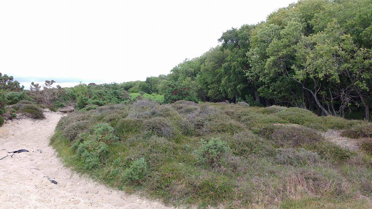
4 Sand dune succession, North Boundary Track
Heading away from the coast, we seem to be trudging over the dunes towards what looks like heathland and forest. But this is actually another sand dune!
As more dunes gradually arrive on the beach from sand brought to the bay by the wind, older ones become more established further back on the peninsula. The dunes you are standing in now are a perfect example of how this happens and how important each dune is to the habitat and landscape.
We found the first signs of life on the embryo dune, and have now walked through two other dunes to get here.
After their first colonisation by deep rooted grasses, nutrients build up. These help retain rain water better and make the dune less acidic. Older dunes are therefore able to support more varied plant life. A good example is Marram Grass. These plants have the deep roots to access freshwater and secure the dune, but also grow very quickly. Their long spiky leaves can trap even more sand and help the dune to grow.
The dune is still mostly made of sand though, so we call them Yellow Dunes (or Fore Dunes). This type was the first dunes you walked through off the beach.
Behind these Yellow Dunes are the Grey Dunes. As the Marram Grass dies, it decomposes to form an earthy layer of something called humus – not to be confused the garlicky chickpea dip Hummus. This gives the dune a grey colour, hence the name. Humus also helps to stabilise the soil making the dune a more permanent feature of the landscape.
These aren’t the only names these dunes have though. At the beach, the first ‘fore’ or ‘yellow’ dune is also called Zero, the next one back is One, where we stand now is just behind Two, and finally you will cross Three. Each dune represents a hundred years of history. But what happens when the next embryo dune takes hold…will we call it minus one?!
The current sand dune naming system was created in the 1930s, by Captain Cyril Diver. As each dune takes 100 years to form, there wasn’t a foreseeable successor to the Zero dune that Diver classified. Diver’s number system is also an interesting reflection of how the landscape was regarded in the 1930s. At that time, many would have thought of the natural environment as a finished product, rather than today’s understanding that the landscape is a work in progress!
But Studland is also a vital natural habitat for what grows between the dunes. And you are standing in it right now!
To have peaks, you must also have troughs. In sand dunes these depressions are called ‘slacks’. As they are much lower than the peaks of the dunes, they are much closer to the freshwater and nutrients that lie beneath. What does this mean?
Well, look around for patches of purple and deep green heathland. The slacks provide the perfect level of nutrients and acidity for heathers to flourish. This is a fragile and unique habitat, however. At our final stop we will explore how it is preserved.
Directions
Continue on the path, following it further into the dunes. Stop when you reach the end of the track in a clearing next to the main Ferry Road.
5 Heathland, North Boundary Track
You have just left the forest of the ‘climax dune’. As the oldest dune on the peninsula it has been colonised by grasses, heathland and now trees – birches, willows and pines. You may also have noticed ponds on your stroll to this point. These show just how much life and water can be sustained as the sand dune gets older.
You have also walked through the purple hues of heather, spiky grasses and low-lying vegetation clinging to the sands below. This is the most threatened habitat on the peninsula – dune heath. Most heathlands are man-made, created through clearing forests and grazing the land.
Heathland can date as far back as the Bronze and Iron Ages (nearly 4,000 years ago!). There is an example on the other side of the Ferry Road where you stand now.
This heath however is natural. It is the only example of dune heath in the South West of England.
Dorset heathlands are home to all six native British reptile species (grass snakes, smooth snakes, adders, common lizards, slow worms and sand lizards) as well as a plethora of insects and rare plants. Its soils are low in nutrients and very acidic, so its biodiversity is often very concentrated and even more important to our British ecosystem.
So you might imagine that the barbed wire you passed on the way was to keep people out. In fact it is to deter cattle.
Here, even next to the beach, are small numbers of cattle grazing over a large area – a strategy called extensive grazing. This has been introduced to help reduce the number of trees sprouting up which would easily block out the sun and take nutrients away from the heathland plants.
There are even experiments with new forms of cattle management – underground currents that keep the cows in a designated area while allowing other wildlife, and in some places people, to roam un-hindered. It is this careful management on the South Haven peninsula that will enable the dunes to flourish.
Emerging from four hundred years of dune-making, biodiversity and land formation, we arrive next to the road that leads visitors back towards the bright lights of Sandbanks. Hopefully the differences that make both peninsulas unique have become clear.
One is held in place by costly coastal management and able to support some of the most lucrative housing in the UK. The other is managed carefully to preserve its natural history and provide a haven for wildlife and sand-seeking visitors alike.
Although both jut into Poole Harbour’s shallow waters (and are just 321 metres apart) the shifting sands that formed them have created two distinct worlds.
Your browser is out of date, and unsupported by this website. Please upgrade to the latest version to use this website.
A walk on the South West Coast Path by Poole Harbour
Have you ever wondered why two places that started life in the same way end up completely different?
Gaze from South Haven peninsula across to neighbouring Sandbanks and you might ask this very question. While one is a rugged sandscape of dunes and heathland, the other’s skyline sparkles with white-washed condos and glamorous yachts.
This trail walks through centuries of coastline to uncover how these two sister headlands developed and how their unique environments are being preserved.
Follow this trail by clicking on the map pins or downloading the guides below
Sandbanks Ferry car park, Ferry Road, Studland BH19 3BA
Finish point:
North Boundary Track, Ferry Road, Studland BH19 3BA
Grid reference:
SZ 03543 86391
Practical information:
Free parking available along Ferry Road. In the peak of summer this can get very busy. National Trust members can park for free in the car park at the end of this road before the ferry terminal.
Keep an eye out for:
Pieces of coal along the beach opposite Sandbanks – it washes up from a ship sunk here in the 1940s to keep German U-Boats out of Poole Harbour
Directions to start:
Walk along Ferry Road towards the chain ferry port. Just before the payment kiosk you will see a car park and toilet block on your right. You will find a footpath signposted from the back of the car park. Follow this along boarded walkways. Stop when you reach the beach. Climb up onto one of the mounds of grassy sand to get a better view.
Studland trail credits
Thank you to -
Jo Kemp and David Kemp for creating and photographing this trail
Rory Walsh and Caroline Millar for advice and editing

 and Jo Kemp")