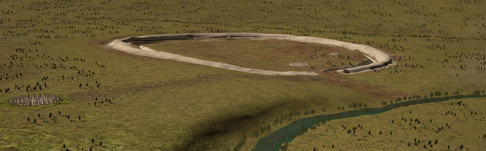
Can you see the curving line of a rough grassy bank 300m ahead of you, arcing round to the right, across the whole of the field? Look across the main road (the A345) and you’ll be able to trace the bank continuing through the opposite field. This is Durrington Walls - the largest henge in the world. It was built around 2500 BC in the Late Stone Age (the Neolithic). It measures nearly 500 metres across and is the size of nineteen rugby fields.
But what exactly is a henge and why is it so important?
Henges are circular monuments with a bank on the outside and a ditch on the inside. Like our modern day theatres, cathedrals or football matches they were ceremonial places where large gatherings of people could join together to celebrate special occasions and rituals.
Although you can’t see any remains now, the centre of the henge was once a busy and important place for our Neolithic ancestors. We’ll find out more about the history of the henge in a moment.
The Neolithic people who built Durrington Walls dug the whole thing with pickaxes made from deer antlers, shovels made from cow bones and wooden and stone hammers. It would have taken thousands of hours of back-breaking hard labour.
Directions
Walk north, downhill, into the henge earthworks, and take your time to explore this section of the circle, and get a sense of the size and scale of the monument.
2 A closer look
Take a look at the reconstruction showing what Durrington Walls might once have looked like and try to imagine it in front of you.
The ditch was originally much deeper - 6 metres deep and 5 metres wide. The earth and rock dug out from the ditch was used to build a bank 3 metres high. The bank and ditch are lower now because over the centuries soil has slipped down, lowering the height of the bank and slowly filling the ditch.
Originally, the steep banks would have been stripped back to the chalk bedrock – so the whole henge would have stood out, shining white in the landscape.
But what you can see now is only one phase of a complex landscape that has important links with its neighbour Stonehenge.
Around 2500 BC people built a huge village where the henge now stands. Hundreds of round huts with hard earth floors, wooden frames and thatched roofs provided homes for thousands of people. It’s thought that these were the people who built Stonehenge, recruited from far and wide.
This Durrington village was unusual – not only did it house the people who built one of the most complex prehistoric monuments in the world – Stonehenge – it also appears to have been a centre for feasting and parties!
In rubbish dumps near the houses, the bones of hundreds of pigs were found. Some of the pig carcasses had stone arrowheads shot into their feet and legs. Hunting with arrows isn’t the usual way farmed pigs were killed for meat, so maybe this is evidence of a ritual hunt, performance, or some kind of game. The huge number of barbequed pig carcasses suggests that large groups of visitors gathered at the village for special occasions.
Archaeologists have also unearthed a pathway that led down to the River Avon – you can’t spot it in the landscape anymore, but have a look at the map and see how close we are to the winding course of the river.
If you trace the line of the river south and around Amesbury town, you eventually reach West Amesbury. Pick out the line of the earthwork marked on the map as ‘The Avenue’. It hooks round in a north, then west, then south-westerly arc to arrive at Stonehenge itself. This was the ceremonial route that Neolithic people took to reach the monument.
If we time-travelled back to 2500 BC, we may find that people considered the monuments and activities at Durrington Walls just as important as what happened at Stonehenge itself!
The central stones at Stonehenge are aligned for Midwinter sunset. It’s possible that rituals began here at Durrington at Midwinter sunrise, and then a procession made its way along the river and to Stonehenge in time for sunset.
After just a decade, the village at Durrington fell out of use. Some time later, a huge circle of vast wooden timbers was erected in a circle about where the earth banks are. These huge tree trunks may have been up to 5m high, and weighed up to 3 tonnes each. The whole circle would have required 300 mature trees to be felled and dragged to the site.
Not long after the circle was created, the timbers were carefully removed, and may have been used to build another circle closer to the road where the cars are parked. It was only at this point that the henge earthworks were constructed.
We don’t know why there were all these different phases of activity. Perhaps new leaders demanded new monuments. Or maybe a change in religious beliefs meant the henge had to be altered. Research is still underway – the story of Durrington Walls is still being written!
Directions
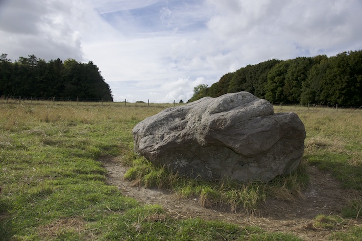
Head to the southwestern corner of the field, and walk back towards the road. Cross the road and enter the field opposite. Follow the path south towards a low boulder nestled in the grass. This is the Cuckoo Stone.
3 Cuckoo stone
This fat, lumpy boulder is sarsen, a hard sandstone. It’s the same kind of rock used at Stonehenge for the largest stones. In the Stone Age, it was stood upright as a standing stone.
Around 2000 BC, in the Bronze Age, the Cuckoo Stone became a focus for cremation burials – three pots containing human ashes were placed in a line south of the stone. More than 2,000 years later, ancient Romans dug pits nearby and built a rectangular shrine to make offerings and pray to statues of their gods and goddesses.
Take a careful look at the surface of the stone – you’ll notice areas are smoothed and polished. We don’t know when it was knocked over, or fell over, but this evidence indicates that it must have been lying on its side for many hundreds of years, allowing rainwater to pool on its surface and erode areas away. The hands of visitors touching and rubbing the rock has smoothed sections too.
We don’t know why the location of the Cuckoo Stone was important, but it stands on the direct line between Durrington Henge and Stonehenge. It’s thought that it got its quirky name because sarsen stones are quite rare in this area (referring to the habit of the cuckoo laying its eggs in the nests of other birds that then raise the chick as their own).
Directions
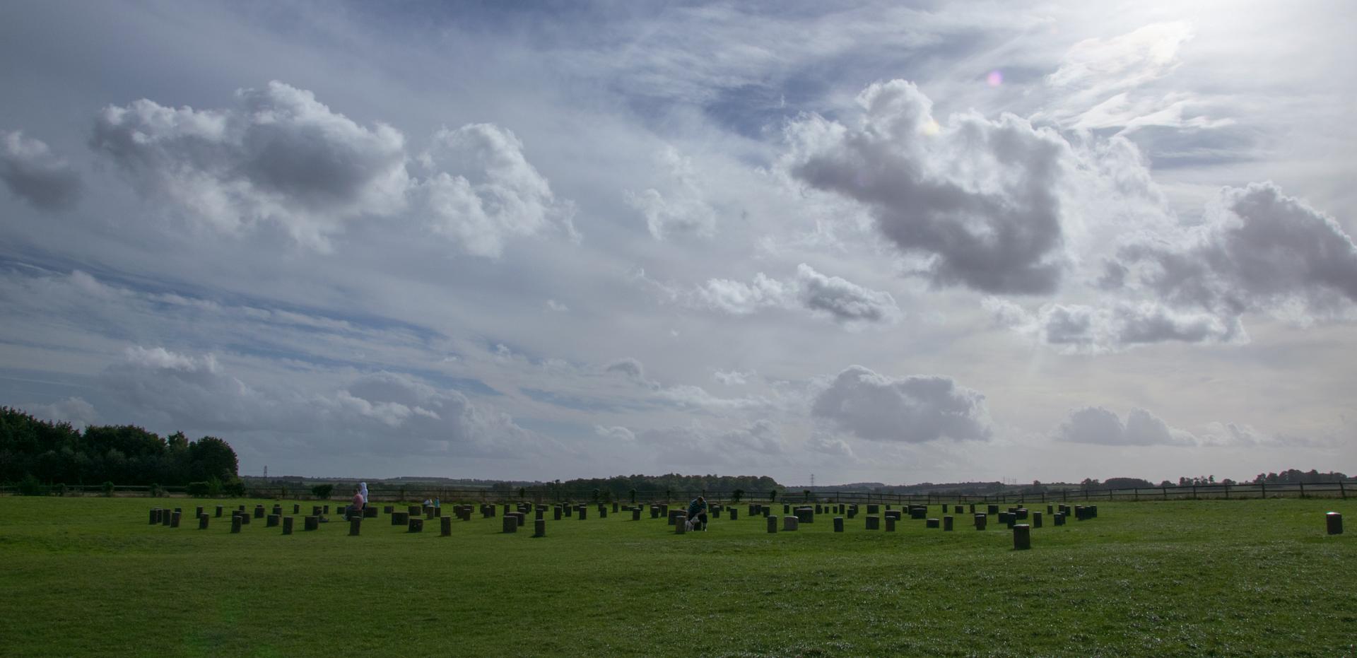
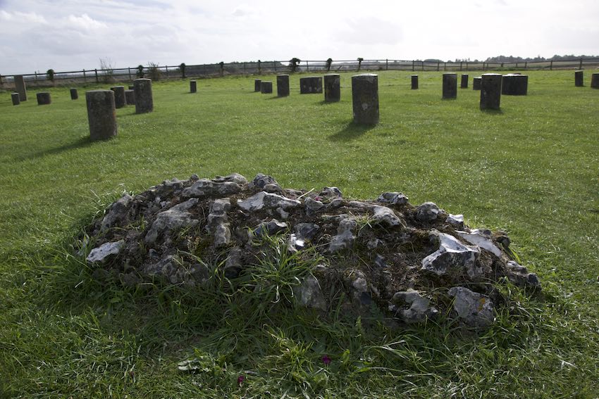
Turn left and make your way back towards the parking area. Pass through the gate, then enter the separate fenced area which is signposted as ‘Woodhenge’. Walk into the six rings of concrete posts, taking in the patterns and sizes. Notice the stone mound at the centre and the outlying stones to the north-west, which mark the entrance to the monument.
4 Woodhenge
These posts mark the site of another enigmatic monument - Woodhenge. Unlike Stonehenge it was constructed from timber posts which have since rotted away. The six concentric rings of concrete blocks mark the locations where the timber posts were discovered.
See if you can spot the largest post. The original posts were up to 6 metres high, crowded together, perhaps strung with offerings, or textiles, or carved and painted like totem poles. This would have been quite an intimidating place.
Originally Woodhenge had a henge earthwork around it (a bank and internal ditch), but later farmers ploughed it flat. If you look carefully, you may be able to spot the hint of a circular ditch in the grass around the posts.
Woodhenge is a curious monument – some archaeologists think that it was actually a building with a roof, or that the posts were joined together by horizontal timbers. It’s not clear when it was in use until – evidence suggests people carried on using the site for hundreds of years, even after the timbers started to rot away.
Finally, head towards the low stone mound at the centre of Woodhenge. This is where a three year-old child was buried. Chillingly, his or her skull had been split open with an axe – perhaps a human sacrifice performed in the sacred heart of this monument. Trying to understand the meaning of evidence like this is one of the most challenging aspects of prehistoric archaeology.
What do you think the human remains represent? Does this story make you feel differently about the site?
Woodhenge marks the end of our trail. This short route has helped us discover a site that is jam-packed with archaeological monuments that still have archaeologists scratching their heads. Recent geophysics and laser scanning research in the wider area around Stonehenge and Durrington Walls has revealed hundreds of sites that we didn’t previously know about. Some of these may be the remains of round houses and farming enclosures, but the rest of them appear to be ceremonial monuments.
We once thought Stonehenge stood in proud isolation – but the reality, just as Durrington Walls shows, is much more complicated than that. As research continues, these curious sites will undoubtedly reveal more of their secrets to us.
Directions
When you’ve finished exploring Woodhenge, head back towards the gate and the start point of the walk.
If you would like a longer walk, you can follow the footpath and bridle path marked on the map to walk to Stonehenge.
Your browser is out of date, and unsupported by this website. Please upgrade to the latest version to use this website.
A circular walk around Woodhenge in the Stonehenge World Heritage Site
Just two miles north east of Stonehenge, lies a mysterious massive monument. Unlike its more famous relation, there’s no gift shop or entrance fee. At first sight there’s not much to be seen.
But explore this place on foot and it’ll start to reveal some of its incredible secrets. Explore this ‘superhenge’ made by master builders, get hands on with the mysterious Cuckoo Stone, and discover the gruesome secrets of the enigmatic Woodhenge circle.
On this trail, writer and presenter Mary-Ann Ochota reveals the other half of the story of Stonehenge.
Follow the trail by clicking on the map pins or downloading the guides below
Park in the car park, or along the road if safe to do so. Head out of the car park and towards the gate into the field on your right. Before you leave the road, face the field and look around.
 Dave White CROPPED.jpg "Stonehenge, Wiltshire (c) Dave White")