Hello, my name’s Liz Woolley, I’m a local historian and I’ve lived in Oxford since 1985. I’m really interested in Oxford’s ‘town’ - as opposed to ‘gown’ - history, and in the working lives of ordinary citizens, especially in the nineteenth and early twentieth centuries. I’ve been investigating the city’s littleknown industrial buildings for the last few years and taking people on tours to see some of them.
On this walk you’ll discover another side of Oxford, away from the college’s ‘dreaming spires’, and visit buildings that remind you instead of the city’s little known industrial history. You’ll find out how trades like brewing, milling, clothing manufacture and bookbinding developed, and how buildings were constructed or adapted to serve these industries. You’ll also look at surviving structures from when the railway first came to the city, and also buildings related to the generation of electricity and gas.
This walk is almost circular and it’s about 2 ¾ miles long. You can shorten it by cutting out some bits if you like, or you could do sections of it on separate occasions. There are plenty of cafés along the route for when you need reviving. It’s almost all on the flat, some through the city and some along the river towpath. The towpath is well made but it can sometimes be muddy, so wear appropriate shoes or boots. I hope you enjoy the walk!
Unlike Birmingham or Manchester, not many of us would think of Oxford as ‘industrial’, in fact the Industrial Revolution more or less passed the city by. In 1850, its population was still one of small tradesmen, shopkeepers and servants, heavily dependent on the university. But when the city expanded rapidly in the late nineteenth century, the population of non-university people grew. With an increasing population there were increasing demands for gas, electricity, clean water and consumer goods such as ready-made clothes and beer. And so buildings associated with public utilities and a variety of light industries appeared throughout Oxford.
Of course industrial development is intimately linked with transport – vital for bringing raw materials in and taking finished products out. You’ll notice that many of the industrial buildings that we visit on this walk are on or near the river, the canal or the railway. And that’s why I wanted to start the walk here because this was once the terminus of the Birmingham to Oxford Canal. The canal now ends on the other side of Hythe Bridge, just to the north of here, but originally there was a wharf here. It’s still intact under the car park you’re standing in now.
The opening of the canal in 1790 was vital to the development of industry in Oxford. It provided a link with the Midlands coal fields and thus allowed the import of cheap coal. Before the canal was built, coal had to be shipped – at great expense – first by sea down the east coast from Newcastle, then through the Port of London and up the Thames.
Notice just by the north east corner of the pub, a single remaining gatepost from the entrance to the wharf. It’s built of ‘Staffordshire Blues’, a type of very hard and dense engineering brick, which you’ll see more of later on the walk.
Cross over New Road at the traffic lights and walk down Tidmarsh Lane opposite noticing the large brick building on your right. Stop at the end of this building where the road bends sharply to the right and becomes St Thomas’ Street.
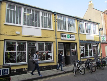
3 Cheers!
You are now in the ancient parish of St Thomas, which was one of the first areas outside the city walls to be developed – one of Oxford’s first suburbs if you like. It was also the centre of Oxford’s brewing industry. Brewing and malting were two of Oxford’s oldest industries. They were probably concentrated here because St Thomas’ was traditionally a working class district, situated outside the city wall and close to the canal wharf (to bring in supplies) and the river (a source of both power and water).
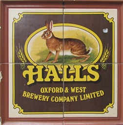
There were four main commercial breweries here – Morrell’s Lion Brewery (which you’ll see in a minute), Hall’s Swan Brewery, Weaving’s Eagle Steam Brewery and Phillips’ Tower Brewery. The four main brewing families – the Tawneys, the Halls, the Treachers and the Morrells – were all related by marriage.
In the 1870s, a national enthusiasm for beer led to the establishment of many new breweries and the expansion of existing ones. There were also lots of brewers’ agents, whose job was to arrange the import of beers from far-flung breweries into the city. By 1874 there were no fewer than nine breweries and thirteen other brewers’ agents. Brewing was a major activity both for the town and gown. Most university colleges also had their own private brew houses.
Fox’s malt house, the red brick building on the corner of Tidmarsh Lane and St Thomas’ Street, was built in the late eighteenth century and served several breweries. Notice the closely set rows of windows on the first and second floors, indicating that storeys inside were very shallow. This is typical: the process of malting doesn’t involve any machinery and so only the height in which a man could comfortably work, shovelling and turning the grain, was needed. Malting requires plenty of ventilation but little light, so these windows would originally have had wooden shutters rather than glass. A large surface area on which to spread the grain is also needed, which is why malt houses often covered a large area.
Walk on along St Thomas’ Street, being careful to keep to the pavement as traffic sweeps fast around this corner. Stop on Quaking Bridge.
4 Quaking in your boots
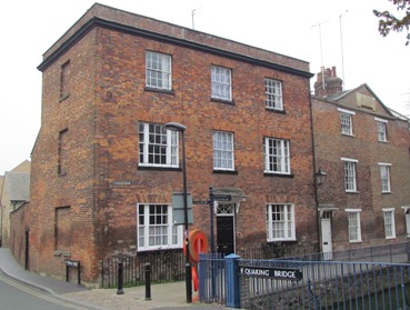
At the previous stop you heard about the city’s brewing industry. Brewing was big business and the brewers were men of wealth and influence, which you can tell from the elegant brick house at 1 Fisher Row. It was built in 1790 for Edward Tawney, who owned Fox’s malt house. Tawney also built the almshouses next door. If you look up above the third floor windows you can see a stone plaque with his name on it.
The name ‘Quaking Bridge’ was first recorded in 1297 and seems to refer simply to the rickety state of the original bridge. This current bridge was built in 1835 and was known as the ‘cockpit for the settlement of all the fights of St Thomas’ - a poor, working class area renowned for its pubs and brothels and somewhat rowdy character.
Of the notorious town-gown fights it was said ‘the great city champions came from St Thomas’, big burly bargees or reckless Irishmen.’ Indeed, Fisher Row, which was the centre of Oxford’s boating community from medieval times until the twentieth century, was described as having a ‘reputation for a sort of cheerful violence’. It was here that people who made their living as canal boatmen, river bargemen and fishermen lived.
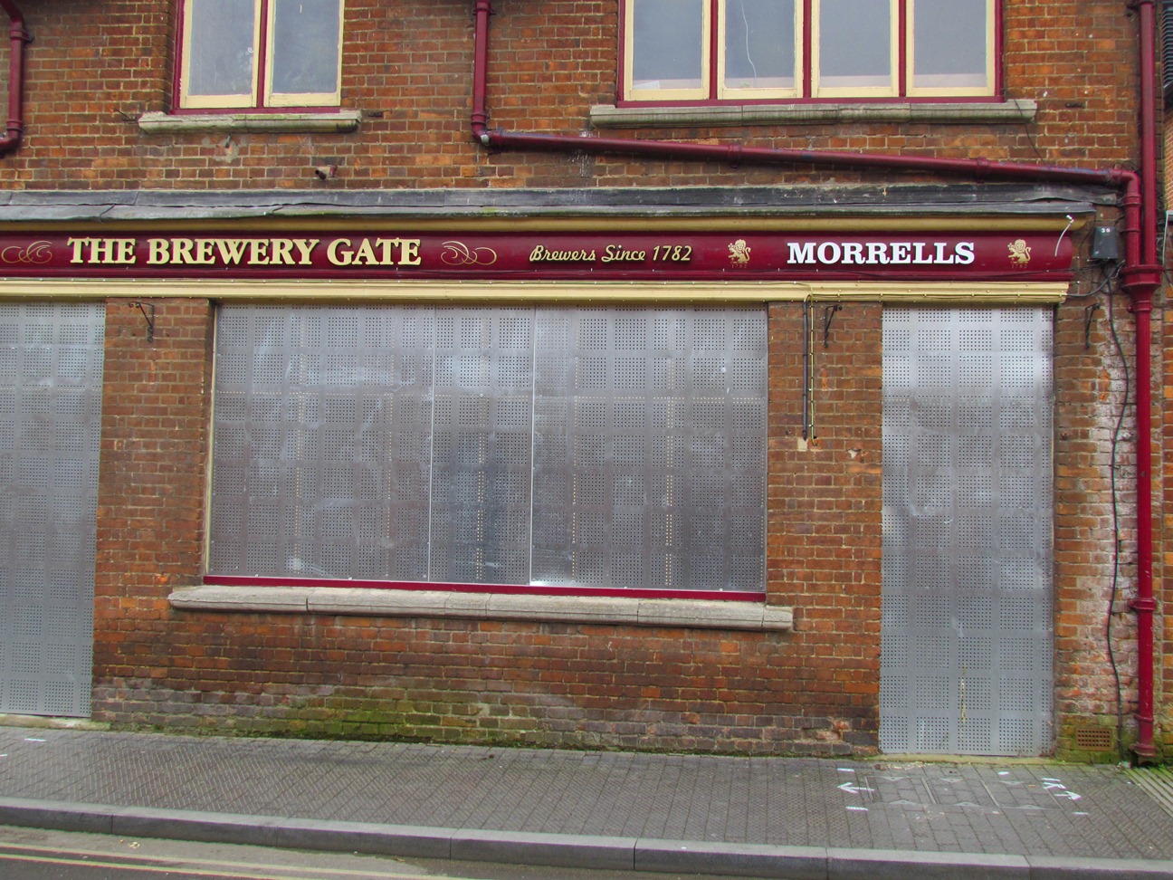
Continue along St Thomas’ Street and stop at the entrance to Bookbinder’s Court. Look across the street at the gates of the Lion Brewery.
5 A family affair
These magnificent gates would once have ushered you into the Lion Brewery. It’s since been converted into apartments. Mark and James Morrell took over this brewery in 1797 from Edward Tawney, whose house you have just seen on Fisher Row. Morrell’s continued brewing here until the late 1990s and Oxford lost one of its longest running family-owned businesses. Even before Edward Tawney’s time, this was a very old brewing site: a ‘Brewhouse and Garden’ were mentioned in a lease dating back as far as 1597.
Beyond the gates, the stone building at the centre of the courtyard was the head brewer’s office and accommodation and dates from the mid-1700s. The red brick buildings, several of whose facades have been retained in the recent housing development, were erected by Morrells’ architect, the rather inappropriately-named Mr Drinkwater, and date from the late 1800s. The building to the left of the entrance was once the brew house and to the right were the offices.
Mr Drinkwater was in popular demand at the time. Like many Oxford breweries, Morrell’s underwent extensive expansion and upgrading in response to a growing demand for beer. This was chiefly because wages had increased and the working classes had more money and more leisure time and spent much of it in the pub. To keep up with this growing demand, brewing was becoming more mechanised and more technologically advanced. To remain competitive breweries had to be increasingly efficient and organised. In turn, this meant more specialised and efficient buildings. Drinkwater himself was one of a new breed of architects who emerged in the late nineteenth century, specialising in breweries and other industrial buildings, as industrial sites went from being simply utilitarian sheds to buildings worthy of an architect’s attention.
Kindly donated by Mrs Stella van Gucci
Directions
Walk in through the gates and around the courtyard as it bends right to see how the buildings have been used and added to in the recent housing development. Emerge again onto St Thomas’ Street, turn left and left again just beyond a small car park. You’ll emerge into a short street called The Hamel. At the end of this short street turn left again following the sign Hamel Walk and go through a covered passageway. Stop to look at the tall chimney on your left.
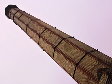
6 Up in smoke
This impressive chimney was built in 1901 by the architect Drinkwater who you heard about at the last stop. This is one of only two industrial chimneys remaining in Oxford (the other is at Frank Cooper’s marmalade factory, which you’ll see later). Once there were many chimneys – all the breweries had at least one – which contributed to Oxford’s famous skyline.
This chimney was needed when the brewery switched from waterpower to coal-fired boilers. You can still see the name of the manager, Mr Dowson, carved on this one. There’s rather a nice letter in the archives from him to the City Engineer urging swift approval of the plans for this chimney because, as he admits, ‘the work has, indeed, already started’.
Can you imagine what St Thomas’ would have been like back in the nineteenth and early twentieth centuries? The pungent aroma of fermenting hops and malt, the snorting of the cart horses, the sound of the workers’ clogs as they rushed across the cobbles. All the noise and clamour of a busy, productive brewery going about its business. It’s difficult to imagine today.
Continue on a little further through the housing development until you reach a footbridge, stop here.
7 Waterpower
This footbridge crosses the Wareham stream and on your left, next to the weir you can still see the old waterwheel which originally powered Morrell’s brewery before the switchover to coal.
The wheel itself is probably late Victorian, but we know there was a wheel on this site as far back as the eighteenth century at least. It’s a good reminder of a past age when waterpower was one of our chief sources of energy.
You’ll have noticed as you’re walking around St Thomas’ that this is a very watery place; there are lots of little streams which you keep crossing. And that’s one of the reasons why brewing was established here so long ago.
Continue ahead into a car park. Just before reaching the main road ahead turn right keeping the stream on your left. Stop on the wooden footbridge.
8 Time, gentlemen please!
You may not have realised it but you’ve just been walking on Swan’s Nest Island, an area named after the site of the Swan Brewery. You’re now standing just at the tip of it. This footbridge will take you back on to the mainland.
Like many breweries, the Swan had several different incarnations. Records show that as early as 1612 a malt house was leased on this site to a man called Thomas Holt. By 1708 his son was running a brewery here. By 1780 the brewery was in the hands of one time mayor, Sir John Treacher, and then William Hall purchased it in 1795. Hall’s prospered greatly and became a famous Oxford brand. They eventually took over all the other breweries in Oxford apart from Morrell’s.
The large stone building you can still see was a malt house, built around 1830 and the last remaining evidence that the Swan Brewery once occupied this site. The rest of the buildings were demolished in the 1960s to make way for a British Telecom building and later housing. Take a closer look at the malt house and you might notice that the building’s ground plan is a trapezium rather than a rectangle.
Walk over the footbridge back onto the ‘mainland’ and bear left along the side of the malt house. Pass through a small car park and then left onto Paradise Street. Pass the castle tower on your right and stop at the junction of Paradise Street, St Thomas’ St and Quaking Bridge.
9 Clip-clop
The single-storey redbrick building on the corner of Paradise Street and St Thomas’ Street was a horse hospital, built in 1887 by the brewery architect who we have already heard about – HGW Drinkwater.
All the local breweries used horse-drawn dray carts to carry their barrels. Drays were used to deliver beer to pubs within the city and to nearby towns and villages. A large brewers like Morrell’s, who had pubs all over Oxfordshire, would probably have used canal barges then later the railway to transport their barrels further afield.
Other local businesses, such as Archer Cowley, the removals firm (whose building you’ll see later), continued to use horse transport right up to the Second World War.
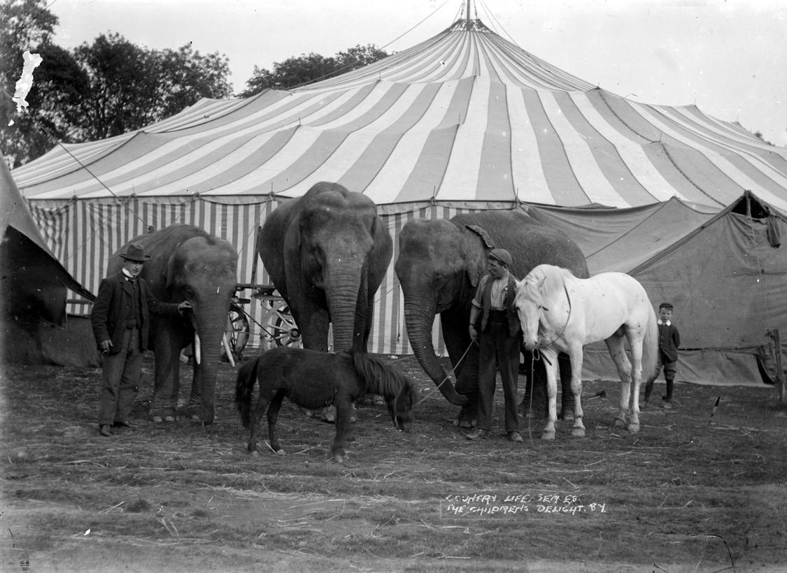
The tall chimney you can see at the end of the building served the blacksmith’s furnace. Horses came here to be shod, as well as to have minor ailments seen to. I was also told by a gentleman who grew up in St Thomas’ in the 1930s that when travelling circuses set up on nearby Oxpens Meadow, elephants were brought here to have their feet manicured!
Keeping the stream on your right continue along Fisher Row and up a flight of steps to emerge onto busy Park End Street. At a safe place cross to the other side of the street. Turn left and walk a few yards before looking across at the large red brick building opposite with ‘Cantay Depositories’ written high up on the building’s facade.
10 Pack up your bags
Across the street you can see what was once Archer Cowley & Co.’s furniture packing and storage warehouse, built in 1901. Packing, storage and shipping were growing businesses at the turn of the century. As people became more mobile, moving around the country and even abroad to take up new jobs, so new companies emerged to cater for these needs. As jobs sprang up around the British Empire in places as far flung as Egypt and India so businesses like Archer Cowley and Co. flourished.
The warehouse was built next to Oxford’s then two railway stations as lots of furniture was transported by rail. Its imposing style was no doubt intended to further the company’s reputation as prime shippers to the administrators of the British Empire.
The architect used the most up-to-date building techniques: a steel frame, with floor and stairs of reinforced concrete, and all the steelwork encased in concrete or brickwork. There were almost 4,000 square feet for storage of furniture and different sections of the building were protected by armoured fireproof doors.
Let’s now take a closer look at the building itself. It incorporated ground-floor shops with the big plate glass windows that you can still see in order to draw in potential customers, attract attention and provide an income from shop rents.
Cross the street and walk into Park End Place. At the end of the building you can see the former office and a mosaic tiled floor at the entrance.
Emerge back on to the main street. Turn left and continue along the road up to a large roundabout outside Oxford station. Cross the road leading off to the left and stop outside the elegant redbrick building on the junction of Park End Street and Hollybush Row.
11 Marmalade
This large redbrick building was Frank Cooper’s marmalade factory, built in 1902. It’s the only one of Oxford’s old industrial buildings to have listed building status.
The factory was in a prime position opposite the two railway stations. Its elaborate façade declares Frank Cooper’s confidence as a businessman. Look closely and you can see he had swags of oranges carved in the stonework above the entrance and between the first and second floor central windows. Some people say that the balls on the roofline are even oranges.
Frank Cooper had been making and selling marmalade from his shop at 84 High Street since 1874. Then around the turn of the century, two factors prompted his move to this new, purpose built and more hygienic building. Firstly, demand for his marmalade was increasing as people enjoyed more ’fancy goods’. Secondly, the Factories and Workshops Act of 1901 laid down stringent rules about the kinds of conditions in which factory-hands could work.
This new factory could accommodate 60 workers. Their dining room and restrooms, plus two storage rooms, were on the top floor. On the second floor, women cut up fruit in a long, well-lit room with large curve-headed windows. Bottling and packing (or ‘tying-down’ as it was known) took place on the floor below. Boiling the fruit took place beyond the yard on the ground floor, in a room equipped with copper vats heated through steam jackets by a boiler in the adjacent boiler-house with its large chimney.
Frank Cooper was a vigorous promoter of his products, emphasising the homemade purity and health-giving properties of his marmalade, as well as its upper class appeal. Soon after opening his new factory, he commissioned the well-known Oxford photographer, Henry Taunt, to produce a city guidebook in which page after page are devoted to Cooper’s marmalade and this wonderful new building ‘...fitted with the best modern improvements, and everything is done that is possible to obtain the highest standard of quality, purity and wholesomeness’.
He was proud to obtain royal patronage for his ‘Oxford’ brand of marmalade and the British Medical Association conference of 1936 was told that ‘The “Oxford” has played a leading part in the life of the Varsity for many years...it is even hinted - admittedly upon somewhat doubtful authority - that a certain quantity must be consumed before one can secure a degree.’
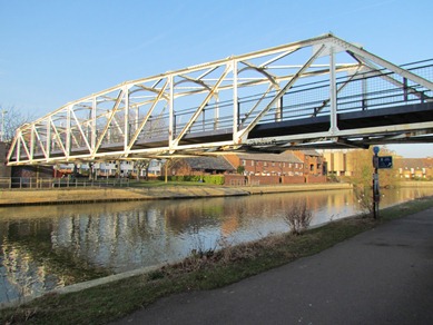
Cross the busy Friedeswide Square and with the Oxford Hotel on your right and the Said Business School on your left walk down Rewley Road. Follow the road as it bends around the back of the Business School and through a modern housing development. Stop when you reach the humped bridge over the water and look over to your left at the now defunct metal swing bridge.
12 Railway mania
You’re standing on a bridge over the Sheepwash Channel. To your left is the London, Midland and Scottish Railway (LMS) swing bridge, constructed in 1851 and designed by none other than the famous civil engineer Robert Stephenson.
The bridge was built to connect the London and North Western Railway station (which stood where the Said Business School stands now) with the train depot and local lines to Bicester and Bletchley to the north. As in all towns and cities across Britain, the arrival of the railway had a profound effect on Oxford – economically, socially and physically.
It meant that many more goods could be transported to Oxford and in turn Oxford businesses could sell goods in big cities such as London. Also, more and more people began travelling by train for both business and pleasure.
The swing bridge was built to carry the railway track across the Sheepwash Channel (a navigation connecting the River Thames with the canal). It was designed to swivel horizontally to allow boats to pass through.
Walk a little further on and turn left down a footpath until you come to a brick structure. This gives you an opportunity to look at the bridge more closely. Can you see that about half way along its length there are two posts either side of the tracks on top of which are gear wheels. There’s a horizontal bar above the wheels. Metal handles would have been attached to either end of those bars and men would crank the bridge using those gear wheels so it swivelled horizontally on its base. If you look underneath you might be able to see the big teethed gear wheel which aided this movement.
In 1853, a railway engine toppled into the water after the driver failed to realise that the bridge had been opened to allow a boat to pass. Around 1890, the swing bridge was substantially reconstructed using an early type of steel girder – probably to take heavier locomotives – and most of the surviving structure that you can see dates from this period.
Like the London and North Western station, the swing bridge closed to passenger traffic in 1951, though it remained in operation until the nearby goods yard closed in 1984. It is currently undergoing restoration by the Oxford Preservation Trust, English Heritage, its owners Network Rail, and other partners.
Continue down the footpath and under the modern railway bridge. Mind your head! Shortly after, turn left over a hump-backed footbridge (notice the horizontal wooden bars which helped horses to keep their footing as they towed barges along the river). Continue ahead along the towpath with the river on your right, and emerge onto a main road. Turn left to cross the road at the traffic lights then turn right to walk back up towards the bridge. Walk across a metal bridge on your left and down a flight of steps to the junction of North St and East St. Walk along East Street, keeping the river on your left. Stop a little further on when you see an attractive yellow and red brick building jutting out into the water.
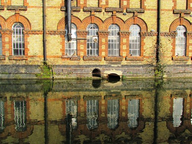
13 Let there be light
The building which you see across the river was the Electric Lighting Station, built in 1892 to generate electrical power for Oxford.
The grand opening of the works was a big event for the town. The University even set a poetry competition on the theme of ‘The Benefits of the Electric Light’. Although he didn’t win, the poet Hillaire Belloc’s entry certainly made an effort to eulogise this new form of power:
Descend, O Muse, from thy divine abode, To Osney, on the Seven Bridges Road; For under Osney’s solitary shade The bulk of the Electric Light is made Here are the works; – from hence the current flows Which (so the Company’s prospectus goes) Can furnish to Subscribers hour by hour No less than sixteen thousand candle power...
The local paper Jackson’s Oxford Journal also reported on the event: ‘Long before dusk the streets in the centre of town were thronged with crowds of persons to witness the lighting of the arc lamps.’ It was, however, after 10 o’clock before the current was turned on, and many persons left without seeing the light, which was brilliant and steady.’
The works of the Oxford Electric Company Ltd comprised this generating station at Cannon Wharf in Osney, a central switching station in Broad Street and two smaller substations at Merton Street and Carfax. The generating station here used steam-driven turbines, fuelled by coal, and pioneered an innovative system for transporting electricity across the network which became known as the ‘Oxford System’.
Initially, production was on a modest scale: it was supplied to just five street lamps and 11 businesses. But in its first year the company installed seven thousand 35-watt lamps and by 1895 almost all the colleges and some university buildings were electrified. The late nineteenth and early twentieth centuries saw exponential growth in the use of electricity in homes, places of entertainment, industry and transport and over the next ten years the generating station here was expanded five times to keep up with demand.
It’s a very attractive building. The lively facade of red and blue brickwork was perhaps intended to act as an advertisement for the exciting new industry and to distinguish it from the rather more utilitarian gasworks further downstream. In 1905, the architect Herbert Quinton, who had designed Frank Cooper’s marmalade factory that you saw a little earlier, added the small northern extension on the left hand end of the building which includes an oriole window lighting the chief engineer’s office on the first floor. I’ve been told that this was so that he could keep an eye out for his employees fishing from the adjacent wharf when they should have been at work. It’s probably more likely that it allowed him to see barges delivering the coal.
Local people had a love-hate relationship with the electricity station. They cursed the smuts which fell onto their washing, but there were compensations: water which had been used to cool the turbines was pumped back into the river warm, and people could swim and wash their hair here all year round. People also dived for pieces of coal which had fallen from barges, and which provided a welcome addition to the family grate.
Continue along the towpath keeping the river on your left. Cross the weir and stop by the lock keeper’s office on your right. Look across the water to a large red brick building on the other side.
14 The daily grind
The four storey redbrick building across the water is Osney mill. There has been a mill on this site dating back as far as the twelfth century when Osney Abbey was founded here. This was one of at least 15 mills in use in Oxford during the medieval period, mainly for grinding corn.
By the mid thirteenth century, Osney Abbey had become one of the largest and wealthiest in the country. As well as a corn mill, there was a fulling mill here (in which fullers’ earth, a sort of soil, was pounded into newly-woven cloth by hammers), and later a gig mill (to raise the nap on cloth).
There was a grist mill here in the early seventeenth century, and during the Civil War the mill was used to grind gunpowder. In 1775, part of Osney mill was being used as a china factory, and in 1829 saw mills had also been built here. The mill was rebuilt in its present form in the 1840s. Two bone mills were added at that time. By 1876, it had become a flour mill and it was enlarged in the late nineteenth century so that the mill could be driven by steam rollers.
In 1898 the mill was taken over by WH Munsey who milled flour, mainly for bread making. By 1940 the electricity station further upstream which we’ve just seen was taking so much water from the river to cool its turbines that the mill was forced to switch from waterwheel-power to electricity. This proved to be a disastrous move: in 1946 flour dust clogged the electrical circuits and the building suffered a devastating fire. Coincidentally mass-produced sliced bread was becoming more popular and the Munsey family decided not to rebuild a bread-flour mill here at Osney but instead to take over Clark’s Mill in the nearby town of Wantage, which milled flour for biscuits.
Bill Munsey still lived here at Osney in 2011, in the white Mill House to the left of the mill. The once burnt-out mill buildings were developed into flats, which are partially powered by hydroelectricity using an Archimedean screw set into the old mill race.
Continue along the towpath keeping the river on your left. Cross a bridge over a stream and pass under a railway bridge before reaching a bench from which there is a good view of the white bridge ahead.
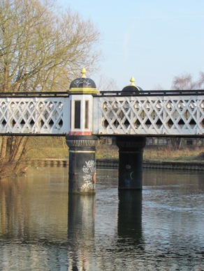
15 Auden's delight
This rather beautiful white bridge was built to bring coal to the gasworks, which once stood on either side of the river here. The Oxford and District Gas Company works, built in 1818, was Oxford’s first, large-scale, markedly ‘industrial’ building complex, but now there’s hardly any evidence that it ever existed.
Gas lighting had been introduced to the city in 1819 and later the scale of gas manufacture increased significantly as it became used for cooking, space and water heating, and for powering industrial engines. The gasworks expanded accordingly. They acquired land on the opposite bank of the river where new plant and gasholders were erected. The gasworks eventually occupied a huge area of 19 acres here at St Ebbe’s.
In 1886, a spur of the Great Western Railway was built to bring in coal from the station. Until then coal had been brought in by horse and cart causing unpopular congestion on the roads. The bridge carrying the railway across the Thames, which you now see ahead of you, was designed by the eminent civil engineer Thomas Hawksley and cost almost £4,000.
The central cast-iron piers of the bridge are sunk 20 feet into the riverbed and the end-piers are built from engineering bricks – the ‘Staffordshire Blues’, which you saw at the beginning of the walk. These are extremely dense, heavy and hence strong, and were often used in industrial buildings and structures.
The bridge had more than one use – one half was used as a cart-road, the other supported a single track of rails, and a footway allowed workers to cross between the sites on the north and south banks of the river. On the northern side, the rails were carried on an elevated wooden gantry 11 feet above the ground as far as the retort house, where coal was heated to make gas, and a turntable enabled engines to return to the station, pushing the now empty wagons back along the single track.
Imagine how very different this area was when the gasworks were functioning. It certainly is a pleasant spot now, but 60 years ago it was noisy and smelly, and not the sort of place that most people would choose for a Sunday afternoon stroll. Yet the poet W.H. Auden used to bring (perhaps surprised) visitors here because as a great admirer of T.S. Eliot’s poem The Wasteland, he thought of St Ebbe’s gasworks as the most beautiful place on earth.
Continue along the towpath and pass under the gasworks railway bridge glancing up to see the original cast-iron mains pipes still in place. Carry on until you reach another small white footbridge crossing the river.
16 Pipe dreams
This bridge was built in 1927 to carry pipes from one side of the gasworks site to the other, and was later converted into a footbridge. You might notice that the endpiers are once again made of ‘Staffordshire Blue’ bricks.
This and the railway bridge are the last physical evidence we have of the St Ebbe’s gasworks. The works closed in 1960 and, in common with many Victorian gasworks, the buildings were demolished in the late 1960s and early 1970s.
At the same time, the surrounding grid of streets lined with terraced houses, many lived in by gas workers, underwent large-scale clearance. On the opposite bank there is now a small housing estate, and what was once Gas Street has been renamed Preachers Lane as an echo of the friaries that were here in the middle Ages.
In the nineteenth century there would have been loading and unloading wharves on both sides of the river here. One notable business was Basson’s Baltic timber yard and wharf. As Oxford’s suburbs grew in the Victorian period, materials were needed to build and furnish these hundreds of new homes and so Scandinavian pine was shipped over and unloaded here.
As you cross over the bridge, see if you can find the name of the maker – the engineers Head Wrightson & Co Ltd, of Thornaby-on-Tees, written on one of the right-hand uprights.
Cross over this bridge and walk ahead through the Friar’s Wharf housing estate. When you reach a main road and a set of traffic lights cross the road and continue ahead down Old Greyfriars Street. Turn right through Pike Terrace then right again into Turn Again Lane and almost immediately left into St Ebbe’s Street. Walk up the hill and when you reach the Royal Blenheim pub turn right into Pembroke Street. Stop outside Modern Art Oxford.
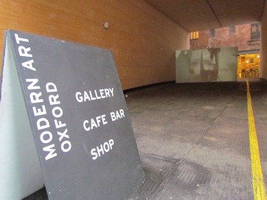
17 From ale to art
The building in front of you, which now houses Modern Art Oxford, was built in 1888 as a square room and stores for Hanley’s City Brewery. Here fermentation was carried out in ‘squares’, which were open-topped vesselsm made of stone or slate, bolted together and sealed with cement.
Hanley’s brewery was founded in the early nineteenth century and occupied a large area stretching from here to Queen Street. Four wells on site supplied the water used in the brewing process and there was a substantial brew house, offices and several other buildings around a central yard. Most were built in the later nineteenth century as the brewery, like many others, adopted new technology and expanded production to meet an ever-increasing demand for beer.
Once again, the architect of this building was HGW Drinkwater, who you encountered earlier – he built several buildings for Morrell’s Lion Brewery in St Thomas’ and carried out a number of other industrial commissions in Oxford in the late nineteenth and early twentieth centuries.
It’s free to go into Modern Art Oxford, so do have a look inside the building. You’ll see the cast iron pillars which run through all three storeys and which are marked ‘Lucy and Co’. This was Oxford’s main iron foundry which flourished in the suburb of Jericho until 2005, and features in Philip Pullman’s novel Lyra’s Oxford.
The building’s former use as a brewery has not been forgotten. On the top floor, art is now displayed in the fermentation rooms, sometimes inspired by the building’s history. In 2010 two artists-in-residence, Leora Brook and Tiffany Black, grew hops on a nearby plot and created a brand new beer!
Emerge back onto St Ebbe’s Street and continue up the hill passing on your right the large entranceway into Modern Art Oxford which led originally into the brewery yard. At the junction with Queen Street turn right, walk a few paces then look behind you at the elegant stone facade that’s now part of British Home Stores.
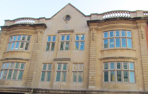
18 An elegant facade
Look up above BHS and you’ll see a rather elegant looking building. This was once the proud offices of Hall’s Brewery – one of the biggest brewers in Oxford. By the time these offices were built in 1914, Hanley’s brewery (who we heard about in the last stop) had been taken over by Hall’s which eventually took over all the other breweries in the city except Morrell’s (Hall’s itself was later subsumed into Ind Coope).
The offices here were a complex set of buildings and only part of the facade was retained when the building was converted for BHS in the 1990s. The elegant frontage, with its classical pediment and Tudor-style windows, was no doubt intended as an advertisement for the brewery’s business and as a contribution to the general ‘improvements’ that were being made to the city centre at the time.
As was common, the commercial potential of the building was maximised by incorporating three shops on the ground floor. These featured large curving plate-glass windows, which are now sadly lost.
Now look across the street at the four storey stone building opposite. It’s the tall building which features three rows of curve headed windows.
19 Ready mades
The four storey stone building that you’re looking at was Hyde’s clothing warehouse. Thomas Hyde & Co was established in 1839 and had a clothes dealership at number 32 Queen Street from at least the early 1840s. In the early nineteenth century, the middle and upper classes had their clothes hand made for them by tailors, but the working classes had to make their own. As wages grew in real terms, ready-made clothes became increasingly popular, as well as affordable for workers. A business like Hyde’s boomed.
This striking warehouse on the main commercial street in Oxford was erected in 1877 at a cost of £8,500. It has a facade of Bath stone, which served to advertise the company’s products and its growing commercial success.
It looks rather like an Italian palazzo, doesn’t it? In fact, many contemporary warehouses and factories were being built in a similar style. Italianate architecture was strongly associated with commerce and with the ideals of free trade, in contrast to the Gothic style which dominated architectural fashions at the time.
The building was designed by architect Frederick Codd, better known for his elegant villas in North Oxford, and was built by Symm & Co, who were founded in 1797. Until the 1960s Hyde’s warehouse had a balcony at first floor level and another on the third floor, reached by glazed doors at either end of the rows of windows.
Notice an advertisement for one of Hyde’s rivals, Frank East, high up on the side wall of the adjacent building to the left. Frank East owned a drapery store at nearby Carfax.
Cross over busy Queen Street, turn left then take the first street on your right (New Inn Hall Street) keeping Bonn Square on your left. Shortly afterwards turn right into Shoe Lane, then right again into a dead end just before the entrance to the shopping centre. Look over at the brick building to the right.
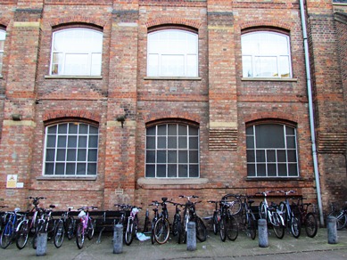
20 Piecework
Staying with Hyde’s and their clothing businesses, the redbrick building on your right with the large windows is another of their sites. This functional factory is in stark contrast to the elegant warehouse that you saw a minute ago on Queen Street. It was designed by architect Frederick Codd in 1869, very much with function in mind.
Victorian industrial development brought more diverse and complex manufacturing processes, and the machines that powered them needed to operate in an efficient, cost - effective and safe manner.
So here, the basement contained rooms for an engine boiler, warehouse and sorting rooms; on the ground floor was a steam-driven cutting room; over this was a stock room; and above, two storeys for sewing machines.
Hyde’s and Lucas’ (another clothing firm whose building you’ll see shortly) were the biggest employers in Oxford at the time, (other than the university). Between them they had several hundred workers, mainly women, some of whom worked in these factories but many of whom sewed and finished garments at home. The hours were long and the wages were very low. On average they were paid 3d a pair for finishing trousers and for that they had to collect and deliver the garments from and to the factory as well as buying their own thread.
A report in the local paper Jackson’s Oxford Journal of January 1868 gives a sobering insight into their everyday lives of these women. A woman outworker almost drowned walking from Eynsham to Oxford, eight miles away, to deliver finished clothes to Hyde’s, ‘... carrying a child in her arms and a great weight of ready-made clothes on her back, she fell into a ditch six feet deep opposite the end of Binsey Lane in the dark’.
Return back along Shoe Lane and turn right onto the main street. Walk downhill until you come to St Michael’s Street on your right. Turn into St Michael’s Street and stop to look at the long, low building across from you. It’s the third from the end.
21 A binding trade
No. 28-32 St Michael’s Street was, until 2010, the premises of Maltby’s, the bookbinders. Notice the size and number of windows on the first floor. This was the workshop where the books were bound – the binders needed a lot of light for their close work.
Thanks to the presence of the university, Oxford supported a huge number of bookbinders, far more than any other town of similar size, except perhaps Cambridge.
The bookbinding trade, and others of interest to the university like printing and bookselling, were controlled via a system of ‘privileged persons’, which meant that to enter those trades one had to actually become a member of the university.
This system ran in parallel with that of the city’s freemen, in which certain trades could only be practiced if you were a ‘freeman’ of the city and a member of a guild. The Municipal Corporations Act of 1835 swept away these trade restrictions and allowed anyone to set up in business.
Retrace your steps back along St Michael’s Street then turn right back into New Inn Hall Street. Follow the street down until you reach George Lane then turn left. Walk down George Lane until you come to a small lane on the left next to a pub. This is Bulwarks Lane. Look at the red brick building on the right of the street.
22 Manufacturing Oxford
This three story redbrick building was the former factory of WF Lucas, manufacturers and ladies’ outfitters, designed in 1890 by the ubiquitous Harry Drinkwater. The building is functional in style and could accommodate 300 workers. It had a basement dining room, internal lavatories and lifts to all floors. It was designed to ‘...contain every modern requirement for the comfort of the employees’.
At the time, the importance of healthy and safe conditions for workers was being recognised. This included ventilation, light and freedom from dirt and dust in working spaces, as well as restrooms, canteens and social facilities.
Newspaper reports of new buildings like this one frequently mention their compliance with relevant new legislation. Though manufacturing was no doubt hard work, these new laws improved the working life for many thousands of people.
This is the end of our walk. I hope that you’ve enjoyed looking at some of Oxford’s old industrial sites, structures and buildings and that you feel you’ve found out something new about the city’s working past.
By no means all of Oxford’s industries were explored in this walk - brass and iron founding, brick making, quarrying, boat-building, steam engine building, printing and paper-making also flourished in the city, but sadly buildings and structures associated with those industries are almost all now gone.
The seeds of Oxford’s most famous industry - car-making - were sown in 1912 when William Morris assembled the first Bullnose Morris at his garage on Longwall Street. After the First World War car manufacture developed rapidly at Cowley, turning Oxford, at last, into a major industrial centre.
This is the end of the walk. If you want to return to the starting point, continue along George Street and at the junction with Worcester Street you will see the car park and The Duke’s Cut pub ahead of you and to the left.
Your browser is out of date, and unsupported by this website. Please upgrade to the latest version to use this website.
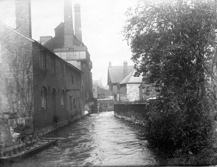
St Ebbe Gasworks (thanks to Professor Richard Wayne, the University of Oxford)
Oxford industry walk
An industrial walk in the heart of Oxford
Not many of us think of Oxford as an industrial city. It’s not known for its coal mines, shipyards or textile mills. At the height of the Industrial Revolution in 1850, Oxford was mainly a place of small trades linked to the university.
But as Britain changed from a rural society to an urban one and farm workers flocked to the towns in search of work, places like Oxford expanded rapidly.
This walk tells the story of how Oxford became industrialised, where manufacturing and light industries grew at a pace, bringing Oxford into the modern age.
Explore the lesser known parts of this much visited city and open your eyes to Oxford’s industrial past.
Follow the walk by clicking on the map pins or downloading the guides below
.jpg)