For centuries the ancient town of Dover on the Kent coast has been the literal and symbolic gateway between Britain and Europe. As a result Dover has been called the ‘Lock and Key of England’, welcoming travellers and battling invaders throughout British history.
Dover’s history is entwined with the defence and protection of Britain. At just 21 miles from France, its location that has made it an important trade and tourism site with one of the busiest ports in the world. The town, and especially its sea views, have also inspired generations of artists, writers and musicians. The short Channel crossing has seen a variety of record attempts.
This walk looks outward from Dover to explore the town’s various international connections. From people who tried to invade the town to those who helped to defend it. We will see an ancient castle, a lost river and the famous White Cliffs. Discover how people from overseas including a Hungarian saint, an Italian inventor and a French aviator helped to shape the town.
To begin the walk make your way to Dover Town Hall on Biggin Street. For the best view use the pedestrian crossing by the letterbox to cross the road. Stop when you can see a bell on the side of the building
2 Ringing the changes
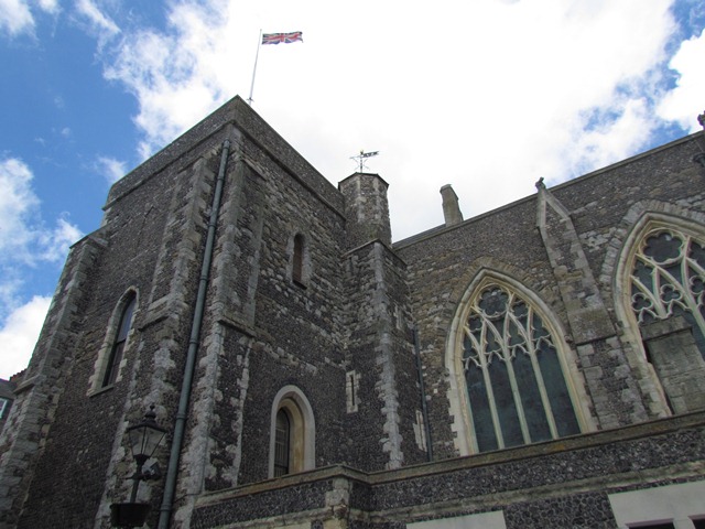
We begin exploring this historic port with an ancient building, the Maison Dieu. It was founded by Hubert de Burgh, the Constable of Dover Castle, and the oldest parts date from 1203. Since 1834 it has served as the Town Hall.
The name ‘Maison Dieu’ is the Norman French for ‘House of God’. This reflects how the building was originally a hostel for European pilgrims, who would stop here on pilgrimages to the shrine of Thomas Becket in Canterbury.
A chapel was in 1227 and King Henry III is thought to have attended a service. When Henry VIII founded the Church of England in the 1530s the Maison Dieu was given to him and it became a military hospital and supply base.
The building’s military connections are still visible from the street. Look up for a bell set in the wall. This is the Zeebrugge Bell which was presented to Dover in 1918 by the King of Belgium. It's a token of gratitude to Dover soldiers who carried out a daring raid to liberate the Belgian port of Zeebrugge during the First World War.
In just one stop we have already seen how Dover has been shaped by international travel and conflict. We will see many other examples throughout the walk.
Cross the road at the traffic lights and turn right. Stop past the Maison Dieu outside the war memorial on the square of grass.
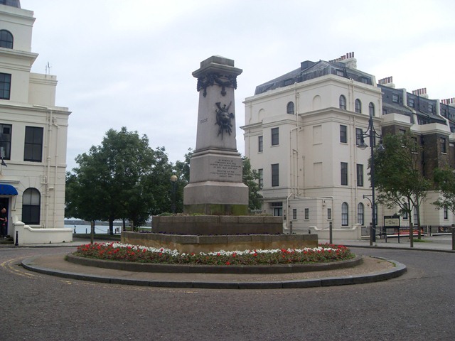
3 Conflict and co-operation
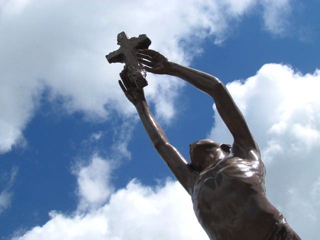
This is the Dover War Memorial built to commemorate the victims of the First World War. The sculptor, Richard Guldon, had fought in the trenches in France during 1914 and 1915. His sculpture depicts the figure of 'Youth' grasping a flaming cross.
Behind the memorial is Maison Dieu House which dates from 1665. Today it is the home of Dover Council. As the civic authority of Dover, the council are responsible for maintaining the memorial.
The council also runs Dover’s town twinning agreements. Dover is twinned with Huber Heights in Ohio, USA and Split in Croatia. Since 1973 Dover has also been twinned with Calais in northern France.
Dover has especially strong ties with France. Dover beach is only 21 miles from the French coast, making it the nearest point in Britain to France. Dover is also one of the few British towns with a corresponding French name, ‘Douvres’. Throughout Britain’s history, France has been both an ally and an enemy and Dover has often been on the frontline of both conflict and co-operation.
Pass the war memorial and continue along Biggin Street. Cross over Pencester Road and continue on to Cannon Street. Walk down the left hand side and look above the shop fronts of the buildings opposite. Can you spot a figure of the Greek god Mercury? Also look out for a bear further down the street! Stop when you reach St Mary the Virgin Church.
4 Windows on the world
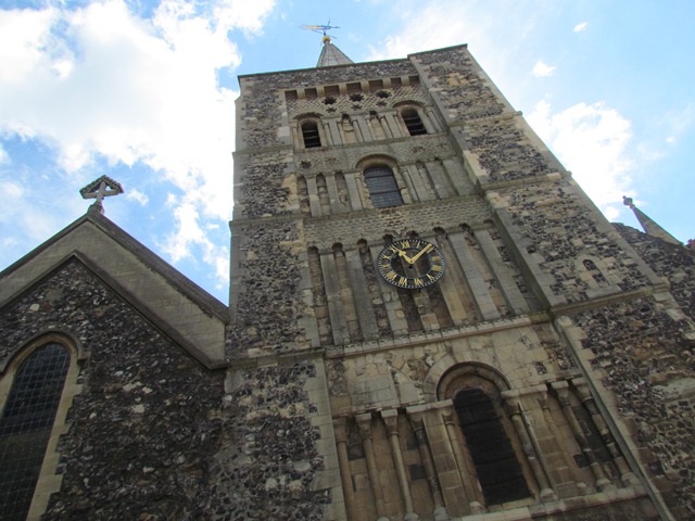
This is the Church of St Mary the Virgin. There has been a church on this site for centuries. It is thought a Roman church once stood on this site though the oldest parts of this building date from the Norman invasion.
Do go inside if the church is open. Look out for an impressive Dutch wall painting of the Nativity and a stone plaque from the Protestant Churches of the Netherlands. Another notable feature is the stained glass windows. The Air Sea Rescue Window is dedicated to the marine sections of the RAF who served in the Second World War. There is also a memorial window to the victims of the Herald of Free Enterprise disaster, which occurred when a ferry capsized at Zeebrugge in 1987.
Many of the windows are replacements as the originals were destroyed when Dover was bombed during the Second World War. Dover sustained heavy damage during German attempts to invade Britain. The effects are still visible today in the town's high proportion of modern buildings.
When you are ready, leave the church and return to Cannon Street. Facing the tower, take the path to the left of the church. Turn right at the end and stop on the path before the car park. Look at Dover Castle on the hill.
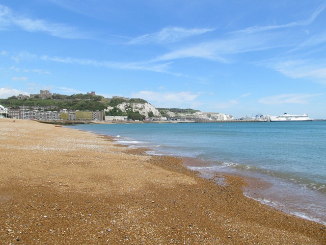
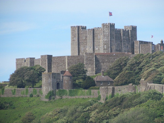
5 Under lock and key
Towering above us is the largest castle in Britain. Dover Castle has been described as ‘the Key to England’ for the major role it has played in Britain’s history. For over 2,000 years it has seen off waves of invaders and protected countless people.
This view shows the Castle's excellent defensive site, ideal for spotting trouble from land or sea. The Saxons and the Romans first took advantage of this natural clifftop location and a castle was long established before William I arrived in Britain in 1066. In fact William travelled to London via Dover especially to capture the castle.
Much of the building we can see was built 200 years later in the twelfth century. Dover became the first concentric fortress in Western Europe with two lines of defence walls.
In the 1800s during the Napoleonic Wars with France, Dover was braced for invasion. So a network of secret tunnels was built in the cliff under the castle. These were used as a barracks for soldiers drafted to the coast. At the height of the wars the tunnels housed over 2,000 men.
In the Second World War these tunnels were converted into a military command centre and hospital. In May 1940 the evacuation of allied soldiers from Dunkirk was masterminded from these same tunnels.
Turn left and follow the path into the parkland. Make your way towards the bandstand. In front of the bandstand, look for a trail of flagstones with dates on them. Stop when you have found the trail.
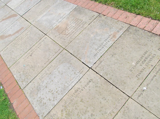
6 A walk through time
We are now in Pencester Gardens where we can take a relaxing stroll through Dover’s history. This set of flagstones inscribed with dates is the Timeline Pathway.
Each stone lists significant events in Dover’s development. The suggestions came from the town's residents. To follow the trail, start with the first stone on the left and continue clockwise around the bandstand. The first event listed is the building of two Roman lighthouses in 120 AD. One of them still survives: the Pharos in the grounds of Dover Castle.
As you continue there are plenty more events to spot. One of the earliest is the arrival of the Black Death (the Plague), which reached Dover in 1348. The Black Death originated in China and was spread through Europe on trade routes. The disease probably came into Dover on a ship with infected rats.
When you have finished following the trail pass the bandstand and cross the park to the line of trees behind. When you reach the path turn right and follow the stream. Stop part way along it.
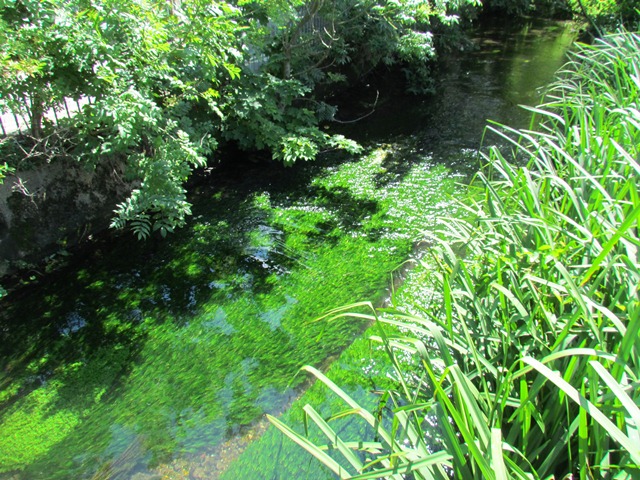
7 The waters
Though it seems unlikely today, this stream was once a large river. This is the River Dour which starts in the village of Kearsney four kilometres to the north then runs through Dover and out into the English Channel.
Over 3,500 years ago, Bronze Age settlers lived by the Dour. Up to the Victorian era people used the river domestically and to power various industries including mills, an iron foundry and a tannery.
The river really flourished under the Romans. After the Roman invasion of Britain in 43 AD the Dour estuary was developed into Dover’s cross-channel port. The Roman name for Dover was Dubris or ‘the Waters’.
In around 85 AD Dover became the home port of the Classis Britannica or ‘the British fleet’. The Classis Britannica protected Roman trade routes between Britain and France and provided supplies for the Roman forces based in Britain. The River Dour would have been lined on both banks with their ships.
In about 130 AD the Classis Britannica built a large fort near where the Dover Discovery Centre is today. A later Saxon Shore fort (built around 270 AD) can be seen behind the centre. Another Roman structure is the Painted House near the Market Square. It dates from around 200 AD, and like the Maison Dieu, was a hotel for travellers.
The Painted House contains the best preserved Roman plaster on any site north of the Alps. The designs feature Bacchus, the Roman God of wine and revelry. They would have made a comforting backdrop for weary visitors.
At the end of the riverside path cross the small bridge and turn left into Dieu Stone Lane. Pass the car park and cross over at the traffic lights. Take note of the patch of grass behind a fence on the left then turn into Ashen Tree Lane. At the end use the traffic lights to the right to cross Castle Street. Turn left and continue uphill a short way then take the first right towards The White Horse pub. Stop at the ruin next to the pub.
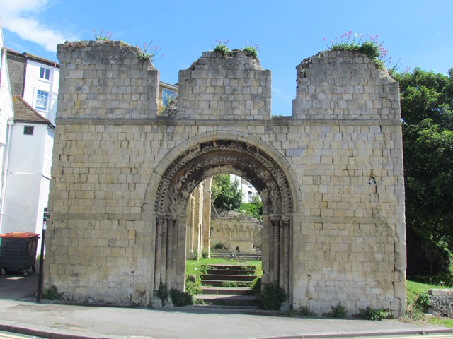
8 A tidy ruin
These haunting ruins are the remains of St James Church. This twelfth century church was particularly important to Dover as it was the meeting place for the Barons of the Cinque Ports.
The Cinque Ports were five ports on Britain’s south coast – Hastings, Romney, Hythe, Sandwich and Dover. These ports had special royal privileges, such as tax exemptions and their own law courts. In return the ports were expected to provide men and ships during wartime. You can still see the Cinque Ports emblem – three ships on a red and blue shield – throughout Dover.
The Cinque Ports were founded around 1050 by Edward the Confessor, one of Britain’s last Saxon kings. By the thirteenth century the original five ports struggled to fulfil their defensive role so others were allowed to join. The Cinque Ports Barons held several councils here at St James Church.
By the 1850s St James Church was considered too small and run down for the Barons, so a New St James Church was built. The last council was held here in 1851 and led by the Duke of Wellington.
The church was destroyed by bombs during the Second World War. The romantic remains were left as a memorial to Dover’s suffering during the conflict. The site is often called ‘the Tidy Ruin’.
Ironically Old St James has lasted longer than its successor. Do you remember the patch of grass before Ashen Tree Lane? New St James Church stood there. It survived the war intact but it was demolished afterwards as the parish declined.
Leave the church and walk ahead past the Leisure Centre. Continue down Woolcomber Street. Use the double traffic lights to cross over the main road. Turn left then take the path by the car park at Marine Court. Cross the seafront road, taking care for traffic and the cycle path. Stop by the railings.
9 Eastern promise
Ahead are the Dover Straits, the narrowest part of the English Channel. On a clear day you can see the French coast on the horizon.
The views along the Straits, edged by the White Cliffs, have inspired many artists, writers and musicians. One of the most famous is Matthew Arnold’s 1851 poem, ‘Dover Beach’. It opens with a description of the view towards France:
The sea is calm to-night. The tide is full, the moon lies fair Upon the straits; —on the French coast the light Gleams and is gone; the cliffs of England stand, Glimmering and vast, out in the tranquil bay.
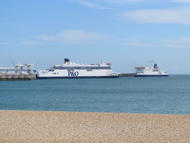
Dover’s coastline is also home to a major working port. To the left are the Eastern Docks. Goods from around the world, from fresh fruit to new cars, iPods to antiques are imported through Dover on trucks and shipping containers. The Dover Straits are one of the busiest shipping lanes in the world used by over 400 commercial vessels a day.
It's also an important tourist route. Each year over 13 million people cross the Channel here. You should be able to spot some of the car ferries. Car ferry services grew here from the 1950s, when car ownership and overseas travel both became more affordable.
Cross back over the seafront road. With the sea on your left follow the path beside the gardens. Stop at the statue of Captain Matthew Webb.
10 Webbed feat
This statue celebrates Captain Matthew Webb, the first person to swim across the Channel unaided. On 25 August 1875 he dived into the water from Admiralty Pier beyond the promenade. Covered in porpoise oil to keep him warm he landed at Calais 21 hours and 45 minutes later.
The first woman to swim the Channel was Gertrude Ederle. Dubbed the ‘queen of the waves’, she achieved the crossing in 1926.
Webb and the other early cross-Channel swimmers helped to popularise swimming as a pastime. Before the Victorian era relatively few people in Britain could swim. Those who could usually swam competitively rather than for leisure.
In recent years people have swum the Channel to raise money for a variety of charities and causes. Look out for a sculpture of swimmers further along the seafront.
Since Captain Webb’s swim people have also used a variety of other human-powered methods to cross the Channel, including rowing, sailing, kite surfing, water skiing and skydiving.
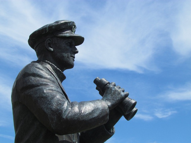
Continue along the seafront. Stop beside the statue of a sea captain looking out to the water.
11 Battling for survival
As we heard at the last stop, crossing the Channel has long been a sport or pastime. But the Channel has also been used less peacefully.
The Dover Straits have carried many warring armies to and from Britain. Julius Caesar first brought Roman forces to Dover by boat in 55 BC while the Spanish Armada escaped through the Straits in 1588.
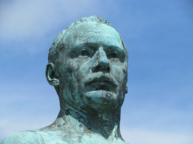
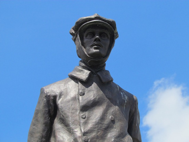
This memorial is a tribute to the Merchant Navy forces that helped to protect Britain during the Second World War. As an island, Britain relied on supplies shipped from abroad. For Britain to survive the war, it was essential to keep sea supply lines open. So Merchant Navy ships continued to import goods into Dover despite constant attacks from enemy submarines and aircraft.
The ships, their crews and the forces that protected them across the seas came from many Allied countries. The Norwegian Navy for example were based in Dover while their homeland was under German occupation.
Dover was also where the famous Dunkirk evacuation started from. In 1940 France fell to Nazi Germany. Allied troops were forced to retreat through Europe to Dunkirk on the French coast. A fleet of 850 vessels set off from Dover to rescue them.
The fleet included many civilian craft such as fishing boats, lifeboats and pleasure cruisers. The bravery of their crews meant almost 340,000 British, French and Belgian soldiers were rescued. The phrase ‘Dunkirk spirit’ is still used today to describe resilience and unity against the odds.
Continue a short distance along the seafront. Stop at the statue of Charles Stewart Rolls.
12 Fast flights
This is a statue of Charles Rolls, co-founder of Rolls-Royce. A motoring enthusiast from an early age, Charles travelled to Paris aged 18 to buy his first car and joined the Automobile Club of France. He met Frederick Henry Royce in 1904 and they launched their first Rolls-Royce car later that year.
Rolls was also a pioneer aviator. In June 1910 he became the first man to make a double crossing of the Channel by aeroplane. For his non-stop flight from Dover to Calais and back he was awarded the Royal Aero Club Gold Medal. Sadly Rolls was killed only a month later during an air display at Bournemouth.
The first Channel air crossing was in 1785 when Jean Pierre Blanchard and John Jeffries travelled from Dover to Calais by balloon. The first cross-Channel plane flight was completed in 1909 by Frenchman Louis Bleriot. After a 37-minute journey he landed behind Dover Castle, guided by a friend waving a large French flag. A memorial marks the exact spot. It was paid for by Bleriot’s friend, Alexander Duckham, who founded Duckhams Motor Oil.
The Dover–Calais route is still popular for air travel records in vehicles including helicopters, microlites and gliders. In September 2008 aviator Yves Rossy took under 10 minutes to cross the Channel by jet pack!
Continue along the seafront then turn right into Wellesley Road. Pass the ferry mosaic on the corner and follow the road left into Camden Crescent. Stop at a safe place across from the war memorial in the middle of the traffic island.
13 A sign of the time
The tall obelisk in the middle of the road is another war memorial. It records the Indian Rebellion, also known as the Indian Mutiny or India’s First War of Independence. The conflict took place between 1857 and 1859 when India was a British colony.
India was the ‘jewel in the crown’ of the British Empire and produced many valuable commodities including dye, silk, cotton, tea and opium. Most of this trade was organised by the British East India Company. The Company was very powerful with military and legal powers.
A group of private Indian soldiers protested at the Company’s trade monopoly. Their protest gathered momentum and became a wider attack against British rule in India. Battles and sieges took place in major cities including Delhi, Lucknow and Kanpur.
This memorial was unveiled in August 1861 to some of the British soldiers killed in the conflict. Notably, none of the Indian dead are listed or even acknowledged. The memorial is a sign of the time it was made. Bombastic and triumphant, it highlights some of the attitudes to the colonies during the era of Empire.
As we will see, later conflicts would result in more nuanced reflection.
With the memorial on your left, head through New Bridge towards the sea. Turn right and continue along the seafront path. Stop when you reach a rectangular panel on the seafront with an eagle and German writing on.
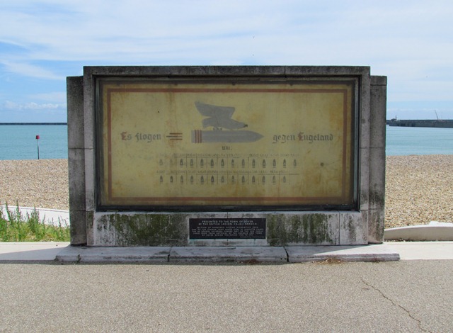
14 The Frontline
As we have heard Dover is only 21 miles from the Continent and the town has seen off many potential invaders from across the Channel. This large piece of metal is a stark and chilling reminder of probably Dover’s toughest test.
With France under German occupation during the Second World War, Britain became a target for Nazi invasion and Dover bore the brunt of Hitler’s campaign to invade.
This is a piece of armour plating from a Nazi long-distance gun. It shows an eagle riding a bullet with the words ‘Es flogen gegen Engeland’ or ‘It flew against England’. Underneath is a tally of shells that the gun fired.
Calais’s cliffs were lined with these German guns which were designed to fire ammunition across the Channel to reach England. From July 1940 to September 1944 over 2,200 shells landed in Dover. Over 460 bombs were dropped and there were over 3,000 air raids. 216 people were killed, 344 seriously injured and over 10,000 buildings were damaged.
The long-distance guns were captured in 1944 and this armour plate was presented to the people of Dover as a tribute to the onslaught the town had faced. The ‘Frontline Britain’ stone memorial opposite marks the 50th anniversary of the guns’ capture and pays tribute to the people of East Kent.
Continue along the seafront path taking time to pause at the Dunkirk Veterans Association memorial. Pass the shelter with a spike on the roof then stop by a white stone plaque in the ground. Look across the road at the building with the large coat of arms above the door.
15 Street stories
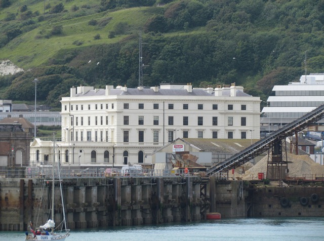
This elegant building is the office of the Dover Harbour Board who run and maintain Dover Port. The building is part of a terrace built in Georgian style.
The Georgian period is named after Britain’s four kings named George who ruled from 1714 to 1830. Georgian architecture is known for well-proportioned symmetrical designs. The style became very fashionable throughout the British Empire, particularly in the United States, Canada and Jamaica.
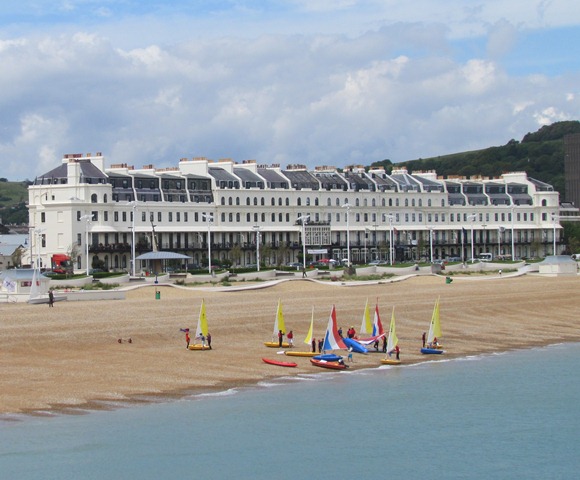
Though Dover’s seafront road looks like one continuous street it is actually divided into four sections. Beyond the Eastern Dock is East Cliff and you have already made your way along Marine Parade. This stretch is Waterloo Crescent, named after the Battle of Waterloo fought between England and France. The section beyond is known as the Esplanade.
If you look back along the seafront you can see the difference between the pre-war and post-war buildings. While the ornate terraces date from the 1830s, the brown terraces you passed earlier are a complex of flats called The Gateway. They were built after the Second World War when much of Dover needed rebuilding after heavy bombing.
Follow the seafront up to a roundabout just before the pier. Stop beside a small porch with a memorial stone to King Charles II.
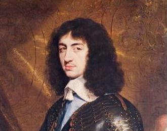
16 Order restored
Although Dover has faced conflict many times, the town has also seen conflicts resolved. This stone records Kings Charles II’s return to England from exile.
During the 1640s and 1650s England went through a bloody Civil War. King Charles I and Parliament disagreed on various political and religious issues. Charles was also unpopular for marrying a Catholic, Henrietta Maria of France, when Britain was a Protestant nation.
Events culminated in 1649 when Charles I was executed. For over a decade England was ruled by a commonwealth rather than a monarchy. The dead king’s son, Charles II, fled to Europe.
Support for the commonwealth faded after its leader, Oliver Cromwell, died. Parliament invited Charles II back to England to resume the throne. On 25 May 1660 he arrived on Dover beach from the Netherlands, met by cheering crowds and a gun salute from the Castle.
Charles II is not the only statesman to come home to Dover. In 1415 King Henry V landed here after the Battle of Agincourt in France. Four hundred years later the Duke of Wellington came ashore here after another French campaign, the Battle of Waterloo.
With your back to the monument turn left then follow the path on the far side of the railings. Pass the clock tower on your right and go onto the pier. Continue along the pier until you find a stone marker on the left with the Prince of Wales written on it.
17 Sea sailings
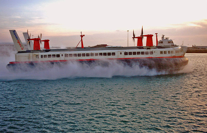
We are now on Prince of Wales Pier, named after King Edward VII. It was built as a terminal for cargo ships and liners. Later cross-Channel catamaran and hovercraft services ran from here. The first commercial hovercraft was tested between Dover and Calais from 25 July 1959, the 50th anniversary of Bleriot’s flight.
Catamarans and hovercraft no longer run from Dover (but you can see the landing stages through the portholes of the pier shelters). Some ferry routes have also discontinued. In recent years Dover’s sea crossings have been affected by the Eurostar, the railway that runs from London via the Channel Tunnel.
On the other hand, some sea crossings are thriving. Parallel to the pier is a cruise terminal at the Western Dock that welcomes vast liners from around the world. In the last decade Dover has become Britain’s second-busiest cruise port with over 300,000 passengers each year.
People have been crossing the Channel by sea from Dover for centuries. A Bronze Age boat discovered in Dover was carbon dated at 3,550 years old. Propelled by 18 paddlers, experts believe the boat would have carried cargo and passengers across the Channel.
Continue along Prince of Wales Pier. Take your time to enjoy the views on both sides. Stop when you reach another stone marker, this time on the right hand side. This is the Clifford Jarrett memorial compass. Use the compass to find Shakespeare Cliff.
18 Words by the water
Looking back towards the land on the left you should spot the distinctive Shakespeare Cliff on the horizon. William Shakespeare is thought to have visited Dover in 1605.
The cliff got its name from lines in King Lear when the Earl of Gloucester accurately describes the cliff shape:
There is a cliff whose high and bending head Looks fearfully in the confined deep
Shakespeare was one of many writers inspired by Dover. Charles Dickens lived here briefly and set some of his novel David Copperfield in the town.
Dickens stayed at the Lord Warden Hotel, the square building to the right of Shakespeare Cliff. There he wrote parts of A Tale of Two Cities. The hotel's other wealthy guests included fellow novelist William Thackeray, and Emperor Napoleon III of France.
A more recent writer inspired by Dover is Daljit Nagra. His debut collection of poems, ‘Look We Have Coming to Dover!’, was published in 2007. His poems about British-Indian culture are often written in a mix of English and Punjabi.
Continue along Prince of Wales Pier. When you reach the gates at the café, turn around and look back at the White Cliffs.
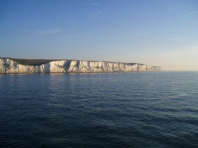
19 A symbol of Britain
Ahead are the White Cliffs, one of the defining landmarks of Britain. They highlight Britain’s status as an island and have great symbolic value. The cliffs form an obstacle and a welcome, instil pride and fear, and have inspired generations of people.
The cliffs are about 136 million years old and reach up to 350 feet (110 metres) high. They get their distinctive colour as they are made of chalk highlighted by black flint.
There are white chalk cliffs like Dover’s on the Danish islands of Møn and Langeland and the island of Rügen in Germany. These islands used to be part of the same rock formation as the White Cliffs along the south coast of England. They separated over millions of years due to sea currents and movements under the Earth’s surface.
Chalk is a soft rock. This makes it easy to tunnel through, to hide soldiers or run trains for instance. However chalk is also prone to erosion. Over the years many sections of the White Cliffs have fallen into the sea. See if you can spot brighter strips on the cliff face.
You might just be able to make out a white building on the cliff top. This is the South Foreland Lighthouse where in 1899 inventor, Guglielmo Marconi, received the first international radio transmission from France.
The White Cliffs are perhaps most famous for the wartime song ‘(There’ll be Bluebirds Over) the White Cliffs of Dover’. Vera Lynn recorded it in 1942 and it became very popular in Britain and beyond. Known as The Forces’ Sweetheart, Vera Lynn performed it for Allied troops around the world.
The song was written by American composers who had never been to Britain - which might explain the bluebirds, a species native to the United States!
Remain at the pier and look at the view of the cliffs.
20 The key to the Kingdom
This view of the White Cliffs is a fitting place to end our walk. From here we can see one of the defining views of Britain. This is a sight that people have taken in for thousands of years: soldiers and sailors, artists and writers, tourists and travellers, migrants and monarchs.
From here we can also see Dover’s history etched into the chalk; the castle towering over the coast built to protect Britain from invaders, the town nestled between two cliffs along the River Dour, and the seafront buildings that bear the scars of war.
We can also see the docks that have processed goods from around the world and the ferry terminal that welcomes travellers.
We can also look back symbolically at Dover and see many of the aspects that make Britain so diverse. From geographical features to built landmarks, signs, inventions and discoveries, trade links and cultural references, Dover is indelibly connected to the world and remains the ‘lock and key’ to the United Kingdom.
To return to Dover Priory station; retrace your way back to the Indian War Memorial (Stop 13). At the roundabout, continue into Camden Crescent and then take the first left, which leads to Townwall Street. Turn left at Townwall Street then continue until you reach a second roundabout. Turn right here onto York Street. Continue for around 300 metres until you reach a third roundabout. Turn left turn onto Folkestone Road, the railway station is on your right.
Your browser is out of date, and unsupported by this website. Please upgrade to the latest version to use this website.
For centuries Dover has been the literal and symbolic gateway between Britain and Europe. Located just 21 miles from France, Dover's history is entwined with 2,000 years of travel, trade, adventure and defence.
Dover has welcomed visitors from medieval pilgrims to modern tourists and fought invaders from Roman legions to Nazi pilots. Meanwhile, the iconic White Cliffs have inspired generations of writers and artists.
This walk takes you on an adventure through the town to hear some of its suprising stories.
Follow the walk by clicking on the map pins or downloading the guides below