A circular walk crossing the Ridgeway in Oxfordshire
- Go on a voyage of discovery in the stunning Chiltern Hills
- Walk an escarpment with views of the Vale of Oxfordshire
- Discover how the rocks under your feet shaped the land
Welcome to the Chilterns. My name is Gary Gray and my walking companion is Mike Jackson. We live not far from here in the town of Marlow and are privileged to have the beautiful Chiltern Hills on our doorstep. This is one of our favourite places to walk in the Chilterns because there is always something new to see here, whatever the time of year.
This walk is all about how the chalk rock underlying this ridge of hills has shaped the landscape. You will find out how the chalk has influenced the trees and plants that grow here, as well as the animals and birds that make this area their home.
You will also discover how the geology has influenced the way in which humans have used the land. Along the way are some spectacular views, historic buildings, beautiful woods, a picturesque village and plenty of wildlife-spotting opportunities.
The walk is about four-and-a-half miles long on footpaths and quiet roads. From Cowleaze Wood, the route drops down to the Aston Rowant National Nature Reserve at the bottom of the escarpment then into Lewknor village before climbing back up the escarpment back to the starting point. For a shorter version of two-and-a-half miles, you can skip the diversion into Lewknor village. We hope you enjoy the walk.
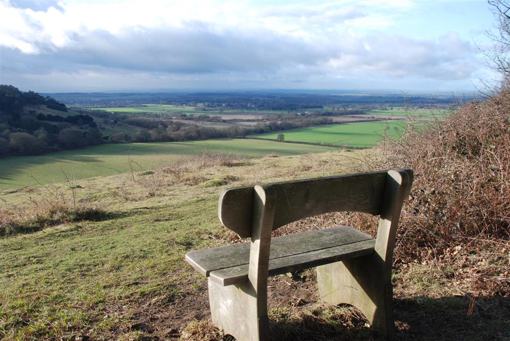
Views of the Vale of Oxfordshire
Mike Jackson © RGS-IBG Discovering Britain
Before you set off, take time to look at the Natural England information board. When you are ready, wander into the beech woods behind the car park.
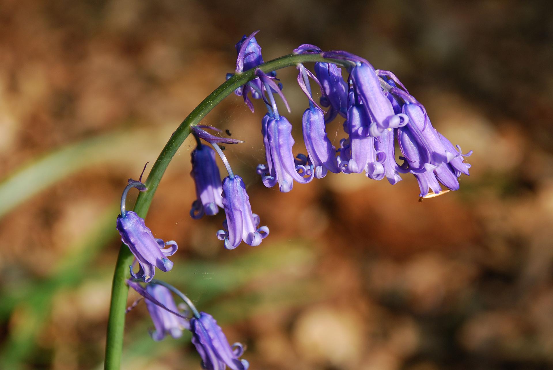
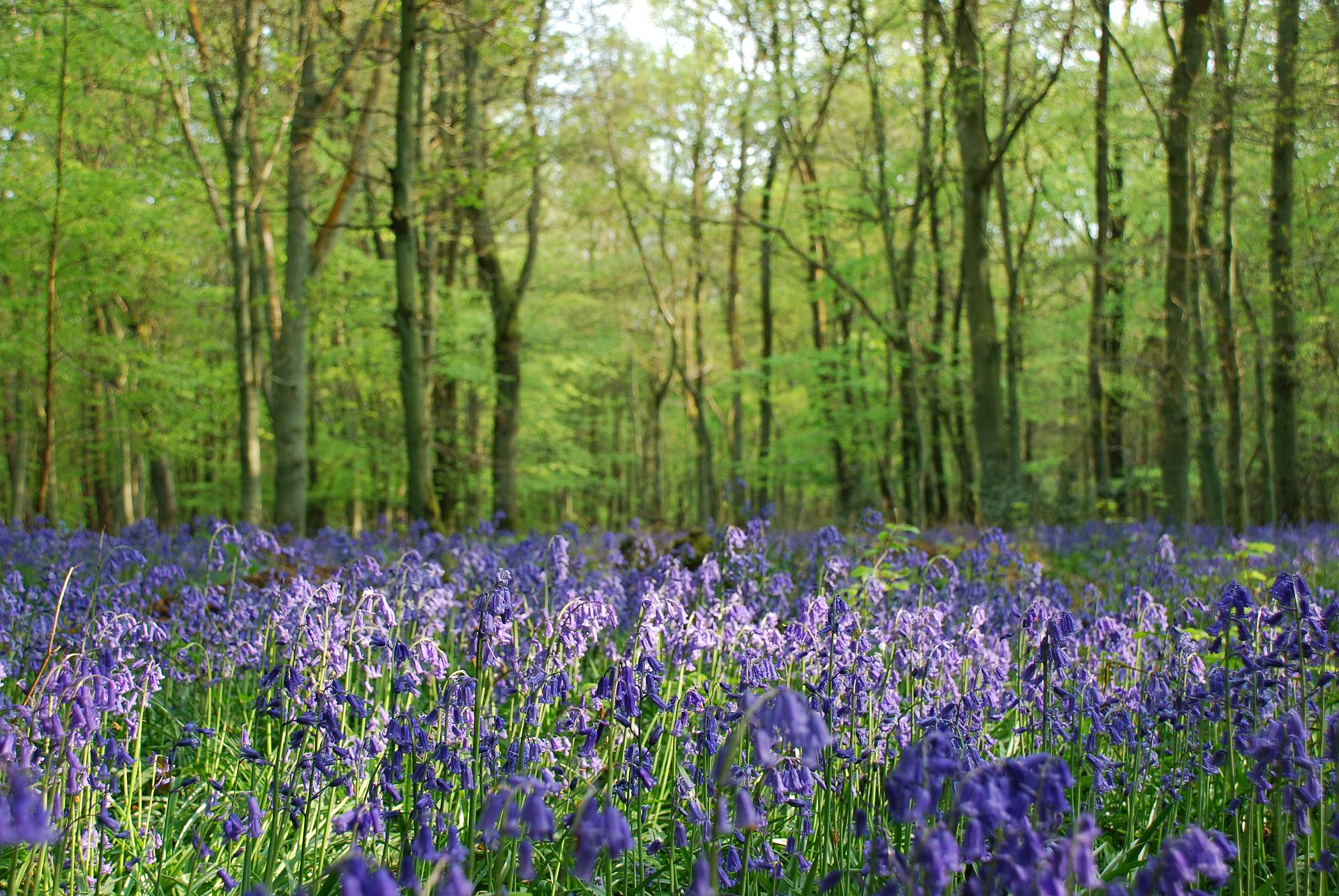
If you are lucky enough to be here in late April or early May then you will be amidst a carpet of bluebells. After a shower or when the air is heavy then not only will your eyes be filled with a spectacle of colour, but your nose will be treated to the fabulous perfume in the air.
Around half of all the bluebells in the world are found in Britain. Although they survive in many habitats, they particularly like moist and shady conditions, so the beech wood here is ideal. Bluebells store energy in a bulb beneath the ground so they grow quickly in the spring and complete their life cycle before the trees come into full leaf.
There are two varieties in Britain – a native species and the Spanish bluebell, which was introduced in the seventeenth century as an ornamental plant. Unfortunately the Spanish bluebells are highly invasive and threaten our native species. They have also crossed with the native bluebell to create fully fertile hybrids.
The bluebells here in Cowleaze Wood are natives. They have narrow leaves and the flower stem droops to one side at the top. The flowers have long narrow trumpets, a strong scent and are deep violet blue (although you can find the occasional white ones that are missing their blue pigment). By contrast, Spanish bluebells have stiff upright stems, their flowers are wider and usually stick out all the way round, and they have little or no scent. Please remember that native bluebells are protected by law, and although it is not illegal in England to pick the flowers, it is illegal to dig them up.
Native bluebell
Mike Jackson © RGS-IBG Discovering Britain
From the woods, return to the information sign and cross the road with care. Go through the gate and follow the footpath, keeping the fence on your left. Go past an outdoor seating area. After about 100 metres, look for a gate in the fence on the left hand side. Go through the gate and stop by the two benches.
You are now standing at the top of a steep slope looking west over the Vale of Oxfordshire. Slopes like this are usually termed escarpments.
Under your feet is 100 metres of chalk rock. Chalk was formed during the Cretaceous period about 65 – 90 million years ago when global sea levels were much higher. Northern Europe, including Britain, was covered by a shallow and warm sea. Over millions of years, the remains of microscopic sea creatures accumulated on the bottom of the sea and these were gradually compressed, eventually becoming chalk.
The chalk here is part of a long band that underlies much of southeast England, including the famous white cliffs of Dover. The escarpment here marks the divide between the chalk and a different type of rock that lies underneath the lower ground of the Vale of Oxfordshire called upper greensand and gault clay.
Chalk rock is porous, which means that water can pass through it, as opposed to impermeable rock which cannot absorb water. So rain water that falls here is soaked up by the ground. Slowly, the water passes down through this hill until it reaches the layer of impermeable rock at the bottom of the escarpment.
With nowhere to go, it emerges from the ground as springs. Thus one characteristic of this escarpment is a series of so-called spring line villages along the base of the slope, where humans settled to take advantage of the source of fresh water. Later we will walk through Lewknor, which is one of these spring-line villages but before we get there, lets look at the incredible variety of plants and insects that live on the chalk escarpment itself.
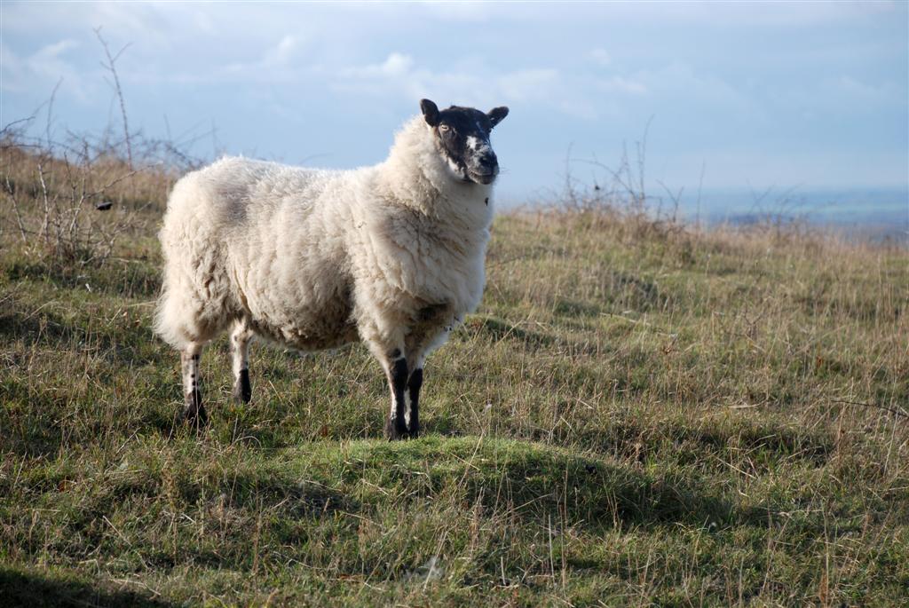
Sheep grazing chalk grassland
Mike Jackson © RGS-IBG Discovering Britain
From the benches, follow the path to the right. Keeping the fence on your right hand side, continue for about 100 metres and stop by another bench.

The mounds that you can see here and all around the reserve are created by yellow meadow ants. Natural England estimate that there are up to 100,000 ant hills on this reserve, each containing around 5,000 ants. That’s 500 million ants!
The function of the mound is to maintain an even temperature and humidity inside. Each mound is a network of galleries within which the ants tend eggs, larvae and pupae until they mature into adults. The ants vigorously defend their territory, which is why the mounds are spaced the way they are.
A queen can survive for around 20 years and is replaced when she dies so that the colony lives on. It is estimated that around 90% of the mounds here are active.
The ant hills have a different micro-climate and soil composition to the surrounding grassland because the ants bring up chalk from below the surface and this favours different species of fungi, lichens, mosses , grasses and other flowering plants. Look closely and you will see different plants growing on the sunny and shady side of the mounds.
This area is ideal for ant colonies because the ground is not disturbed by farming or livestock trampling. The ant hills grow approximately a litre a year and this figure is used to estimate when the land was last disturbed or ploughed for arable crops.
Yellow meadow ant
Sarefo (Creative Commons License)
Continue along the footpath as it descends. Stop at the next bench, dedicated to Fred Denton.
As you walk down the escarpment, you are walking across chalk grassland. The soil here is thin and rich in lime, and supports a variety of wild flowers. In one square metre there can be as many as 40 different species of flowering plants.
While this grassland might look totally natural, it is only this way because of human activities. The trees that once grew here were cut down many centuries ago and since then people have let their animals graze on these slopes. Without sheep and rabbits continually nibbling the grass, this land would quickly revert to woodland.
In fact, large areas of chalk grassland have been lost in the southeast of England since the 1940s. More intensive farming methods have led to a reduction in grazing and myxomatosis has devastated the rabbit population. Today, Natural England maintains the grassland here by keeping a flock of around 300 sheep on the reserve. Sheep graze the sward between flower stalks and this encourages a rich variety of wildflowers.
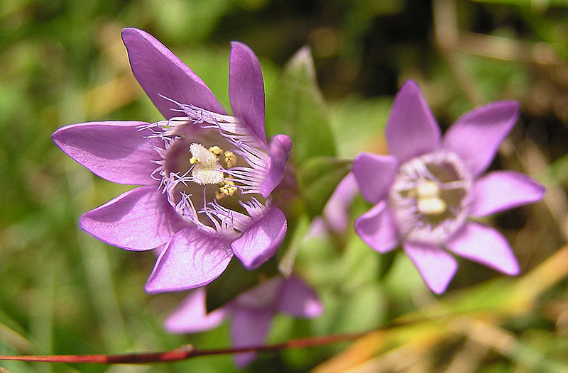
If you are here in summer, you should be able to smell the scent of wild thyme, basil and marjoram. Also look out for different varieties of orchids. In August and September you will see a spectacular display of the purple Chiltern gentian, which is the county flower of Buckinghamshire and is only found on chalk downland.
The wildflowers here attract a range of butterflies and other insects. Look out for the silver-spotted skipper (a small, rare butterfly, which is a strong, fast flyer), the chalkhill blue (an attractive silvery-blue butterfly seen feeding from purple flowers), the marbled white (a distinctive black and white butterfly), and the dark green Duke of Burgundy fritillary.
Chiltern gentian
Oswald Engelhardt (Creative Commons License)
Remain at Fred Denton’s bench for Stop 6.
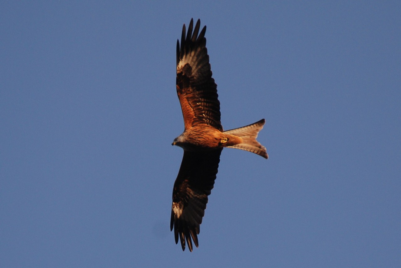
Look into the sky and you should be able to spot some magnificent birds of prey, red kites. While kites are the most common bird of prey found here, you might also see buzzards and even kestrels. Kites and buzzards look quite similar from a distance, but the kite has a forked tail and the buzzard’s tail is fan-like.
Red kites are scavengers, and were once very common. In the fifteenth century they were protected because they kept streets free of carrion and rotting food. Later in the eighteenth and nineteenth centuries they were hunted and persecuted by farmers who thought that they killed lambs. In fact they don’t kill anything larger than rabbits and they were probably feeding on the afterbirth of sheep.
The use of insecticides such as DDT on farms also contributed to their decline. DDT concentrates in animals at the top of the food chain and results in their egg shells becoming fragile. This had a huge impact on the number of red kites in Britain. Towards the end of the twentieth century, the breeding population of red kites had become restricted to just a handful of pairs in South Wales.
But conservation organisations did not want the species to be lost entirely. Here in the Chilterns, there was a reintroduction programme by Natural England and the Royal Society for the Protection of Birds. Between 1989 and 1993, thirty birds from Spain and Sweden and one from Wales were released. By 2002 there were 139 breeding pairs. A great success!
Red kite
Mike Jackson © RGS-IBG Discovering Britain
Continue following the path as it goes downhill and around the hill to the right. Go through a gate and stop at the next bench.
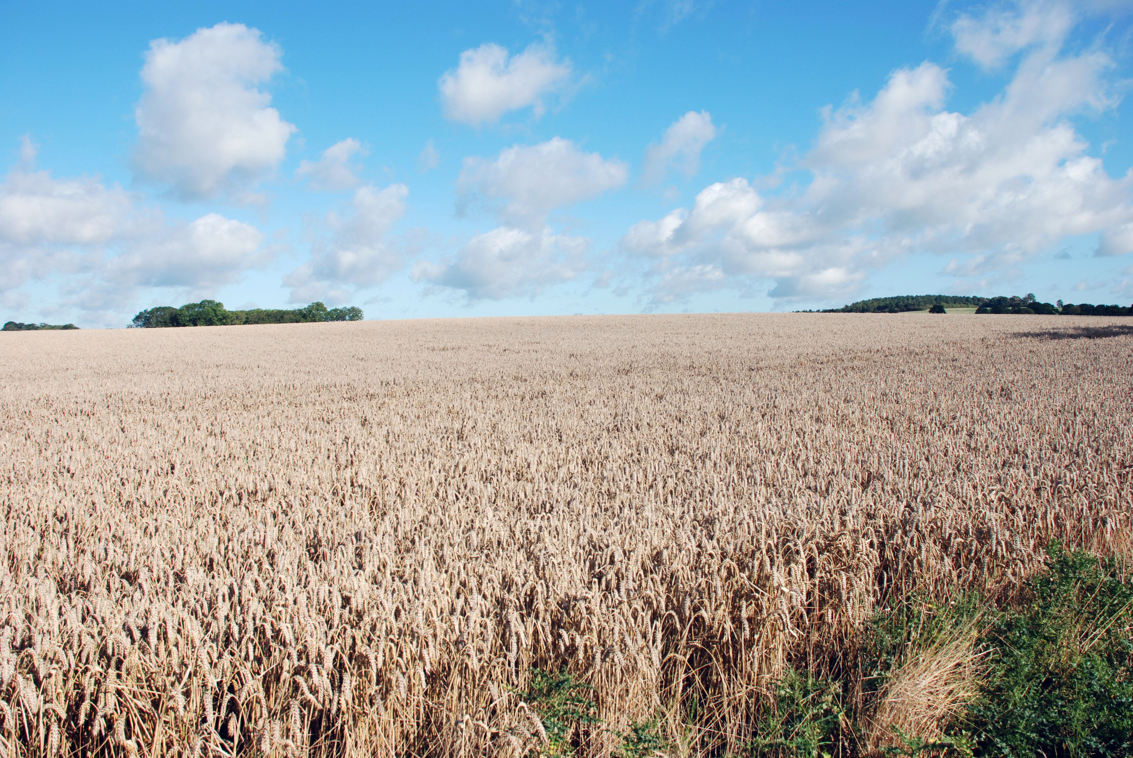
From here, there is a magnificent panoramic view of the Vale of Oxfordshire. The soil in the valley here is very fertile so it is used extensively for arable farming (crops). You can see that each field is very large, but the landscape didn’t always look like this.
In the Middle Ages (from the 5th to the 15th century), the land around the village would have been open and typically would have been farmed using a three field system. A different crop was grown in each field and the crops were rotated each year with one field being left fallow. This method meant that the quality of the soil did not decline and the land remained productive.
Although the fields were open, they were split into furlongs 220 yards wide and further subdivided cross-wise into strips covering around half an acre. Each villager was allocated a certain number of strips at the beginning of the season, generally by lot. The system of drawing lots meant that an individual farmer had strips that were widely scattered and no one farmer got all the best land. Open field farming came to an end when the land was enclosed. Although some enclosures occurred as far back as the twelfth century, most took place between 1750 and 1860. Here at Lewknor, an Enclosure Act was passed in 1810.
Over more recent decades, increased mechanisation of farming has led to the creation of bigger fields. Today you will probably find wheat, oil seed rape and beans grown in rotation. Beef cattle are also fattened off the grass fields.
Wheat field
Mike Jackson © RGS-IBG Discovering Britain
Remain at the bench for Stop 8.
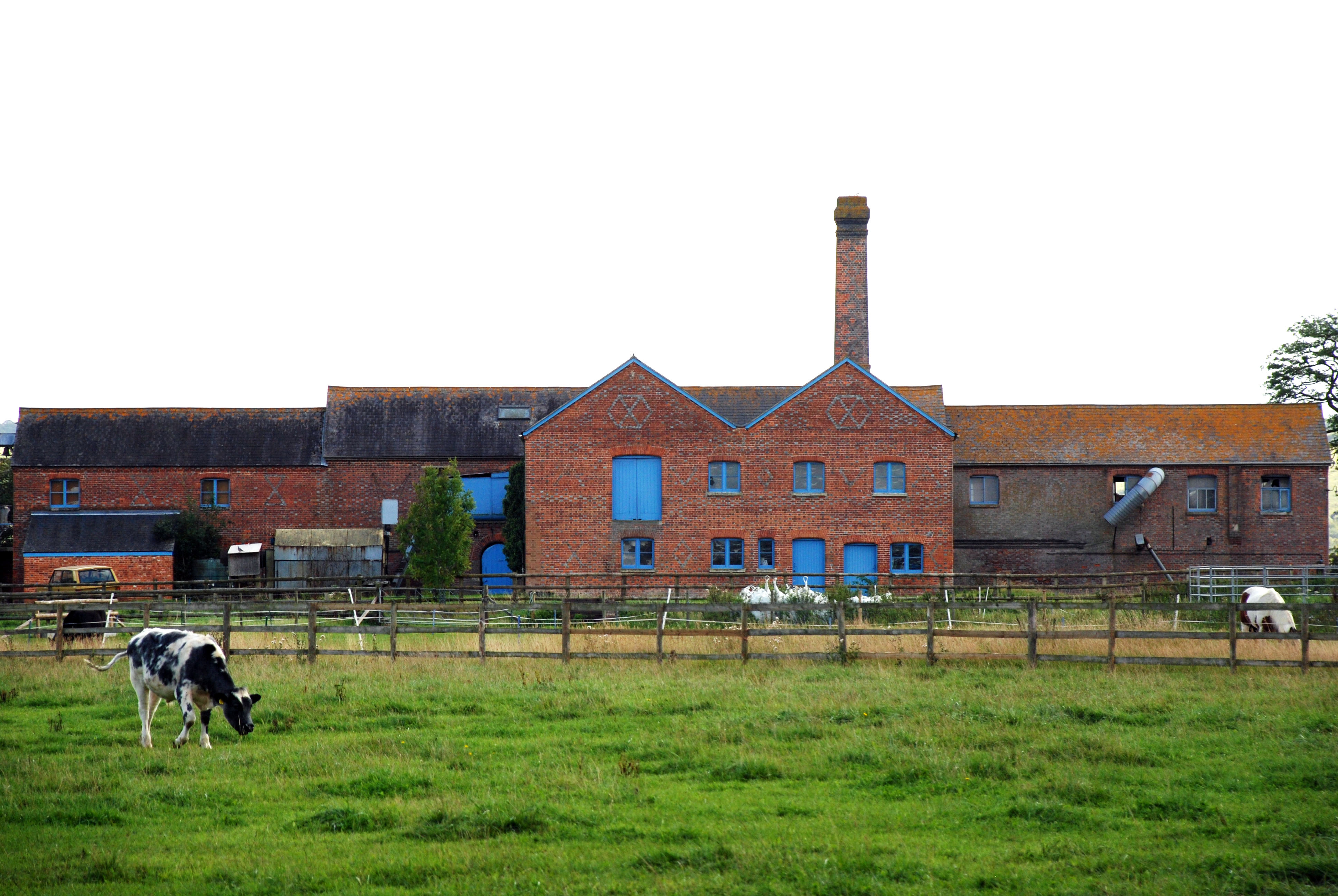
Look straight down the escarpment – across the fields is a group of farm buildings including a white farm house. If you look just beyond it and to the left you should be able to make out some red buildings with a chimney.
This is the home farm of the Shirburn Estate, a nearby stately home. The Sixth Earl of Macclesfield owned the estate, and he had a reputation as an experimental farmer. In 1856 he erected these factory-like buildings which earned the farm its current name – Model Farm.
The innovative buildings included covered yards which provided dry and healthy accommodation for cattle with a system for collecting and storing manure. Around 50 acres of land was irrigated as a water meadow, which was said to rival Blenheim Park.
The farm also made extensive use of machinery and steam power. You might be able to make out the chimney of the engine house which contained a 12 horse power steam engine. This provided power for a combined threshing and winnowing machine, a chaff-machine, a mill for grinding corn, a machine for crushing oats and beans, an oilcake-crusher and sawing-machines.
People came from all over the country to see the farm. It was even glowingly reviewed in the Illustrated London News of 1857:
“ We must not fail to remark the very excellent example the Earl of Macclesfield has set the landed gentry by so practically and usefully placing before them the result of his experience and knowledge in this set of buildings, and we hope many gentlemen may be disposed to follow it.”
The Model Farm, Shirburn
Mike Jackson © RGS-IBG Discovering Britain
Remain at the bench for Stop 9.
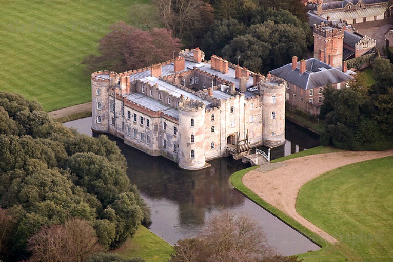
Look to the left of Model Farm and you should be able to make out Shirburn Castle peeping out of the woods. This wonderful fourteenth century castle would not look out of place in a Sleeping Beauty movie. Unfortunately, it is not open to the public, but it does have a fantastic history to tell.
The castle is square with circular towers at each corner and is surrounded by a moat, just as a child might build a sandcastle. It was built in 1377 when there was a threat of French invasion. Much later during the Civil War, troops loyal to the king were stationed in the nearby village of Watlington. The castle was held for King Charles I until it fell to the parliamentarian Sir Thomas Fairfax in 1646.
The castle was bought in 1716 by the First Earl of Macclesfield. He turned the it into a grand country house and it remained the home of subsequent Earls of Macclesfield until this century.
The Second Earl was a President of the Royal Society and had a great interest in astronomy. He built an observatory at Shirburn from which he made observations of the great comet of 1743. He also played an important role in the adoption of the Gregorian calendar in 1752. This changed the start of the New Year from March 26th to January 1st. It was unpopular because many people believed they had been robbed of eleven days!
Shirburn Castle
© Air Frame Photography
Follow the path downhill. Just before the gate, turn left across the field for about 50 metres and stop by an isolated juniper tree.
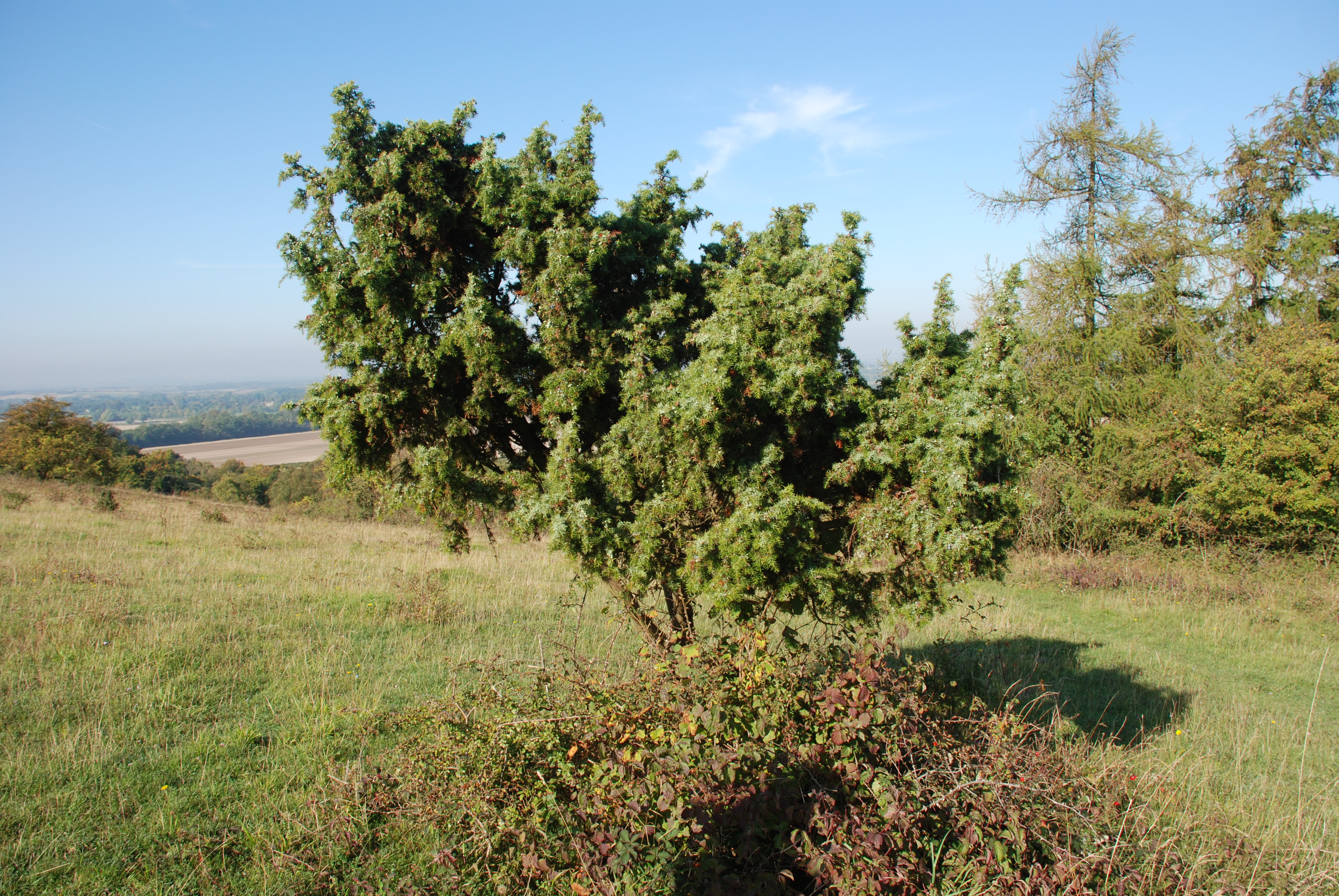
This is a juniper tree. There are only three common junipers native to Britain and they are now steadily declining with strongholds in the north and west of the Scottish Highlands and here in the Chilterns.
The Aston Rowant National Nature Reserve has been given the designation of Special Area of Conservation partly for its population of common juniper trees. Some of the insects that thrive on juniper are also extremely rare and encouraging young juniper plants to establish is important to their survival.
Take a look at this tree and see if you can see any berries. Juniper berries start out green before turning a purple-black colour. If you see any mature dark berries, try tasting one!
The use of juniper goes way back in history. In the Middle Ages, the scent of juniper was believed to ward off plague, witches, evil spirits, curses and contagious diseases. For hundreds of years, juniper berry has been a herbal remedy for urinary tract problems and is an old folk remedy for gout. Juniper berries have also long been used in cooking to flavour many meats especially quail, pheasant, veal, rabbit and venison.
Today they are perhaps best known for flavouring gin. Gin is enjoying a resurgence in popularity and is now flavoured from a range of botanical products such as coriander seed, orange peel, licorice root and angelica root, as well as the traditional juniper.
Juniper tree
Mike Jackson © RGS-IBG Discovering Britain
Return to the gate, go through it and turn left down the track. Stop by the gates of a house called Hill Farm.
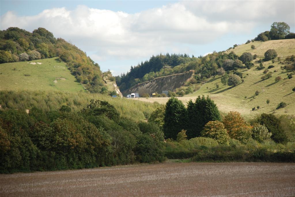
Although you've been surrounded by the sounds of nature on this walk, you can also hear a more unnatural noise: the M40 motorway. If you look back up the escarpment you should be able to see the cutting in the chalk that was made when the M40 was extended to Birmingham.
This cutting is known as the Stokenchurch Gap or the Aston Rowant Cutting. It is up to 47 metres deep and divides the Aston Rowant Nature Reserve in two. At the time it was built, there was a lot of opposition. Opponents had suggested a tunnel or an alternative route but these were rejected by a public enquiry.
See if you can make out the old road which still winds its way up the steep slope along what was once the stagecoach route from Oxford to London. One section was so steep that extra horses had to be put at the bottom of the hill to help struggling stagecoaches get to the top.
Today some people regard the cutting as a manmade wonder. Next time you drive along the M40 through this cutting, take a look at the exposed chalk. The cutting is designated as a Site of Special Scientific Interest (SSSI) which states that it is a “stratigraphically important site providing the best Coniacian section in central England, part of the Upper Chalk succession”. In layman’s terms, this basically means that the construction of the cutting has revealed layers of rocks that are very significant to geologists.
The Stokenchurch Gap
Mike Jackson © RGS-IBG Discovering Britain
Continue along the lane for a short distance and stop at a signpost showing a cross with the Ridgeway National Trail.
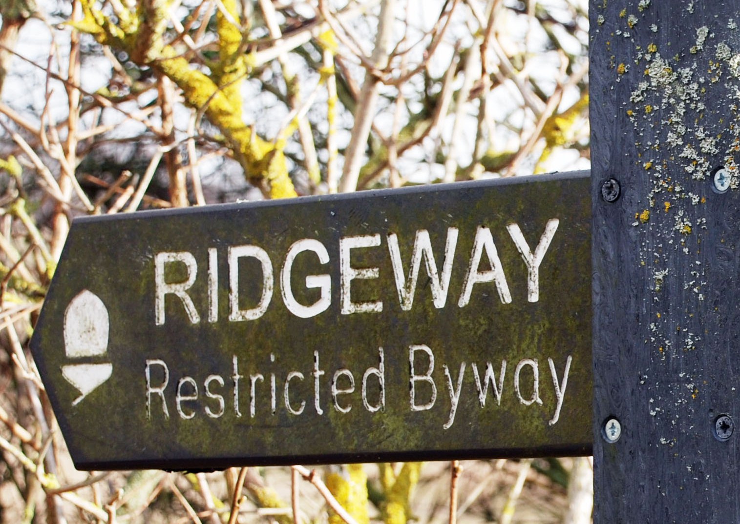
Just a short way from the modern motorway is Britain’s most ancient road. The Ridgeway It is about 87 miles long, following the chalk escarpment from Overton Hill near Avebury in Wiltshire to Ivinghoe Beacon north of Tring in Buckinghamshire.
This ancient path dates from Neolithic times, a period between about 4,000 and 2,000 BC, and was used by prehistoric people for travelling between settlements, moving livestock, and going on pilgrimage to sacred sites.
The Ridgeway, like other pre-historic routes, was never a single, designated road, but rather a complex of braided tracks, with subsidiary ways diverging and coming together. Although called the Ridgeway, the path did not follow the very top of the ridge. It was situated a little way down the slope so that travellers were sheltered from the wind. But the higher ground meant that the ground was relatively dry in contrast to the valley bottoms.
Today the Ridgeway is one of 15 National Trails in England and Wales.
Signpost for The Ridgeway National Trail
Mike Jackson © RGS-IBG Discovering Britain
Do not turn onto the Ridgeway, but continue straight along the lane for about 350 metres. Stop by a footpath sign on the left hand side into a field which has a hill with a small square shaped top.
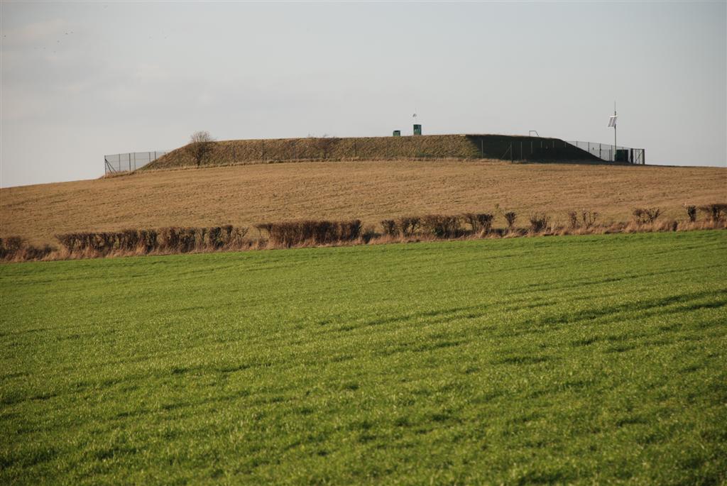
The small hill in this field is known as the Knapp. Today it is the site of a reservoir, but when it was being, constructed, evidence was found of an early Iron Age settlement and an Anglo-Saxon cemetery.
The village below the Knapp that we are heading towards is Lewknor, which is thought to be the earliest Saxon settlement in the area. The Saxon period was from the fifth century AD until the Norman conquest in 1066.
The Saxons divided the land into Hundreds. This was calculated as having enough land to support one hundred households. Each Hundred was headed by a hundred-man who was responsible for administration
and justice. Each also had a meeting point where men of the Hundred would discuss local issues and where courts were held. It is thought that the Knapp may well have been the meeting place for the Hundred of Lewknor.
The Knapp
Mike Jackson © RGS-IBG Discovering Britain
Continue along the lane until you reach the busy main road. Cross carefully and turn left. After a few metres you will find a path on your right that descends into Lewknor village. Follow the road to the junction with High Street. Stop at the Leathern Bottel pub which is opposite the junction.
For a shorter walk, turn left and follow the path along a hedge with the Knapp to your
right. Stop at the corner of the field and resume at Stop 18.
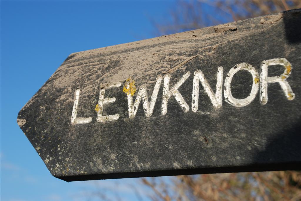
You are now in Lewknor village. The rather unusual name comes from the Anglo Saxon Leofecanoran, which means Leofeca’s slope, presumably after its owner, Leofeca.
As well as having an interesting name, there is a fascinating story about the ownership of the village. In the eleventh century, Lewknor became the property of Queen Edith, the wife of King Edward the Confessor. It is said that Edward and Edith once stayed at Abingdon Abbey, a Benedictine monastery in Abingdon about 15 miles west of here. While there they came across monks eating their meal and the queen was upset to find that they had only bread to eat. When it was explained to her that this was all the Abbey could afford, she decided to give Lewknor to the Abbey as an endowment to fund the boys’ morning meal.
Another major landowner in the parish is All Souls College, Oxford, which has owned land here since the end of the seventeenth century and still does today. The Leathern Bottel pub here dates back 450 years. It’s well worth dropping in for refreshments or lunch.
Lewknor village signpost
Mike Jackson © RGS-IBG Discovering Britain
From the junction opposite the pub, turn right along High Street. Stop when you reach the allotments, which are on the left hand side immediately after a row of cottages.
The allotments here were once Lewknor village pond. At the corner of the allotments, nearest the church, is the spring that fed the pond and also provided water for the village. In recent years, the water table has not always been high enough for the spring to flow. Before mains water arrived, the spring was the main source of village water and it is recorded that the local ‘launderess’ had to get help to fetch forty buckets of
water for each day’s wash.
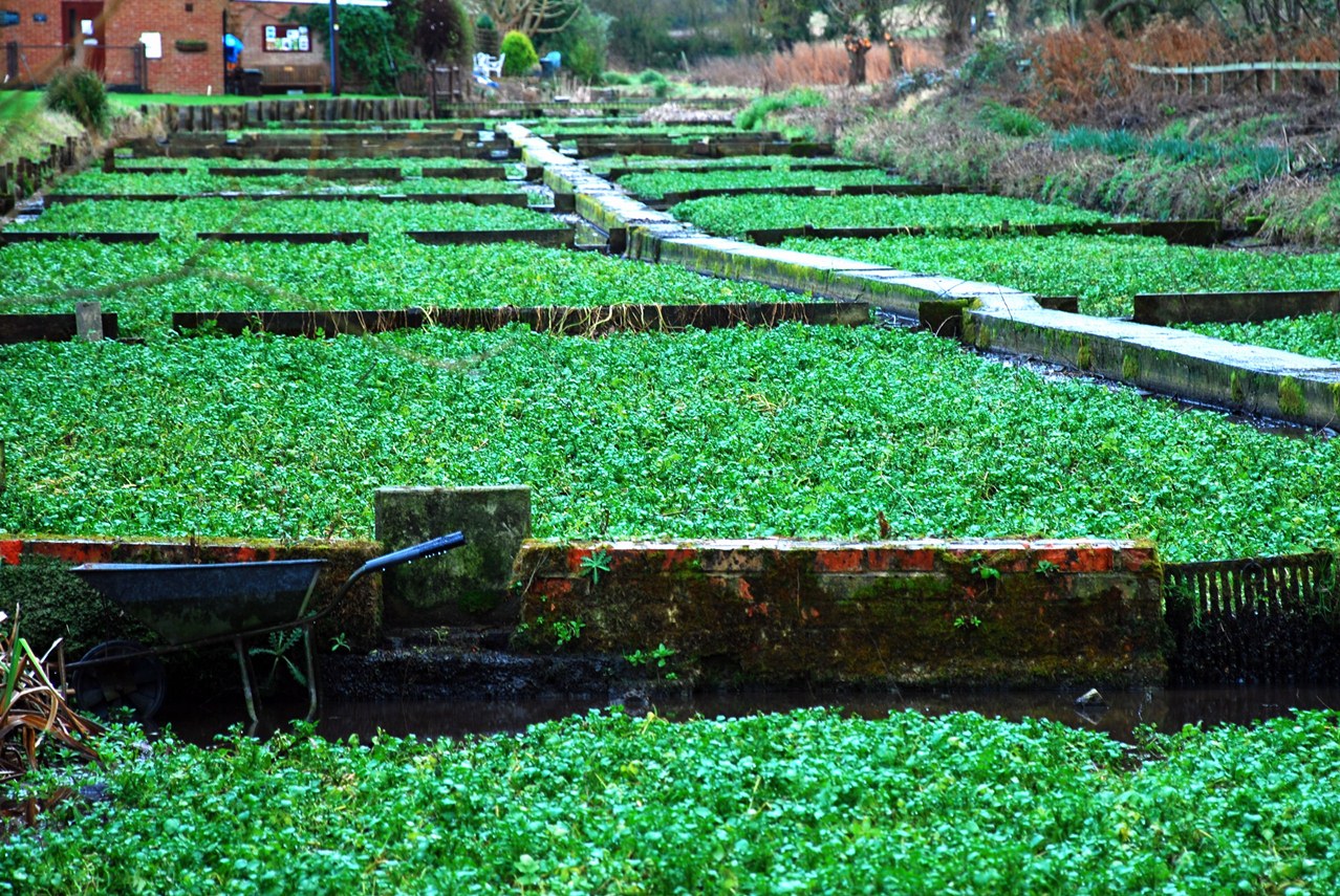
The streams from the spring also fed watercress beds. Watercress is a fast-growing aquatic plant and one of the oldest known leaf vegetables consumed by human beings.
Watercress needs flowing water to thrive, and the springs along the base of the chalk escarpment were ideal. Not far away at Ewelme, the Chiltern Society own and look after the watercress beds there.
The plant’s heyday was during the Victorian period with the development of the railway. It was packed into wicker ‘flats’ and tons of it transported to London. Street sellers would buy it and form it into bunches, which were eaten in the hand, like an ice cream cone. It was often eaten in sandwiches at breakfast time, though in poorer homes it was eaten on its own, which earned it the nickname ‘poor man’s bread’.
Ewelme watercress beds
Mike Jackson © RGS-IBG Discovering Britain
Walk a little further past the play area and turn left through the gate into the church grounds. Go through the lychgate and stop in the graveyard.
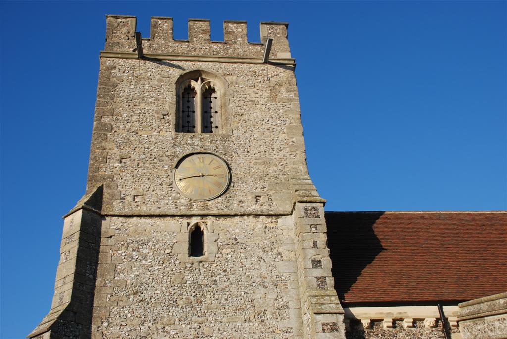
St Margaret’s Church is the oldest building in Lewknor, dating back to the twelfth century. Like most old churches, it has of course been rebuilt and added to over time. Some parts of the original building survive including the north chapel and the font.
Next to the church is the attractive village school. All Souls College in Oxford paid for the church chancel to be restored in 1845 and they also paid for the school to be built. The brick and flint walls are a common building style in the Chilterns, but there can’t be many primary schools in the country that still have a thatched roof!
Follow the path around the church tower towards the back gate and you will see a barn on the left. At first glance it might not look at all unusual, but in fact it is one of Oxfordshire’s most important medieval buildings. Inside is a timber frame thought to date back to the fourteenth century, making it the second oldest building in the village. It was originally constructed as a medieval hall house but was later abandoned and converted to a barn.
Lewknor Church
Mike Jackson © RGS-IBG Discovering Britain
Go through the gate in the back corner of the churchyard. Follow the path with a fence on the left hand side and go through two more wooden gates. At the next metal gate, go diagonally left across the field towards the end of the row of houses that you can see behind the trees. Cross the stream and go diagonally right across the field, over the stile and onto the road. Turn right and walk along Weston Road. Stop at the junction with Nethercote Lane.
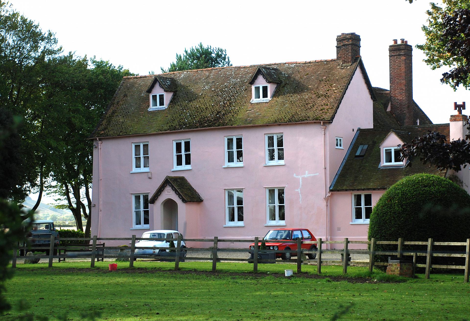
In the Middle Ages, there were three separate estates in Lewknor and three Manor houses and we'll see all three. The pink building is The Manor House. This is the site of the manor of Lewknor that we heard about earlier – it belonged to Abingdon Abbey and later fell to the crown in 1538 after the dissolution of the monasteries.
If you go a little further along the road you'll come to Moor Court Manor. Follow the road around the left hand side and you will notice that it is surrounded by a moat fed from the spring we saw earlier. Moats around manor houses were built to deter thieves rather than to fend off marauding armies.
The third manor, Nethercote Manor, was a short distance away. Nothing now remains after it burnt to the ground in 1871 in a fire which killed two children. Their graves are in the churchyard. Like Moor Court, Nethercote was surrounded by a moat and had a pigeon-house, stables, orchards and a fishpond.
The Manor House, Lewknor
Mike Jackson © RGS-IBG Discovering Britain
Return along Weston Road the way you came and follow it back into Lewknor village. At the junction with High Street, go straight across and retrace your steps back over the main road and up the lane. Turn right into the field where the Knapp is and follow the marked path. Stop at the corner of the field.
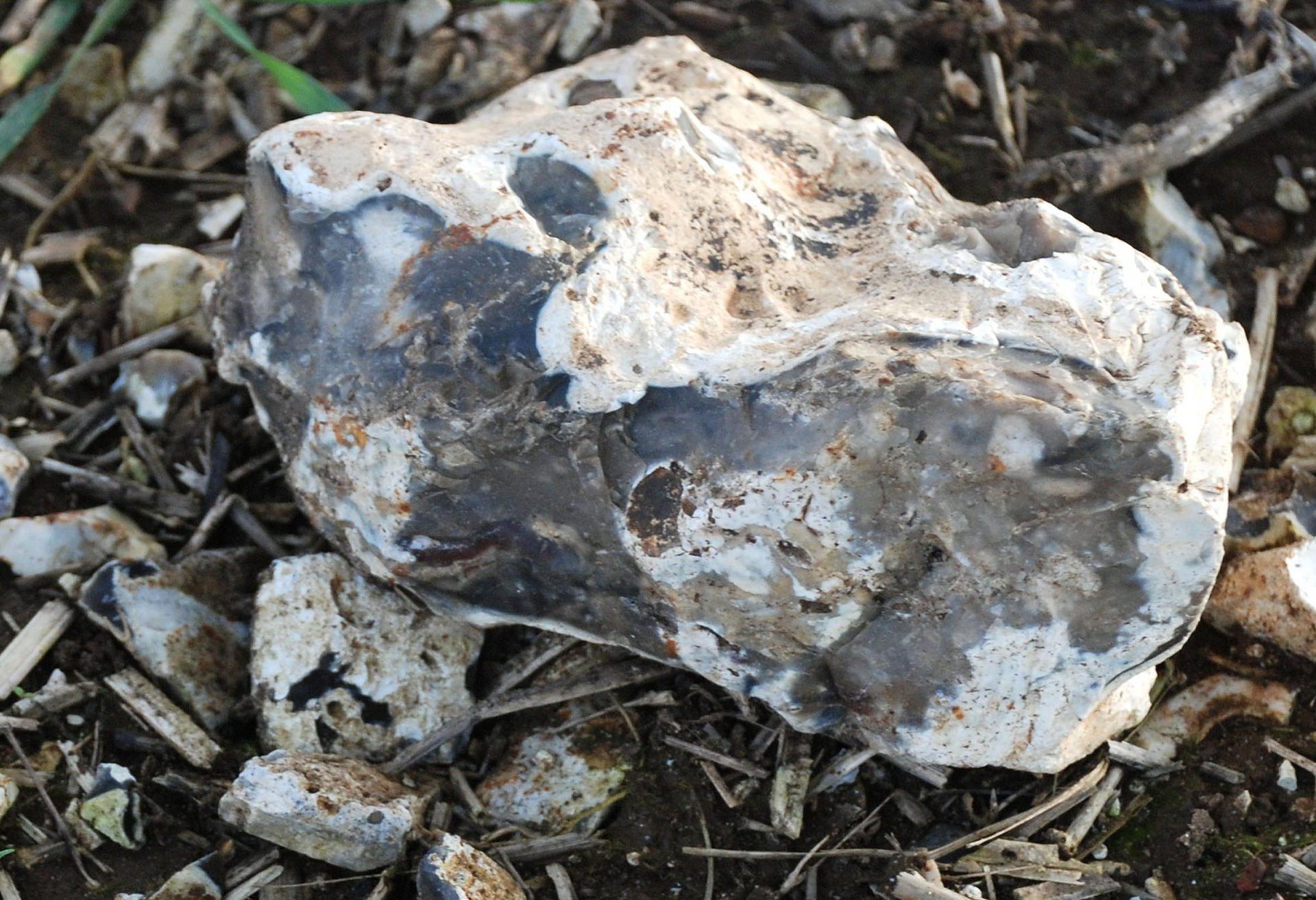
The fields here at the base of the escarpment are covered with lumps of angular rock. This is flint and these nodules of rock are found within layers of chalk and limestone rock. The closer you get to the escarpment the more flint you will find in the soil. Obviously chunks of rock within the soil do not make it particularly good for growing crops or grazing livestock.
There are several theories on how flint was formed. One is that they are the remains of sponges that grew on the floor of warm seas, filtering the water around them for food particles. When a sponge died, it literally dissolved away and the ooze left behind would be trapped amidst the other sediments and dead matter on the sea bed and, over time, harden into flint. Often, flints contain the fossils of coral, vegetation and other sea creatures.
Another theory is that dissolved silicon material from sponges and the silicon skeletons of certain plankton fill cavities in the sediment, such as holes bored by crustaceans or molluscs, and that this becomes silicified. This theory certainly explains some of the complex shapes of flint nodules that are found.
Flint is a hard rock, in contrast to chalk which is very soft which explains why you find many buildings in the Chilterns made of brick and flint but none of chalk.
Flint nodule
Mike Jackson © RGS-IBG Discovering Britain
Turn left along the path by the side of the field until you reach the Ridgeway path. Turn right and follow the Ridgeway for about 300 metres until you see a gate on the left hand side. Go through the gate, across the field and through the next gate into the wood. Follow the path through the wood and out of the gate at the far side. Stop in a place with a good view up the valley.
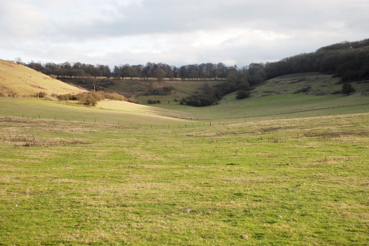
We are now going to walk up the valley on the left. All along the Chiltern escarpment you will see excellent examples of gentle-sloped v-shaped valleys like this one. V-shaped valleys are created as streams and rivers wear away the rock over thousands of years. But the strange thing here is that there is no stream or river in the bottom of this valley. This is known as a dry valley. We heard earlier that chalk rock is porous and allows water to soak through it. That is what happens here.
So how was the valley formed if the water soaks through the rock? There are two main theories. The one that is generally accepted is that such valleys were created during the last Ice Age. The ice sheets did not quite reach this part of England but this land would have been frozen – like conditions in Northern Canada and Alaska today. The normally porous chalk was made impervious by the frozen ground. During the summer thaw, water flowed over the land but because it was unable to sink into the frozen ground, it eroded the rock instead, cutting a valley shape. After the Ice Age when the land thawed, the chalk became permeable again. Any river water soaked into the ground and it became a dry valley.
There is another theory. As the ice sheets melted at the end of the last Ice Age, there was so much meltwater the ground could not absorb it all. This water would have flowed over the chalk surface without being absorbed, and thus eroded the rock to create a valley. As the amount of meltwater reduced, the chalk could once more absorb it and so the valley became dry.
A typical dry valley
Mike Jackson © RGS-IBG Discovering Britain
Walk up the valley following the power lines. When you reach the road, cross over carefully and turn left. After a short distance, stop on the footpath running parallel to the road.
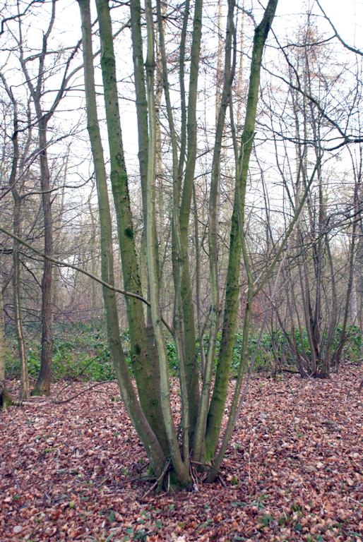
In ancient times, woodlands here in the Chilterns would have contained plenty of oak trees, as well as other species that are tolerant of acidic soil conditions, such as hazel, aspen, birch, hornbeam, rowan, yew and holly.
Woodland was a valuable resource. In particular, people needed wood for fuel and building materials. But instead of cutting down whole mature trees, which then take many decades to re-grow, they used the technique of coppicing.
Coppicing means cutting trees down to near ground level to allow young shoots to emerge and every few years cutting them back again. This was a renewable way of harvesting wood. Look out for examples here. Coppicing also meant that trees did not grow to maturity and thus kept the woodlands quite open. The extra light encouraged wild flowers like the bluebells that we saw earlier.
At the end of the eighteenth century, the Chiltern woods became important for chair making and the nearby town of High Wycombe was at the centre of this industry. Beech was the preferred timber, so the mixed woodland was gradually replaced by predominantly beech wood.
Bodgers were at the centre of this craft. Bodging is sometimes used as a derogatory term but in fact it was a highly skilled traditional wood-turning craft. Bodgers would set up hovels in the woods and to cut and split wood and shape it using a simple pole lathe to make chair legs and stretchers. The last bodger to practice his craft was a man called Owen Dean, who was working in the woods until 1960.
A coppiced tree
Mike Jackson © RGS-IBG Discovering Britain
Continue through the wood back towards the car park where you started.
Not only is this a beautiful place for a walk, but there is an interesting story to tell based on the underlying porous chalk rock and the rain water that percolates through it. We have seen some of the characteristic features of chalk downlands such as a dry valley and heard about how the chalk has influenced trees and plants, insects and birds, livestock and crops, as well as the humans who have lived in this area.
Up on the escarpment we saw how the poor soil supports grassland rich in wildflowers, and how the lack of interference allows ants to thrive. In other parts, deliberate grazing by sheep maintains the grassland. In the lovely woods, we have seen the trees that typically grow in acidic soil conditions and the ways in which humans have made use of the wood as a resource.
Down in the valley, we saw the point at which chalk hills meet the clay of the Vale of Oxford and how this has shaped human settlements and activities. The geological characteristics have created springs and, in turn, spring-line villages such as Lewknor. The springs and rich soil support agriculture and market gardening across this area.
We have also seen how humans have travelled across this chalky ridge – from the ancient pathway of the Ridgeway to the modern motorway, whose spectacular cutting exposes the chalk. And flying above the hills are the magnificent red kites, which have found a home here.
We hope that you have enjoyed this walk as much as we have in creating it, and that you now know a little more about the landscape of the this stunning escarpment.
Bluebells in Cowleaze Wood
Mike Jackson © RGS-IBG Discovering Britain

- Go on a voyage of discovery in the stunning Chiltern Hills
- Walk an escarpment with views of the Vale of Oxfordshire
- Discover how the rocks under your feet shaped the land
| Location: | Stokenchurch, Oxfordshire |
| Start and finish point: | Cowleaze Wood, HP14 3YL |
| Keep an eye out for: | Bluebells in Spring, wildflowers and butterflies in Summer |
| Find out more: | The Chilterns Area of Outstanding Natural Beauty Aston Rowan National Nature Reserve
|
Thank you to -
Mike Jackson FRGS and Gary Gray FRGS for creating the walk, providing photos and audio commentary
Jenny Lunn and Caroline Millar for editing the walk materials
Rory Walsh and Sam Carlsson for assistance
Damien Dyer of Air Frame Photography, Victoria County History and The Chiltern Society PhotoGroup for kind permission to reproduce images from their collections
Joanna Wells and her family for testing the walk on a very wet bank holiday
"I liked to persuade myself that the Chiltern landscape, with its folds and free-lines and constant sense of surprise, was what had shaped my prose, and maybe me too."
Richard Mabey