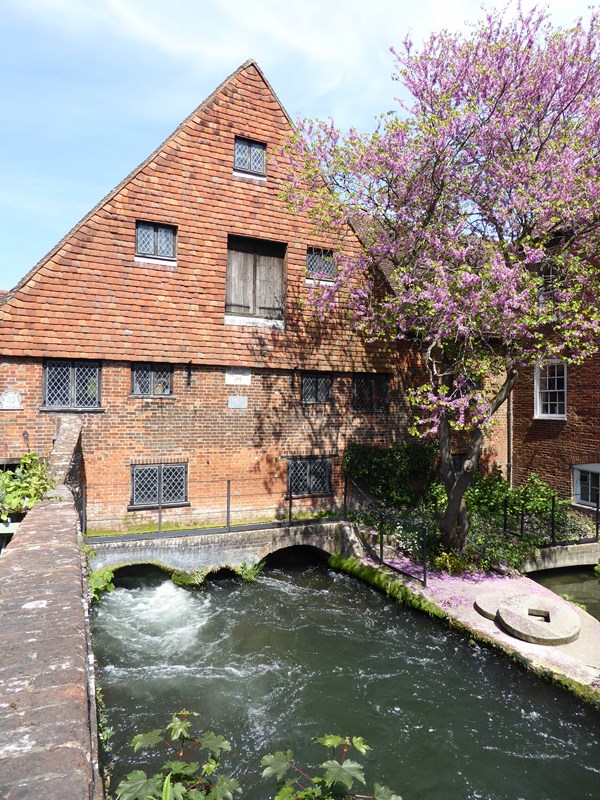
We begin exploring the River Itchen at one of the easiest places to see it. Restored and owned by the National Trust, Winchester City Mill is the oldest working water mill in the country. The building dates from 1744 but there has been a mill here since Saxon times 1,000 years ago.
Look down at the river rushing below us and we can see why. The river’s fast-flowing water provides constant power for grinding corn. Even when the mill wheel isn’t working, the water races by at around 25mph – faster than Usain Bolt can run.
The Itchen’s speed here is due to its location. We’re in the bottom of a valley, just downhill from the river’s source.
The Itchen Valley is at the edge of the South Downs, a large ridge of chalk that spans from Winchester to Beachy Head on the East Sussex coast. The Mill marks one end of the South Downs Way long-distance footpath.
The South Downs’ chalk hills are famous for their bright white colour. But they have other important properties. Chalk is an ‘aquifer’, a porous rock that absorbs water like a sponge. Rain on the Downs drains into tiny ‘fissures’ (cracks) in the chalk. The rock can store large quantities of water, a bit like an underground reservoir.
Pressure in the chalk means this water is constantly released at lower ground through a series of springs. The River Itchen emerges from a spring in Cheriton, a village seven miles from here. The river then flows downhill for 28 miles - through Winchester, Southampton and into the English Channel.
The Itchen is a ‘chalk stream’, a waterway fed by a chalk spring that flows over a chalk landscape. There are only 210 chalk streams the world - and 160 are in England. As we explore the Itchen we’ll discover more about these rare and beautiful waterways.
With the City Mill behind you, carefully cross the road and join the riverside path to the right of the bridge. Keep the river on your left and continue a short distance until you can see a small metal plaque on the riverside railings.
2 The Weirs
This pleasant part of the riverside is called The Weirs. A weir is a type of dam that controls a river’s flow and water level. We’ll see some in the Itchen today, and other features that show how people have used the river.
Before we follow the Itchen out of Winchester, let’s explore how the city developed beside the river. People lived on the hilltops of the Itchen Valley from the at least the Iron Age (800 BC – 100 AD). Like many British towns and cities though, Winchester’s origins can be traced back to the Romans.
After their invasion of 43 AD, the Romans formed towns using the natural lie of the land. The Romans recognised the River Itchen’s potential - for drinking, cooking, washing, trade, and defence. From 72 AD they established a town here called Venta Belgarum or ‘Town of the Bulgae’, after a tribe from Gaul (a Roman province in today’s northern France).
The river’s name meanwhile is a mystery. It is known that before the Romans arrived, the Itchen flowed in two major channels. To reduce flood risk, and boost defences, the Romans diverted the one here around Venta Belgarum’s town walls.
A small bit of the Roman wall survives nearby* and Winchester’s roads still follow a Roman grid pattern. The entrance to Roman Winchester was a gated bridge over the river, where the bridge by the mill spans the Itchen today.
Notice the houses on the opposite riverbank. They line a road called Chesil Street. ‘Chesil’ is from the Saxon ‘ceosel’ or ‘cisel’, meaning ‘gravel’ or ‘shingle’. Before the houses were built, the riverbank here was a gravelly beach. A bit later, we’ll see how gravel is important for the river.
* If you missed the Roman wall, go back towards the mill and look for a set of steps to the left of the riverside path. The Roman wall is next to them behind a metal gate.
Keep following the path with the river on your left. When you reach a large redbrick building (a converted mill) spanning the river, turn right. Follow the path around the building to meet a signpost by a high stone wall. Turn left and follow the path, keeping the wall on your right.
When the remains of Wolvesey Castle appear on the right, turn left into College Walk. At the end turn right and pass some Winchester College buildings. Turn left at the end then continue through a gap in the railings and onto a footpath. A small stretch of the river will be on your right.
After a short distance, another branch of the river appears on the left. Continue until a large redbrick building appears beyond the field on your right. There should be sections of river on both sides of the path.
3 The Water Meadows
We are now in Winchester’s scenic water meadows and following in the footsteps of the poet John Keats, who stayed here during the summer and autumn of 1819.
Keats took daily walks through these meadows. One of his September strolls inspired his ode To Autumn, the “Season of mists and mellow fruitfulness”.
This famous opening line reflects one of the Itchen’s unusual qualities. The river’s constant flow from underground chalk means it has a constant temperature, around 10°C (50°F). When the water meets colder air it condenses, cloaking the river in fog. So perhaps a cold day inspired Keats’s “season of mists”?
The scenery has hardly changed since Keats' visits. To the right are the grounds of Winchester College while to the left are swathes of wetland. The River Itchen is the lifeblood of this poetic scene.
Here, where two channels line the footpath, is a good place to explore why. The Itchen is a ‘braided’ waterway. Instead of one large channel there are several smaller ones that meander around obstacles.
Look at both stretches here and we’ll see that, though separate, they share common features. They are both shallow, lined with plants, and as locals say “gin-clear”.
Look too for traces of chalk along the banks. We explored earlier how chalk absorbs rainwater. Through natural and man-made chemicals, rainwater is slightly acidic. When it enters the chalk though, a chemical reaction occurs. Chalk’s chemical name is calcium carbonate. Calcium is an alkaline, which means the chalk neutralises the rainwater’s acid.
This purified ‘freshwater’ encourages a diverse eco-system. Tiny molluscs can live in the water, while colourful flowers line the banks. Both encourage insects, like mayflies and dragonflies. The insects in turn attract birds and fish, including kingfishers, moorhens, and trout. Species from shrimp to shrews rely on the water meadows for food, shelter, and breeding grounds.
As we continue, take time to enjoy the sights of this special place. Listen for the sounds too – birds singing, insects buzzing, and even the splashing of water voles.
Continue along the winding path through the water meadows. Eventually you’ll reach a wooden gate before a road (Garnier Road). Carefully cross the road and re-join the path to the right of a house.
Follow the path through the trees. Again, branches of the river will appear on both sides. When the trees open out, pass a group of houses and allotments on the right. Soon after you’ll reach a gate marked 'The Hospital of St Cross'.
Go through the gate and head towards the large church-like building across the meadow. Stop at the nearest corner of the outer wall.
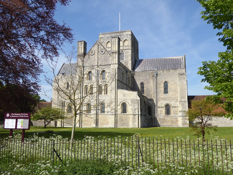
4 The Hospital of St Cross
On his daily walks through the water meadows Keats stopped here at the Hospital of St Cross. This isn’t a medical building but England’s oldest almshouse.
The Bishop of Winchester founded St Cross in 1136 to provide housing for “thirteen poor men, feeble and so reduced in strength that they can scarcely or not all support themselves”.
Today St Cross has 25 residents, known as the Brothers. Visitors are welcome too. Under the Bishop’s orders, the Hospital had to give travellers a ‘dole’ of bread and wine. We can still ask for it today, though the wine is now a cup of beer!
St Cross also provides a clue to how chalk streams are formed. If chalk absorbs water, how does the Itchen flow across chalk to the sea? Why doesn’t the water just drain away?
One reason is the Itchen’s downhill course. Stretches of the river flow too fast to soak into the chalk below. For another clue, look at the buildings of St Cross - especially the church tower and this outside wall.
They are made in brick and flint, a dark shiny stone. Unlike chalk, flint is strong and doesn’t absorb water. Chalk and flint are always found together. To discover why, we need to imagine a different scene.
Around 90 to 65 million years ago we would be at the bottom of a warm shallow sea. Over millions of years, the remains of tiny sea creatures slowly built up on the floor. These creatures were gradually compressed under the weight of the water and each other.
Chalk formed from their shells and skeletons, which gave the rock its white colour. Flint meanwhile formed from sea sponges and plankton. These creatures were rich in a chemical compound called silica, which dissolved then solidified again inside the chalk.
Flint is very important to chalk streams. The Itchen’s shallow, braided course comes from water ‘eroding’ (wearing away) the soft chalk ground. This exposes the harder flint. Flint makes an ideal river bed. Besides holding the water above ground, flint gravels help to keep the Itchen clean by ‘filtrating’ or sieving out impurities.
Keep the St Cross buildings on your right and continue to another gate. Go through it and follow a tree-lined path. Pass through another gate at the end then follow the path with a stream on your right. Continue past some cricket pitches and through two more gates to reach a tarmac road.
At this road, turn left. Go past the Road Closed barrier (it’s to stop vehicles), then stop when you reach a bridge over the river.
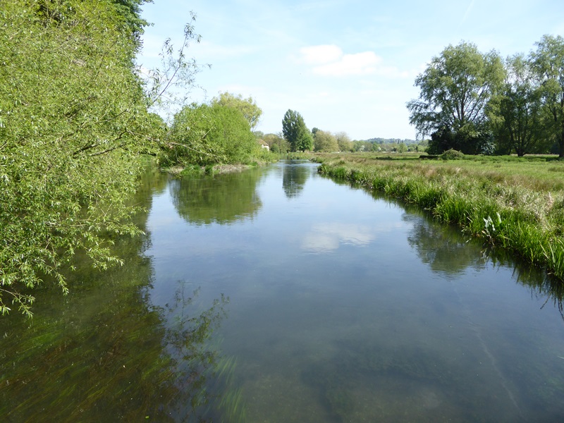
5 View of the River Itchen, Five Bridges Road
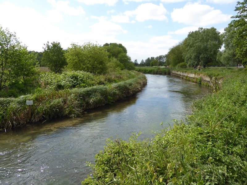
From Five Bridges Road we can enjoy great views of the river in both directions. Fittingly, we can also see two ways that people use the Itchen Valley.
The first is farming. Look for grazing cattle and sheep, plus a network of ditches and sluices in the fields. Many of these ditches date from medieval times. They divert water to and from the river to maintain the pasture’s moisture.
The pasture includes beds of watercress. Watercress flourishes here as it grows quickly in alkaline water all year round. The Itchen Valley is ideal for commercial watercress farming - and the nearby town of Alresford even has an annual Watercress Festival.
The other activity to spot is angling. There are angling notices throughout the water meadows, including the riverbanks here. Chalk streams are ideal for salmon, trout, lamprey and bullhead. The clear water helps them catch food, while riverside plants provide sheltered breeding grounds.
To maintain fish stocks angling is carefully regulated. The Itchen is also protected as an SSSI (Site of Special Scientific Interest). Such measures are very important for chalk streams as their fragile eco-systems are easily damaged.
A 2014 report by World Wildlife Fund found 77 percent of England’s chalk streams “in a shocking state of health”. One cause is fertilisers. If farm fertilisers enter the river, they make algae grow rapidly. Algae absorb oxygen and sunlight, so they can kill off other plants and animals.
Another threat to chalk streams is water companies. Stretches of the Itchen are extracted to supply the local area with drinking water. As our demand for water increases, so does pressure upon the Itchen and its wildlife habitats.
Five Bridges Road is a fitting place to think about the fine balance between people and nature. This used to be an access road for the A33 Winchester Bypass. Notorious for congestion, the Bypass was replaced by the M3 motorway and returned to nature. Just as the markings fade and greenery covers the tarmac, could our chalk streams vanish too?
Continue along Five Bridges Road until you reach a gate. Go through the gate then continue to another tarmac path. Turn left and follow this path through the trees (take care for cyclists on this section of the route).
Continue under an arched brick bridge and follow the path with the river on your left. Stop when you reach an information board beside a metal barrier spanning the water.
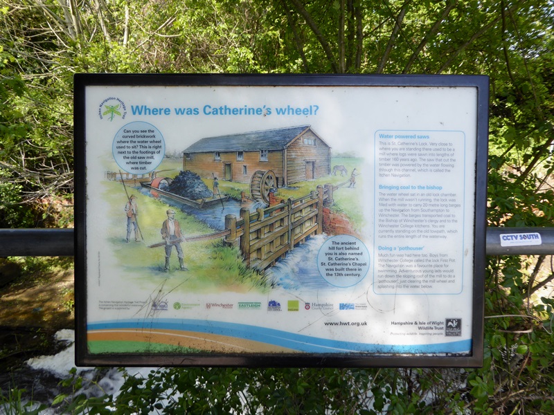
6 St Catherine’s Lock
We are now at the remains of St Catherine’s Lock. Locks are gates in a river that control the water level in sections. They allow boats to travel safely without running aground on the river bed.
This lock was part of the Itchen Navigation. A ‘navigation’ is a modified river. The Itchen Navigation was a 10-mile canal, created in 1720 by adapting the river between Winchester and Southampton.
We’ll find out more about the Itchen Navigation later. For now compare the river here to the winding streams we saw in the water meadows. Notice how this stretch is wider, straighter, and the banks are lined with bricks.
Also take in the scenery to the right of the path. St Catherine’s Lock is named after St Catherine’s Hill, a chalk peak that rises 97 metres (318 feet) above the water meadows. At the top, a copse of trees known as 'the Clump' mark the remains of a twelfth-century chapel.
People settled on St Catherine’s Hill centuries before then though. Iron Age tribes lived there from the third century. They created a ‘hillfort’ by ringing the hill top with a wall of earth. St Catherine’s Hill is the city of Winchester’s ancient ancestor.
Today's residents include plants, birds, butterflies, and a flock of sheep. The hill is now an attractive nature reserve. There are steps to the top, where visitors can enjoy sweeping 360-degree views over the Itchen Valley and trace the river's course through the Hampshire countryside.
The climb up St Catherine’s Hill is highly recommended if you have time. The steps are steep in places so do take care. When you are ready, go back down the steps and return to St Catherine’s Lock. Continue along the tarmac path with the river on your left.
There is a lower level path closer to the river but it is much rougher and narrower – you’ll also miss the next stop! After a short distance, you’ll reach a stone bench on the right of the path. Stop by this bench.
7 Stone bench, Itchen Navigation
Besides a pleasant place to rest, this stone bench is a memorial to the Itchen Navigation. It is shaped like one of the Navigation’s barges. The real ones were up to 70 feet long and 13 feet wide – almost the size of a London bus.
During the Itchen Navigation’s peak in the 1800s, barges transported over 18,000 tonnes of goods per year. They carried coal, stone, timber, salt, and corn. Despite this trade, the Navigation wasn’t a commercial success.
The Itchen’s naturally shallow course limited the amounts that barges could carry. Journeys were also rather slow. In an era before engines, barges were towed for days by horse. The Navigation’s real downfall though was another type of transport.
Do you remember passing under a brick bridge? This was part of the London and Southampton Railway. Opened in 1840, the line ran to the right of this footpath. The railway meant the Itchen Navigation’s trade monopoly collapsed and it closed in 1869.
In the 1930s the A33 Winchester Bypass was built on the other side of the railway. After the M3 opened in 1995, the Bypass was demolished and left to return to nature. Today this tranquil route is part of the Itchen Way long-distance footpath.
It’s remarkable to think that this riverbank once thundered with trains and traffic. But why did all these routes follow the Itchen?
The answer is the river gave Winchester direct access to the sea. Travelling along the river and its banks was also much faster and easier than crossing the surrounding chalk hills, which in turn were too soft for building long tunnels and bridges.
As a result the Itchen Valley has been a transport route for millennia. Roman and Saxon boats used it, while in the twelfth century stone from Caen in northern France was carried by river to build Winchester Cathedral. Our trail concludes with a similar pilgrimage.
From here the route continues to Winchester Cathedral. Follow the Itchen Way beside the river, until the path eventually meets a car park beside a stone bridge. Carefully cross Garnier Road again to the right of the bridge and continue with the river on your left.
Pass some tennis courts and a row of houses. When you reach a ‘Private No Access’ sign, turn right and follow the path up a short flight of steps. At the top turn left. At the junction at the end, turn left again. Cross another stone bridge over the river and follow the gravel path (with a stream on your left) to the corner of the College buildings.
Turn right and go along College Walk again. At the end turn left, then follow College Street past Jane Austen’s former house. Turn right through the Kingsgate stone arch and right again through another stone arch, and then turn left to enter the cathedral grounds.
Keep the Deanery Bookstall on your right and bear left to reach the Cathedral. With the Cathedral on your right, go up the steps or ramp towards the Shop and Refectory. Stop just past the Shop by a bronze statue on the right.
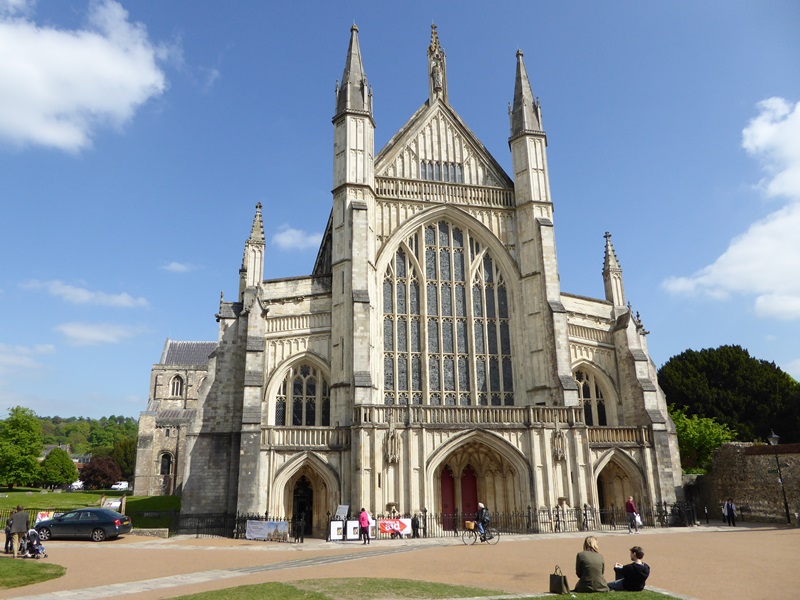
8 William Walker statue, Winchester Cathedral refectory
Winchester Cathedral is the city’s greatest landmark. It has the longest church nave in Europe and is world-famous as the burial place of writer Jane Austen. Parts of it date from 1093 though there was a church on this site from the seventh century.
Yet by the 1900s this magnificent Cathedral was literally on the verge of collapse. Wooden foundations were rotting away and, as the whole building sank, cracks in the walls and ceilings were large enough for families of owls to roost inside.
The problem lay underground. The Itchen Valley’s porous chalk and the river’s braided course mean Winchester has a high ‘water table’. The soil contains large amounts of water near the surface.
The Cathedral was built in the valley floor on soft peat. Peat is a muddy soil made from layers of dead vegetation. It builds up very slowly when ground is permanently waterlogged.
To stop the Cathedral collapsing, the wooden foundations needed replacing with concrete ones. So workmen dug a series of trenches. But before any concrete could be poured in, the trenches filled up with water. Enter this man, deep-sea diver William Walker.
As the inscription below his statue says, Walker “rescued the cathedral with his own hands”. For six years (1905 to 1911) Walker worked underwater to hand-build the new foundations.
He used 25,000 bags of concrete, 115,000 concrete blocks, and 900,000 bricks. The muddy water meant he did it by touch, in almost total darkness.
William Walker’s fantastic efforts saved the Cathedral. The crypt regularly fills with several inches of water, however, especially in autumn and winter. After heavy rain the Itchen Valley's underlying peat and chalk cannot absorb any more, so the area floods from underground.
This statue is a fitting place to end our trail. The story behind it shows how the River Itchen still shapes Winchester - and how a small waterway can have great effects. The Itchen and Britain's other chalk streams are a unique part of our landscape, heritage and culture. We hope you have enjoyed exploring this one.
If you have time, do visit the Cathedral. Entry is free. To return to the City Mill, keep the Cathedral entrance on your right and follow the tree-lined path path out of the grounds. Keep the William Walker pub on your left and continue ahead to join the High Street. Turn right and follow the High Street all the way to the end. The City Mill is past the statue of King Alfred the Great.
Your browser is out of date, and unsupported by this website. Please upgrade to the latest version to use this website.
Before the Norman invasion of 1066, Winchester was the capital of England. Its historic streets and stunning cathedral are still landmarks today. This trail explores the feature that helped Winchester to develop in the first place – the River Itchen.
The Itchen is a ‘chalk stream’, a very special type of waterway. There are only around 210 chalk streams in the world and 160 of them are in England.
As we follow a loop of the Itchen we’ll enjoy some of its prettiest sections, explore its various uses, and discover what makes this river so rare.
Follow the trail by clicking on the map pins or downloading the guides below
 Look down at the river rushing below us and we can see why. The river’s fast-flowing water provides constant power for grinding corn. Even when the mill wheel isn’t working, the water races by at around 25mph – faster than Usain Bolt can run.
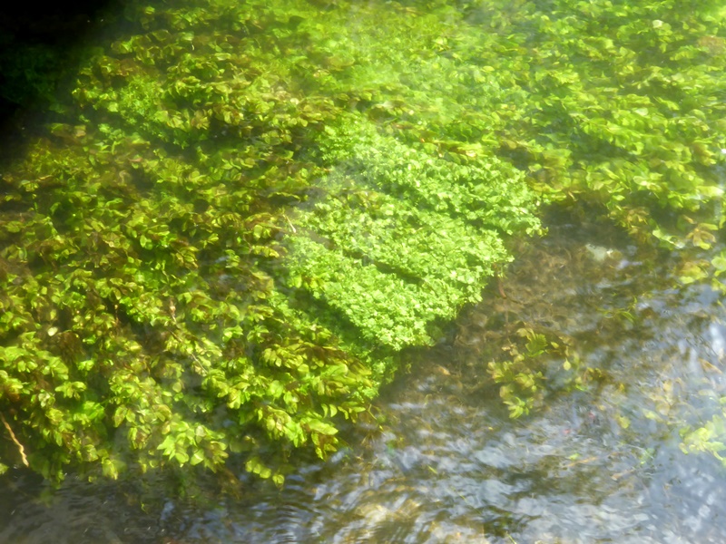

 Look at both stretches here and we’ll see that, though separate, they share common features. They are both shallow, lined with plants, and as locals say “gin-clear”.
 The first is farming. Look for grazing cattle and sheep, plus a network of ditches and sluices in the fields. Many of these ditches date from medieval times. They divert water to and from the river to maintain the pasture’s moisture.


 As the inscription below his statue says, Walker “rescued the cathedral with his own hands”. For six years (1905 to 1911) Walker worked underwater to hand-build the new foundations.