Welcome to Milton Keynes. Though often maligned in the popular imagination for its roundabouts and concrete cows, this is one of Britain's most radical and important towns.
The story begins with the end of the Second World War when Britain faced a severe shortage of decent housing. In 1946 the government established a plan to design and develop a series of 'New Towns'. The idea was to create brand new places for people to live, work and play and start a new life beyond the densely populated cities.
There were three waves to New Town building. All of them aimed to provide balanced communities of housing, employment and social facilities.
The first towns, built in the decade following the war, were mainly around London (including Stevenage and Hemel Hempstead). They focussed on social housing. The second wave, in the early 1960s, aimed for a mixture of social and owner-occupied housing. These were all outside the South East (for example, Runcorn in Cheshire).
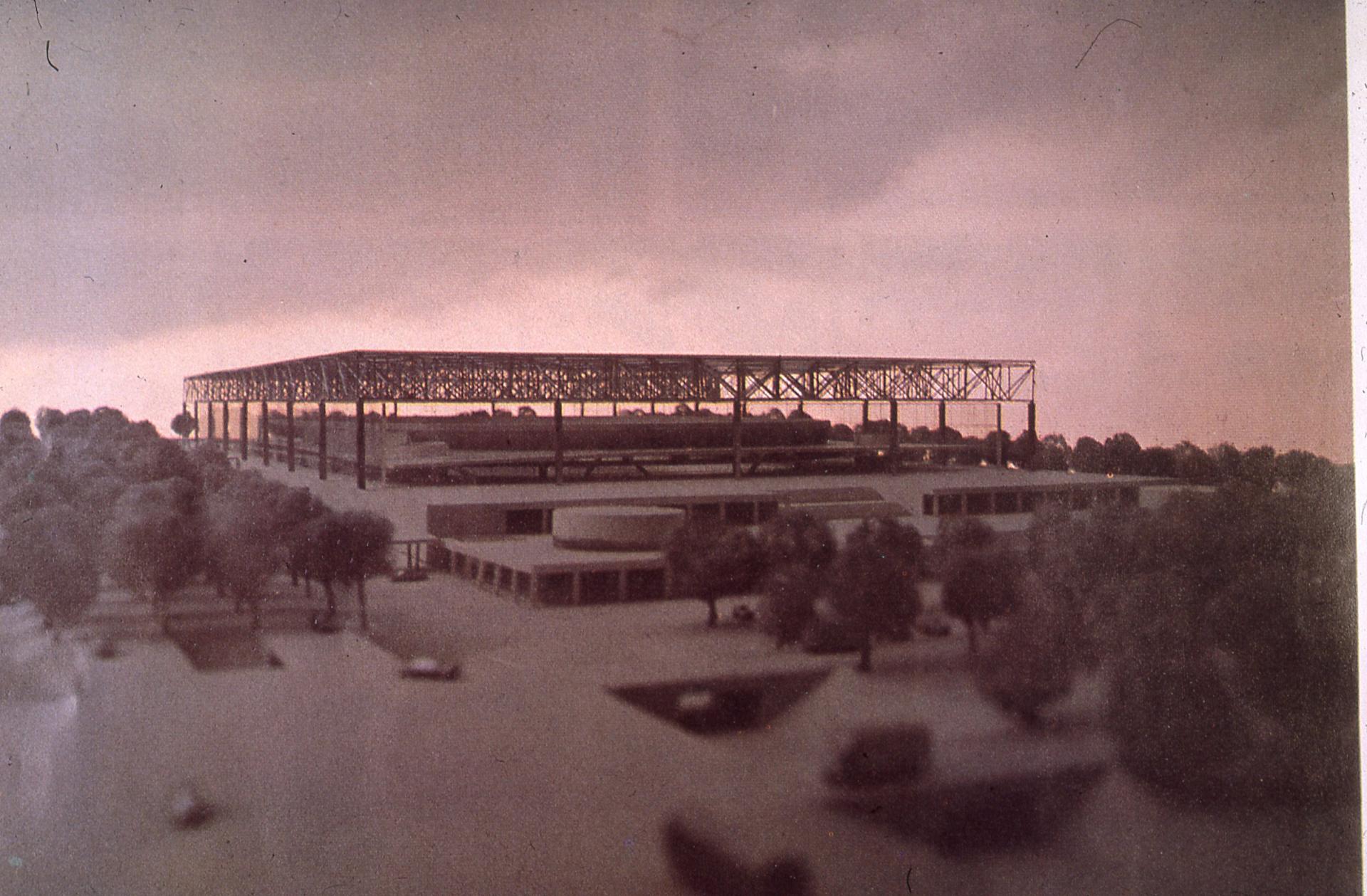
The third wave in the mid-1960s saw larger towns designed around car travel. They include Milton Keynes, Telford and Warrington. Milton Keynes was one of the last to be designed.
When it was designated for development in 1967, this area was largely farmland with a few villages. This location was chosen as it adjoined the main transport routes between London and Birmingham. Most new residents came from London to make a new life in 'the country’.
Milton Keynes was designed as a modern interpretation of the ‘Garden City’. The Garden City was an 1898 book by Ebenezer Howard. In it, Howard set out a vision for how cities could be planned to incorporate both town and countryside.
Garden Cities were designed in a concentric pattern with zones for housing, public spaces, parks and industry. The idea was that each city would be surrounded by a belt of countryside so they could be self-sufficient. Letchworth and Welwyn are Howard’s two Garden Cities in England.
In the 1960s councils were responsible for a significant proportion of house building within towns and cities (today it tends to be mainly private developers). In a bold move, development corporations were set up for every New Town so they could oversee all building and ensure the different elements of the town worked together.
Let’s find out how that has worked in Milton Keynes….
Walk to the end of the car park and continue along the tarmac footpath, bearing right at the V-junction. Turn right up the steps and at the path crossroads, turn left and carry on through the gate into the ‘grazing area’. Stop where you can see the white pyramid.
2 Campbell Park
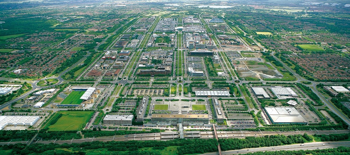
We are now in Campbell Park. Gaze around at the carpet of grass ahead and the cover of woodland behind. One of the remarkable things about Milton Keynes is the amount of open public space. The town has about 5,000 acres of parks and green spaces (equivalent to 7,500 football pitches!). This includes 15 lakes and around 80 miles of landscaped areas alongside the main roads.
Originally a rather flat, uninspiring area, Milton Keynes’ undulating landscape was created using spoil (excavated earth) during the town's construction. The intention was to make it look like the downlands of southern England. The Milton Keynes Development Corporation (MKDC) felt that people would be more likely to leave the crowded cities and move here if they thought they were moving to the countryside.
Campbell Park is not the largest of Milton Keynes’ open spaces but it is one of the most remarkable. In Britain it is rare to find a park in the heart of a city centre. Yet this convenient location means that it is used for a wide range of activities. including outdoor events, sports, wildlife education and public art. Unusually for a city park, the grass is also sometimes grazed by sheep!
Even more unusual though is the way the parks and open spaces are funded. Usually parks are maintained by local authorities and financed from Council Tax. But this is not the case here in Milton Keynes. The MKDC wanted to be sure that such a unique green landscape would be managed and protected forever, without having to compete for funds with other council priorities.
So in 1992 they created the Parks Trust. They endowed it with a substantial property and investment portfolio, worth around £20 million. The income from it pays for the upkeep and improvement of the city's open spaces. In this time of public sector cuts the Trust is proving particularly beneficial.
This is not the only time on this walk that we shall see that Milton Keynes does things a little differently.
Continue along the path, carrying straight on at all the junctions. Note the Sunken Amphitheatre: at this point you can leave the path and follow the fence at the top of the amphitheatre. Go over the style onto a tarmac path continuing to keep the amphitheatre on your left. (To avoid the style you can take the path up to the pyramid just before you reach the fence, then turning left and left again.)
Where the second set of steps leads down into the amphitheatre, turn right onto a tarmac path and then left onto a circular concrete path. Take second left from here, then half left and stop just after the underpass.
3 Underpass
The second remarkable thing about Milton Keynes is its roads. Visitors are often surprised that they have driven through a large town centre - traffic congestion is rare and the view is almost entirely of trees!
Tree planting was a priority during construction and collectively the roads create more than 100 miles of continuous woodland. This provides green corridors for wildlife to move around, something so many other towns and cities lack.
The town’s main roads form a grid of major highways, which are separated from the local roads serving individual neighbourhoods. The grid consists of ‘horizontal’ roads (actually running North East to South West) and ‘vertical’ roads (running South East to North West). The roads don't run exactly north to south as they fit in with clear lines created many years before by the M1 motorway and the main railway.
Remarkably, the town's planners discovered that the main street almost framed the rising sun on the Summer Solstice. So they tweaked the design so that, like Stonehenge, Milton Keynes would align with the cosmos! The road was even named Midsummer Boulevard. The move is a reminder that although we may think of Milton Keynes as a car and consumer-centric city, it was actually designed with utopian ideals.
Furthermore, the roads do not create a rigid grid. They follow the landscape, taking account of existing features. All the vertical roads are ‘ways’ and the horizontal roads are ‘streets’, which helps people understand the layout. The blocks of land within the grid usually form a residential neighbourhood.
The idea behind the grid of major roads is to allow fast, easy access to anywhere in the town. Many of these larger roads are subject only to the national speed limit. In fact, Milton Keynes' roads have recently been used to test driverless cars.
Without careful planning, the roads could have created a network of barriers, preventing people from getting around and creating lots of noise and pollution for residents. But this doesn’t happen here. The grid roads run between communities rather than through them. We have just safely passed from one neighbourhood to another without having to cross even a minor road and we will do so many times more on this walk.
Keep straight on and then into the underpass marked ‘Springfield’ and stop at the next footpath junction.
4 Redway junction
So far on our walk have you noticed ribbons of red tarmac? These red lanes denote Milton Keynes’ joint-use cycle and footpaths. Weaving over and under the roads they are unsurprisingly known as ‘redways’.
With over 180 miles of these ‘redways’ Milton Keynes has the largest network of traffic-free cycle and pedestrian facilities in the UK. Taking inspiration from Holland, MKDC hoped that providing dedicated cycle lanes would encourage high levels of bike use. While not on the same scale as in a Dutch city, bike usage in Milton Keynes is above the national average.
Many people use their own bikes but there is also a system of bicycle hire, similar to that in London, with 300 bikes and 42 docking stations. There are rules to encourage joint use of the redways and ensure that the network also welcomes walkers and runners. The signposts show how easy it is to get around. What’s more, the national Sustrans network links in to the redways on routes 6 and 51.
Although this New Town was designed with cars in mind, the segregated network actually gives Milton Keynes some of the best opportunities in Britain for sustainable local travel.
Directions
Turn right into Fishermead, keep straight on, eventually with housing on your left. At the first road intersection turn left into Porthleven Place. Continue straight along this road crossing two roundabouts. At the third, turn right along Fishermead Boulevard, cross the first roundabout and stop outside the small supermarket.
5 Fishermead local centre
We are now at a convenience store - what’s so special about it?
Well, each of the neighbourhoods within Milton Keynes’ grid was planned to be a community, not just a collection of houses. For this reason within each neighbourhood there are shops, social facilities and even schools.
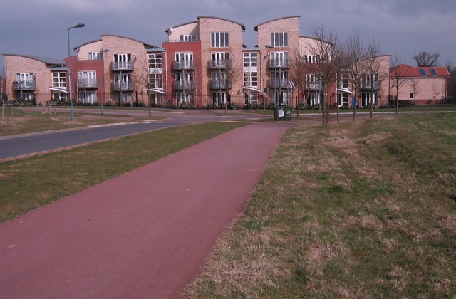
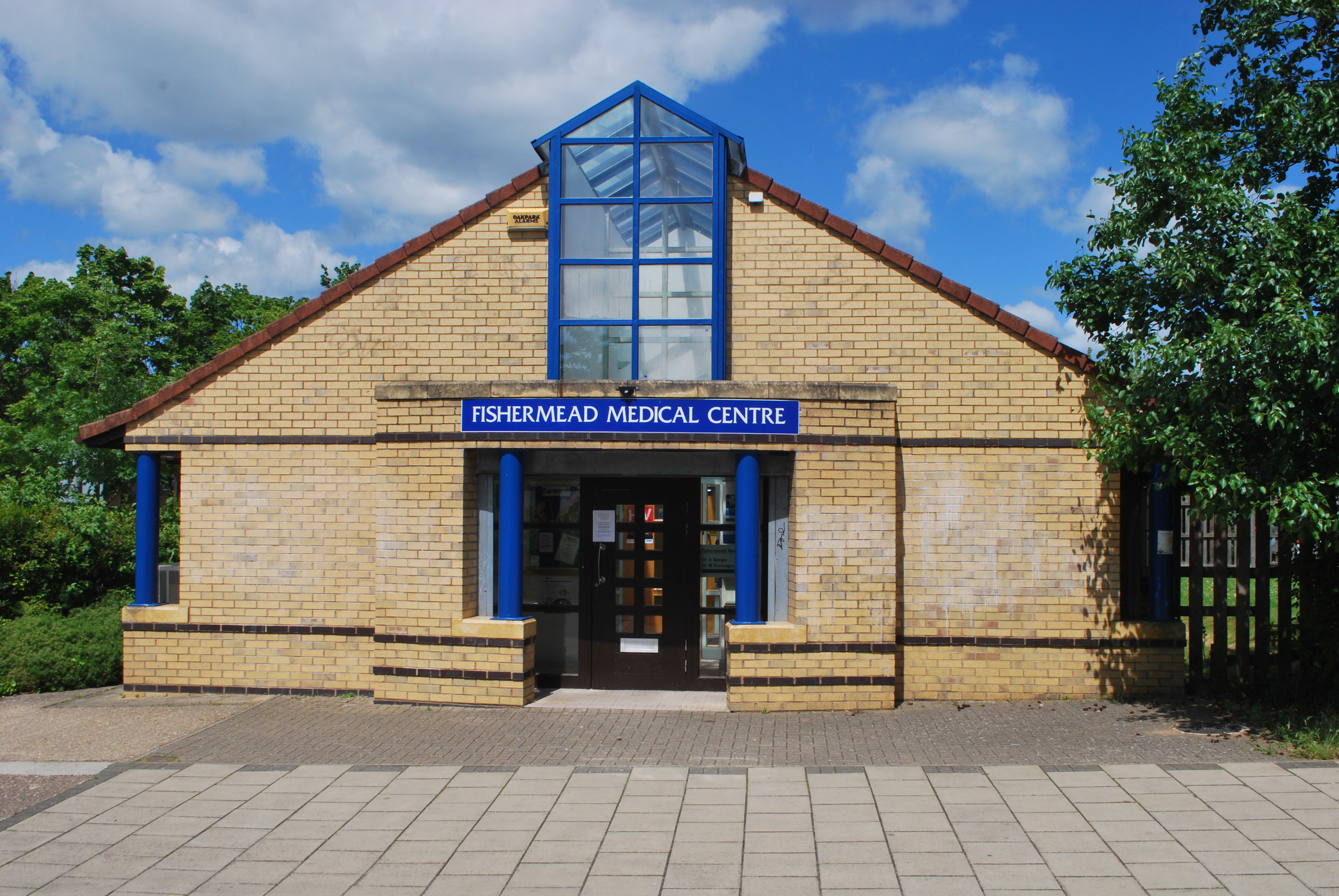
Next to the store you can see a multi-use community centre. Opposite is a children’s play area, with a medical centre nearby. The idea was that most of a household’s needs could be reached on foot or bike. This makes the neighbourhood somewhere that people want to spend time, rather than simply a place to retreat and sleep.
The houses were designed with as much care as the neighbourhoods. Look around - there are generous open spaces and tree-lined roads. There is a mixture of private, public and shared ownership homes sitting next to each other here - but can you tell which is which? In some cities it is easy but here the aim was to make all housing good quality and attractive, to create a social mix rather than divided communities.
Milton Keynes has also led the way in providing sites for people who wish to build their own house, something which is normally difficult where large developers purchase all the available land.
Besides the housing, it was decided early on that areas of employment should be distributed evenly across the grid. This makes Milton Keynes very different from traditional towns, where businesses and offices are often clustered together, leading to serious rush hour congestion. The even distribution of employment areas means that the traffic is more evenly spread here.
Milton Keynes has been successful in attracting employers to the city. In 1969 the Open University set up its HQ here and the town is one of the leaders in creating new jobs, especially in the service sector. The Open University was well suited to this new town as it was an innovative model itself. It is a distance learning institution, meaning most undergraduate students can study remotely wherever they are in the world, reducing costs and environmental impact.
The town is also one of the most entrepreneurial places in England, with a start-up rate twice the national average.
To get a sense for the vision behind the planning of MK watch this lovely short film (8 mins) on the BFI player
From the supermarket turn right along Pentewan Gate, going straight over the small roundabouts. At the end of the road, by the big roundabout fork half right onto a footpath slightly uphill, then left to a bridge over the main road. Continue straight on, keeping the large grey Xscape/casino building on your right. At the end of this building heading left through the car park for the underpass and turn right along Secklow Gate (not Avebury Boulevard) into Central Milton Keynes. Carry straight on with the car park on your left until you reach the large glass building.
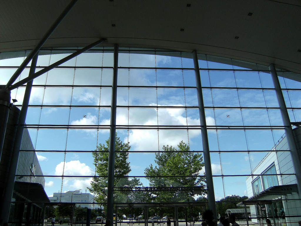
6 centre:mk
We have seen local shops, so let’s look at the other end of the scale. Here we are at centre:mk - when it first opened this was one of the largest shopping centres in Britain.
The design reflects many ideas of the leading mid-20th century Modernist architect, Mies van der Rohe, who inspired the city’s founders. The centre uses glass with minimal structural support, creating a light, open atmosphere allowing sunshine to penetrate right down to the shops. There are public artworks, clean lines and fluid spaces. Despite its young age, the centre is already a Listed building.
Even here we find more examples of Milton Keynes’ innovation. Deliveries for the centre come from above! Although you would hardly know it, the main road, Secklow Gate, passes through the centre above the shop level. This keeps traffic and shoppers separate, making a more pleasant experience all around.
Central Milton Keynes, however, is about more than just shopping. As well as the stations, libraries, theatres and cinemas of a traditional town, Milton Keynes boasts an adventure centre called Xscape with indoor real snow slopes, rock climbing walls, bowling lanes, a casino and even skydiving!
Although Xscape only opened in 2000, the city founders may well have approved. They were keen to create a city of innovation, offering everything the modern citizen could ever need, and this development shows Milton Keynes is still seeking to lead the way.
Have a look around centre:mk - but be careful, it’s easy to get lost! When you want to continue the walk, you need to depart from the north east end, adjoining John Lewis.
From the car park in front of John Lewis go diagonally right across the car and coach park, under an underpass and over a bridge into Campbell Park. Stop at the white pyramid.
7 Light Pyramid, Campbell Park
We are now back at Campbell Park. This is the Light Pyramid, created by artist Liliane Lijn in 2012 for the Parks Trust. The Light Pyramid is a beacon for Milton Keynes and perhaps a symbol of the innovation and optimism with which the town was designed. Situated at the easternmost end of Midsummer Boulevard and the highest point in the park, it is a good place to reflect on what we have seen.
The original plans for Milton Keynes were drawn up in the early 1970s, a time when energy was much cheaper and there were fewer environmental concerns. Consequently the car was prioritised as a mode of transport and the town was built at a comparatively low density with plenty of flyovers. Had it been designed a little later it would have been very different – most likely with a higher density of buildings, high-rise living and more public transport.
However, Milton Keynes’ wonderful open spaces reflect the willingness in the 1960s to spend money on big projects, something that we would find hard to do today.
The planners of Milton Keynes claim that the original conception has turned out to be remarkably flexible and that the town is well-able to deal with whatever the future may bring. Certainly, the comprehensive cycle and footpath network they created is absolutely in line with current thinking. The original provision of land for businesses and opportunities for employment also means that many residents work within the town and do not need to commute to other centres, making Milton Keynes self-sufficient and further minimising pollution.
Many of the buildings and structures we have seen today are nearly 50 years old. This is when they are likely to require increased maintenance, some of which might be expensive and difficult to fund against a background of cuts. It will also be necessary to continue the generous open space provision into expansion areas which are now being planned. This might be difficult in the face of a national housing crisis. Milton Keynes must protect its open spaces and head-off pressures to ‘pack in’ new houses.
New Towns were a bold move to not only address housing problems but imagine new ways of living together. Today in Britain there are no obvious parallels in production, although ideas for ‘eco-towns’ or ‘new garden villages’ are bandied around ever so often. Not all of the utopian ideals have come to fruition but Milton Keynes certainly shows what can be achieved if planners are allowed freedom to imagine. The parks, cycle tracks and flexible spaces are all innovations that have stood the test of time.
Besides the concrete, roundabouts and malls, Milton Keynes provides many insights for building better cities today.
After the Second World War, Britain was desperately short of housing. Besides the ravages of bomb damage, there were issues with poor housing stock and overcrowding in cities.
So from 1946 onwards came the New Towns, a series of brand-new settlements built to provide much-needed new homes. They were also a social experiment. Idealistic architects and planners had the chance to imagine a new way people could live together.
Milton Keynes was one of the last and is by far the largest. Now that Milton Keynes has turned 50, this circular walk explores what it achieved. And what are the challenges for the future?
Follow the trail by clicking on the map pins or downloading the guides below
"Milton Keynes is the most exciting thing going on in Europe, if not the world" - Fred Roach, General Manager of Milton Keynes Development Corporation interviewed in 1973


.JPG)
.jpg)