You have just walked into an area of ancient woodland known as Stubs Wood. ‘Stubs’ means to hew or cut down a tree and might refer to the ancient practice of coppicing.
Coppicing is a form of traditional woodland management in which trees are cut off near ground level every 10-20 years, producing poles which grow up straight towards the light, known as stubs. In mixed broadleaf woodland like this one, the coppiced wood was used to make charcoal, for firewood and as building poles. Smaller ash and birch poles were used to make tool handles and broom heads.
We mentioned that this is ancient woodland, this is defined as any woodland that has existed since 1600 in England and Wales (1750 in Scotland). A vast wildwood once covered most of the UK after the last Ice Age 10,000 years ago, but now only 2% of the UK’s land area is covered in ancient woodland.
While on the one hand Kent is lucky enough to have a higher area of ancient woodland than any other county, much of the ancient woodland on the North Downs and over much of South East England has been deforested and broken up.
To meet the food demands of a growing population, developing technology and industrialised farming practices required more and more ‘productive’ land. The Hucking Estate itself had approximately 46.2ha of woodland removed between 1870 and 1997, with the bulk of this lost since 1961. Kent may have a high amount of ancient woodland still, but a lot has been lost within living memory of people alive today.
Directions
Follow the clear path through the woods. At the major path crossroads with a bench on your right continue straight on to reach the living log.
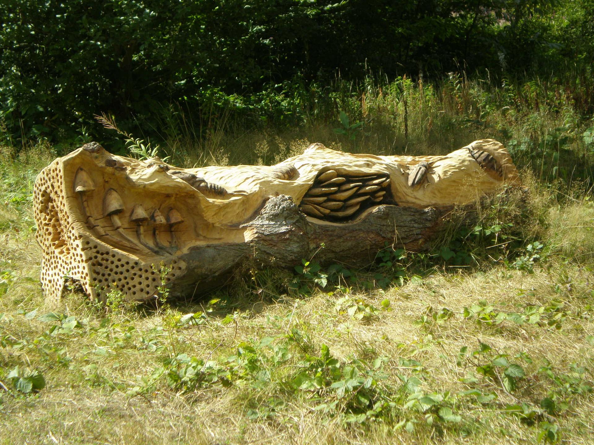
2 Living log
This sculpture, known as the Living Log, is one of four which make up a landscape trail through the Hucking Estate. On this walk, we will see three - all created by Nick Speakman and Rob Dyer. The sculptures are made from wood and over time they will weather, blending into the surrounding environment.
This log is no longer part of a tree but is becoming its own microhabitat. It is now decaying and through this process of decomposition supports many animals by providing food and shelter.
In the UK at least 2,000 species of invertebrates rely on rotting wood as part of their life cycle. An interesting example is the rhinoceros beetle. The male has a distinctive ‘horn’ on the top of its head and is glossy blue-black in colour.
The larvae depend on old trees and rotting wood to live in and feed on, particularly the common beech tree. These larvae grow into adult beetles that fly around the woods and live off tree sap. Birds, snakes and small mammals will eat these beetles and in turn support the woodland ecosystem.
Directions
Take the path to your left (from the direction you’ve come). This leads down to the old droveway through a gate. Turn right on the droveway and continue through the woods. Look out for a fenced off area on your left.
3 Droveway/Denehole
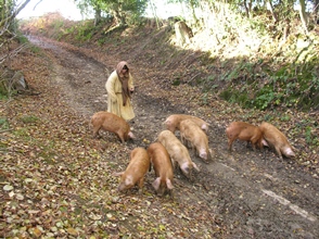
This track, known as a droveway, was trodden down and shaped by pig farmers or ‘drovers’, who used it to drive their pigs to and from pastures, known as ‘dens’. These dens were often small clearings within the woodlands for the animals to graze in. They may be the origin of local village names including Biddenden, Smarden and Tenterden.
If you look to your left you will see a fenced off area and some trees and plants. It is difficult to see what the attraction is as most of this site is underground.
During winter it is easier to see that this hollow is a chalk pit, also known as a ‘denehole’. Here, chalk was dug out (by hand) and spread on the surrounding fields to improve drainage and soil fertility. These deneholes were normally dug at a field or in woodlands, so as not to create an open mine in the middle of a productive field.
Bats such as Daubenton’s, brown long-eared and Natterer’s inhabit these deneholes now. They use the mines for winter hibernation as they favour habitats that are moderately cool and remain at a constant temperature. They are also less likely to be disturbed underground by light, noise and predators.
Directions
Turn right at the signpost ‘viewpoint’ through a gate and across a field. Keep left across the grass path until you reach the shepherd sculpture.
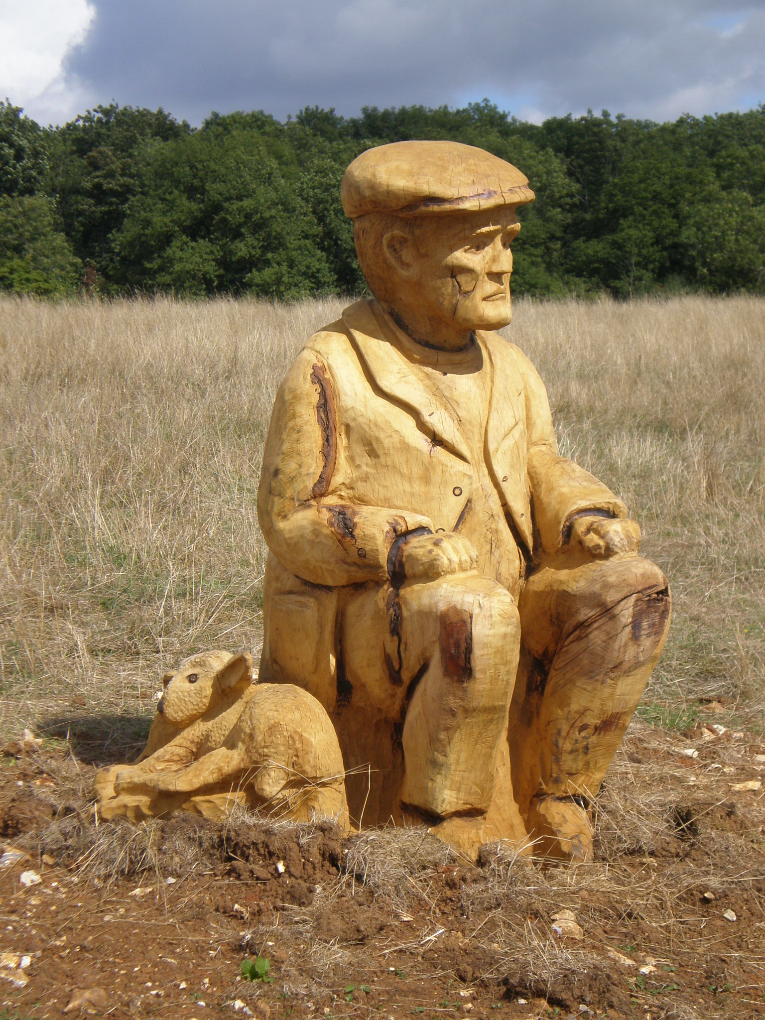
4 Shepherd statue
The carved shepherd with his lined, grimaced face represents the years of hard work invested in grazing sheep out in all weathers on the downs.
Stand next to the shepherd and follow his gaze. You are looking off the edge of the North Downs chalk ridge towards the village of Hollingbourne and beyond to Leeds Castle. Hidden in the trees below you is the North Downs Way which follows the North Downs escarpment from Farnham in Surrey through to the White Cliffs of Dover.
This field is a typical chalk grassland habitat on the edge of the escarpment. This ecosystem is under threat due to years of over grazing by sheep. Fertilisers and pesticides have also changed the nature of the soil so that traditional plants and flowers cannot grow.
In 1999 native grass seed mixtures were sown into these fields to convert them from arable land to grassland. Since then, no pesticides or fertilisers have been applied, leaving it to evolve naturally. Thirty new trees were planted in 2011 to replace trees that were lost during this intensive period of agricultural use.
Directions
Take the path to your right leading away from the shepherd. Pass through the kissing gate in the top corner of the field. Ahead of you is a single oak tree at the start of the dry valley. Walk between the tree and the fence and on your right you will see a family of wild boar statues.
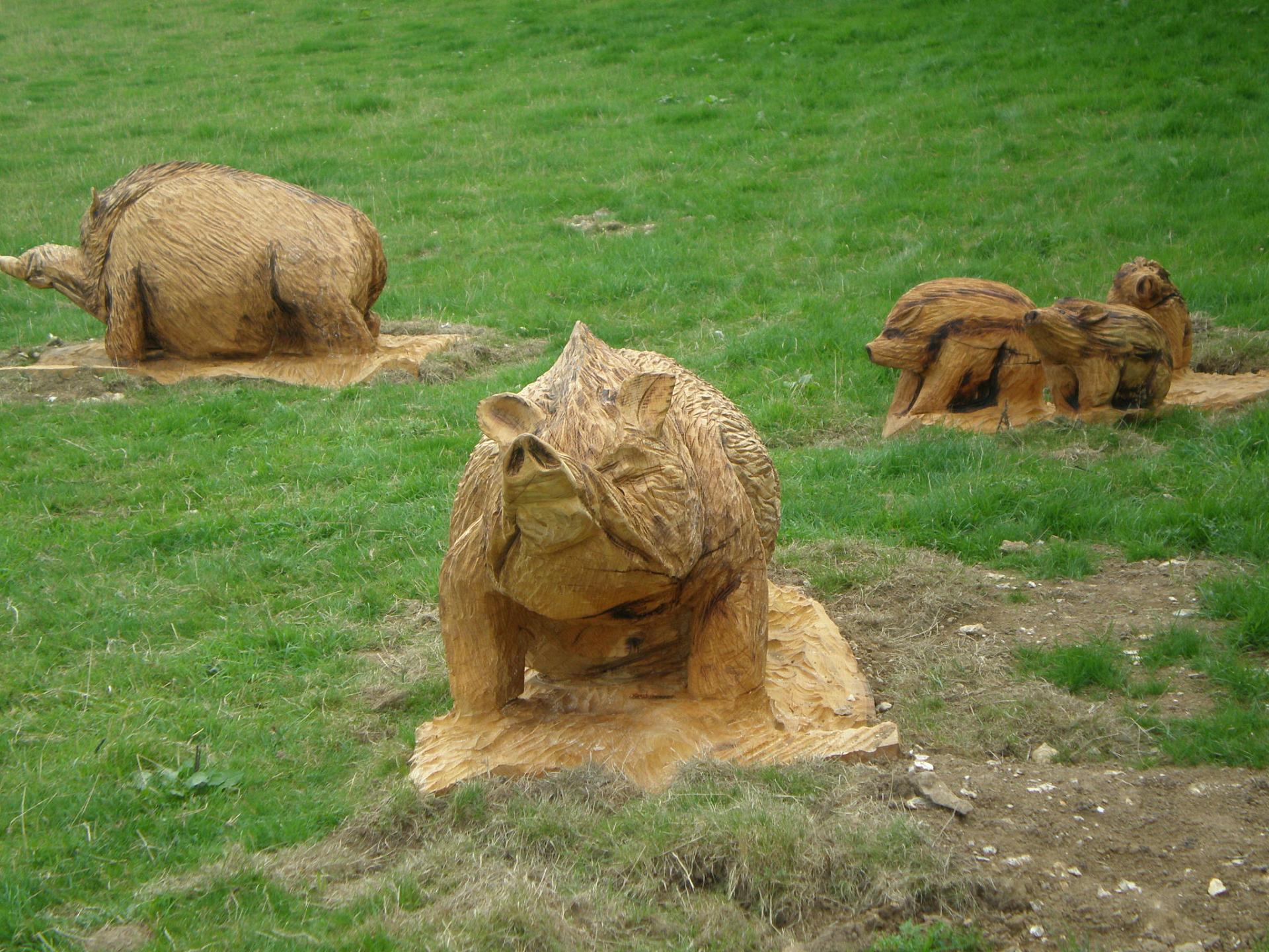
5 Wild boars
Wild boars like these used to roam the woods and grasslands of Britain until at least the seventeenth century when they were hunted to extinction.
A DEFRA (Department for Environment, Food and Rural Affairs) study in 1998 identified two species of wild boar still living wild in Britain, one on the Kent/Sussex border and one in Dorset. These populations are thought to have come from animals released back into the wild by private owners.
Wild boars are not the only animals that are now absent from this landscape. Five species of butterfly have disappeared from Kent in the last 50 years, including the pearl-bordered fritillary which vanished as recently as 2002.
Modern farming methods are chiefly to blame. Natural habitats are ploughed up for farmland and sprayed with chemicals, which stay in the soil for years, leak into nearby water sources, and are in turn absorbed by wildflowers and nearby grasses. The butterflies feed from these contaminated flowers, gradually reducing their fertility and resilience.
Don’t be alarmed, you won’t see wild boars at Hucking! These wooden statues are a link back to the droveway we saw earlier on the walk and serve as a reminder of the ancient practice of droving pigs (similar to the wild boar) through the Weald.
Directions
Continue walking in the field along the dry valley from the boars for approximately 300 metres. Leave the field through a kissing gate on the right hand side and turn immediately left onto a path parallel with the field with woodland on your right for a further 275 metres. Before the gate at the end of this path take the path to your right and walk into the woodland up a short uphill section. At the next path cross roads, go straight on and pass through a gate onto the bridleway. From the gate walk straight ahead down the slope and within 100 metres take the path to your right and follow this back to the car park keeping straight ahead at the next path intersection.to return to the car park.
Your browser is out of date, and unsupported by this website. Please upgrade to the latest version to use this website.
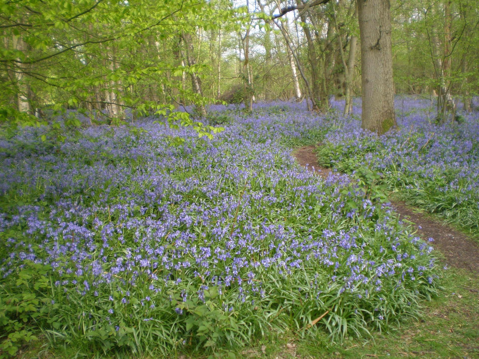
A short walk through ancient woodland near Maidstone, Kent
Just off the busy A249, not far from Maidstone, is a peaceful woodland crisscrossed with walking paths and boasting sweeping views across the North Downs.
Owned and managed by Woodland Trust, it’s one of their top 10 bluebell woods, but there’s plenty more to enjoy here all year round. This short trail introduces you to a mix of ancient and planted woodland.
Find out more about the trees around you, the woodland traditions and local heritage. As well as identifying the different species of trees, enjoy the many wildflowers, butterflies, bats and threatened bird species that call this woods their home.
Follow the trail by clicking on the map pins or downloading the guides below
Hannah Fone for writing and photographing this trail. Hannah is a walk leader with a love of the Kent countryside. Find out more about Hannah at Walk Kent
Clive Steward of Woodland Trust for script and route suggestions and photographs
Other photographs from Flickr and Wikimedia are reproduced under Creative Commons Licenses