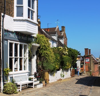
Look along Upnor High Street as it slopes gently downhill towards the river. As you continue along this traditional cobbled street, notice how well preserved it is. Most of the houses date from theseventeenth and eighteenth centuries and are made of local materials, including yellow brick and Kentish weatherboarding. The houses have been lovingly cared for and the original features like sash windows, distinctive railings and doors all add to a sense of its history.
Keep an eye out too for some of the nautical house names; The Boathouse, Keepers Cottage and at no 21 High Street a sign reading ‘Built 1665 by Lord High Admiral of the Fleet George Monck – Duke of Albemarle’. Take note too of the Tudor Rose pub with its seats made from upturned rowing boats.
When you reach the bottom of the hill, on your right see if you can spot a distinctive look-out tower facing the river. On your left, can you see the high brick walls of Upnor Castle? A castle, a lookout, grand Georgian houses, nautical house names and a pub. Now we’ve assembled the clues, we can put them together.
Upnor village grew up here because of Upnor castle and the castle was built for its strategic location on the Hoo Peninsula with access to the Thames, the Medway and London. Here we’re just downriver from Chatham where the Royal Naval dockyard and fleet were based.
Upnor Castle was built between 1560 and 1564 to defend the dockyard at Chatham from attack, particularly from the Dutch with whom we were at war. But the castle proved ineffective. In 1667 the Dutch sailed across the North Sea, into the mouth of the Thames Estuary and up the Medway to destroy the British Fleet at Chatham. The guns of Upnor Castle fired on the advancing forces but to little effect.Walk to the end of the street and stop by the bench to look across the river.
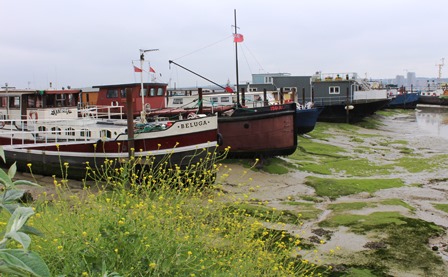
Depending on whether it’s low or high tide the view will look quite different. At low tide birds graze the mudflats and rowing boats lay beached in the saltmarsh. Across the water new glass and concrete high rises sit cheek by jowl with Victorian engineering. The long, low red brick building opposite was built as a pump house for pumping water out of Chatham’s dry dock. It’s currently being converted into a new ‘artisan’ gin distillery and bar, a sign that times are changing on Hoo.
Directions
Retrace your steps back to the top of the High Street. Turn right to follow the Saxon Shore footpath with a high wall on your right. Go down some concrete steps, turn right and walk past a boatyard to stop opposite The Ship pub.
2 The Ship pub
This is a good spot to stop and consider the changing face of the river. Gaze right from here and you can see the tall masts and cranes of a boatyard. Shiny new sailing boats sit alongside rotting barges. Fishing boats, motorboats, dredgers, tug boats and dinghies all testify to how our use of the Medway has changed from work and industry to pleasure and leisure.
Looking directly opposite, modern waterside homes line the shore. Described as a ‘strategically planned island community’ this is a brand new 150 acre development of houses which also includes a new church, school, doctor’s surgery, riverside walks, children’s play areas and public art.
Yet just two hundred years ago St Mary’s Island had a different reputation. During the Napoleonic Wars with France (1803-1815), old disused boats were moored alongside the island to hold French prisoners of war. The men who died on these prison hulks were buried on the marshes of St Mary’s Island. Besides confining POWs, the hulks were a cheaper option than building new jails, so they were used to house criminals. Charles Dickens drew on reports of convicts escaping these prison hulks for Great Expectations (1861) when Pip encounters the convict Magwitch fleeing across the North Kent marshes:
“By the light of torches, we saw the black Hulk lying out a little way from the mud of the shore, like a wicked Noah’s ark. Cribbed and barred and moored by massive rusty chains, the prison-ship seemed in my young eyes to be ironed like the prisoners."
Directions
Continue on with the river on your right. When you reach The Pier pub follow the path across a grassy area towards some boats. Stop by two stone obelisks in front of the Arethusa Venture Centre.
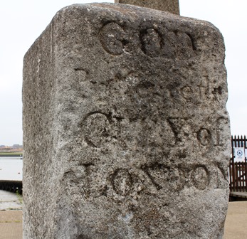
3 The London stones
These two stones may not look like much but they point to an important part in Hoo’s maritime past.
Historically fishing has been important to our island nation and the Hoo Peninsula’s location between two large river estuaries has been exploited for centuries. From as far back as the Domesday Book in 1086 individual manors on the peninsula were accorded strictly observed fishing rights. From the thirteenth century onwards the City of London was awarded the rights to fish as far as the lower reaches of the Thames and into the Medway. These boundary stones mark the southern limit of their fishing boats.
In a kind of maritime version of beating the bounds, the Lord Mayor of London made regular trips along the river including ceremonies at these stones that reinforced the boundaries of these fishing rights. Festivities often lasted for days and became merry affairs dispensing wine, beer and coins to the watching crowds.
Just past the stones look out for a fetching ship’s figurehead. It’s quite a striking model and has recently been restored. The origins of the figurehead lie in the early days of seafaring. To sailors their ship was a living thing. A figurehead was said to protect and help the ship to find its own way - and a ship could only do this if it had eyes! Female figureheads like this one baring one or both breasts were popular. Women on board ship were thought to be unlucky, but a naked woman was supposed to be able to calm a storm at sea.
Directions
The next section of the walk is only accessible at low tide. Walk along the top of the beach passing the Medway Yacht Club. Keep your eye out for a Second World War pillbox on the shore. Stop when you reach a wall of red bricks and arches on your left.
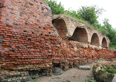
4 Cockham Wood Fort
This red brick wall on the shore of the Medway is gradually being eroded by the tide. Closer to the river’s edge see if you can spot a line of red bricks overgrown with moss. Now a rather unassuming relic, these were once an important part of the country’s defences.
This strategic location not far from the mouth of the Medway was designed to protect nearby Chatham dockyard after the devastating Dutch raid of 1667. In 1669 an artillery fort known as Cockham Wood was built here (with another across the river at Gillingham). The archways you can see are the remains of a gun platform where 44 guns pointed out into the river.
However the guns were never fired and the fort fell into disrepair.
Just before reaching the fort, did you notice the cube shaped building of brown bricks with thin, rectangular holes. Known as a pillbox (after its shape), this is another defence, this time left over from the Second World War when there was fear of a German invasion. As the land here is very low-lying, the Hoo Peninsula was identified as a possible landing place for enemy forces and was heavily militarised.
Walking along this shore today we have a different enemy. Have you noticed how much rubbish is washed up along the tide line? Torn plastic bags, drinks cans, shopping trolleys and plastic bottles all line the shore. On average it takes 450 years for a plastic bottle to decompose, that’s around five generations.
Directions
Continue ahead along the riverside path till you reach the bustling Hoo Marina.
5 Hoo marina
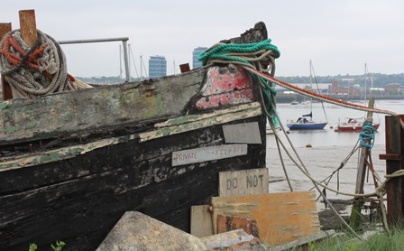
Today Hoo Marina with its cosy community of houseboats is a small floating village. Washing dries on the line, tomatoes and courgettes are grown on deck, postmen bustle along the gangways making their deliveries. As well as houseboats there are ferries, lightships (floating lighthouses), sailing boats, motorboats and barges. See how many different boats you can spot. The derelict hulks of old disused barges lie like ancient creatures beached on the shore, a mixture of an archaeological site, graveyard and wildlife habitat. But why were these boats left here to rot?
In the late nineteenth and early twentieth century this area of the Medway was a hive of industrial activity. As London became increasingly residential, many heavy and dirty industries moved out to places like the Hoo Peninsula. The peninsula was well connected to the capital via the Medway and Thames rivers, plus the local landscape was rich in raw materials including clay, chalk and gravel.
Whilst we can’t see much physical evidence of these industries today, they radically shaped the landscape. Between Hoo St Werburgh and Grain, millions of tonnes of clay were dug out by labourers called ‘muddies. Their work removed most of the saltmarsh and dramatically changed the shape of the coastline. Clay is one of the key ingredients of cement which is used to make concrete, probably Britain’s most important building material, which in turn dictates how our urban centres look today.
Clay was also used to make bricks and several brickworks developed along the river. Just a little downstream from here we’ll pass through Hoo Marina Park, an estate of prefabricated houses. The site was an old brickworks. From beside the river, bricks were transported by barge to the growing centres of London, Rochester and Chatham.
An increase in rail transport and decline in cement production meant that by the 1930s river transport on the Medway was in decline. The barges which had plied the river were abandoned and left to their fate. Today they are reminders of another era and the area’s lost industrial past.
Directions
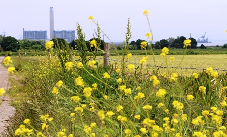
Keep following the Saxon Shore way footpath signs. Walk through Hoo Marina park an estate of prefabricated houses to emerge at a road. Follow an obvious footpath across the field towards the houses of Hoo St Werburgh and church spire. Cross the road and walk through the churchyard. Follow the footpath out the far end of the church, bear left at field junction. Emerge onto track with a sweeping view of the arable fields, power station chimney and church tower.
6 St Werthburga Church field view
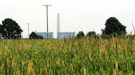
Though perhaps not a traditionally beautiful view, the vista from here sums up the complex character of the Hoo Peninsula. In this low-lying spur of land vertical structures like the chimney of Kingsnorth power station straight ahead dominate the view, and along with views of Tilbury power station on the Essex coast add to the common perception of this as an ‘industrial’ landscape. Kingsnorth is now decommissioned and being demolished.
When this power station was built here the Hoo Peninsula was undeveloped marshland. As an open, sparsely populated area with river access for deliveries and cooling water it was an ideal location.
Just beyond the power station you can see the industrial clutter of its jetties and cranes extending out into the Medway. Looking further round to the right you can see Darnet Fort on its small island. Like the Cockham Wood Fort we saw earlier it was another line of defence built to defend Chatham dockyard from attack.
Finally the tall spire of Hoo St Werburgh church reminds us that the perception of the Hoo Peninsula, as a forgotten backwater isn’t new. In 1732 the painter and engraver William Hogarth (best known for the Rake’s Progress and Gin Lane) visited the church as part of his ‘Five Day Peregrination around the Isle of Sheppey’. Hogarth intended this as a tongue in cheek ‘ungrand tour’ around the mouth of the Medway which was a butt of jokes for knowing metropolitans.
Directions
Continue ahead on the well marked track. Pause anywhere you choose between here and the end of the trail for the last stop.
7 Saxon Shore way
As you continue on the straight, obvious path back to Upnor where we started the trail you’re on a footpath known as the Saxon Shore Way. Take a look at an Ordnance Survey map and see how the path runs parallel to the shoreline. This footpath runs 163 miles from Gravesend in Kent to Hastings in East Sussex. It traces the coast of South East England as it was in Roman times around 1500 years ago.
Its name comes from a series of Roman forts that were built along the coast in the 3rd century AD to protect against Saxon invaders coming from Denmark.
The land you’re walking on and the surrounding farmland didn’t exist 1500 years ago! In fact a third of the Hoo peninsula, including the Isle of Grain wasn’t here at all. This is land that’s been reclaimed from the sea. Around the 12th century, sea walls were built and ditches and dykes dug to enclose and then drain what was seen as ‘uprofitable’ salt marsh. The land was used for new grazing pastures to help feed the growing population and enrich the local farmers.
The story of the Hoo Peninsula is a tale of fishing and farming, defence and dereliction, industry and isolation. The deep-water channel of the Medway brought prosperity but its growing industrialisation changed the shape and character of the natural saltmarsh landscape.
From Dickens to Dr Feelgood a picture has been painted of a semi-industrial backwater, just a few miles from London which until recently has been out of sight and mind. Recently identified and then rejected for a new London airport (Boris Island), with its heavy industry slowly being demolished and new towns created, what might the future hold for this spur of land caught between the Thames and the Medway?
Directions
Follow the obvious track straight ahead. Passing a farm and buildings. Keep in the same direction until the footpath becomes an alley between backs of houses. Emerging at a road of suburban houses follow the Saxon Shore Way signpost left. Follow the path downhill through woods to emerge at the London Stones. Turn right and retrace your steps back towards Upnor Castle and car park.
Your browser is out of date, and unsupported by this website. Please upgrade to the latest version to use this website.
A short walk in the North Kent Marshes that inspired Charles Dickens
Despite being just 30 miles downriver from the capital, the Hoo Peninsula is a fairly isolated place. Sandwiched between the lower reaches of the Thames and the meandering Medway, Hoo's isolated position encouraged the development of industry.
With water on either side, Hoo has long been a strategic location for defence. Today its decomissioned power stations and derelict military forts tell stories of more turbulent times.
On this short walk from the pretty village of Upnor, explore the changing face of the river and its marshlands that attracted writers like Dickens and painters including Turner and Hogarth.
Follow the trail by clicking on the map pins or downloading the guides below