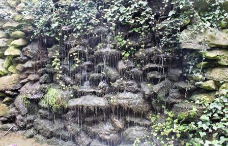
This semi-circular rock structure is a grotto. Grottoes became fashionable in the sixteenth century where they were used in many Italian and French gardens. This one is designed to look like a naturally occurring water feature, with a curtain of water dropping over the ivy-clad rocks.
Stand here and look around at the variety and landscaping of the trees and bushes. Does it look like natural woodland? This area was deliberately landscaped during the Victorian period, when Folkestone was a fashionable resort. The Victorian landscapers designed it with a variety of trees and plants, built the dripping stone grotto and altered the natural flow of St Eanswythe’s water to create an attractive riverside walk in which visitors could promenade.
As you follow the path you’ll hear and see the stream as it gently cascades over rocks. These mini weirs were deliberately added to make the course more varied, adding interest and pleasure for those who strolled alongside it. Notice how wildlife and particularly birds also use this river as a natural corridor to move along.
Keep an ear out for the sound of water falling, enjoy the effect of sun and light through trees. How do the sights and sounds of running water make you feel? Remember this feeling as we continue the trail.
Directions
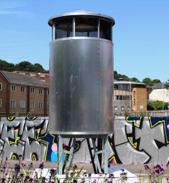
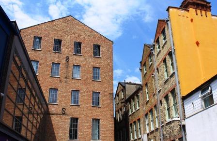
Walk alongside the stream until you emerge onto a main road (Park Farm Road). Take a close look at the steel structure on your left. Cross the road and with the 4-storey redbrick flats to your left, walk along Pavilion Road (right hand side).
2 Pavilion Road
Do you remember the steel structure we saw at the end of the last stop? If you looked closely you would have seen two water pipes joining together and disappearing under the concrete pavement. This is where two streams: St Eanswythe’s and the Pent join forces. United as a single stream, it now flows underground and out of sight behind the houses on our right. As you walk along, notice that many of these houses have below-ground basements. When the river rises these have been known to flood.
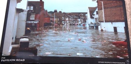
To appreciate the unseen water’s potential power, cross over to no 30 Pavilion Road and find a photo on the telegraph pole outside. It shows a picture of when the street flooded in 1996. Meanwhile, between numbers 33-35 there is a gap between the houses. Peer over the fence and you can spot the gardens behind running downhill to an area grown over with weeds. It’s under here that the Pent continues its journey below ground.
Keep an eye out too for street names. Garden Road - though now residential - is a clue to how rural this area once was. The Pent was once a fertile river valley. Before it was built over with houses, these streets were orchards, fields and gardens.
Directions
At the end of Pavilion Road turn left onto Black Bull Road. Just after the last house on the left (no.2) peer over the brown gate and you’ll see a small section of the Pent above water - a rare above-ground glimpse of the stream we’re tracking. Continue ahead and walk onto the grass verge with a water tower.
3 Junction of Foord Road and Black Bull Road
Though today it might look like a fairly ordinary junction - a mix of residential houses, verges, roads and scattered businesses - this is an important stop in our story of how Folkestone’s hidden stream has shaped the town. Take a look at the water tower. This is part of the artwork Pent Houses, created for the FolkestoneTriennial in 2014, which mark the course of the lost river. In the current climate of increased awareness about the pressures on natural resources, flowing water is once again seen as a precious asset, and in many places canals and urban waterways are being opened up and revitalised as parks or cycle paths. The presence of water increases the value of real estate, wherever in the world: this is the sly allusion made in the punning title Pent Houses
If you take a look at the Ordnance Survey map of 1921, you’ll see a ‘chalybeate spring’ marked on it. This was a water source thought to have health giving properties. Though this is a twentieth-century map, we know there was a spring here from at least the fourteenth century, and a substantial waterway flowed along this route. At this point on its course, the Pent Stream was powerful enough to support many local industries, including a water-bottling company, several mills, a brewery and a tannery. All of these required vast quantities of water. There are still clues to these industries around us if we know where to look…
Take a look at the two redbrick buildings. The one on the left is the old public swimming baths (you can still see the separate entrances for men and women). Next to it, the classical looking double-fronted building, was an important town employer. This was the Silver Springs Mineral Water Company which made soft drinks. Fittingly for our walk, the brand name of its home-made lemonade was ‘Spring Up.’
Now walk a little way down Foord Road and stop outside the Red Cow pub. Today this is an area most people bypass on their way into the town centre, but Foord was once a separate village. The Red Cow occupied an important place at the village’s heart. It’s here that several important roads converged (and still do): the old road to Canterbury, the old route to Dover and the road to the harbour. This was a well-sited spot for weary travellers to rest and water their horses.
Street names are often good geographical clues to how the landscape once looked. Foord Road comes from ‘ford’ meaning a crossing point over a river.
Directions
Continue down Foord Road passing under the viaduct. Take an immediate left and with the viaduct on your left and Bradstone Court on your right, walk almost to the end. Just before the mural, look over the wall and between the backs of the houses you can see the curving shape of the underground stream as it follows the contour of the land down to the sea.
Turn right and walk onto Bradstone Road. At the end of a row of houses on your left is a high ivy-clad wall. This would once have been ground level and Bradstone Road, the bed of a powerful river. Continue until you reach the junction of Foord Road, Dover Road and Tontine Street and stop by another silver water tower.
4 Junction of Foord Road and Tontine St
We’re standing on a traffic island at a major road junction. It’s hard to picture it now, but a bridge once stood here so people could cross what was then a substantial river. Today a water tower above ground marks the route of the unseen resource which shapes the geography of the town.
The shape of the land where we started the walk (around the junction of Foord Road and Black Bull Road) was broad, flat and open. But as the Pent Stream continued on its course to the sea the river valley it carved gradually became narrower and deeper.
Though today we’re still several yards away from the current coastline, this was where the Pent once met the sea. The estuary created by the stream, together with its tidal inlet, provided a sheltered moorage and several centuries ago this area would have thronged with boats. However over the years, the combined action of silt deposits and local currents created a shingle bar across the estuary silting up the upper reaches of the inlet (where we’re standing now). As a result, this area gradually became a stagnant marsh and a repository for rubbish.
Although the upper reaches of the inlet became unusable as a harbour, in the early seventeenth century the Pent still flowed with enough force to power several mills, including one on Foord Road South (the road next to the building with a clock on the front).
The row of red brick cottages raised above the road hold another clue to the unseen water we’re following - they’re called Spring Terrace.
Directions
Walk towards the narrow green building called The Wedge and go down the thin street between the buildings. Stop on the corner by the large, square silver building (The Quarterhouse).
5 Mill Bay
The narrow road of warehouses and industrial looking buildings we have just walked along is Mill Bay, another street name in which we can read the area’s past.
By the eighteenth century, a large mill was sited at the tidal inlet of the Pent stream. A direct route was needed to reach it from the Old High Street. Mill Bay was a new road built to link the mill with the Old High Street. If you study its shape as it narrows and curves, you’ll see it follows the contours of the river valley. Ahead, the sloping Payers Park was built on the valley side. Industries along here included a hemp-processing factory making rope used by the many boats which were moored along the banks of the river.
The water mills and the new road at Mill Bay were part of Folkestone’s growing industrialisation. The marshland which had formed in the upper reaches of the Pent Stream inlet was slowly being built over. What had been water was becoming land. Soon Mill Bay developed housing and light industry along its route and all that was left of the bay was its name.
By the time Tontine Street was built, Mill Bay was no longer an important thoroughfare and had degraded into a slum. Today though its cobbled path and attractive warehouses are a popular place to live and work.
Directions
With your back to Payers Park, walk to the left of the large silver building (the Quarterhouse) and turn right onto Tontine Street. Go to the end of the street and stop at the bottom of the Old High Street.
6 Junction of Tontine St and Tram Road
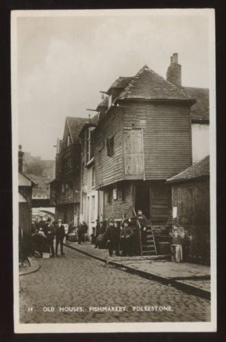
Look across the street at the area of flat land to the left - now the tourist information centre car park. It was here that the Pent and another stream named Martha’s Dyke once flowed into an area known as Old Sea Gate. This would have been a warren of ramshackle wooden houses, inns, shops, and docks housing a rowdy fishing community.
In 1998 archeologists excavated this area and found evidence for Folkestone’s medieval harbour. Deep trenches revealed timber piles and planking. These formed a retaining wall to South Street, with today’s harbour to one side and the hillside to the other. It was against this wall that ships were moored to unload or load their goods. The timbers were dated to 1625–1650.
Water however, takes as well as gives. By the mid-eighteenth century, silt deposits from the river had formed a shingle bar across the estuary, which blocked the harbour’s entrance. As the site of the harbour shifted further south and the land behind it was built over, a new one was needed. Tontine Street was built to link today’s harbour to the expanding town. The Pent stream was realigned underground through a brick culvert and it disappeared from sight.
Directions
Walk along Harbour Street toward the harbour and stop by the ice cream shop near the water fountains.
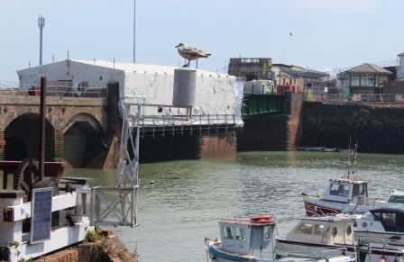
7 Folkestone Harbour
See if you can spot the silver water tower perched above the redbrick wall just behind the ice cream shop. Directly underneath it you’ll see a metal sluice gate. This is where the Pent enters the sea.
This final water tower marks the end of our trail tracing the Pent on its journey through the Foord Valley to the sea. Once a naturally meandering stream, it has been heavily modified and built over as a result of urbanisation. It may be hard to believe but the Pent is still classified as a main river by the Environment Agency, and its flows can still flooding today.
At the beginning of the trail we walked along the riverside path following the gentle course of another of Folkestone’s natural water sources - St Eanswarth’s - before it too disappeared underground. The Victorians valued the water and turned it into an attractive, playful, peaceful place in which to wander (and wonder).
It’s worth reflecting for a moment on what we lose when our streams and waterways become ‘lost’ to us and what our towns and environments might look and feel like if we brought them back.
Thanks for completing this Discovering Britain trail following the course of the Pent stream through Folkestone. While you're here you might enjoy wandering out along the Harbour Arm (straight ahead of you) for it's breathtaking views of the coastline and chance to look back at the town from another angle.
Your browser is out of date, and unsupported by this website. Please upgrade to the latest version to use this website.
Water is a source of nourishment and power. We need it to grow our food, wash our clothes and take away our waste. People settle near rivers and water sources, and Folkestone wouldn’t be here without it.
The Pent stream, an ancient watercourse flowing from the North Downs to the sea, was once vital to the town. Today its presence is barely noticed. Now hidden and built over by urbanisation, it’s deemed a threat not a life force.
This trail maps the route of this lost river in the lie of the land, street names and buildings.
It was inspired by Pent Houses, a public artwork by Diane Dever and Jonathan Wright originally exhibited as part of the Folkestone Trienniale 2014.
Follow the trail by clicking on the map pins or downloading the guide below