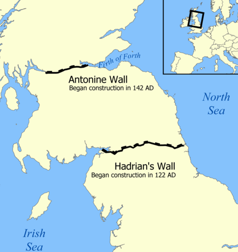
Falkirk lies on the waist of Scotland, the narrowest point between the east and west coast. In fact less than 30 miles separate the two great river estuaries of the Firth of Forth and the Firth of Clyde where the country’s two largest cities lie.
Even though it is not geographically central in Scotland, this zone is known as the Central Belt. Across this narrow strip of land run a range of routeways deliberately sited there because of Scotland’s geography.
On this walk we will explore four different connections between the two coasts of Scotland that pass through Falkirk.
The roads, railways and waterways are all quite different, as were the reasons for building them, but they share the same route and are a product of geography and landscape. We will find out why this particular route was chosen for these routeways. We will see some marvels of engineering that overcame challenges posed by natural landscape. And we will find out how old routeways have been given a new life.
This walk was created by Martin Haslett, a town and country planner. Martin: “I’ve always enjoyed travelling around Britain and discovering how places connect up with each other. For a while I regularly travelled by train between Birmingham and London. I always looked out for the points where the canal, the railway line and the motorway run alongside each other. I wondered what it was that caused engineers – over a period of 200 years – to choose the same line for their transport routes. This walk finds out about the geographical reasons why connections have taken the same course across central Scotland over nearly 2,000 years!”
From the roundabout outside the Visitor Centre, turn right and take the broad path marked ‘Antonine Wall and Union Canal’. After about 75 metres turn right and go under the canal aqueduct. Follow the main path as it turns to the left up to a signpost. Turn right on the path signed ‘Antonine Wall, Rough Castle Fort’. At the footpath junction turn right signed ‘Antonine Wall, Rough Castle Fort.’ Stop after about 700 metres just before the gate to the Antonine Wall.
2 A great empire
The first of the connections between east and west that we will explore is the oldest: a Roman wall built in the second century AD, known as the Antonine Wall.
At the time the borders of the Roman Empire stretched over 5,000 miles. It spanned England, northern Europe, along the Rhine and the Danube, through the Carpathian mountains to the Black Sea, down the Red Sea and along the edge of the Sahara Desert in North Africa.
For many years the northern boundary of Roman Britain had been Hadrian’s Wall which extended across the neck of northern England. But in 139 AD the Emperor, Antonius Pius, ordered the expansion of the empire to include southern Scotland.
Around the extremities of the empire different means were used to mark the boundary. In some places natural features such as rivers formed a protective barrier; in others defences had to be deliberately constructed. The new boundary in southern Scotland was to be marked by a new wall.
You can trace the full length of the wall on Ordnance Survey maps of central Scotland. It’s remarkable what an efficiently short route the Romans chose across their newly-conquered territory. The total length from Old Kilpatrick on the Firth of Clyde to Bo’ness on the Firth of Forth is just 38 miles. Even with modern surveying techniques it would be hard to find a better or shorter route.
The engineers planning the route needed to know the area, to be sure that each part of the wall could be properly defended, and with the lie of the land giving the advantage to the defenders. What is more, all along the course there needed to be a good supply of construction materials. These facts reveal that the Romans had a remarkable understanding of the landscape.
As we explore a short section of the wall and one of the forts we are going to discover how the Romans took advantage of the characteristics of the landscape for both construction and defence.
Go through the gate to the top of the mound from where you can look into the ditch.
3 A military zone
Before the Roman wall was built the land here was mainly pasture, small fields and woods. The wall cut straight across the land regardless of ownership and all local residents were cleared away. This whole part of Scotland became a military zone.
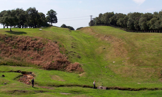
While most of Hadrian’s Wall was built from dressed stone, the new Antonine wall had a stone foundation but was built of turf. Rows of cut turf were laid to a height of three metres. Along the top there was a one and a half metre high timber walkway for the soldiers.
The first sight of the wall from here may seem a little confusing as it appears to be more of a ditch. The wall is actually on the far side of the ditch. Imagine the wooden walkway running along the top of the wall there and the structure becomes clearer.
The ditch was excavated to a depth of three or four metres. We are actually standing on the mound of material that was removed. You may think that piling up the excavated material to such a height would weaken the defensive position of the wall but attackers coming over the mound and down into the ditch had nowhere to take cover. They were easy targets for the Roman soldiers manning the wall. We will see later how the Romans adapted the landscape to weaken the position of attackers even further.
To the right is one of the best-preserved sections of the Antonine Wall. Look further right, however, to appreciate how this part of the wall’s route has been chosen to provide a good defensive position. The land to the north is a broad valley, lower than the wall and with no natural features to offer cover for attackers. The Romans would have removed any trees near the wall and the land would have been completely open. What is more, the wall is located south of the two rivers which cross Scotland at this point, themselves natural barriers to the enemy.
Walk along the mound for about 100 metres until you meet a causeway that crosses the ditch. Stop at the Historic Scotland information board.
4 A line of forts
The Romans initially planned to build forts every six miles along the Antonine Wall but this was soon revised to every two miles. So there are 19 forts along its length as well as a number of smaller fortlets. Additional forts were constructed at the two extremities of the wall where it meets the two river estuaries as these were weak points in the defensive structure.
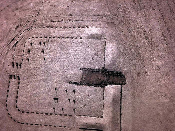
This causeway across the ditch leads into Rough Castle Fort, one of the smallest but bestpreserved of the forts along the wall.
Forts not only needed to be in good defensive positions – and we will find out more about this one’s position later – but also needed to be on land suitable for building. They required a good water supply for the troops and other local resources.
With your back to the fort information board, go to the next Historic Scotland board located about 30 metres to the left.
5 Protection by lilies
The causeway into the fort that we have just seen was a weak point in the wall’s fortifications. So the Romans incorporated additional defence features.
These are ‘lilia’ or lily pits. Roman soldiers named them after the shape of lily plants. Lilies have a central stem and wide covering leaf. These pits are a similar shape - they are around a metre deep and would have been hidden from view by a layer of brushwood. Each pit contained sharp stakes. The idea was that attackers would fall into them and get injured.
The pits were usually arranged in dense rows of 10 by 20. These ones are quite clear to see since they were excavated in 1903.
To the right is a Roman road going to the north. Although the remains are unremarkable compared to wall and fort they are important because they show how the Romans had good communications with the land to the north of the wall.
It is sometimes assumed that Hadrian’s Wall and the Antonine Wall were built as an impenetrable frontier separating the Roman Empire from barbarian lands but actually there were other reasons for their construction.
The walls helped the Romans to monitor and control the movement of people, and possibly enabled them to charge tolls. Thus the Romans had some influence and control over lands beyond the wall and there were further Roman encampments and forts further north in Scotland.
With the fort on your left go another 30 metres to the top of the earthworks overlooking a deep valley.
6 A magnificent failure?
At this point we can look down into a small valley with a stream at the bottom. From here it is clear why the Romans chose this location for their fort. It is a good defensive position, high up with a good view of the surroundings, and with a valley and water on one side.
On the other hand this point in the landscape where the valley intersects the wall would have been a weak point in the defences. It is safe to assume that there would have been extra defences at this point, either more lily pits or other strategic barriers or traps. In addition the positioning of a fort at the point of weakness meant that many fighting men were close at hand in case of attack.
Despite the careful defences it is thought that enemy attacks were a major reason for the abandonment of the wall. It had taken 12 years and a tremendous amount of earth-moving to build yet was in use for less than 20 years. In about 162 AD the Roman legions retreated south to Hadrian’s Wall. Despite the advanced military engineering, the Antonine Wall was a failure.
Optional walk extension
If you would like to explore more of the defences of the Antonine Wall go down into the valley and up the other side. You will find well preserved sections of the wall showing the rampart, ditch and the spoil bank.
At the opposite side of the valley from here there are good views back to Rough Castle Fort. Further on (towards a small car park) there are more wellpreserved sections of wall. When you are ready resume the directions below.
Retrace your steps along the top of the spoil bank and go back to the Rough Castle Fort information board. across the causeway. Turn right to cross over the wall and go into the site of Rough Castle Fort.
7 A simple plan
From here we can appreciate the size and extent of Rough Castle Fort. It is one of the smallest forts along the Antonine Wall, internally measuring only about half a hectare, although a large annexe which lies to the east is over twice the area of the fort itself.
The fort contained an administrative headquarters, a house for the commander and barracks for the troops. There was also a granary and food store, as well as a bath house.
Although the original buildings have not survived, the foundations were discovered during excavations in the twentieth century. These revealed that most of the buildings were wooden but there were also several substantial stone ones.
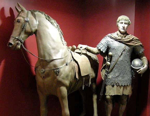
The fort would have been a very busy and noisy place in Roman times. The men garrisoned here were from the Lower Rhine. It was quite usual for troops to be drawn from different parts of the Empire rather than being locals. This was done to reduce the likelihood of the soldiers disobeying orders and siding with local people.
As was usual with Roman forts, there were four principal roads through the settlement leading directly north, south, east and west. You may be able to trace them as you look around. This very simple form of town planning was used throughout the empire and is reflected in the modern street pattern of many towns today that have Roman origins.
Continue along the top of the wall (keeping the ditch to your left). When you reach a fence, go through the gap signed ‘Falkirk Wheel and Tamfourhill’. Follow the path through the trees for about 100 metres. Take care as there is some uneven ground. Stop inside the area of woodland
8 Fast communications
Here immediately on the south side of the wall was a military road, a feature also found alongside Hadrian’s Wall.
The strategic advantages of this arrangement are clear. As well as passing messages along the wall via signal stations the road allowed for information to be moved at high speed (as fast as a horse could gallop) behind the wall. It was also an easy route for troops to move along.
The Romans had to think about this requirement when planning the route of the wall. There needed to be a good flat area on the south side for the military road right across Scotland. Their knowledge of the geography of this recently conquered area was truly remarkable!
For the next part of our walk we are moving from the ambitious military engineering of the Roman period to the remarkable civil engineering of the industrial period.
Continue along the path into an open area. Keep the woodland on your left and continue until a wider path crosses horizontally. Turn left, then almost immediately left again onto the path signed ‘Falkirk Wheel’. Keep following the signposts for the Falkirk Wheel, passing a metal fence. At the third signpost turn right following ‘Union Canal’. The canal will emerge on your left and a tunnel will be ahead. Follow the towpath towards the tunnel. Before reaching it take the path to the right that crosses over the top of the tunnel. When you have crossed over stop by the tunnel entrance on the opposite towpath.
9 A modern waterway
Over sixteen centuries on from the Romans, engineers designed canals across central Scotland to link the Firth of Forth with the Firth of Clyde. Their route was very similar to that of the Antonine Wall.
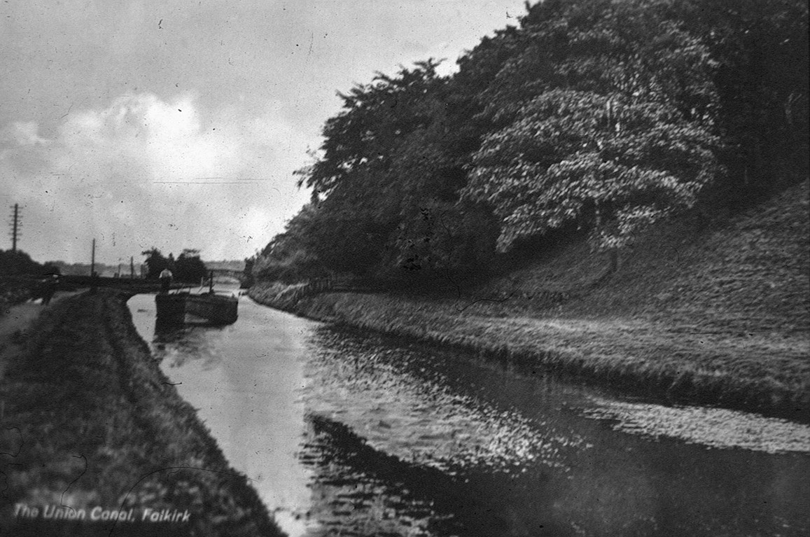
The first canal across central Scotland was the Forth and Clyde Canal, which we shall see later. This is the Union Canal which connected the Forth and Clyde Canal with Edinburgh. Its completion meant that the two principal cities of Scotland were connected by a ‘modern’ form of transport.
The main purpose of the Union Canal was to transport minerals efficiently – particularly coal and lime – from Lanarkshire to Edinburgh and thereby reduce their price.
However, this was not the only purpose. A passenger service using the Forth and Clyde Canal transfered onto the Union Canal. This allowed people to travel between Glasgow and Edinburgh in just one day, which was much faster than the overland route.
Although the passenger service was superseded by the railways pleasure tours continued until 1939, allowing people to enjoy the area’s magnificent scenery.
Union Canal at Falkirk with barge (c.1910) Reproduced courtesy of Falkirk Archives
Directions
Follow the canal towpath through Roughcastle Tunnel. At the other end continue along the towpath as it bends to the left. Stop when you reach the locks.
10 Along the contour
The main challenge faced by canal builders is constructing an entirely level waterway across the natural shape of the landscape. There are two ways to achieve this.
One solution is a ‘contour canal’ which keeps on an even contour (or elevation) across the landscape. Construction often required circuitous routes around natural obstacles, such as small hills. These detours were often uneconomical, both in building costs and the journey time for boats.
The other solution is to design straighter canals and negotiate natural obstacles using tunnels and aqueducts. To account for changes in elevation locks are built.
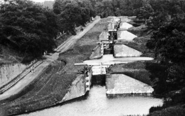
The Union Canal is a contour canal. Along its entire 31-mile length from Edinburgh to Falkirk it kept to the 73 metre contour. But when it came to Falkirk to link to the Forth and Clyde Canal, there was a problem. The two canals were built with a considerable difference in elevation - 34 metres.
Originally a flight of 11 locks were built at Camelon, just over a mile east of here. They raised and lowered boats between the two canals. The locks we can see here are replacements. The original locks at Camelon were in use until the early twentieth century.
It took boats the best part of a day to go through all 11 locks. The locks also used a tremendous amount of water - 3,500 tonnes for every trip. With the locks consuming time and water another solution was needed. We will find out more about the transition between the two canals later in the walk.
Junction Locks (c.1930) Reproduced courtesy of Falkirk Archives
Directions
Retrace your steps a little way to the sharp bend in the canal corner before the tunnel.
11 A great restoration
The Forth and Clyde Canal opened in 1790 and the Union Canal in 1822. Both were initially very successful. The coming of the railways was a setback but the two canals remained open until the First World War when Grangemouth Docks, the link into the Firth of Forth, was closed for security reasons.
After the war, both canals went into decline and little care was taken to keep them open: roads, pipelines and motorways were built across their paths. Navigating the canals became impossible. The flight of locks connecting them was closed and for decades they lay abandoned.
Then during the 1970s some enthusiasts started to carry out restoration work. British Waterways, which owned the network, began to realise that the canals had leisure potential. However, there was not enough money for a full-scale restoration until the closing years of the century, when the Millennium Commission and other bodies were able to fund the work.
Years of neglect meant that there were many difficulties restoring the two canals. There were 32 places where they had been blocked and most of the locks, bridges and aqueducts needed repair. The biggest problem though was the lost link between the two canals: the flight of locks at Camelon could not be restored.
So the decision was taken to link the canals in an ambitious and totally novel way - the Falkirk Wheel. We will explore the Wheel itself a little later.
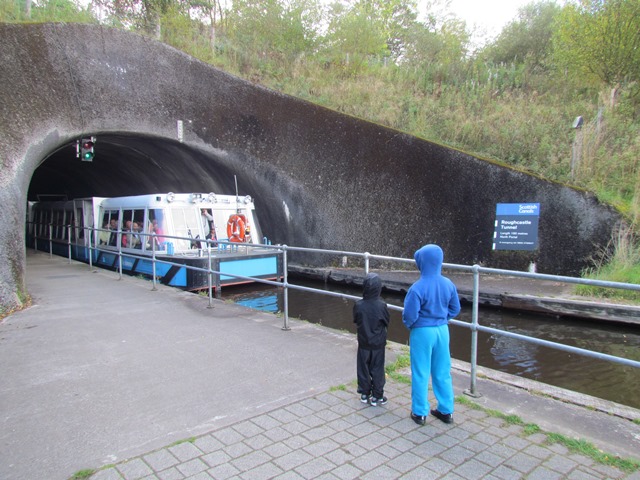
As part of the scheme a new stretch of the Union Canal was built from the old terminus, including this elevated section to the top of the Wheel. This new section includes the Roughcastle Tunnel. Built under the Antonine Wall, it was the first new canal tunnel constructed in Britain for over 100 years.
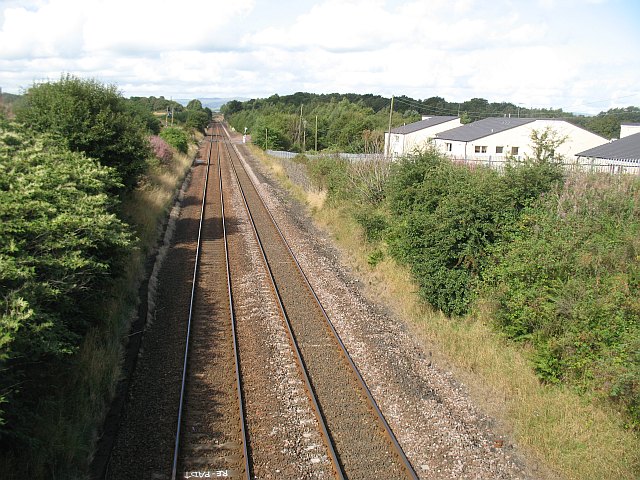
The tunnel also passes under one of the railway lines that run across Scotland’s Central Belt. Above is the Edinburgh and Glasgow Railway, the first line to be built through Falkirk. It opened in 1842.
Look on a map to trace the route of the line from Edinburgh to Falkirk. You will find that it runs very close to the Union Canal in many places. The railway surveyors were driven by the same factors as the canal surveyors a generation earlier.
Trains run faster on straight, flat routes with just a few gentle gradients. So the surveyors wanted to find a route that achieved the best balance between distance and elevation change. At the same time they wanted to minimise the expense of building tunnels, cuttings and viaducts. Railway technology and advances in engineering, however, meant that the line did not have to follow the contour quite as closely and some of the major detours of the canal are avoided.
From Falkirk westwards to Glasgow the railway closely follows the route of the Forth and Clyde Canal. It enters Glasgow just a little to the south of the canal’s route.
The Edinburgh and Glasgow Railway cut the journey time from one day on the canals to just 2½ hours by train. Today there are four railway lines running between Edinburgh and Glasgow. This remains the main one as it is the shortest and quickest, with a journey time now at just under an hour.
Return through Roughcastle Tunnel. Keep the Wheel to your left (we will see it in due course) and follow the path downhill to the Visitor Centre. Keep the Visitor Centre on your left and follow the path to the right for the Forth and Clyde Canal. Stop halfway over the footbridge over the canal.
13 A sea-going canal
We have already heard something about the Forth and Clyde Canal which, as its name suggests, connects central Scotland’s two main river estuaries. This 36 mile long waterway passes through 40 locks on its route across the country.
Throughout its route the canal’s path is remarkably close to the Antonine Wall. The canal connects with the Firth of Forth at Grangemouth, about six miles north of the termination of the Wall. It then runs westward across central Scotland, following the wall’s route closely as far as Glasgow where it diverts into the city.
Further west the canal rejoins the route of the wall. The two reach the estuary of the River Clyde within 900 metres of each other at Bowling. In fact the building work for the canal uncovered a number of Roman artefacts that were donated to the University of Glasgow Museum.
You will notice that the canal is wide by British standards. It was wide enough to allow tall-masted ships and then steam boats to travel from coast to coast and on into the sea. The canal’s width meant there was no need to move cargo from inland to sea-going vessels. This vastly increased Glasgow’s export opportunities. Glasgow’s manufactured goods, and whisky from the Western Isles, were transported into northern Europe and the Baltic countries. The canal is one of the main features that contributed to Glasgow’s phenomenal expansion during Victorian times.
Before continuing the walk do take the opportunity to cross the bridge and walk a little way along the towpath. Then you can fully appreciate the engineering work involved in constructing a canal of this size.
From the footbridge retrace your steps towards the Visitor Centre. Before you reach it, turn right through a set of gates. Cross the pedestrian area towards the lock where the Forth and Clyde Canal connects to the Falkirk Wheel basin. Go over the lock and follow the path as it bears left around the Falkirk Wheel basin. Stop near the Water Park for a good view of the Wheel.
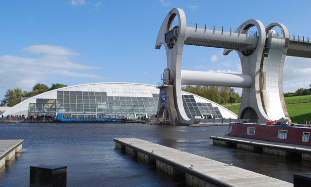
14 A magnificent rebirth
As we discovered earlier, the Forth and Clyde Canal and the Union Canal used to be connected at Falkirk by a course of 11 locks. These were abandoned in 1933 and subsequently built over. So when the restoration of the canal was proposed a new plan was needed to join two canals built at different levels.
Now we can consider the magnificent solution: the Falkirk Wheel. The Wheel is a mechanised boat lift which carries boats from one canal to the other. It was built on the site of an old tar works and, as we saw earlier, a new section of the Union Canal was constructed to meet it, including locks and a tunnel.
The Falkirk Wheel is the only rotating boat lift of its kind in the world and one of only two working boat lifts in Britain. The other one is the Victorian Anderton Boat Lift in Cheshire.
Many designs for a mechanised boat lift were considered. Eventually a wheel-shaped solution was agreed and then additional design work was undertaken to ensure that what we see today is not only an engineering triumph but also an artistic success. The wheel takes the shape of a Celticinspired, double-headed axe. The whole project cost £20 million to build and was opened by Her Majesty the Queen in 2002.
Most contemporary work on canals restores technology and infrastructure which is up to 200 years old. The Falkirk Wheel is very unusual in using modern technology to solve historic canal navigation issues.
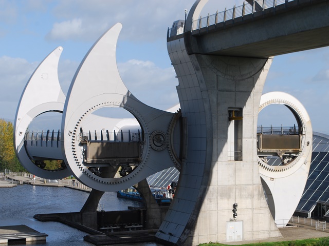
The wheel uses two giant gondolas, which contain water troughs that hold the boats. Boats coming from the Union Canal emerge from the new tunnel, then cross a 104-metre long aqueduct which runs directly into the wheel’s upper gondola.
The gates are sealed and computer-controlled motors lower the gondola the 25-metre difference in the levels. The gondola stops at a dry well alongside the lower basin. The gates are then opened and the boat has just one lock to go through to enter the Forth and Clyde Canal. The process is reversed for boats travelling the other way.
The Falkirk Wheel is remarkable for its engineering simplicity. It doesn’t use any water and takes just five minutes to make the transfer. This is a stark contrast to the amounts of time and water used in the original flight of locks.
The Wheel also uses very little electricity. Each boat transfer uses 1½ kWh (kilowatt-hours) – about the same as boiling 8 kitchen kettles! This is mainly because the Wheel was designed following Archimedes’ Principle. Archimedes was an Ancient Greek physicist and mathematician. He discovered that any object that floats displaces its own weight of fluid. A boat displaces its own weight of water. This means there is always a balance between the upper and lower gondolas - the two gondolas always have an equal weight, whether or not they contain a boat.
Retrace your steps around the basin towards the Visitor Centre. Stop by the sculpture of two horse heads known as The Kelpies.
16 Watery rebirth
Some people would say that spending £20 million on restoring a few bits of outdated canals was a complete waste of money but there’s much more to it than that. All along the canal the local economy has been boosted.
You only have to look here at the Visitor Centre to see how many people are using the restaurant and making purchases in the shop. The two canals have an estimated 20 million visitors a year, comprising daytrippers as well as those perhaps hiring a canal boat for a week’s holiday.
Visitors from outside the area tend to stay in local hotels or bed and breakfasts, and they use local restaurants, all of which brings money into the local economy.
But the impact has been much wider. The canals run through some of the most deprived parts of Scotland and the canal restoration has been a catalyst for wider regeneration and investment.
At the eastern end of the Union Canal where there once were derelict factories and warehouses, there is now a popular canalside venue with shops, restaurants, pubs and offices. At the western end in Clydebank there is a new shopping centre adjoining the canal and several new marinas have been built in between.
There has already been a lot of regeneration work in another part of Falkirk. A 350 hectare area of derelict land is being transformed into a unique outdoor greenspace thanks to a £25 million grant from the Big Lottery.
The Helix is a ‘Living Landmark’ designed to connect the 16 communities on its periphery and provide a space to share and enjoy. But it’s not only for locals. It is hoped it will become a worldclass visitor destination.
At the centrepiece of the project are ‘The Kelpies’, two 30 metre high sculptures of horse heads. ’Kelpies’ are mythical Scottish water horses in Celtic folklore. The sculptures can be seen from the M9 motorway about one mile northeast of Falkirk. Adjoining them is a short new section of the Forth and Clyde Canal, which has been built to create a link to a new sea lock on the River Carron which leads out into the Firth of Forth.
The Kelpies have become a major tourist attraction in their own right. There is often a scale model of them here outside the Falkirk Wheel Visitor Centre - although these go on international tours to promote Scotland. In summer 2014 for example they were in New York.
You might not see the model Kelpies here today but you should definitely see how restoring the canal has had a dramatic effect in the wider area.
A connection across Scotland that we have not yet considered is by road. The first planned road across the country was the military road alongside the Antonine Wall that we heard about earlier.
In modern times the major connection across Scotland is the M8 from Edinburgh to Glasgow. Look on a map and you will see that this is the first connection which does not follow the historic cross-country route that we have explored during this walk.
There are two reasons for this. First, improved engineering means that a road can be routed exactly where we want it, without the lie of the land being of too much concern. The M8 leaves Edinburgh along much the same route as the Union Canal. But it then follows a course through the hills of central Scotland, with cuttings and embankments to make a more level route.
The second reason is related to the modern geography of Scotland. The places which need to be connected today are the major cities rather than ports and docks along the river estuaries. So the modern road network reflects this.
There is, however, a postscript to this story. The most recent major motorway to be constructed is the M80 which connects Glasgow with the north and east, running just to the north of here. This road, with a few allowances for modern technology, broadly follows that of the Forth and Clyde Canal and the Antonine Wall.
What a tribute that is to those Roman engineers nearly of 2,000 years ago!
Throughout the walk we have explored how this part of Central Scotland contains several routeways that have run or been linked together over the centuries.
We discovered how the Romans chose Falkirk as the location for a defensive wall. We have seen how two canals pass through the landscape and the effects of their closure and reopening. We have also seen how railways and roads pass through Falkirk with close proximity to the older routeways.
The reasons for building these routeways have changed as much as the methods of travel. They have been built for defence, communication, trade, industry, leisure and tourism. But still the route for linking the two coasts of Scotland remains much the same.
They are all based on the same principle of geography. Scotland is remarkably narrow across the Central Belt, with little more than 30 miles separating the great river estuaries of the Forth and the Clyde. Falkirk’s routeways have stemmed from this unique natural location. As a result, this short walk allows us to travel through 2,000 years of transport development.
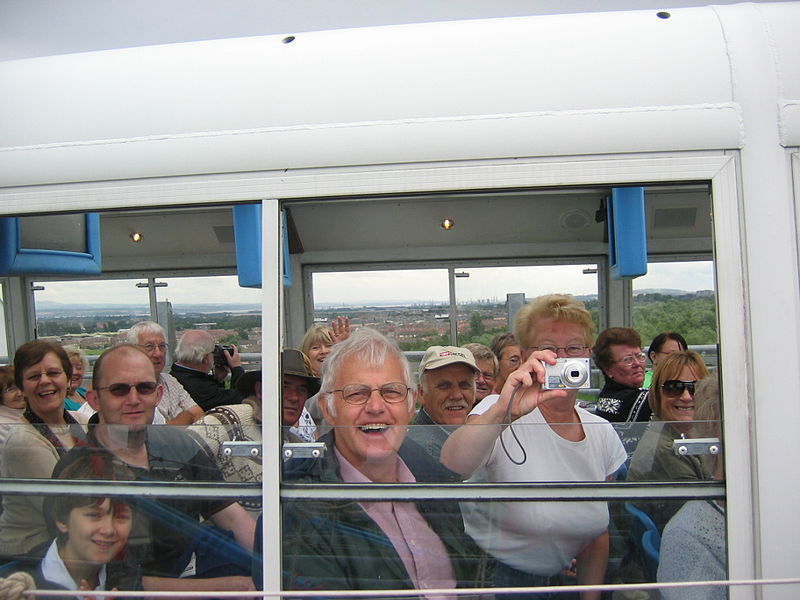
If you haven’t already done so, do explore the Visitor Centre. We highly recommend booking a boat trip so that you can experience travelling through the Falkirk Wheel.
Your browser is out of date, and unsupported by this website. Please upgrade to the latest version to use this website.
Scotland’s largest cities, Glasgow and Edinburgh, are on opposite sides of the country. They are connected by various routes across the ‘Central Belt’.
These routes are all different and so were the reasons for building them - but many pass through the town of Falkirk. This walk explores why.
Marvel at the skill of Roman surveyors who built the Antonine Wall. Find out why two canals snake across the landscape here. Discover why so many railways and roads run via Falkirk.
Also see how engineers have transformed old routes in new ways, including the remarkable Falkirk Wheel.
Follow the walk by clicking on the map pins or downloading the guides below
 Martin Haslett.jpg)
 Martin Haslett.jpg)
 Martin Haslett.jpg)
 Martin Haslett.jpg)
 Martin Haslett.jpg)