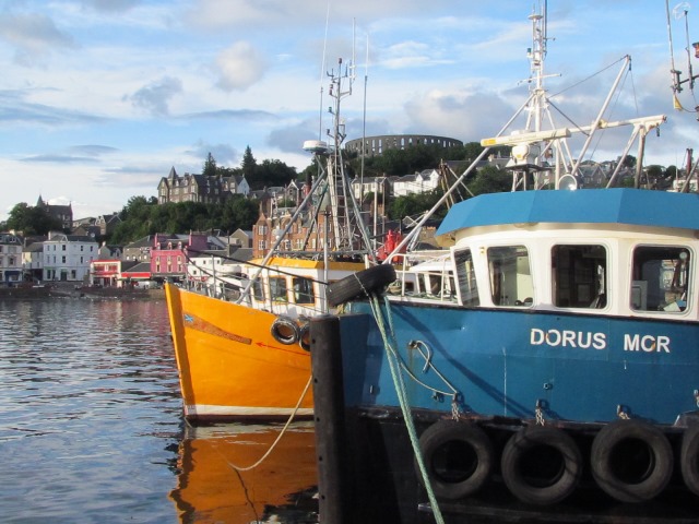
We begin where most people first encounter Oban, the South Pier. This is where many visitors arrive and depart by rail, road or ferry.
Oban’s name is from the Gaelic for ‘little bay’. Look along the horseshoe-shaped coastline from here and it’s easy to see why. The town’s natural bay is also a clue to its first fortunes.
Oban originated as a fishing village. Its location, facing the Atlantic but sheltered by the Hebrides islands, is the perfect habitat for all sorts of fish - and a safe place to catch them. Oban’s diverse fish stocks led to Britain’s first mussel farm being established 3 miles away at Loch Etive.
Turn towards the ferry terminal and look at the colourful boats and restaurants on the quayside. Oban brands itself as the Seafood Capital of Scotland. A variety of species live in the nearby waters, especially shellfish. Catches and menus change daily.
Now notice the ferry terminal looming beyond. Today ferries literally overshadow Oban’s fishing trade. Tourism has become is the town’s major source of income. This began in Victorian times when touring the Scottish islands became a fashionable pastime.
Oban’s location and natural harbour made the town the ideal base to explore Hebrides. Steamers stopped here on routes between Glasgow and Inverness. Sea travel has grown here ever since. The ‘little bay’ is now a large visitor port.
Around 8,500 people live in Oban but in the summer this figure can explode to 25,000 with beds, dinner tables and ferry tickets all proving hard to find. Many people travel through the town to islands including Mull, Coll, Barra and Colonsay.
With the road on your right follow the coastal wall towards the town centre. Take time to enjoy the views across the bay. Follow the wall until it bends sharply left. When it does this, turn with your back to the water and look down Stafford Street, a cul-de-sac beyond the traffic islands with a large stone structure on the horizon.
2 Oban Distillery and McCaig’s Tower
From here we can see two of Oban’s landmarks, the whisky distillery and McCaig’s Tower. Oban Distillery is on the right of the street with a tall chimney while McCaig’s Tower stands on the horizon. They both developed because of the town’s access to water and stone.
The distillery was founded in 1794 and is credited with the town’s first expansion from a fishing village. Whisky has been distilled in Scotland for centuries, largely thanks to the climate. Whisky’s name comes from ‘uisge beatha’, the Gaelic for ‘water of life’. It was first distilled on monasteries as a way to use up rain-soaked barley.
Distilling is a process that heats and cools the liquidised barley or malt to extract alcohol. Water is a vital base ingredient in distilling, and for centuries the grains were ground using water-powered mills. As a result, most Scottish distilleries are on coasts, islands or rivers.
McCaig’s Tower meanwhile was created because of another local resource - stone. It looks like a Roman amphitheatre but it was actually built in the late nineteenth century by a local businessman, John Stuart McCaig.
Widely called McCaig’s Folly, he planned it to be a memorial to his family. McCaig hoped that the project would also boost the local economy, by keeping the town’s stonemasons steadily employed during the winter.
The Distillery and the Tower are both popular visitor attractions. And both grew out of Oban’s natural resources. So besides its location, Oban’s landscape encouraged tourism to flourish. At the next couple of stops we will explore how this landscape was created.
Turn back around so that the wall is on your left again. Follow it past a pair of red-roofed seafood restaurants and stop at the square pier beyond. There may be large ships berthed here. Find a good view towards the island on the horizon.
3 View of Kerrera
We are now on the North Pier. Take a moment to see how many types of boats you can spot. Visiting cruise liners often dock here on tours round the Scottish coast.Smaller boats offer sea fishing and wildlife spotting trips for tourists. Others take people to the island on the horizon.
This is Kerrera, one of 79 islands that make up the Inner Hebrides. Kerrera has an important effect on Oban. It protects Oban bay from extreme weather by bearing the brunt of Atlantic storms. This makes the water between Kerrera and Oban very calm, creating a safe harbour.
These conditions are ideal for wildlife. If the tide is in, look for sunbathing jellyfish near the pier wall. If the tide is turning, see if you can spot seabirds including oystercatchers, black guillemots and little ringed plovers.
Looking across to Kerrera, you may be able to see another lager island beyond it. This is Mull, the fourth-largest island off mainland Britain. Can you name the three largest? *
Incredibly the islands that create Oban’s calm waters have fiery and dramatic origins. Mull, Kerrera and many other Hebrides islands were formed by ancient volcanos in the North Atlantic. Much of the land we can see from here was spewed into the ocean 400 to 50 million years ago by huge volcanic eruptions.
This activity shaped Oban’s coastline. Parts of the bay formed when pieces of lava cooled and fused together. If the tide is out, look for a wide variety of rocks on the beach in many complex shapes - from jagged black heaps to flat grey squares.
But besides volcanic heat Oban’s landscape was also shaped by something much colder. We will see clues at the next stop.
* The three largest islands off the British mainland are - 1) Lewis and Harris, 2) Skye, and 3) Shetland
Turn right and make your way around the red-roofed buildings. Carefully continue through a car park then turn left to re-join the coastal wall. Follow the wall until you reach a large roundabout with a grassy area on the right and two large churches ahead.
4 View of the South Pier from the A85 roundabout
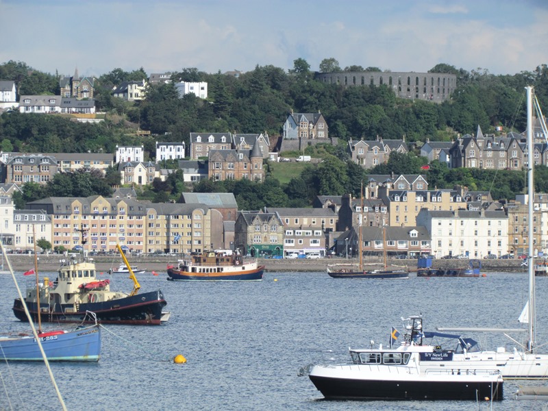
A roundabout might seem a strange place to linger but this spot offers us a view into Oban’s past. Facing Kerrera, turn left towards the South Pier. Notice the ferry terminal is dwarfed by steep wooded hills to the right.
Now slowly turn left until you are facing the roundabout. You should see a bank of tree-lined hills behind the houses. Also notice how the road from the roundabout climbs upwards.
The town of Oban sits on a step, at the foot of steep cliffs but above the sea level. The step is a feature known as a 'raised beach'. It was cut into the rock by the sea, when water levels were much higher.
After volcanoes shaped islands like Kerrera and Oban’s coast, the Earth went through a series of Ice Ages. Starting 2.5 million years ago the planet’s temperature dropped and vast areas were covered in huge sheets of ice. In Britain they spanned from Scotland to the northern edges of London.
In places the ice was nearly a mile thick! The ice was very heavy and pressed the land underneath downwards, until areas of land were partly submerged underwater.
From around 12,000 years ago the Earth slowly warmed up again and melt-water re-shaped the land. The most dramatic change though was that the pressure and weight of the ice was reduced. As a result, whole sections of land emerged from underwater even as the sea-level began to rise.
This process is called ‘isostatic rebound’. Imagine a glass of water with an ice cube in it. If you press the ice cube with your finger, it will sink downwards. As soon as you take your finger away, the ice will spring back to the surface. That is very a simplified version of what happened to the land here.
The raised beach Oban sits upon and the large cliffs behind the town both emerged like this. The shape of the land we can see from here is the remains of the former shore line, now some distance from the sea and no longer battered by waves.
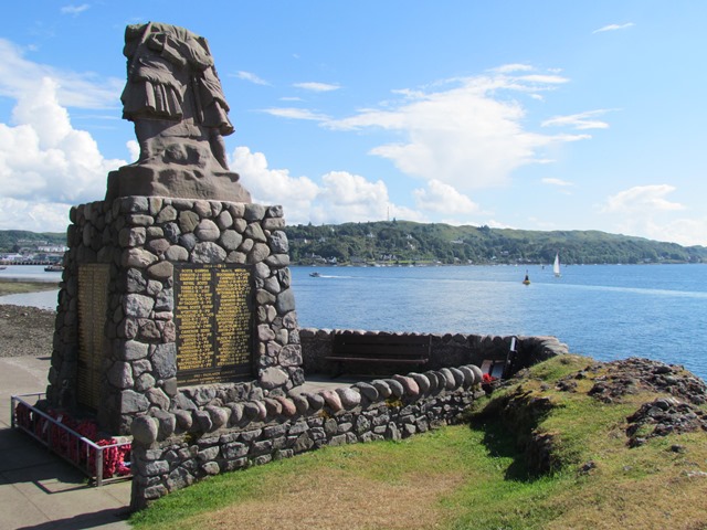
Continue along the coast path past the two churches. Keep going up to a stone memorial enclosed by a small wall. There is a large egg-shaped rock to the right of it. Pause here a moment.
5 Oban War Memorial
Take a moment to stop at this memorial, dedicated to local men who died in the First World War. Notice the outline of the three statues on the top. They deliberately mirror the shape of the large rock beside the road.
But what is this rock, about 4 metres high, doing here? The answer comes back to the melting ice. This rock was carried downhill by melting water during the end of the Ice Age. Rocks like this are called ‘glacial erratics’
As the ice melted, rocks like this were washed away from their place of origin to somewhere completely different. Some rocks were carried like this hundreds of miles. Keep your eyes peeled and they become easy to spot, as they don’t match other rocks in the area (sometimes strikingly so).
Glacial erratics are full of clues to an area’s past. They can show how much ice and water there was and the direction it must have flowed in. This one also provides insight into the first people to settle in Oban.
Look very carefully and you might be able to see curves cut into the stone. These are ‘cup marks’, engravings created by people with sharp tools. Marks like these have been found throughout western Scotland but also in north Wales, Yorkshire and Northumberland.
Their origins are unknown. Different theories suggest they are decorative artworks, early maps or tool sharpeners. The ones on this stone have been dated to the Mesolithic Period some 5,000 years ago. Tools and bones from this era have been found in caves along Oban’s coast.
Pass the memorial and continue onto the strip of grass beyond it. At the lamppost the path joins the road. Carefully cross the road and go through a set of metal gates by a white house. Follow the straight path gradually uphill, with the sea on your left and trees on your right. Stop when you reach a tall rock standing to the left of the path.
6 The Dog Stone
This large rock is called the Dog Stone. Its strange name comes from legends about a giant called Ossian who used to go hunting in the Hebrides. This rock was where Ossian tied his dog, Bran. While Ossian was away Bran would strain at his leash, creating the groove we can see near the base.
The actual story of the Dog Stone is arguably just as spectacular. This rock is a coastal feature known as a 'sea stack'. Sea stacks are created by the power of the sea’s waves. Waves wash at the bottom of cliffs and slowly break down the rock in a process called erosion. This is why the bottom of the Dog Stone is grooved.
Enough erosion will eventually create a hole in the base of the rock, which may wear away further to create a cave.
Where a coastline is rugged and a cave forms on a headland, waves will create a hole right through the cliff - like an arch-shaped doorway in the sea.
These arches often collapse over time, leaving behind an offshore column of rock. This is how the Dog Stone formed. But look where it is. Why is a sea stack standing inland, about 20 feet above the sea?
The answer is due to ice again. The land we are on now was once the edge of the coastline. After the ice melted this part of the land gradually rose up, carrying the Dog Stone with it.
This remarkable rock is our final stop. Although many people pass through Oban on their way to other places, it is worth remembering how and why. This town became a travel route thanks to a spectacular chain of natural events.
By following in the footsteps of mythical giants we have explored a coastline shaped by volcanoes and ice. We discovered how the results allowed Oban to develop, from access to stone and water to protection by offshore islands.
These dramatic ancient factors helped create today’s scenic town. Long before tourism took off, Oban had already been on a journey of its own.
To return to the South Pier you can retrace your way along the coastal path.
Alternatively you may want to continue past the Dog Stone to visit Dunollie Castle and museum. To do this, continue along the path. When you reach the end of the field take the path curving left towards a small road. The entrance to Dunollie will be on the other side of this road.
Your browser is out of date, and unsupported by this website. Please upgrade to the latest version to use this website.
Postcard of Oban bay c.1900, Wikimedia Commons (CCL)
Oban trail
A short walk along the coast of Oban
Located halfway along Scotland’s west coast, Oban is often called ‘the Gateway to the Isles’. In summer months this small town’s population explodes as tourists pass through on ferries and flights to the Hebrides and Highlands.
There is another story though beyond travel and transience. This trail uncovers Oban’s dramatic origins.
Find out how fire, ice and water created a unique landscape and discover for yourself why Oban is much more than just a route to other places.
Follow the trail by clicking on the map pins or downloading the guides below
“We had a good day and a fine passage, and in the evening landed at Oban... it was comfortable to be now on the main land.” - James Boswell, The Journal of a Tour to the Hebrides
 Now notice the ferry terminal looming beyond. Today ferries literally overshadow Oban’s fishing trade. Tourism has become is the town’s major source of income. This began in Victorian times when touring the Scottish islands became a fashionable pastime.
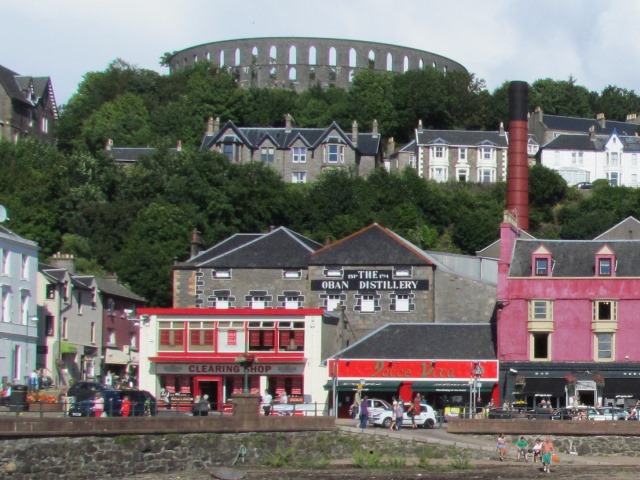
") The distillery was founded in 1794 and is credited with the town’s first expansion from a fishing village. Whisky has been distilled in Scotland for centuries, largely thanks to the climate. Whisky’s name comes from ‘uisge beatha’, the Gaelic for ‘water of life’. It was first distilled on monasteries as a way to use up rain-soaked barley.
The distillery was founded in 1794 and is credited with the town’s first expansion from a fishing village. Whisky has been distilled in Scotland for centuries, largely thanks to the climate. Whisky’s name comes from ‘uisge beatha’, the Gaelic for ‘water of life’. It was first distilled on monasteries as a way to use up rain-soaked barley.") Widely called McCaig’s Folly, he planned it to be a memorial to his family. McCaig hoped that the project would also boost the local economy, by keeping the town’s stonemasons steadily employed during the winter.
Widely called McCaig’s Folly, he planned it to be a memorial to his family. McCaig hoped that the project would also boost the local economy, by keeping the town’s stonemasons steadily employed during the winter.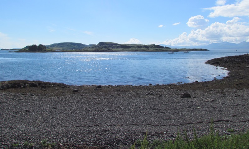


 Glacial erratics are full of clues to an area’s past. They can show how much ice and water there was and the direction it must have flowed in. This one also provides insight into the first people to settle in Oban.
") Where a coastline is rugged and a cave forms on a headland, waves will create a hole right through the cliff - like an arch-shaped doorway in the sea.
Where a coastline is rugged and a cave forms on a headland, waves will create a hole right through the cliff - like an arch-shaped doorway in the sea. 
