Welcome to this Discovering Britain walk in the north western corner of the Lake District National Park. Following lakeshore, riverside and steep mountain paths, this spectacular walk provides magnificent views of mountains, waterfalls, lakes, and valleys.
This walk, created by geographer Katy Moore, explores 490 million years of landscape formation and three centuries of landscape art in the Borrowdale Valley.
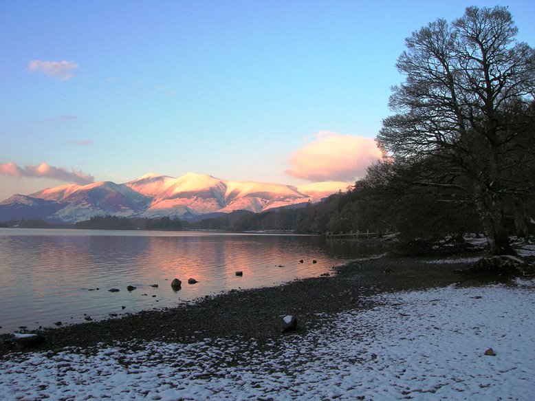
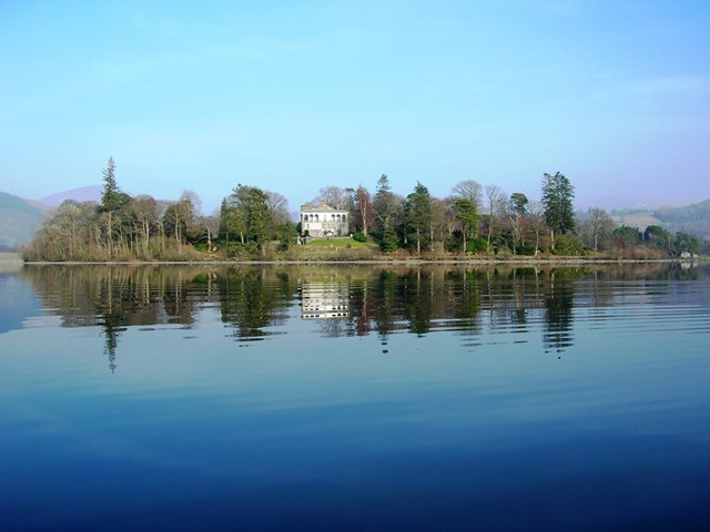
Let’s begin with an example. Stand on the terrace of Derwentwater Hostel (Barrow House) in front of the pale blue double doors. In the foreground is the hostel lawn and beyond it Lake Derwent Water. Look right to the top of Derwent Water where the town of Keswick is backed by high mountains. This is the northern end of the lake at the top of the route map.
Now try and spot Derwent Island, identifiable by its grand house. The house is partly concealed by trees and the island appears to merge into the mainland but you can use the map to help you locate it. Later in the walk we will see the island from a much greater height and the geography of the lake will become more obvious.
What do you think of this view? Do you think it would make a good subject for a picture? Which features particularly attract your attention?
In viewing the landscape carefully and critically, seeking beauty and pleasure, we are following a long tradition which began in the mid eighteenth century with William Gilpin. He was one of the first people to write about the aesthetic qualities of the Lake District.
A Cumbrian-born cleric, artist, author and school master, Gilpin travelled to Borrowdale in 1768, searching for landscapes that matched his definition of the picturesque: ‘that particular kind of beauty, which is agreeable in a picture’
Gilpin’s writings, including detailed principles of picturesque beauty, were based on his knowledge of landscape painting and they helped to popularise the Lake District. His observations went on to influence Romantic artists and poets like JMW Turner, Samuel Taylor Coleridge, Robert Southey and Thomas Gray, who all followed in his footsteps.
Before Gilpin it was unusual to look for aesthetic qualities in the landscape. Subjects and scenes for paintings were chosen for their morality or utility rather than their beauty or picturesque qualities.
Gilpin and the Romantic artists and writers rejected these earlier ideals of reason and order; instead they preferred quaint roughness to Classical formality. They sought out ‘picturesque’ scenes of irregularity, ruin, decay and rusticity, and valued a closer relationship to nature. They also sought the thrill of ‘the Sublime’, those dramatic feelings that rugged mountains and torrential waterfalls could provoke in the viewer. The Lake District was the perfect source of inspiration for this Romantic frame of mind.
In 1768 (the same year as Gilpin’s first visit) a very different character visited Borrowdale. Joseph Pocklington was an eccentric country squire whose first visit to the Lake District inspired him to buy Derwent Island (then known as Vicar’s Island) ten years later in 1778. Pocklington was a Nottinghamshire-born gentleman whose large inheritance allowed him to indulge a creative passion for building.
He is credited as being the first person to settle in the Lake District for its scenic qualities but he enraged the Romantic artists and writers with the Classical, formal and symmetrical design of the three houses that he built around Derwent Water - including Barrow House where we are now, and the house on Derwent Island.
They also criticised the follies he built and his lavish activities, commenting scathingly on his highly unromantic bad taste. The Romantic poet Samuel Taylor Coleridge even dubbed this madcap bachelor ‘King Pocky’.
Walk down the driveway to the first speed bump then go left across the lawn. Stop when you are in line with the blue doors of the house.
2 Art beats Nature
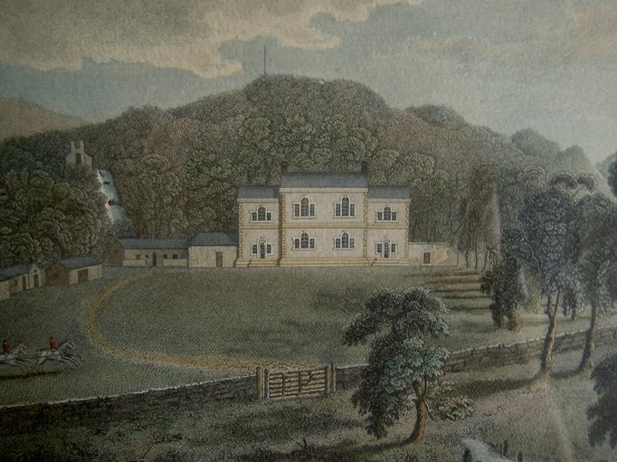
Look across the lawn at Barrow House and compare your view with the picture below.
Depending on the time of year you might be able to see Barrow Cascade, visible to the left of the house in the engraving. Even though the summer foliage usually conceals this view you can probably still hear the falls gushing through the trees.
Now look carefully at the picture to find a large JP on the gate. This engraving literally bears Joseph Pocklington’s signature but you can also see his influence on the landscape in other ways.
To the left of the house, the waterfall and the building above it both show Pocklington’s influence. Though the waterfall already existed he used gunpowder to make it even more spectacular and built a hermitage at the top. He named his new home Barrow Cascade House. He also shaved the branches off an oak tree, whitewashed it and fashioned it into the shape of an obelisk, attracting the incredulous comment from Samuel Taylor Coleridge that, ‘in the Pocklington domain, Art beats Nature.’
The oak obelisk no longer exists but, as tastes change, perhaps today we might enjoy Pocklington’s sense of humour. Though the Romantic artists and poets thought that the formal lines and symmetry of Barrow Cascade House jarred unsympathetically with the natural landscape, it is now Grade II listed and praised by many visitors.
Stroll back across the lawn to the drive. Turn left and walk to the bottom of the driveway. Cross the road with care and step down to the lake-shore beach. Go down to the edge of the water.
3 Pocklington's follies
From here on the lakeshore you can see the wooden jetty for the Keswick launch about 200 metres to the right. Look further right towards the north of the lake to spot Derwent Island. This was formerly known as Vicar’s Island and later renamed Pocklington’s Island.
Joseph Pocklington bought the island in 1778 and quickly adorned it with a large house and several follies. These included a boathouse in the style of a Non-Conformist chapel and Fort Joseph, from which he fired cannon and staged mock battles.
Pocklington felled most of the trees on his island and built a stone circle based on the prehistoric stone circle at nearby Castlerigg. He billed it as the ruined foundations of a Druid’s Temple. He also organised an annual regatta with ambitious and madcap activities such as mock attacks of his island and a swimming race for horses. Pocklington used the island as a stage for his dramatic ideas, and by firing cannon from his batteries he was able to demonstrate the echoes produced by the mountains, emphasising their size and grandeur.
Look at the engraving of the island (Image 3a) showing the house in the background and the boathouse near the shore.
The delightful map (Image 3b) drawn by Pocklington’s friend, Peter Crosthwaite, shows the island’s layout with inset pictures of the fort and druid’s stone.
However, Pocklington’s Island was not to universal taste. William Wordsworth, the Cumbrian-born Romantic poet, thought that Pocklington had defaced Derwent Water, going against the Romantic ideals of a simple, rustic life in a picturesque setting.
The Reverend Mr Shepherd was similarly scathing saying in 1804 that ‘the gingerbread erections by Pocklington destroy the harmony of the scenes and in a court of taste would be put down as a public nuisance’.
What do you think of Pocklington’s eccentricities? Do they improve or detract from your enjoyment of the view? Whatever your opinion, about 500 million years ago this view would not have existed. In fact standing here, you would have been under the Iapetus Ocean in the Southern Hemisphere.
If you look to the north of Derwent Water behind Derwent Island and the town of Keswick, you can see the broad shoulders of the Skiddaw Range of mountains. These mountains (or fells) were formed from compacted sediments that were laid down on the bottom of the Iapetus Ocean. These sediments were gradually uplifted, squeezed between converging plates, and transported into the Northern Hemisphere. Over the past 450 million years the landscape has also been shaped by volcanic action, ice and a lot of flowing water.
Pocklington’s follies on the island have since been dismantled and it is now owned by The National Trust. The house is still fairly prominent though and The National Trust revived the energy and ideas of Pocklington with a new regatta on Derwent Water in August 2013. Pocklington may have been criticised by several prominent aesthetes of his time but his activities drew lots of attention and they certainly popularised the area. His legacy in his buildings and the curious stories attached to them has contributed significantly to the interest and attractions of Borrowdale.
Walk around the lakeshore with the lake on your right. Cross a wooden footbridge (over Barrow Beck) from where the path becomes very well defined. Stop just after passing two large trees on the right where you should have a good view of the south end of the lake and the Lodore jetty.
4 Painting the picturesque
As you round the peninsula you will be able to see the southern end of Derwent Water with wooded crags to the left and sweeping fells to the right. Hopefully, if there has been enough rain, you will be able to glimpse the Lodore Falls amongst the trees – the waterfall appears to drop into the back of a large grey hotel.
This is a good point to compare our view with how nineteenth-century artists chose to depict it. The picture below is an engraving by Joseph Farington.
Notice how the shafts of light in Farington’s picture above draw our eye to the romantic subjects of the waterfall, the rugged mountain sides and the small rowing boat. Notice too how the point of view in these three pictures is the same as if the artist had taken his sketch pad or set up his easel right on the lake shore. Artists in the eighteenth and early nineteenth century generally preferred low-level views like these which had the effect of heightening the distant mountains in the background. In 1769, the poet, historian, and scholar Thomas Gray wrote: ‘I find all points that are much elevated spoil the beauty of the valley, and make its parts, which are not large, look poor and diminutive ... the picturesque point is always thus low in all prospects’.
Unlike the view from Barrow Bay in the late eighteenth century (where the follies of Pocklington were seen to jar against the landscape) this view towards the southern end of Derwent Water conformed to theories of the picturesque. Take a closer look at the painting by JMW Turner below.
The artist has included small, rustic figures dabbling tentatively on the edge of a rugged and varied landscape. The hint of a rainbow indicates the dramatic contrasts within the Lake District where heavy rain is often followed by glorious sunshine and sudden calm.
Although the lake in the foreground looks serene, the prominent Lodore Falls and the craggy layers of mountains are a strong reminder of the dramatic weather conditions and potential dangers of the environment. The Lodore Falls respond very quickly to rainfall, efficiently transporting water from the Watendlath Valley into Derwent Water. During dry periods they are not visible until you are standing beneath them but after a few hours of rainfall the white plume emerges and you can see the water tumbling through the trees. We will soon be standing beside the Lodore Falls where we will compare them to one of Turner’s sketches.
Continue along the lake shore path to reach Kettlewell car park. At the car park, cross the road and follow the path marked Lodore half a mile. Shortly after the entrance to the Mary Mount Hotel on the right, the path divides. Follow the left-hand path marked with an arrow. The path twists through woods. After a short descent, turn left to go uphill to the Lodore Falls viewpoint. There is a bench which you may wish to take advantage of.
5 The renowned cataract
This is the Lodore Falls. The sharp wooded points of Shepherd’s Crag are above to the right and Gowder Crag above to the left.
In 1778 the tour writer Thomas West wrote of Lodore Falls and the neighbouring crags: ‘Betwixt these, an awful chasm is formed, through which the waters of Watendlath are hurled. This is the Niagara of the lake, the renowned cataract of Lowdore’.
How do the Lodore Falls make you feel? Is this how you would describe them?
Many of the eighteenth-century travellers and artists thought that waterfalls like Lodore were ‘sublime’, a term used by the Romantics to refer to something of such scale and destructive potential that it could provoke feelings of terror and awe in its viewer.
Turner made a sketch here on his first tour of the Lake District. Painting the entire falls is an overwhelming task and it is particularly difficult to represent moving water but this sketch shows the processes behind a landscape study.
Perhaps, however, the task did become too great, for despite this sketch Turner did not go on to paint a detailed study of the Lodore Falls. Instead, in his later works like ‘Keswick Lake, 1835’ which we saw at the previous stop, the Lodore Falls are depicted as a distant plume without the intricate detail of water tumbling around individual rocks.
Robert Southey, the Romantic Lakeland poet, was also inspired by the shape and force of the Lodore Falls, writing ‘The Cataract of Lodore’ in 1820. The poem artistically represents the geography of the falls with the lines and verses cascading down the page in the shape of a waterfall.
High above, at the top of the Lodore Falls, is the Watendlath Valley which is hidden from view. The Lodore Falls are fed by Watendlath Beck, a stream which we will walk along in the later stages of the route.
These falls provide good evidence of the former presence of glaciers in this area. Long after the Lake District volcanoes became extinct, there were periods in which the valleys were occupied by glaciers with huge chunks of moving ice eroding them into distinctive U-shaped troughs. The glacier in the Watendlath Valley was a tributary of the bigger glacier in the Borrowdale Valley. The Watendlath Valley was not eroded as deeply as the Borrowdale Valley and so it was left hanging high above the deep Borrowdale trough.
When the ice melted, the water had to get from the Watendlath Valley to Derwent Water, and it took the easiest route, forming the Lodore Falls. The diagram below shows the way smaller side valleys are left hanging above the main valley after glaciation.
Retrace your steps towards the foot of the falls and cross the small metal footbridge at the back of the Lodore Falls Hotel. Follow the service road around the back of the hotel to meet the main Borrowdale Road. Cross the road with care and then turn left to walk along the narrow roadside footpath with a public toilet block on your right and the road on your left. Follow the roadside footpath for about ¼ mile until you are level with High Lodore Farm.
6 A serene scene
This is a good point to look back at Derwent Water and the Skiddaw Range. A similar view was painted by the artist Thomas Stothard.
This serene picture reflects the actual view on a hazy morning when everything is very still, calm and quiet. Stothard, who produced a great variety of art from book illustrations to murals, was seeking relaxation on his visit to the Lake District and so this restful scene may also reflect a mellow mood.
When he visited in 1809 he took several walks with fellow artist, John Constable, finding relaxation in their long strolls away from the demands of publishers. Stothard also collected many butterflies, discovering the Small Mountain Ringlet butterfly and building an impressive collection.
The highest mountain in the picture (and in the actual view) is Skiddaw at the northern end of Derwent Water. Notice the gap in the mountains where the River Derwent flows into Bassenthwaite Lake beyond and then on to meet the sea.
In the evening the last of the light comes through this gap. Unlike the previous paintings which looked south into the craggy, enclosing mountains, this study is more open and hopeful. It also reflects the difference in rock type between the two ends of the Borrowdale Valley.
The mountains that dominate the background of the painting are part of the Skiddaw Group of sedimentary rocks. Earlier we discovered that the sedimentary Skiddaw Rocks were uplifted as the Iapetus Ocean gradually closed. This caused volcanic activity in the Borrowdale area and the lava which issued from the volcanoes produced craggy, jagged rocks to the south of the valley known as the Borrowdale Volcanic Group (BVG). The BVG contains a great variety of rocks but they are generally craggier in their appearance than the smoother Skiddaw rocks.
Look around and compare the smooth mountains depicted in Stothard’s ‘View of Skiddaw’ (at the northern end of the valley) with the uneven crags of the Lodore side of the valley and the jagged mountains to the south and you’ll see the difference.
Continue along the roadside footpath with the road on your left. Pass the Borrowdale Hotel and the Leathes Head Hotel. The last section of the path moves down to the riverside, signposted Grange. Just before the path meets the stone bridge at Grange, turn right to walk through foliage to the stony river bed. Position yourself on the stones so that you have a good view of the bridge.
7 An awful amphitheatre
To the left and right are steep fell-sides. The crags on your left are now popular with rock climbers, so keep an eye out.
Notice the bridge ahead under which the River Derwent flows. Depending onb the volume of the river you may be able to see large areas of deposited stones dropped by the rushing water.
Grange Bridge dates from 1675 but it was rebuilt in the early nineteenth century. It links the hamlet of Grange with the Keswick-Borrowdale Road.
In 1769 the poet Thomas Gray made a tour of the Lake District and he recorded his observations in a journal that was published in 1775. He wrote of Grange: ‘Round it the mountains form an awful amphitheatre, and through it runs the Derwent, clear as glass, and showing under its bridge every trout that passes’.
About 450 million years ago it was the volcanoes of Borrowdale which helped to form this ‘awful amphitheatre’ of mountains.
The valley south of Derwent Water is mainly composed of volcanic debris with most of the rocks belonging to the Borrowdale Volcanic Group (BVG).
Grange is on the diagonal dividing line between the volcanic debris to the south and the gentler, even older Skiddaw Group to the north.
The rugged crags are therefore in strong contrast to the softer shapes and style of ‘View of Skiddaw’ by Thomas Stothard which we saw at the last stop.
In 1807 William Havell moved to Ambleside and toured the local area with his sketchbook, oils and paints.
‘Grange Bridge’ is a sketch that he made on one of his excursions. Byusing gouache (an opaque white pigment) on a paper of mid-tone rather than just the traditional sketching medium of pencil and white paper, Havell was able to better capture the subtlety of light and shade in the Borrowdale Valley. Havell has made the landscape look wild, forbidding and impressive but the bridge and the small houses are evidence of human habitation and control.
It was this scene that prompted Thomas Gray’s famous description, ‘the jaws of Borodale’, which is still quoted in guidebooks today. Mr Gray, our exaggerative eighteenth-century guide, was too afraid to go beyond Grange but we are going to forge ahead - through the craggy jaws and into the depths of the Borrowdale Valley.
Retrace your steps to the path and follow it up to the road. Continue along the roadside footpath with the road on your left all the way to the Bowder Stone car park. Cross the road but do not go through the car park. Instead, head for the wheelchair-friendly path signed for the Bowder Stone. Follow this firm, gravelly path with a fence and a disused quarry on your left. The path goes gently uphill to a gate. Go through the gate and continue along the path. Stop in front of the Bowder Stone.
8 A ship upon its keel
This giant, teetering rock is the Bowder Stone. Feel free to climb the ladder if you dare but be careful - the top of the stone can be slippery in damp conditions.
It’s quite surprising to come across this giant rock here in the Borrowdale Valley. For the Romantic artists and writers it was another feature which excited their sense of the sublime.
In 1778 Thomas West wrote: ‘[it] must excite the most sensible feelings of wonder and surprise, and at once impress the mind with reverential awe and admiration’.
Whether you feel ‘awe and admiration’, ‘wonder and surprise’ is up to you, but this nine metre high rock has ignited much debate about just what it is and how it got here. One theory is that the Bowder Stone came from a glacier which transported it here from Scotland during a period of glaciation. However, we know that the glacier which cut through the Borrowdale Valley flowed from south to north and there is no evidence of glacier-transported abrasion on the boulder’s surface. The more likely theory is that the Bowder Stone fell from the Bowder Crags above and settled here at the bottom of the steep hillside.
Those who support the rock-fall theory point to the other big boulders of the same rock type on the wooded hillside which were on the left as we approached the Bowder Stone. The crag collapse may have occurred soon after the last glaciation when the crag was weakened by ice action and freeze-thaw weathering.
Now let’s compare the stone in front of us with John Atkinson Grimshaw’s painting (Image 8). The style of this painting is hyper-real; it has a photographic rather than painterly quality. This suggests that Grimshaw was paying close attention to detail, staying faithful to the scene, ‘rejecting nothing, selecting nothing, and scorning nothing’, as recommended by the poet, artist and critic John Ruskin in 1843. Grimshaw was interested in photography and this probably inspired the meticulous realism and detail in his painting of The Bowder Stone.
With his keen eye for a tourist opportunity, Joseph Pocklington was the first person to lay a ladder against the stone. He also built a small house near it and installed an old woman there to show visitors around the stone. The Romantic poet Robert Southey described his Pocklington-influenced experience:
‘Another mile of broken ground, the most interesting which I ever traversed, brought us to a single rock called the Bowder Stone, a fragment of great size which has fallen from the heights. Here, an ugly house has been erected for an old woman to live in who is to show the rock, for fear travellers should pass under it without seeing it. The ground has been cleared around it and it rests upon a narrow base, like a ship upon its keel. A hole has been dug underneath through which the curious may gratify themselves by shaking hands with the old woman. The oddity of this amused us greatly, provoking as it was to meet with such a hideous building in such a place – for the place is as beautiful as eyes can behold or imagination conceive.’
Take the left hand path from the Bowder Stone. It becomes more uneven as it descends to the Borrowdale Road.
Go through the wooden gate at the bottom of the path and cross the Borrowdale Road with care. Turn left along the roadside path with the road on your left and the River Derwent on your right.
Follow this path for about ¼ mile until you reach a lay-by on the left where there is a wide wooden gate and a Public Bridleway signpost.
Cross over the road and go through the gate. Then follow the stony bridleway straight ahead in the direction of the signpost arrow.
The path ascends quite steeply at first, with an old stone wall on the right. The path then winds through woodland over a couple of small becks. After another steep climb you will reach a small wooden gate.
Go through the gate and follow the grassy path, traversing the hillside towards an area of coniferous trees. There are good views of the southern end of the Borrowdale Valley to the right.
Keep the conifer trees on your left and follow the path round to a kissing gate in a stone wall. Go through the gate and turn left onto a stony bridleway.
Follow the bridleway uphill passing ‘the six sisters’: one yew and five Scots Pines on the left.
Stay on the stony path (veering right) rather than following the grassy tracks that have been made by quad bikes. Follow the bridleway uphill until you reach a wooden gate.
9 Walking with ice
The path that we have just climbed crosses an area called Puddingstone Bank. During glacial periods it is likely that upper layers of ice from the main Borrowdale Valley glacier overflowed into Watendlath via Puddingstone Bank. So we are now following in the path of the ice.
At around 350 metres above sea level this is almost the highest point of the walk. Before continuing, look back at the flat valley floor and the surrounding mountains of Borrowdale. A similar view was captured in the lush canvasses of the artist May Stephenson.
We are lucky enough to experience the landscape on foot, sensing shape, height and colour while we walk but May Stephenson painted this part of the Borrowdale Valley from memory when she was confined to bed and starting to lose her sight. Her style is described as naïve, full of the innocence and joy of childhood and I admire the way she has evoked these optimistic emotions despite her ill health and old age.
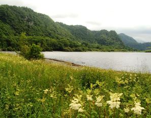
Go through the gate and continue along the well-defined bridleway. The path is fairly level for about ¼ mile then descends into the Watendlath Valley with glimpses of Watendlath Tarn through the conifers on the right. At the bottom of the path is a signpost for Rosthwaite and Dock Tarn. Bear left towards the neck of Watendlath Tarn and go through the wooden gate in the stone wall. Take a few steps and stop next to a large stone on the right (just before the widest part of the stream).
10 Unchanging landscape
We are now on the shore of Watendlath Tarn. This lake (or tarn) is a hollow which was deepened by glacial ice between 21,000 and 11,500 years ago.
If you look at an Ordnance Survey map you will see that there are many such tarns across the Lake District.
It is difficult to say how many times there have been glaciers in the Borrowdale and Watendlath valleys because each glacier destroys much of the evidence of previous glaciations.
However, the cumulative effect of glacial erosion can be seen in the U-shaped valleys, deep mountainside tarns and deposited material that you can see today, some of which have been subsequently shaped by flowing water and human activities.
Look back at the path that we have just come down and you will see the lowest point of the surrounding fells, just south of the path and the conifer trees.
This is the route which the overflowing ice from the main Borrowdale Valley might have travelled. Can you picture ice flowing down this into Watendlath?
Now compare our view of Watendlath Tarn with the painting by Sir Charles John Holmes. Holmes was born in 1868 in Preston and is best known for his paintings of bleak mountains and industrial scenes of Northern England.
Do you think Watendlath looks bleak in this painting? Though the colours and the light are everchanging and your view and experience of this landscape will be different depending on the weather, time of day and time of the year, the shapes and arrangement of the physical landscape (the topography) have not changed dramatically since this painting was made almost 100 years ago.
The light on the most distant mountainside suggests an evening scene. There are many steep gullies and bumpy hills around Watendlath and so the shadows and visibility of the landscape details can vary considerably.
How does the light affect your impression of the view? Notice that Holmes has chosen to focus on the physical elements of the landscape with a view of the fells rather than the farm buildings. The only evidence of human influence is the stone wall around the trees on the left.
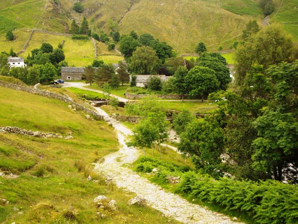
Continue along the beck-side path to the stone bridge. Cross the bridge and bear left to follow the road between two barns. Stop by the signpost for Rosthwaite and look ahead at the white cottage called Steps End Farm.
11 Spot the difference
The white cottage with a deep front porch straight ahead is Steps End Farm, a mid-seventeenth century farmhouse.
The English painter Dora Carrington and her friends stayed here during the summer of 1921.
Dora Carrington’s ‘Farm at Watendlath’ was painted just two years after Sir John Charles Holmes’ ‘Watendlath Tarn’ which we saw at the last stop.
However, you can see that they are very different in style. Carrington represents the more experimental, poetic style of a younger set of avant-garde artists.
The thoughts and feelings behind this painting are very different to those of the eighteenth and early nineteenth-century landscape painters. It seems to me a very intimate scene and the inclusion of the two female figures contemplating the view invites us to study the painting too. Some critics have interpreted this scene as a meditation on femininity with the two women reflecting on the fertile, undulating landscape before them.
Stand next to the bridleway signpost and compare your view of the farm and surrounding fields with the picture. See how many differences you can spot.
A local Lake District historian wrote to the Tate Gallery commenting that Carrington had distorted the Watendlath landscape in her painting: ‘She has squeezed the front barn. She exaggerates the humps on the skyline and smoothes the rocky cleft of Raise Gill.’
What do you think about Carrington’s creative response to the scene? It does look rather different from the view we can see here but the artist probably wasn’t interested in a documentary or realist approach.
Carrington was beset by strong emotions through her life. She spent many periods in considerable emotional turmoil and in 1932 committed suicide. However her Watendlath holiday had been a happier time and ‘Farm at Watendlath’ is described by her brother as ‘most representative of her best work and that at the prime of her life as an artist’.
Bear right to follow the sign for the National Trust car park. Walk through the car park where you will see an information board about Watendlath and a public toilet block. Go through the small wooden gate and take a couple of steps (just to clear the gate for other people!) before stopping in front of Fold Head Farm.
12 Farming the fells
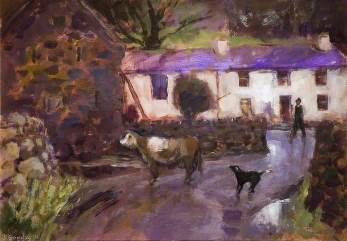
Compare your view to Donald Goodby’s painting ‘Farm at Watendlath’ which depicts a typical farmyard scene.
I have often witnessed the same scene as Goodby’s painting on my rambles through Watendlath: the working dog, the cow and the farmer are part of an important team, dependent on each other and the local environment.
Fold Head Farm is now a family-run sheep and beef farm. The National Trust owns the farm, the land and buildings of Watendlath, with tenant farmers abiding by their policies.
In total the National Trust manages about 12,000 hectares around Borrowdale.
They have a considerable influence in the area, maintaining the public rights of way and the access land. Their fences, signposts and erosion control are in strong evidence along our route.
Though Fold Head is both a sheep and beef farm, most of the farming you’ll see in the Lake District is sheep farming.
The sight (and sound) of sheep is a very distinctive feature of the Lake District landscape. The sheep are found on high, mostly unenclosed common grazing land shared by farmers from adjoining valleys.
The distinctive, shaggy coated native Herdwicks are prized for their robust health, their ability to live solely on forage, and their tendency to be territorial and not to stray over the difficult upland terrain common in the Lake District.
The National Trust has helped farmers to preserve the native Herdwick variety of the central and western Lake District fells. As you might expect, Herdwicks are very hardy, surviving on the steep fell-sides in heavy rain, strong winds, snow and ice. However, they have a low productivity, generally not lambing until they are three years old (two years old is the norm) and fetching the lowest price of all the wools in the United Kingdom. Their fleece is coarse and not easily dyed and tends to be used to make carpets.
Sheep farming in the Lake District is a difficult life. January to April 2013 were cold and very dry months with persistent snow on the fells. Lots of farmers had to bring hypothermic lambs into their kitchens, keeping lambs on Agas, in sinks of warm water and using hot-water bottles. There were also worries about the grazing lands: grass struggled to grow with very little rain and temperatures under 5ºC. Hopefully you will see lots of healthy sheep as you walk down the Watendlath Valley today.
Walk down the right side of Fold Head Farm to the edge of Watendlath Tarn. Turn right along the track, following it round to the stone bridge. Stand on the bridge.
13 Abstract reflections
This scene portrayed in the abstract painting by Ernest Pascoe is very different to the paintings by Holmes, Carrington, and Goodby, though taken from a similar viewpoint as Holmes’ painting of Watendlath Tarn.
In the 1960s Pascoe was teaching at the West of England College of Art.
He was preoccupied by a neoRomantic attempt to grasp the essence, something of the personality, of the English landscape.
He explored this in abstract paintings that were constructed, scrubbed and rubbed until the work emerged as if it had been burnished by time and the natural elements.
I think that in this abstract painting Pascoe is depicting the reflection of the fells in the water. Can you see any reflections in the tarn today? It is a strange sensation to look into the water and see the landscape from a different angle.
Just as reflections allow us to see the real landscape upside down and back to front, so abstract art makes us look at familiar things in different ways. I think that Pascoe is playing with this idea in his painting of Watendlath Tarn – our eyes are doubly-challenged by the abstract representation of the reflections!
Continue over the bridge and go through a wooden gate on the right signposted High Lodore and Ashness 1 ½ miles. Stop after just a few steps to look back at the bridge.
14 Please use the CORRECT address!
Notice how narrow this bridge is. If you are walking in a group you will have to cross in single file. That’s because it was designed for packhorses to cross, one horse at a time.
Notice too how low the parapets are on either side. It would be easy to fall in. These walls were built deliberately low to provide clearance for the heavy, goods-laden panniers on the back of the animals. Drovers also used the bridge to move sheep to market.
This tiny hamlet of Watendlath was described as ‘an exceedingly remote little valley lying among the higher hills above Borrowdale’ by Sir Hugh Walpole in his novel ‘Judith Paris’ (1931).
There is only one road to Watendlath and it runs for three miles, ascending steeply from the Borrowdale Road. It’s no wonder that Guy Nicholls’ painting of Watendlath was used for the General Post Office’s Correct Address Campaign
In such a remote place where the postman often encounters difficult driving conditions, you definitely want to make sure that the post is addressed correctly!.
Continue along the path towards Ashness. You will be walking down the Watendlath Valley with Watendlath Beck to your right. Follow this path for about 1 ¼ miles until you reach the large wooden footbridge which crosses Watendlath Beck.
Just before you cross the bridge, look down at the cobbled path to see a triangular stone marking the three directions in which you can travel.
You are now going to follow the route towards Keswick. Cross the bridge and follow the path for a short distance until you reach a wooden gate on the left.
Go through the gate and follow the stony path, climbing gradually uphill. Where the path meets the road at a footpath signpost, turn left along the road. After a short distance is a small car park on the right and a great view on your left. Walk down to the viewpoint which is known as Surprise View.
15 Surprise, surprise
This craggy precipice is 234 metres above sea level. In front of us, far below, is Derwent Water.
You can see the glacially carved U-shaped valley of Borrowdale and in the distance on a clear day you can see over to Bassenthwaite Lake.
In each glacial period the Borrowdale Valley was occupied by ice and the sheer rock face beneath Surprise View is the result of glacial erosion and subsequent rock falls.
From here we can really appreciate the height difference between the Watendlath Valley we have just walked through and Derwent Water below. The Watendlath Valley and beck truly hang above the Borrowdale Valley.
There is also a good view of Derwent Island to the north and its treesurrounded house. Joseph Pocklington would have stood very proudly at this spot surveying his island and its adornments.
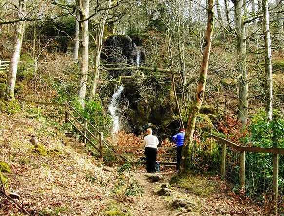
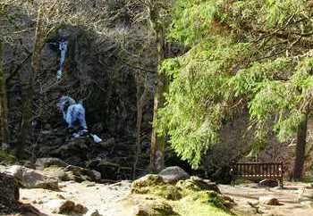
Rejoin the road and follow it downhill all the way to Ashness Bridge. Cross Ashness Bridge and continue along the road for a short distance until you reach a gate on the left. Go through the gate and follow the path with Barrow Beck on your left. Stop at the bottom of the first flight of stone steps next to the padlocked wooden gate. From here you can see the top cascade and plunge pool of Barrow Falls.
16 From the sublime to the ridiculous!
This dramatic waterfall is fed by Barrow Beck which we just saw flowing under Ashness Bridge. Joseph Pocklington built a dry-stone dam on the lip of the highest plunge pool, helping to channel the flow towards the eastern side of the gorge, providing a better view of the cascades from the house.
When the water level in the cascade is very low you can see this diversion more clearly. Pocklington also used gunpowder to make the gorge walls steeper and the waterfall more dramatic – his account books of 1787 to 1803 include the entry ‘gunpowder for blasting’.
On the other side of the footpath, almost level with the top of the waterfall, you might be able to see the natural cliff face covered in foliage. This formed the back of a mock hermitage.
Pocklington made several drawings for the design of the hermitage and it was built in 1795. He wanted someone to live inside it but no one applied! There is very little evidence of the building today but we can just see it in Thomas Allom’s drawing of Barrow Cascade made in the 1830s.
It includes human figures in either romantic repose or reacting dramatically to the Cascade with arms outstretched. The mock hermitage is visible in the far left of the the drawing, tucked among the trees above the couple sitting by the falls.
Continue down the footpath to the rear of Derwentwater Hostel. This will bring you round the leftside of the house and you will emerge onto the terrace, back where we started.
17 A walk of art
We have now reached the end of our walk around the Borrowdale Valley. Our Walk of Art has explored the physical and cultural geography of the area. The stories of mountain-building, volcanoes, glaciation, rivers, farming, architecture and art have transported us through 490 million years of geological time and explored three centuries of creative human relationships with this ever-changing landscape.
We have now arrived in the modern day. Compared to periods of glaciation this is a relatively warm and wet environment where water and humans are the main agents of landscape change. This is also a time of on-going creative engagements with the landscape.
Barrow Cascade, with its stone dam and small hydro-electricity plant, is an example of both watery and human forces as well as an on-going source of artistic inspiration, seen in the local art groups who come to paint scenes of the waterfall and grounds.
During our walk we have seen a variety of landscape art exploring a range of aesthetic tastes, techniques, and styles. These art works and the stories behind them have provided an insight into the physical and human history of the Borrowdale landscape.
Pictures are not always reliable geographical guides but hopefully you will have enjoyed the experience of spotting the difference between the images and their subjects.
The Romantic artists and writers had a strong influence on the way people perceived the Lake District landscape in the eighteenth and nineteenth century. However, aesthetic tastes and theories are not fixed in time. Rather they are like a spirit afloat which could arise in any person at any time.
Have you found beauty, interest, horror or ugliness in this walk? Have you seen views and features that you think would make good subjects for a picture? Whatever your experience, I hope you’ve enjoyed this fascinating corner of the Lake District!
A circular walk from Derwentwater through the Borrowdale Valley
"The wildest, the most barren and frightful place"... was how the Lake District was viewed 300 years ago. Immortalised by painters and poets, today it's one of the most visited areas in Britain.
This walk takes you on a journey through three centuries of landscape art to explore how artists have responded to and shaped this dramatic landscape.
Stand where painters like JMW Turner and Dora Carrington set up their easels to consider how much the landscape has changed. Reflect on how much our 21st century view of the Lake District has been influenced by Romantic notions of beauty and the Sublime.
On this walk, you'll find out how this landscape has been shaped by dramatic physical processes and by pioneering enthusiasts who embellished natural features and built eccentric follies.
Follow the walk by clicking on the map pins or downloading the guides below
Katy Moore for creating this walk, providing photos and the audio commentary
Caroline Millar and Rory Walsh for edits and production
Jean Norgate and Martin Norgate for providing scans of archive images
The Dock Museum, Harris Museum and Art Gallery, Royal Birmingham Society of Artists, Royal West of England Academy, Science & Society Picture Library and Tate Britain for kind permission to reproduce the artwork featured
Brian Clift,David Iliff and Fiona McCarthy for providing additional images


.jpg)
 © Tate Britain")
.jpg)

.jpg)
.jpg)
.jpg)
.jpg)

.jpg)