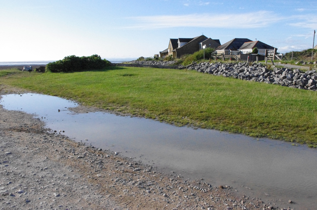
This trail begins at Potts' Corner, a sandy car-park in the liminal space where the land of Sunderland Point merges with the saltmarsh and mudflats of Middleton Sands and the wider Morecambe Bay.
At the sandy car-park, face inland towards Carr Lane then turn right and follow the coastal track towards Sunderland Point.
After 5 minutes walking, the track swings left and becomes a farm access road. Ignoring this, continue along the footpath at the base of the flood bank. You will be walking on the inner edge of the marsh; take time to stop and look out across the vastness of Morecambe Bay.
2 The marsh
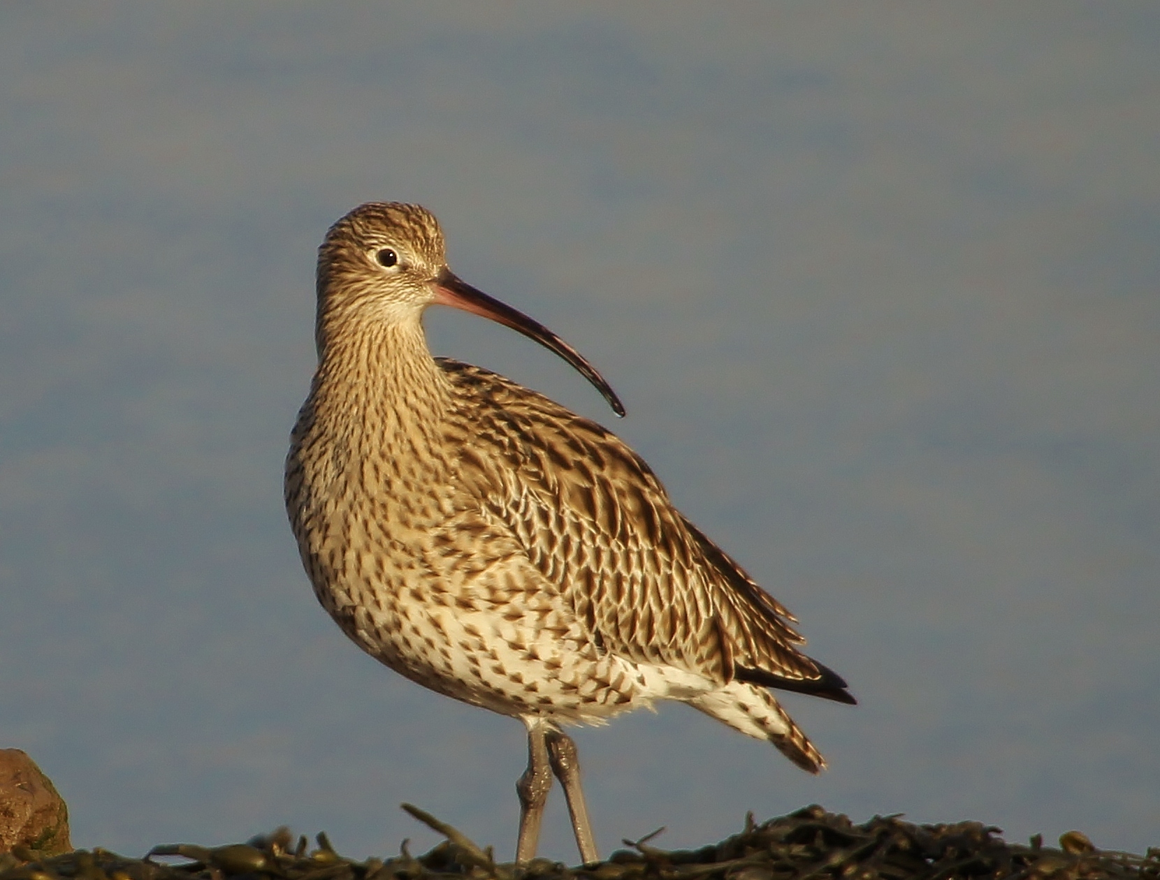
Look out for evidence of high tides in the detritus left behind in the tide-line – blue rope, marsh grass, feathers and shells. Depending on the state of the tide, there will either be an emptiness of ochre-red sands or full-tide, and every stage in-between. Time your walk as the tide begins to return and you will be rewarded with hosts of wading birds zipping along the shoreline – knott and dunlin, turning, changing colour from dark to light in a flash of flight. The pied beauty of oystercatchers too, piping their insistent call as they wing in ahead of the tide.
Wading birds use the saltmarsh, mudflats and channels to feed. Keep a watch out for curlew – although an iconic bird of the British coast and countryside, it is a species that is in worrying decline due partly at least to the over-intensification of farmland. Listen for their evocative bubbling, rippling call. Morecambe Bay hosts some of the largest over-wintering flocks of curlew, migrating in to the bay from Russia and Europe. Other waders, such as sanderlings, are only absent from the bay for their brief breeding season (May to July,) in the Arctic. Whilst for humans the area represents peace and quiet, to wading birds it is a hugely important source of food – their equivalent of a motorway service station!
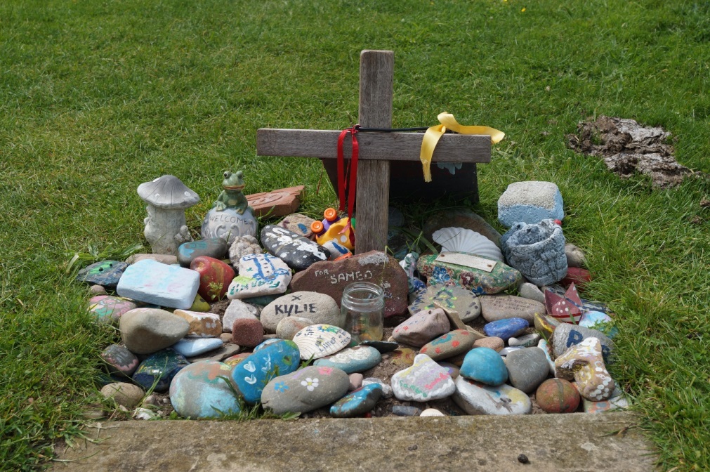
Continue along the marsh and you will reach a signpost indicating a left turn towards Sunderland village. Turn left through the gate and 15 yards up the lane take a right turn onto the new access footpath, past a bird hide and the 'Horizon Line Chamber' installation by Chris Drury, and further along to where there is a small stile in the stone wall surrounding 'Sambo's Grave'. Climb the stile and enter the small enclosure.
3 Sambo's Grave
The grave in the small enclosure commemorates a young African slave boy who was put ashore here in 1736 and abandoned. It has a life of its own; depending upon the season, there might be flowers, Christmas ephemera, tin boats, toy animals and messages painted on stones all clustered underneath a low wooden cross. After 4 days, and with no apparent offers of help, the boy died a very lonely death of some unreported disease. Flat in the grass is a gravestone inscribed with a poem and dedication, installed by the Reverend Watson some 60 years after the young boy’s death.
Lancaster was then the fourth largest port in the UK involved in the slave trade, and Sunderland village was developed as an out-port (a subsidiary port built in deeper water) before Lancaster’s wharf was constructed. Ships set out from here to sail to Africa’s west coast, navigating inland by river and acquiring 29,000 slaves between the years of 1736 and 1807. Some of the goods used for barter in this miserable human trade were iron ore dug from the hills of Furness, beads, mirrors, hats and brass pans.
Slaves were rarely brought into the country through Lancaster, though about 40 country houses in the vicinity boasted ownership of black servants. The boy put to shore here was consigned to history with the patronising sobriquet of ‘Sambo,’ or ‘Samboo,’ – a word used then to describe people of African heritage. The recognition of shifting attitudes – albeit just over half a century after the boy’s death - are illustrated in the final words of the Reverend Watson’s poem:
‘the Great Judge his approbation founds Not on man’s colour but his worth of heart.”
Just beyond the enclosure is a wooden seat created from the trunk of a washed-up tree. Take a few moments to sit and consider that if one spooled backwards through time, caravels (small sailing ships) might be seen, their pennants (flags) flying as they set out on the tide, bound for Africa’s west coast. The earliest ship to sail from Sunderland Point, The Lambe, was bound for Jamaica in 1687. Clearly, tradesmen from this small city showed scope of ambition and aspiration in the face of developing patterns of trade. Although today Sunderland village may seem like a backwater, in the seventeenth century it was bound up in global trade thanks to its waterways and maritime position.
300 years ago, young men were invited into local inns at the appropriately named Snatchems and Catchems. Once plied with wine and unable to stand upright, they were carried off to ships at Sunderland Point and forced into labour. Which must have been worst – the mighty hangover, the rolling ship or the realisation that there was no going back? They must have thought they were sailing to the edge of the world.
Retrace your steps from the grave past the 'Horizon Line Chamber' installation (it is worth pausing to exame the image in the camera obscura within it). Continue back along the path to The Lane. Turn left to regain the path along the forshore.
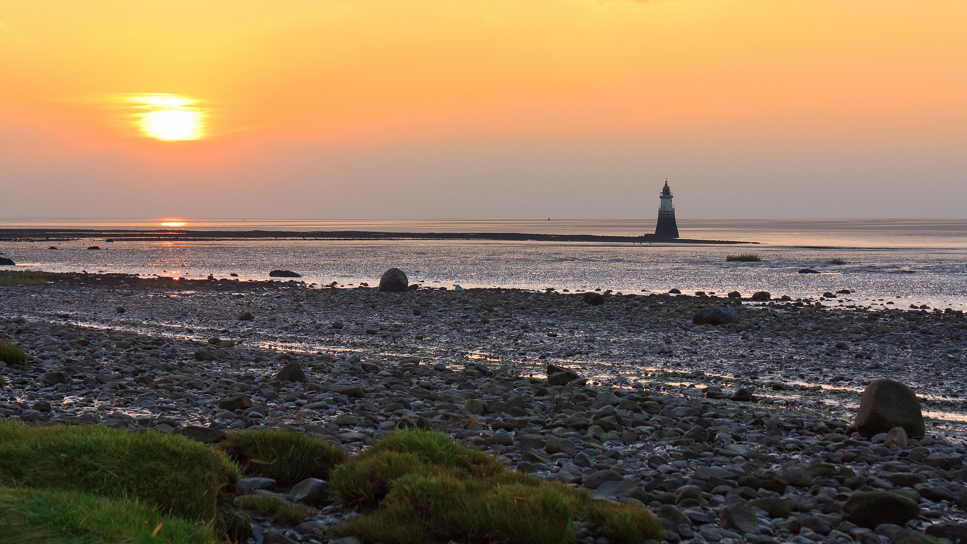
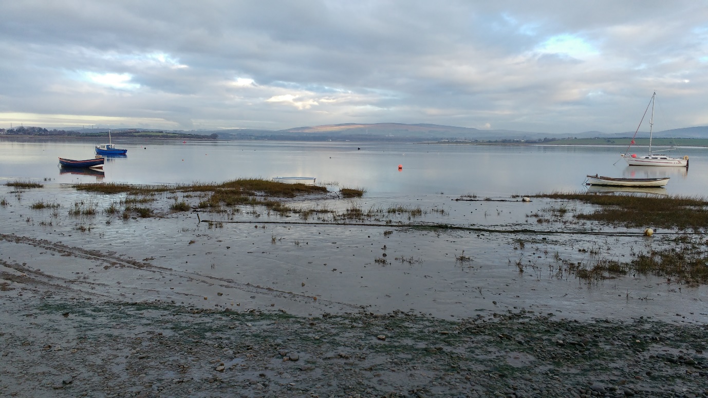
Continue south, with the sea on your right, to where the beginning of the point itself and the outfall of the River Lune come into view. Go through the gate and notice in the mouth of the River Lune - just out into the bay, the attractively named Plover Scar lighthouse.
4 Looking to Plover Scar Lighthouse
Did you see the lighthouse? There is a chance you might not have done! In 2016 the tower of Plover Scar lighthouse was struck by a passing ship. After being dismantled, it is currently in the process of being reconstructed again, brick by brick. When you have a spare moment, take a look at http://www.britishpathe.com/video/lighthouse-1 for Pathé newsreel dating from 1948, showing assistant lighthouse keeper, Mrs Parkinson, striding across the sands at low tide in her wellies, coat and hat, and climbing the tower to polish the lenses and light the kerosene lamp.
Now turn and look across the bay (in the direction of Barrow-in-Furness) to the southernmost point of Walney Island and its lighthouse. Like Plover Scar, it was built as a navigational aid to shipping entering the Lune. At Walney, the remarkable Peggy Braithwaite held the post of keeper until she retired aged 74. She was awarded the MBE and gained the distinction of being Britain’s only ever principal female keeper.
Peggy was born on tiny neighbouring Piel Island, which you may also spot on the horizon with its castle ruins. Peggy’s father ran the small ferry between Piel and the mainland. When he was appointed assistant principal keeper for Walney Island, he moved his family and all their possessions across the channel in a small open boat. Peggy, her sister Ella, her grandmother and the family’s piano were all crammed in on the final trip.
Although it’s a tough life constantly negotiating the sands and tides, lighthouses like Plover Scar have enabled people to navigate and trade here for decades.
Walk around the point, keeping an eye out for blackbirds foraging in the hedgerow up on the bank. You will need to walk on the foreshore as the field here is private land. Take care as the foreshore can be slippery underfoot. Once around the point, step up onto the footpath which leads to the village.
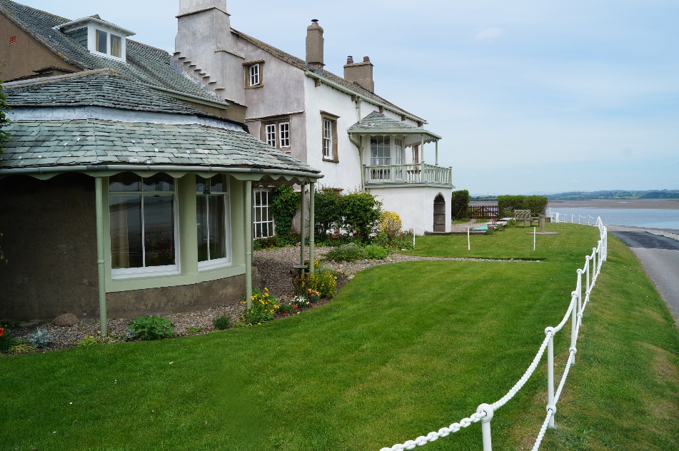
5 Sunderland Hall
Stop for a moment to take in the splendour of Sunderland Hall. Arriving here, there’s a sense of both time and place having slipped, as if you have arrived by accident in some idyll on the coast of Devon. The Hall is a genteel residence worthy of architectural comment. Built by merchant Robert Pearson who lived there with his wife Elizabeth, look out for the inscription REP 1683 on the wall. (The Hall and the next 2 dwellings are now the last buildings, but it was thought that long ago, 2 or 3 small cottages existed in the field behind the point.) On an historic deed of sale the hall boasted a dining room of 18 square feet and a drawing room 24 feet long.
Should the tide be incoming, watch for the melding of currents out in mid-stream. Salmon travel up-river on the filling tide and are still caught by the ancient tradition of haaf netting, thought to have been introduced by Viking settlers. One of the last exponents is Sunderland resident Margaret Owens. Margaret dons full fishing gear, walks out into the river until she is chest-deep in water, then waits for salmon to swim inside the 3-metre-wide net. This unusual style of fishing has enabled residents to fish in the shallow waters of the sand and mudflats. It’s an extraordinary tradition kept alive in an extraordinary setting of shifting waters and sands.
Continue walking along the village track to Cotton Tree Cottage.
6 Cotton Tree Cottage
Another link to Sunderland’s role in the slave trade was the Cotton Tree that, until recently, grew outside Cotton Tree Cottage (where we are standing). As a mature tree it towered over the houses. More recently it was actually identified as a female black poplar, but it was originally thought to have grown from a seed in a bale of cotton, imported from America as part of the slave trade triangle. Black poplar seeds are a fluffy mass easily mistaken for cotton.
The tree clung on for over 250 years until it was finally sundered by gales in 1997. So while it proved not to be a cotton tree, the enduring name nevertheless reminds us that this quiet village was once a bustling trading post thanks to its location on the River and Bay. (Though that particular form of slavery ended with the Slavery Abolition Act of 1833, it is worth remembering that illegal slavery continues across the world today.)
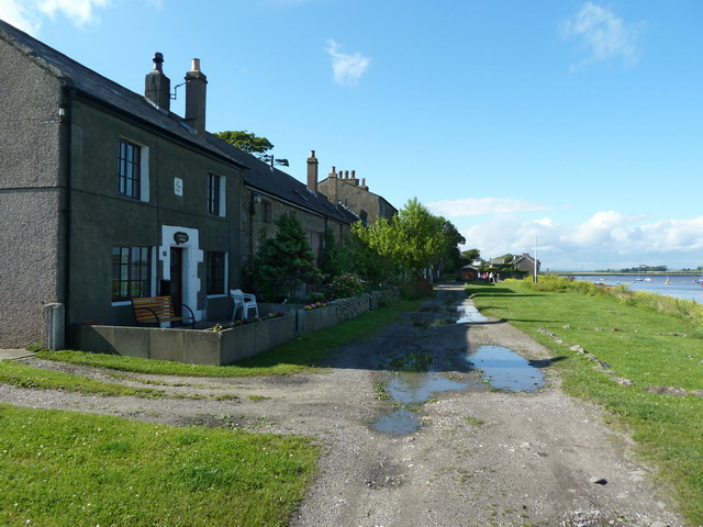
Although the terraced cottages have been for some time separate dwellings, in the out-port’s heyday they were joined internally for ease of access and movement of cargo.
Keep walking with the houses to your left. Pass a sign-post indicating the route across the point to Sambo’s grave, and take a few minutes more to walk on to the end of the village. (At No. 3, you can purchase an excellent guidebook to Sunderland Point’s history.)
From the stony car-park you can wander up the saltmarsh to see a few old trawlers that are slowly disintegrating. Don’t be tempted to cross the causeway road unless, having consulted tide tables, you are sure of timings. On the far side is the village of Overton.
Retracing your steps, just before arriving at the signpost again, have a look over the edge of the quay at a peculiar brick structure.
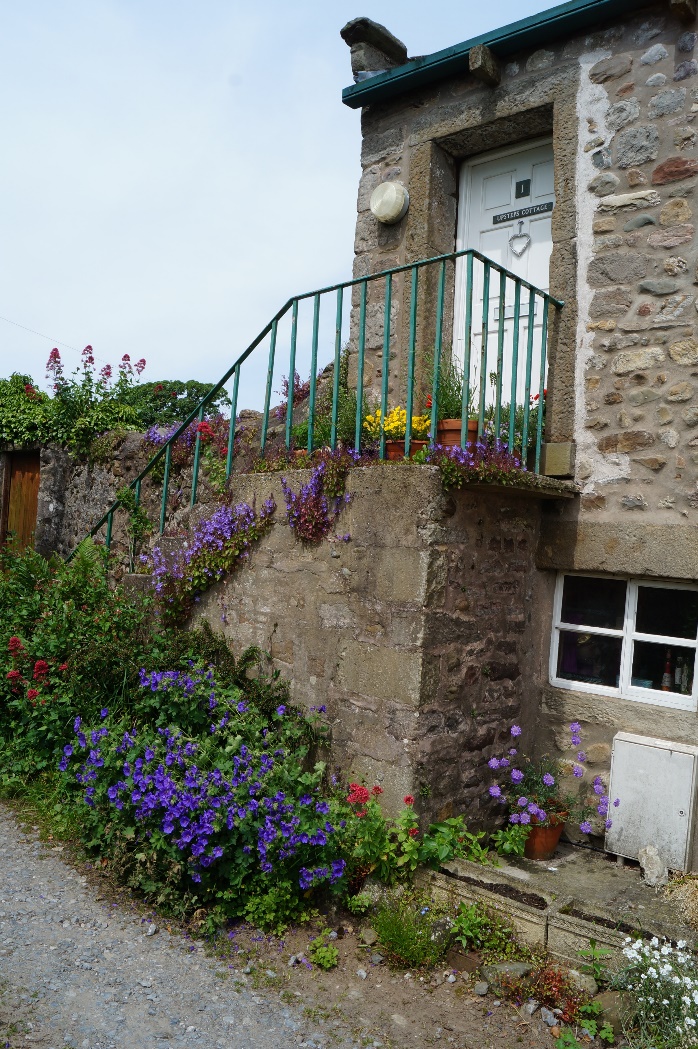
7 Bathing tank and Upsteps Cottage
This brick structure dates from the days of sea-bathing. Water was caught in the tank from the high-tide, and pumped into what is now the ground floor of Upsteps Cottage. Turn into the lane and you will see the cottage, complete with exterior steps, where the curious and adventurous of the Victorian era would immerse themselves discreetly in a bath of the fabled waters – though there was nothing so bold as actually immersing oneself in the sea!
In its nineteenth century incarnation, sometimes called ‘Little Brighton on the Lune,’ Sunderland offered not only a health cure but a holiday destination, thus ending its post-trade era nickname of ‘Cape Famine.’ So, for a new generation of visitors the waters surrounding Sunderland Point became its key attraction. Alas, the regeneration was short-lived, overtaken by Morecambe which had developed into the resort of preference – a place much more easily accessed.
Upsteps Cottage is also the former brew-house of the Ship Inn, (No 11,) and it was here that the young slave boy Sambo ran when he was put ashore, fleeing up the steps. After 4 days, he died a very lonely death. Records show that villagers occasionally peered in through the gloom, mystified and perhaps also more than a little nervous, presumably, not only because of his illness, but also because of the colour of his skin.
The column by the sea complete with a ball on top is all that remains of a once fine pair of gate posts leading to an avenue of trees and The Summer House. Turn right into the lane, following the signpost, and The Summerhouse is the last house on the right. It was built as the lookout tower from where coastguards kept watch for incoming ships. Notice as you pass by the two long windows on the seaward side.
Inside the building, sadly destroyed at some point in history, there was once a compass painted on the ceiling and attached to a weathervane on the roof. Coastguards could determine the direction of the wind therefore, without the need to go outside.
Follow the lane across the narrow peninsular – a short half-mile, keeping watch for birds feeding in the fields – curlew and lapwing and rabbits too.
8 The shore
The lane emerges once more onto the saltmarsh, just north of Sambo’s grave, and there again is that wide view across the saltmarsh and the bay to the rolling Furness Fells. Take a look, then turn right to begin the leisurely stroll along the marsh back to Potts Corner, leaving behind the mystery and eccentricity of lonely Sunderland Point, dwarfed in all senses by the twin megaliths of Heysham Nuclear Power Station ahead of you. There may be an Ireland-bound ferry departing from Heysham port – ploughing through one of the deepest sea-trenches of our coastal waters, the Lune Deep.
Before you leave the coast, it’s worth a look over the saltmarsh and the bay to see if any of the multitude of wading birds the area is famed for, are visible – the redshank, greenshank, curlew, dunlin, knott and the oystercatchers riding the wind ahead of an incoming tide. The birds are the thread that holds this landscape together; they were here as the Vikings travelled in from their bases in Ireland and the Isle of Man, and as the slave boy Sambo was put ashore at Sunderland and left alone to die. They are too, symbols of the wild and the ever-changing nature of the landscape.
A short walk exploring a unique peninsula near Morecambe Bay
Positioned on the edge of Morecambe Bay between the River Lune and the Irish Sea, Sunderland Point is intriguing and unusual. Walking along the Point, a strong sense of place emerges – of mudflats, marsh, of river and sea.
This small peninsula is cut off twice daily by the incoming tide, creating a perfect environment for wildlife. Watch for wading birds foraging in the mudflats or flocking together in their spectacular aerial display. Salmon enter the Lune here and we may see them being caught mid-river by traditional haaf-net fishing
This trail discovers this former port’s maritime history, its role in the slave trade and how it was transformed into a tourist destination.
Follow the trail by clicking on the map pins or downloading the guide below
Potts' Corner, end of Carr Lane, Morecambe (nearest postcode LA3 3LL)
Grid reference:
SD 41327 57220
Getting there:
Follow signs off Middleton Road for Middleton Towers Retirement Village. Follow Carr Lane to where it ends in a car park by the sand.
Keep an eye out for:
Birds! Curlew, redshank, greenshank and oyster-catchers winging over the saltmarsh and the edge of the bay.
WARNING:
The Causeway to Overton is likely to be under several feet of water for 1 to 2 hours before and after high tide. If walking or driving across from Overton village, tide tables must be checked. This trail does NOT require use of the Causeway.
The start of this trail - Potts Corner - can be cut off by high spring tides, so please consider this carefully depending on the time of year you will be walking.
Weather conditions can also affect the height and time of tides. Please take this into account when planning your walk. This should not discourage walking here, but due consideration and caution are required.
Sunderland Point / Morecambe Bay trail credits
Thank you to:
Karen Lloyd for devising, writing and photographing this trail
Helen Rawling for edits and suggestions
Terran Brown for the main photograph of Sunderland Point via Wikimedia Commons CC BY 2.0
The inhabitants of Sunderland Village live their lives entirely dependent upon the tides - travelling to school and work early or returning home late, depending on whether the causeway road is clear of water.