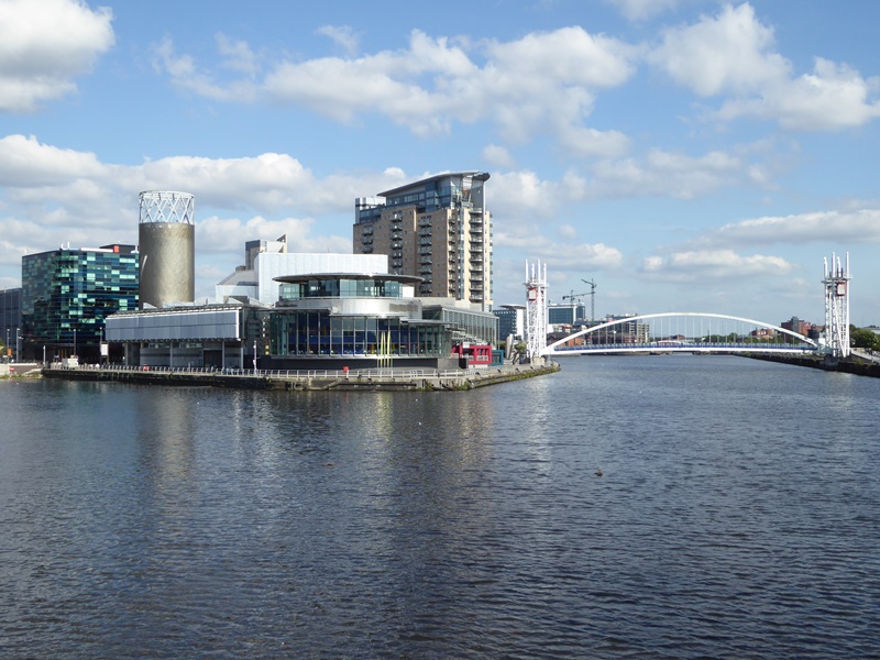
We begin the walk with a sight that may seem familiar. If you watch television there’s a good chance you’ve seen this spot before. This large open square, The Plaza, is often used for outdoor filming on shows including BBC Breakfast, Watchdog, and Children in Need.
Surrounding us are BBC offices, television and radio studios where some 3,200 people work on a variety of programmes. And they aren’t alone. Nearby are some of ITV’s studios, including the set of Britain’s oldest and most-watched soap, Coronation Street. We’ll see the outside of it a little later, next to the Imperial War Museum North.
The BBC, ITV and the Museum are part of ‘MediaCityUK’. The 200-acre site includes many more media and technology companies, plus the University of Salford, hotels, restaurants, and shops. Around 7,000 people work at MediaCityUK for over 250 businesses.
This modern 'tech town’ is part of Salford Quays, one of the largest redevelopment projects in Europe. As recently as 2007 none of these buildings existed. Instead we would be looking at scrubby wasteland used for car parking.
A century earlier, the view was different again. In place of the glossy offices, we would see warehouses and cranes. And the water would be full of ships. From the 1890s this area was part of the Manchester Docks.
These Victorian docks were the foundation stone of today’s ‘media city’. During their prime, Manchester became Britain’s third-largest port, after London and Liverpool. Yet Manchester is almost 40 miles inland. Why build a set of docks so far from the sea? And what caused their transformation a century later?
Map of Salford Docks (1924), Wikimedia Commons (CCL) Click on the picture to enlarge it
Directions
With your back to the water, bear left from the middle of The Plaza towards the building called Bridge House. Before you reach Bridge House turn left. Continue ahead onto the footbridge and stop about halfway across. Look over the left hand side, with the BBC studios on your left and ITV studios on your right.
2 View of the Manchester Ship Canal, MediaCityUK Bridge
From this bridge, take in the view over Salford Quays. When the BBC announced plans to transfer staff and studios here from London, comedians had a field day. The move from the capital to derelict dockland was widely mocked. Over a century earlier, so was the other major feature we can see.
We are now above the Manchester Ship Canal. This vast waterway allowed ships into Manchester direct from the Irish Sea. Today the waters look calm and quiet. The story behind this scene though is one of most the radical and controversial in Britain.
By the 1840s Manchester had become the world’s first industrial city. Manchester was nicknamed ‘Cottonopolis’ after its booming cotton industry. Yet the city's landlocked mills and factories relied upon coastal ports for trading cotton plants and finished textiles.
Manchester’s nearest port was Liverpool, 31 miles away. To Manchester’s leading businessmen, Liverpool’s port and rail fees were too expensive. It was often cheaper to transport goods through Hull, 80 miles away on the other side of the country. So they proposed building a Manchester port, with a canal to bypass Liverpool’s docks.
The press ridiculed the idea. But not everyone laughed. Liverpool could lose valuable trade. There were also fears that the canal might silt up Liverpool’s natural harbour on the Mersey Estuary. Unsurprisingly, Liverpool’s port authorities fiercely opposed the scheme.
After years of debate, however, an Act of Parliament approved it in 1885. Construction began two years later. To complete the canal around 16,000 men and boys toiled for six years. The works cost £15million, equivalent to £1.6billion today. But there was arguably a greater price. The water below us became a deep source of Liverpool-Manchester rivalry.
When Queen Victoria opened the Manchester Ship Canal on 21 May 1894, it was the largest in the world. Ships entered the canal at Eastham on the south bank of the River Mersey then cruised to Manchester Docks through 36 miles of rural Cheshire.
The final stretch of the canal was created by adapting the River Irwell. To our left large dock ‘basins’ branched off it, like teeth on a comb. To our right, another transformation was underway.
Manchester Ship Canal from the same spot, Flickr (CCL) Click on the picture to enlarge
Manchester-Sur-Mer a cartoon mocking the proposal for the Manchester Docks (1882), Wikimedia Commons (CCL) Click on the picture to enlarge
Opening of the Manchester Ship Canal by the yacht Norseman (1894), Wikimedia Commons (CCL) Click on the picture to enlarge
Directions
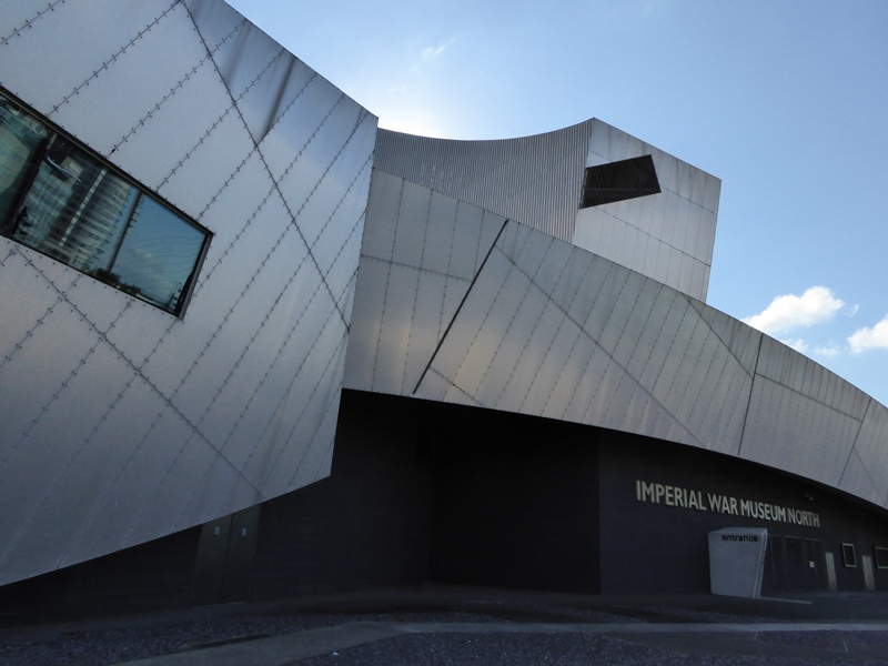
Continue over the bridge then turn left. Stop outside the Imperial War Museum North.
3 Imperial War Museum North, Trafford Wharf
The iconic Imperial War Museum North opened in 2002. Its startling design recalls a shattered globe and represents the world ravaged by war. This international theme reflects local heritage as this area was heavily bombed in the Manchester Blitz of 1940. In fact, the museum was built on a bomb site.
Look at the yellow building peeping out from behind the museum. It’s a Hovis grain mill. The museum sits on the edge of Trafford Park, Europe’s first (and still largest) planned industrial estate. During the Second World War factories in Trafford Park made military equipment, including Spitfire aeroplane engines, so the site became an enemy target.
By crossing the Ship Canal towards Trafford Park we have entered another district of Greater Manchester. The canal separates Salford (to the north) from Trafford (to the south).
Salford is a separate city from Manchester, complete with its own cathedral. In fact the name ‘Manchester Docks’ is a bit misleading. Only one of the nine docks was actually in Manchester. The other eight were in neighbouring Salford.
Trafford meanwhile is named after a wealthy family who owned land here for centuries. By the Victorian era they lived in a grand mansion, Trafford Hall. Trafford Park was their surrounding 1,000-acre estate, where deer roamed scenic meadows and woodland.
Worried about pollution, the Traffords moved out when the Ship Canal opened. The new landowner planned to create a luxury village, complete with a golf course and boating lake. High costs put off investors but Trafford Park’s location - opposite the docks and beside the canal – appealed to manufacturing and distribution companies.
So from 1898 Trafford Park industrialised. Soon 17,000 people worked here in huge factories. The largest belonged to British Westinghouse (later Metro-Vick), electrical engineers who helped to set up the BBC. Other firms based at Trafford Park have included Kellogg’s, Ford, Brooke Bond and Unilever.
Incredibly, deer roamed Trafford Park until 1900 and workers would spot them during lunch breaks!
Map of Trafford Park (March 1906), Wikimedia Commons (CCL) Click on the picture to enlarge it
Postcard of the British Westinghouse Works, Flickr (CCL) Click on the picture to enlarge it
Directions
With the Ship Canal on your left, continue past the Imperial War Museum North and head towards Lowry Bridge (the arch-shaped bridge with two very tall columns at each end). Go onto the bridge and cross the canal. When you reach the end, bear left along the ramp and stop outside a silver building shaped like a series of tubes and blocks.
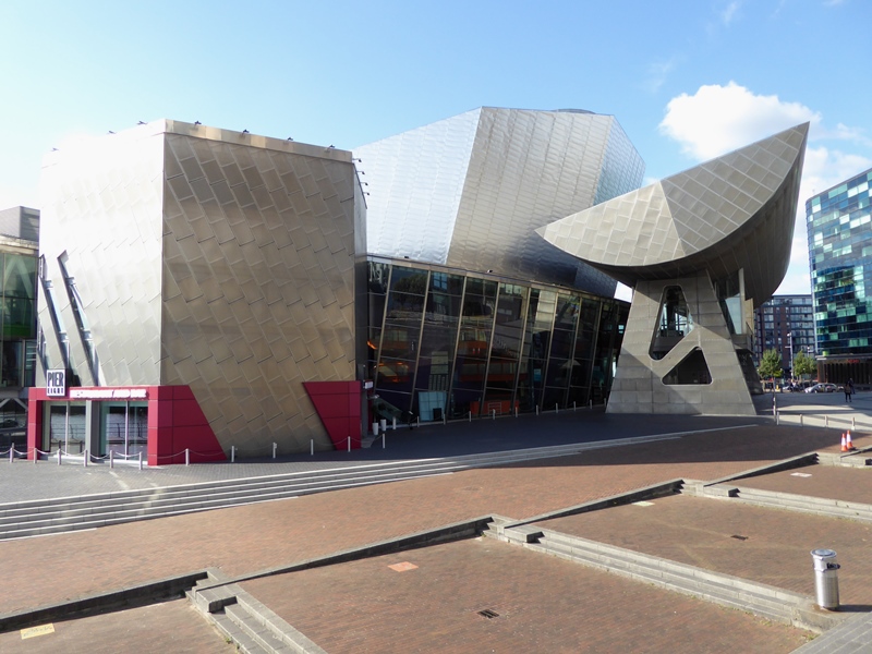
4 The Lowry, Pier 8, Salford Quays
This unusual silver building is The Lowry, an arts venue including theatres, galleries and a cinema. Opposite is the Lowry Outlet shopping centre. Both buildings - and Lowry Bridge we’ve just crossed - are named after Salford-born artist LS Lowry (1887-1976).
The Lowry building displays a large collection of his work. LS Lowry portrayed local scenes - streets, parks, factories, football grounds - packed with crowds of ‘matchstick’ figures. He often visited Manchester Docks to sketch and paint. It’s interesting to speculate what he would make of the area today.
Look around. This modern pedestrianised complex could be in a town centre. It’s possible to forget that this was once an industrial site. The buildings that bear Lowry’s name are a good place to ask what happened to the docks. Where did the working landscape go?
Soon after the Ship Canal opened, the Manchester Docks carried over one million tonnes of cargo per year. Their peak came in the late 1950s when they handled 18 million tonnes and employed 5,000 people. Yet the docks were never the commercial success that the original investors hoped.
To prevent Manchester taking their trade, existing ports (like Liverpool) reduced their fees. Some introduced exclusive contracts that barred companies from the Ship Canal. Shipping firms that used the canal found it increasingly expensive and time-consuming. There was a speed limit of 6 knots (around 7mph) and ships often returned to sea empty.
The major cause for the docks’ decline though was shipping containers. Before containers developed in the 1960s, large teams of men loaded and unloaded ships by hand. Containers made moving cargo much quicker with fewer workers. To carry more containers, ships grew bigger. Soon the Ship Canal became too small for them.
When the Manchester Docks closed in 1982, 3,000 people lost their jobs. The land was cleared and Docks 1 to 5 (the Pomona Docks) were filled in. Docks 6 to 9 (the Salford Docks) were regenerated to create Salford Quays. At the next stops we’ll explore how.
Going to Work, L S Lowry (1943), Wikimedia Commons (CCL) Click on the picture to enlarge it
Tanker on the Manchester Ship Canal, Flickr (CCL) Click on the picture to enlarge it
Directions
With The Lowry entrance behind you, turn left. Follow the rest of the building towards a roundabout. Carefully cross the end of the dockside road on the left. Continue a short distance to a gold building (The Alchemist bar). Pass the bus stop outside it then carefully cross the road towards another large area of water. Keep the water on your right and follow the path around it until you reach a group of three curving tower blocks.
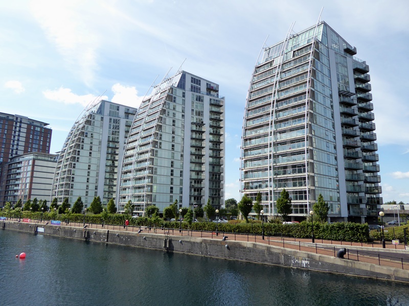
5 NV Buildings, Huron Basin
So far we’ve seen mostly commercial buildings, from offices and shops to museums and galleries. Some of the earliest developments at Salford Quays though were houses.
Across the water, notice the redbrick estate. Dating from the late 1980s, they were among the first homes built at the former docks. Most of the newer properties here are blocks of flats.
This striking trio beside us are the NV Buildings. They overlook the former Dock 9. At half a mile long, this was the largest basin in Manchester Docks. Lining the water’s edge, the metal T-shapes are mooring rings that secured up to ten large ships.
From the 1890s to the 1980s ships arrived here from around the world. Cargoes included United States cotton, Canadian grain, Baltic timber, Indian tea, Jamaican rum, bananas and citrus fruit from the West Indies. Besides cargo ships, passenger liners also cruised through Dock 9 to the US, Canada and the Mediterranean.
Instead of luxury flats, the docks then were surrounded by warehouses and sheds. Dock workers lived further away in rows of terraces (Coronation Street was said to be modelled upon Salford’s back-to-back houses). Jobs in the docks were physically demanding with long hours yet men were often employed casually, day-by-day.
It’s remarkable that this noisy crowded workplace has become a quiet residential area. Developments like the NV Buildings reflect how Salford Quays has become a very desirable place to live. In early 2018 several flats were on sale here between £300,000 and £600,000. Such prices would have been well beyond the reach of most dock workers.
Notice the NV Buildings’ curved fronts. They are designed to recall ship sails. Their outline may reflect the past - but their presence shows how the docks have changed.
Dock 9, Flickr (CCL) Click on the picture to enlarge it
Docks 9 and 8, Wikimedia Commons (CCL) Click on the picture to enlarge it
Directions
Continue along the dockside path to the red and blue metal bridge. Use the steps or the ramp to go onto this bridge and then stop halfway across. With the NV Buildings on your right, look back along the water.
6 Detroit Bridge, Huron Basin / Eerie Basin
The impressive Detroit Bridge provides a shortcut across the dock and links the residential areas. Built by the same company that made the Tyne Bridge in Newcastle, it has only been at this spot since 1988. And it wasn’t always called Detroit Bridge.
Did you spot a round plaque by the steps? If not, notice how wide the bridge is, despite only pedestrians and cyclists being able to access it. This was originally a twin-track railway bridge. It spanned the Ship Canal so freight trains could run between Manchester Docks and Trafford Park.
The bridge was part of the Manchester Ship Canal Railway (MSCR). With 231 miles of track, the MSCR became the largest private railway in the world. After the docks and railway closed, Detroit Bridge was floated here along the canal. The move required a special licence that classed the bridge as a ship!
When Detroit Bridge arrived here Dock 9 was effectively split in two. The waters are now called Huron and Eerie Basin after two US Great Lakes. These names - and nearby Canadian ones like Ontario, Vancouver, and Winnipeg - recall how ships arrived at Manchester Docks from across the Atlantic.
From the bridge we can see such great sea journeys are no longer possible. A road now separates the dock from the Ship Canal. To see why, look carefully for circles bubbling on the water’s surface. They show where pumps have been fitted in the dock to improve the water quality.
For almost a century the Ship Canal was densely polluted with industrial waste. To make the docks safe for housing and other developments the water had to be cleaned. So the basins were isolated from the canal and their water is constantly ‘aerated’ (pumped with oxygen).
Plants, artificial reefs and 12,000 fish have been introduced to encourage wildlife. Now birds including swans, grebes and cormorants are regular visitors. The water is so improved that Salford Quays has earned Blue Flag status, an award for cleanliness usually given to beaches.
Continue over Detroit Bridge then turn left. Keep the water on your left and follow the path past the houses. After a short distance a small canal (the Mariners Canal) will emerge on the right. Turn right and use the ramp or steps to join the lower grass-lined path alongside this canal. Keep the Mariners Canal on your left and pass beneath three bridges. At the end, stop by the dock basin to the left and look across the water.
7 Ontario Basin
We are now at Ontario Basin, formerly part of Dock 8. Here we can see why clean water is important. Ontario Basin (and the Mariners Canal we followed) is used for watersports, including sailing and windsurfing, canoeing and kayaking, paddle boarding and power boating.
Salford Quays has hosted many watersport competitions, including the 2002 Commonwealth Games triathlons. This is very appropriate as water has always shaped this area. Indeed Manchester is often described as Britain’s ‘rainy city’. But why is this region so wet?
The story starts on the other side of the world but with a very British topic – the weather. In the North Atlantic, tides create an ocean current called the Gulf Stream. The Gulf Stream generates warm winds, which carry moisture towards Britain in a north-easterly direction. Here in North West England they create a mild climate with plenty of rain.
Greater Manchester feels every drop because of its low-lying location. Rivers and streams flow into the region under gravity. They are helped by local clay soils. The Salford Docks were dug from a clay marsh, previously used for horse racing. Clay is ‘impermeable’, which means it retains water. Clay soils prevent water from draining away through the ground.
We are also at the foot of the Pennine Hills. Though not especially tall, their location creates an effect called ‘uplift’. The Pennines act like a ramp, sending air from the Gulf Stream upwards. When air rises, it cools and dampens - then falls as rain.
So the prevailing wind, location, and landscape soak the region. This wet weather can be annoying but it also helped Salford, Manchester, and other nearby towns to become large cities. From the eighteenth century, the abundant water drove mills and steam engines while the soft clay soils were ideal for cutting canals.
The major product was cotton. Cotton grows in hot countries but the delicate plants can easily burst open and perish. So cotton weaving relies upon damp climates which keep the plants intact. Manchester was ideal. Cotton was imported from British Empire trade territories like India and the southern United States then spun into textiles on water-powered looms.
From Ontario Dock, turn right. Follow the path between the Watersports Centre and Operations Tower. Go up the ramp and continue along the tree-lined path with the Ship Canal on your left. Across the canal is Old Trafford, the Manchester United football stadium. Look on the canalside railings for signs for Manchester Ship Canal Cruises. Stop when you reach the sign marked Gate 2.
8 Centenary Walkway, Salford Wharf
Take in the view across the water. We have reached the Ship Canal’s widest point. This ‘turning basin’ was built so ships could manoeuvre in and out of the docks. Today the canal’s only regular traffic comes from tour boats.
The gates here are a departure point for Manchester Ship Canal Cruises. Notice that the cruises are operated by Mersey Ferries. Given the canal’s origins, it’s ironic that such a symbol of Manchester now hosts an icon of Liverpool (and that the signs are opposite Old Trafford football stadium!).
The reason is that the Ship Canal and the Port of Liverpool are now owned by the same company, Peel Holdings. Competition has become collaboration. Unlike many other industrial waterways in Britain, the Ship Canal was never nationalised. Pleasure boats may have replaced cargo ships but the canal is still a private enterprise for making money.
The footpath beside these gates includes an installation called the Centenary Walkway. Take time to read the row of circular plaques in the ground, inscribed with quotes and poems. They were unveiled in 1994 to celebrate 100 years of the canal.
At a literal turning point, celebrating both heritage and modernity, the Centenary Walkway highlights wider questions. Has Salford changed for better or worse since the docks closed? What has been gained and lost?
Throughout this walk we’ve explored the regeneration of the Manchester Docks. But this area has been transformed twice. Long before the studios and the ships, this was a rural riverside lined with fields, farms and deer parks. Change is a constant here. And there is more to come.
Nearby Manchester is one of the fastest growing cities in Europe, which creates pressure for housing and facilities in surrounding areas like Salford. New companies are moving into Trafford Park, new developments are being built throughout Salford Quays, and plans have been approved to double MediaCityUK’s size by the year 2030.
Whatever your feelings about Salford Quays, we hope you’ve enjoyed exploring the stories behind this dynamic, evolving place. Return again in a few years’ time and who knows what we’ll see?
To return to MediaCityUK, keep following the Centenary Walkway with the canal on your left. You’ll soon reach Lowry Bridge and The Lowry building will be on your right. You can return to IWM North by crossing the bridge here or to MediaCityUK by turning right and passing the Lowry entrance.
Your browser is out of date, and unsupported by this website. Please upgrade to the latest version to use this website.
Manchester Ship Canal and Salford Docks c.1930, Wikimedia Commons (CCL)
Salford Quays trail
A short walk exploring the regenerated Manchester Docks
Coronation Street and Countdown… Mastermind and Match of the Day... CBBC and 6Music… welcome to one of Britain’s starriest places.
Some 35,000 people live or work at Salford Quays. This gleaming complex in Greater Manchester includes houses, museums, galleries, and most famously, television and radio studios.
Yet at the turn of the millennium this was an empty brownfield site, rescued from the remains of derelict docks built nearly 40 miles inland.
From ghost trains and banana boats to race horses and wild deer, explore the stories behind the headlines of this modern media landmark.
Follow the trail by clicking on the map pins or downloading the guide below
“It was a smelly, horrible place with beautiful ships. And now it’s a beautiful place with no ships.” - John Baker, former Manchester Dock Office worker


 We begin the walk with a sight that may seem familiar. If you watch television there’s a good chance you’ve seen this spot before. This large open square, The Plaza, is often used for outdoor filming on shows including BBC Breakfast, Watchdog, and Children in Need.


 The story starts on the other side of the world but with a very British topic – the weather. In the North Atlantic, tides create an ocean current called the Gulf Stream. The Gulf Stream generates warm winds, which carry moisture towards Britain in a north-easterly direction. Here in North West England they create a mild climate with plenty of rain.

