There is no secret to the main feature of this walk: Sand. Children digging pits with plastic spades, the hooves of ponies kicking it up and, if it is dry enough, the wind blowing the grains along in drifts reminiscent of a scene from the Sahara.
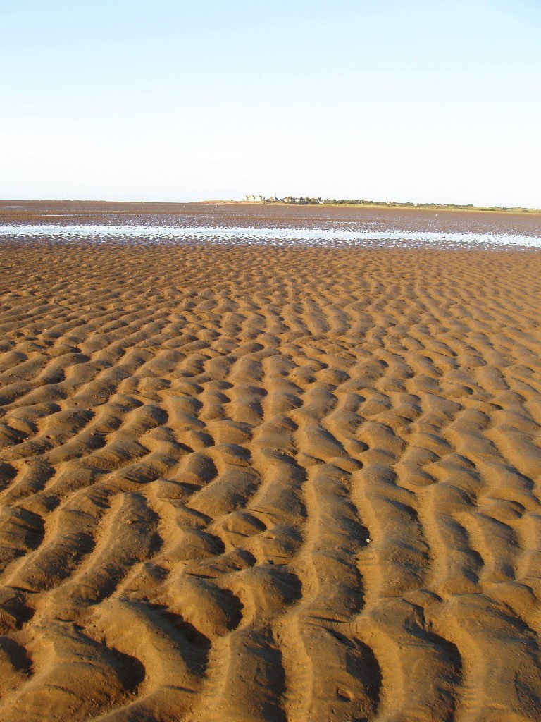
For long stretches, the sand displays mesmerising ripple formations on its surface. These are caused by the gradual ebb and flow of the tidal water, which covers this huge expanse twice a day. The ripples are punctuated by what look like curious little castles... the casts of lugworms also busy moving the sand, from their burrows deep beneath.
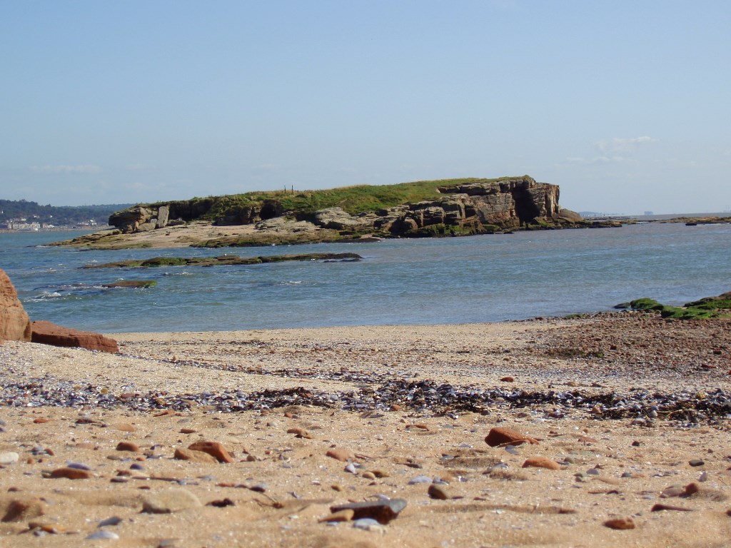
Take a deep breath: there is a marvellous sense of empty, open space here; the eye searches for a landmark to fix on. The main Hilbre Islands are the only feature ahead, but we are heading for Little Eye, that small mound of dark rock, just to their left.
If you haven't already, head out over the sands on a line at right angles to the promenade. Make for the small dark mound of Little Eye (i.e. not the main islands) and stop when you reach it.
2 Little Eye
This may be the smallest of the three islands – and let's face it, you really could not get an island much smaller than this tiny patch of rock - but there are a number of things to notice.
The first could be the extent of bird droppings and lost feathers. Little Eye provides a safe, undisturbed resting spot at high water for wading birds that have been feeding on the mudflats. Listen for their calls and look out for their footprints in the wet sand when we move on.
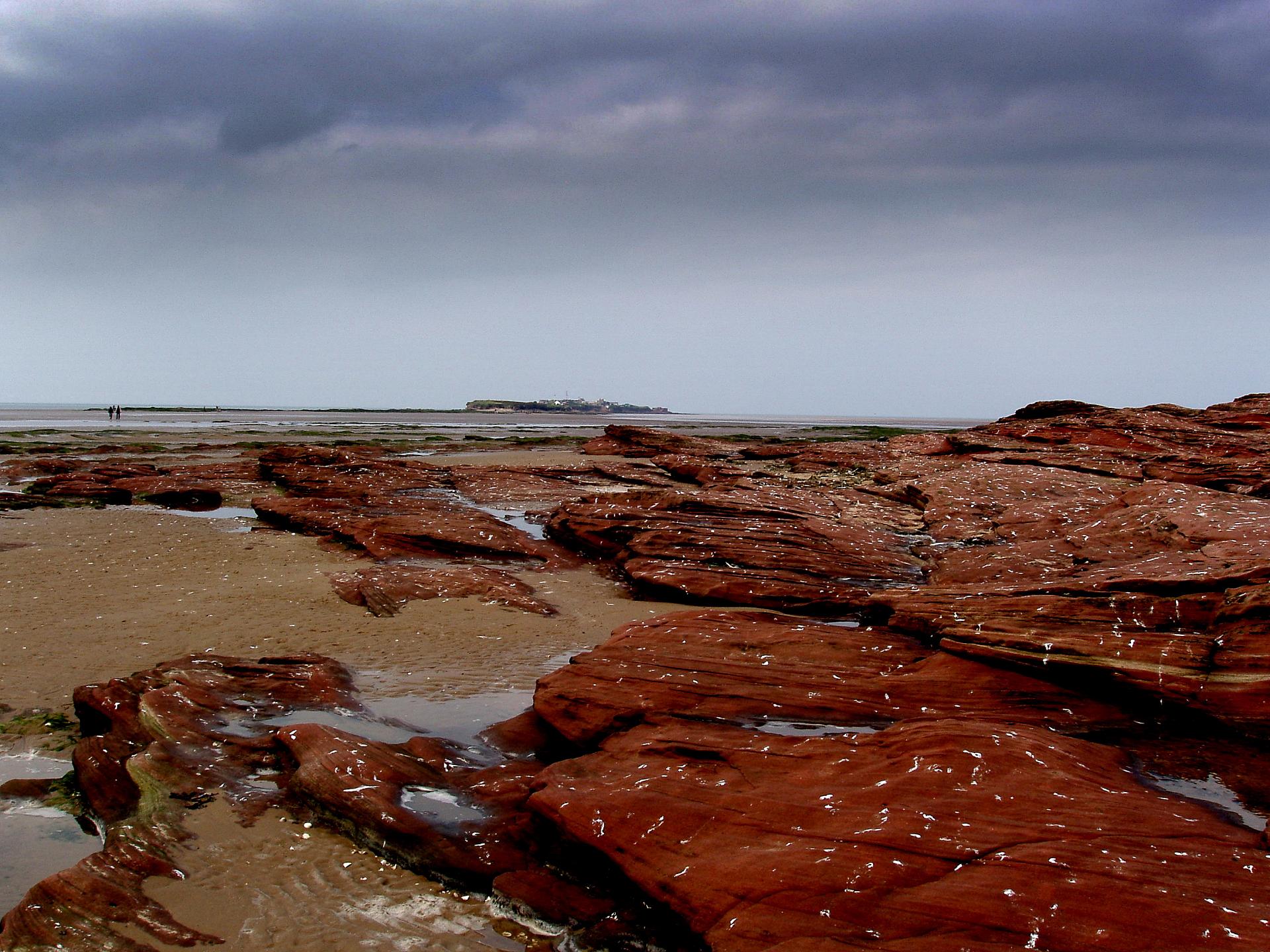
The second is the rock itself, how red it is and, on closer inspection, how it too is made up of almost nothing more than sand. Scratch a piece with your fingernail and you will dislodge a few grains very easily, to add to the trillions...
The sandstone stretches ahead for most of the way now, and you will see that it constitutes the great bulk of the Hilbre islands, which are in fact one continuous outcrop. They only become three, distinct entities for an hour or two around high tide.
To your left, the water is that of the Dee estuary. You may well notice that the going looks much murkier in that direction; mud is being carried downstream by the tired old river from far inland and deposited here along its last banks.
To your right, the sand (and some mud) is effectively an arm of the same estuary. It fills up with sea water very quickly as the tide rushes in – hence the recommended safe route we are taking.
Let's continue along the sand and rock towards the next island, avoiding the mud-coated areas of rock to the left which can be very slippery.
Now aim for the small beach at this end of the next island; when you reach it (not before) turn left and go around the corner, over the rocks a short way to explore the low cliffs facing the main estuary.
3 Middle Eye's cliffs
NOTE: On the OS map this is still marked as Little Hilbre Island, but today it is known as Middle Eye.
We have taken a slight detour to look at these low cliffs around the corner and on the south east side of Middle Eye, with the Welsh coast opposite. And what a dramatic change in landscape. The gentle undulations of sand are gone and we are faced with a jumble of broken chunks of rock.
This side faces the prevailing wind as well as the beginnings of the open sea; welcome to the world of coastal erosion. It may seem calm today, but in winter waves smashing against these rocks can fling their spray right over the island. They also have the power to undercut this cliff face, causing the square blocks to fracture and fall off.
Take a look up at the cliff itself. Not so long ago, in seaside souvenir shops, you could buy little bottles filled with many coloured layers of sand. This is effectively what we are looking at, only not something from a few decades back, but 230 million years...
Imagine we were here then. It is the Triassic Period (the one just before the Jurassic) and we are standing in the middle of a hot, dry desert. In the distance to the west loom high mountains, a newly formed range which will one day comprise the Appalachians. Yes, we have gone so far back that the Atlantic Ocean does not even exist!
There is a sea though, the Tethys, not so very far away to the east. So enough moisture is available to cause heavy seasonal rainfall over the mountains, resulting in sudden floods. In fact the hot, dry desert at times holds enormous lakes. As the flood water spreads out across the flats, it brings with it debris – sand – eroded from the old sandstone of the mountains.
With each successive flood, this sand settles in layers on the bed of the temporary lake. Depending on the kind of rock that is being eroded upstream, a different colour of material might be transported here. Building up in layers over thousands and then millions of years, our stripy new sandstone – or ’new red sandstone’ as it is known, no matter what the colour - is the result.
Let's retrace our steps a little and then climb on top of those ancient layers of sand to survey the wider picture.
Go back to the small beach and follow the footpath to the top of the island, then walk along to near the far end.
4 Top of Middle Eye
In May and June the soft springy grass on top of the island is awash with Thrift, or ‘Sea Pink’– a sure sign that this soil is regularly watered with salty spray from those winter storms.
Thrift is very resistant to salt. It's also a very comfy spot for a picnic - but make sure you get to Hilbre Island or back to West Kirby before high water. The rangers are not fond of folk being stranded here with its complete lack of shelter or facilities.
Looking back to the mainland, the surprising thing about West Kirby is how undeveloped it seems, especially given that the centre of Liverpool is only half-an-hour away by a regular train service. This is partly due to planning restrictions, but there has been another force at play – right where we have been walking.
Historically, going to the seaside has always included a swim in the sea as an essential option. Even with the sea fully in at West Kirby, these days you have to wade a long way out to get a paddle as far up as your knees. The truth is that the seaside is packing up and moving out.
We rightly stress the safety precautions of walking this trail, but just a few decades ago there was much more urgent need behind these warnings. The sea between Hilbre and the mainland was deeper, the islands cut off for longer by the tide.
The process of silting up has been going on for centuries in the Dee. The city of Chester, now far inland, was a Roman sea-port but ceased to be so by the middle of the fourth century. Later, the village of Parkgate, north of Chester on the Wirral coast, was developed as a port.
In 1742 the composer George Frideric Handel embarked there, sailing to Ireland for the first performance of his oratorio The Messiah. Visit Parkgate today and something seems out of place; a little seaside promenade facing miles of thick, green saltmarsh.
So, the Hilbre islands are caught in a double-whammy of opposing forces. On the one side the easily-eroded sandstone is being eaten away by the pounding waves. On the other, the estuary arm is filling up with mud being brought down by the river and sand blown, or carried, on the prevailing winds and currents. Whichever force gets there first their status as islands, even tidal ones, is doomed. It is ironic then that these same processes of erosion and deposition formed their beautiful rocks in the first place.
Descend to the right on the footpath, with care. Then keep to the sand on the right to reach South Beach. (The rocks around the central tidal pool are extremely slippery in all weathers).
5 Rocks at the entrance to Hilbre Island
Here at this end of the main island we have the two opposing forces at work within a few metres of each other.
On the tiny, sheltered South Beach, sand is steadily building up. Its blown here by the prevailing wind and also pulled around the island by the tidal current, to be deposited as the tide recedes. Meanwhile just around the corner, (where the main track ascends from the rocks) attempts are being made to slow the pace of erosion. You can clearly see where the waves have been undercutting the cliffs in the winter and the stone work laid against this process at the base.
It is worth having a good explore all around the area of flat rock. You are quite likely to find some squarish-looking shapes, a few centimetres in width. If they remind you of cracks in a dried-up muddy puddle, don't be too surprised; that is exactly what they were. The hot sun must have beaten down on our shallow Triassic lake, driving off the water and cracking the mud's surface in this familiar way. Quickly covered by the next layer of sand or mud, the pattern was preserved as a fossil.
If you are extremely lucky you may find something even more amazing: The footprint of a very early dinosaur. About the size and shape of a very large man's hand, these have turned up in newly exposed slabs at the base of the cliff. For a long time no one was really sure what the creature looked like, but it was given a name anyway: Chirotheruim (‘chiro’ being Greek for ‘hand’).
Recently, a skeleton found in Swiss Triassic rocks, of a reptile known as Ticinosuchus, was shown to have very similar characteristics in its foot structure, so our beast may well have been one of these. It looked a little bit like a Komodo dragon but with an erect not sprawling gait, giving it a very fast turn of speed. Carnivorous and at about three metres long, it is not something you would want to meet while out for a paddle.
Engraving of Chirotheruim prints featured in The Geological Magazine, Decade 6. Vol 1. No.9 (1914) Reproduced from Wikimedia Commons (CCL)
Directions
Take the track up onto Hilbre Island and follow it all the way to the end; continue along the footpath and over the flat sandstone.
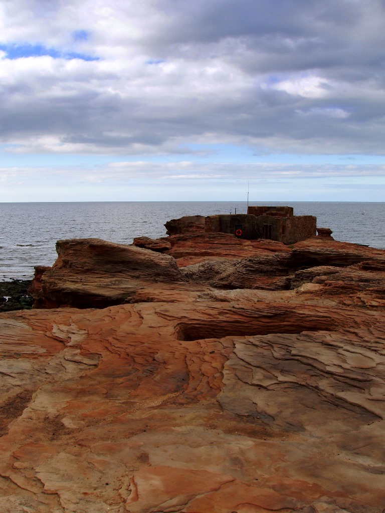
6 The tip of Hilbre Island
Lashed by ferocious winter storms and looking directly out into the Irish Sea, not even grass or Thrift can exist at this, the barren end of the Hilbre.
The shell of the old lifeboat station, now used by ornithologists as a lookout for sea birds, is made of the same red sandstone. Look for the weathering fireplace inside - it must have warmed many a sodden, half-drowned sailor, along with a tot of rum. Its former slipway is one of the best places to observe grey seals as they bob around among the rocks, often looking back at us humans with great curiosity.
Behind us, the telegraph station was part of a great coastal chain, long before electrical signalling. It extended all the way from Holyhead in Anglesey to Liverpool with a series of signal stations, Hilbre being one.It was able to transmit a message from a ship off North Wales to the Port of Liverpool in under half-an-hour, purely by visual means.
There is a huge amount of history bound up in the few buildings that still exist here, dating all the way back to a small monastic church of the eleventh century, (long vanished). No doubt the monks who came here then were drawn by the island's remoteness. The island’s name is thought to derive from that of their saint, Hildeburgh.
As the Middle Ages went by Hilbre become more and more busy with various enterprises, including a dock. So the brothers deserted their church by the middle of the sixteenth century. Now, perhaps, the island has returned to something of the tranquil life enjoyed by their holy order. The forces of nature, silting up and erosion, have made other ways of human existence more difficult all along the ever shifting Wirral coast.
Listen very carefully for any sound being carried on the wind... The haunting moan from seals out on one of the Hoyle sandbanks could just be taken for the ghostly chanting of Saint Hildeburgh's erstwhile monks.
For a different route on the way back, find the path down to the sheltered coast of the island, which runs between a shed and the study centre. Then follow the shorelines of both Hilbre and Middle Eye towards Little Eye and then the slipway.
Your browser is out of date, and unsupported by this website. Please upgrade to the latest version to use this website.
‘The sands of time’ is an everyday expression, originating from the days when an hourglass was a common system of measurement. This trail around the tidal Hilbre islands puts a whole new spin on the phrase.
For the most rewarding experience, reach Hilbre Island itself before high water and allow yourself to be stranded there for a few hours - but see below!
Follow the trail by clicking on the map pins or downloading the guide below
Essential safety information
When planning your visit it is absolutely essential to consult the tide times in advance. These are available at the BBC's Weather website (click here). NOTE: times on this site are supplied in GMT so when we are observing BST please add one hour. You can also call Wirral Country Park for information on safe crossing times - 0151 648 7115.
If visiting over the high water period :- Set out from West Kirby slipway at least 3 hours before high water, or 3½ hours on large tides (9½ metres or higher), to allow for a stay of 5 hours or more on Hilbre. It is safe to leave Hilbre 2½ hours after high water to walk back to West Kirby.
If visiting over the low water period :- You must depart from Hilbre Island at least 3 hours before high water, or 3½ hours on large tides (9½ metres and higher).
Hilbre Island, West Kirby, Wirral, Merseyside CH48 0QG
Grid reference:
SJ 21019 86795
Start and finish point:
Noticeboard at the slipway beside Wirral Sailing Centre, Dee Lane
Directions to Stop 1:
Head out over the sands on a line at right angles to the promenade, making for the small dark mound of Little Eye (i.e. not the main islands). Stop a short way onto the beach.
Keep an eye out for:
Grey seals and many kinds of birds, especially when the sea is right in
Hilbre Island / Dee Estuary trail credits
Thank you to...
Simon Corble for creating and photographing the trail. Simon, a theatre director, playwright and actor based in Derbyshire's Peak District, is passionate about the countryside and discovering the hidden secrets of the natural world.
 To your right, the sand (and some mud) is effectively an arm of the same estuary. It fills up with sea water very quickly as the tide rushes in – hence the recommended safe route we are taking.
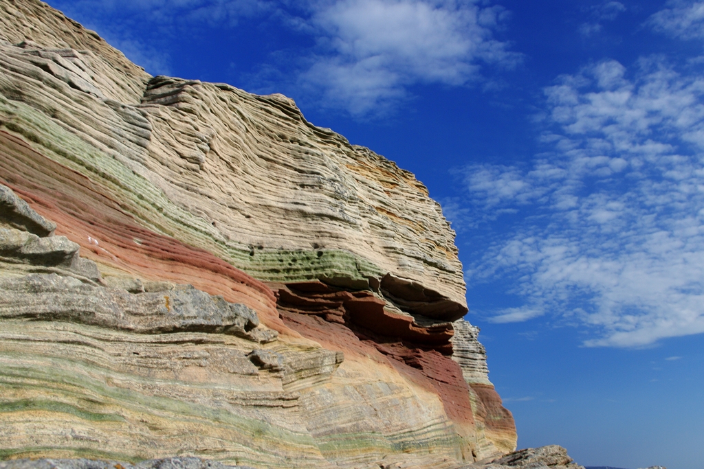
 Take a look up at the cliff itself. Not so long ago, in seaside souvenir shops, you could buy little bottles filled with many coloured layers of sand. This is effectively what we are looking at, only not something from a few decades back, but 230 million years...
 Looking back to the mainland, the surprising thing about West Kirby is how undeveloped it seems, especially given that the centre of Liverpool is only half-an-hour away by a regular train service. This is partly due to planning restrictions, but there has been another force at play – right where we have been walking.
 If you are extremely lucky you may find something even more amazing: The footprint of a very early dinosaur. About the size and shape of a very large man's hand, these have turned up in newly exposed slabs at the base of the cliff. For a long time no one was really sure what the creature looked like, but it was given a name anyway: Chirotheruim (‘chiro’ being Greek for ‘hand’).