Congratulations if you have walked to this spot from the village of Coniston.
Many people access the summit of the Old Man from this car park although the purpose of this road isn’t to make the summit park easier.
This road was originally built to serve a slate quarry, the shape of which is still visible given the bowl shape of the car park. This slate quarry was one of several excavated on the mountainside of the Old Man, so why do we find slate here and why is it important?
Slate is a metamorphic rock. This means a rock which has changed structure. Originally shale, it transformed during volcanic eruptions when the rock was baked by heat and subject to pressures in the earth. Slate is often found throughout mountainous areas in Britain which previously experienced volcanic activity, including Snowdonia in Wales.
The first quarries here date from the twelfth or thirteenth centuries, although there is little evidence of this today. By the 1500s, they were well established with the workings being a kind of silver-grey coloured volcanic slate.
Slate is strong, relatively lightweight, flat and waterproof, making it ideal for use as a roofing material. When the area around Coniston Water was developed, local stone was used for the walls of houses and slate was used to ‘put a roof over people’s heads’.
Directions
Remain on the same spot and turn around so that if the top of the fell is at 12 o’clock face 2 o’clock (or, if you have a compass, face north)
2 Looking north towards Coppermine Valley
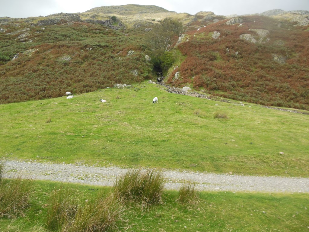
Looking north you can see two ridges of mountains not too far away. Between these ridges is Coppermine Valley. Not surprisingly its name comes from the copper extracted from the rock here.
Like the slate we read about at the last stop, copper was formed as a result of dramatic volcanic activity. During these episodes, mineral deposits rose from deep within the Earth. When the rocks cooled, the softer minerals were weathered away leaving behind the harder, copper-rich minerals. The copper was strong but malleable so it was ideal for making the hulls of ships, weapons, and even for cattle drinking troughs.
Just over the hill in Coppermine Valley are a group of cottages originally built to house workers in the local copper mine.
They are now rented as self-catering cottages, a good example of how the tourist industry uses the area’s industrial past to draw in visitors.
The cottages sit in what would be a picture-postcard setting, if not for the spoil heaps dotted around the valley. When copper was mined only a fraction of what came out of the ground was copper. The rest of the rock was relatively worthless and piled up in a heap next to the mine entrance. These waste tips are still visible today and offer us good clues to the area’s mining past.
As well as the spoil heaps, you might also be able to spot adits. These are horizontal mine entrances. The advantage of this is that the mine can be entered (and the spoils extracted) with relative ease (as opposed to lowering miners via rope); they are well ventilated and can be drained without the need for expensive pumps.
Directions
Leave the quarry car park heading southwest along a gravelled track signed ‘Walna Scar Road’ which passes to the south of the Old Man. The path bends slowly then more sharply to the right before bending at a right angle to the left. Stop here just before the track is briefly tarmacked.
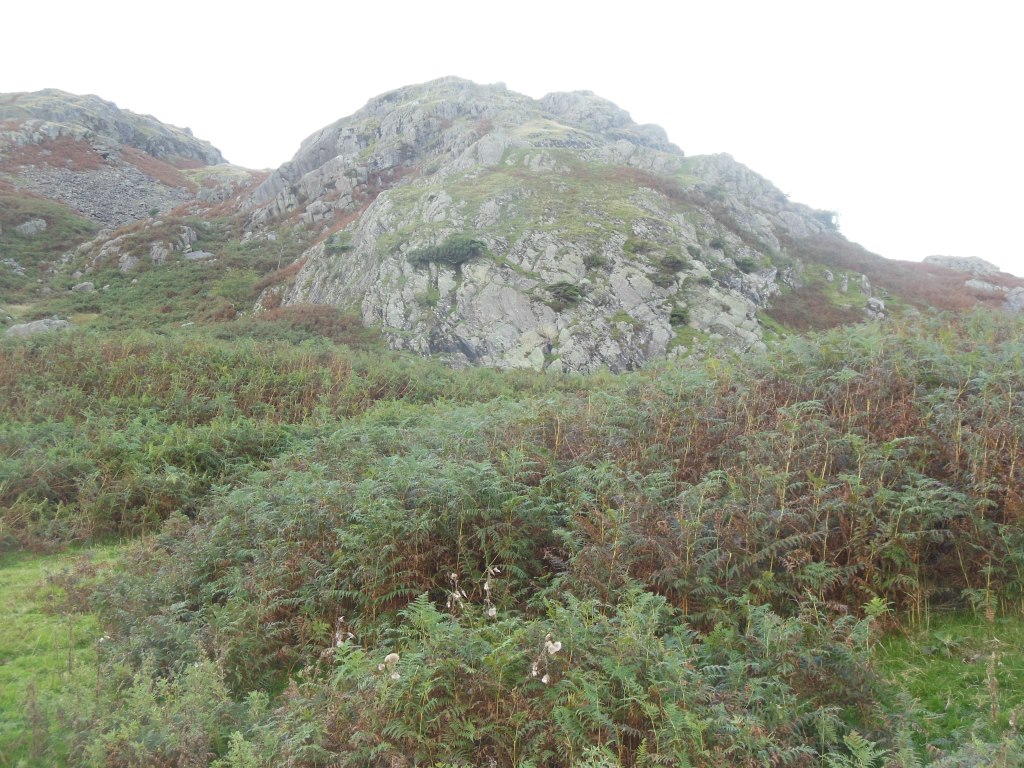
3 Rocky bulge above path
The visible bulge of rock in front of you is evidence of one of the most dramatic periods in the earth’s history. Known as igneous rock, it is made from lava that has cooled and solidified.
When you think of volcanoes you might imagine Krakatoa in Indonesia, Pompeii or Mt Etna in Italy, Hawaii or Iceland, but you probably don’t imagine them in northern England. Yet 450 million years ago, this area was subject to volcanic eruptions on a huge scale.
Few forces in nature are as impressive as a volcanic eruption. From within the rumbling depths of the Earth, hot magma, steam, and even chunks of hot rock are spewed into the air and fast-moving currents of hot gas, rock and ash expelled down the mountainside.
Directions
Continue walking along the gravel path for a further 225m, ignoring the steep path heading up to the right. Stop here.
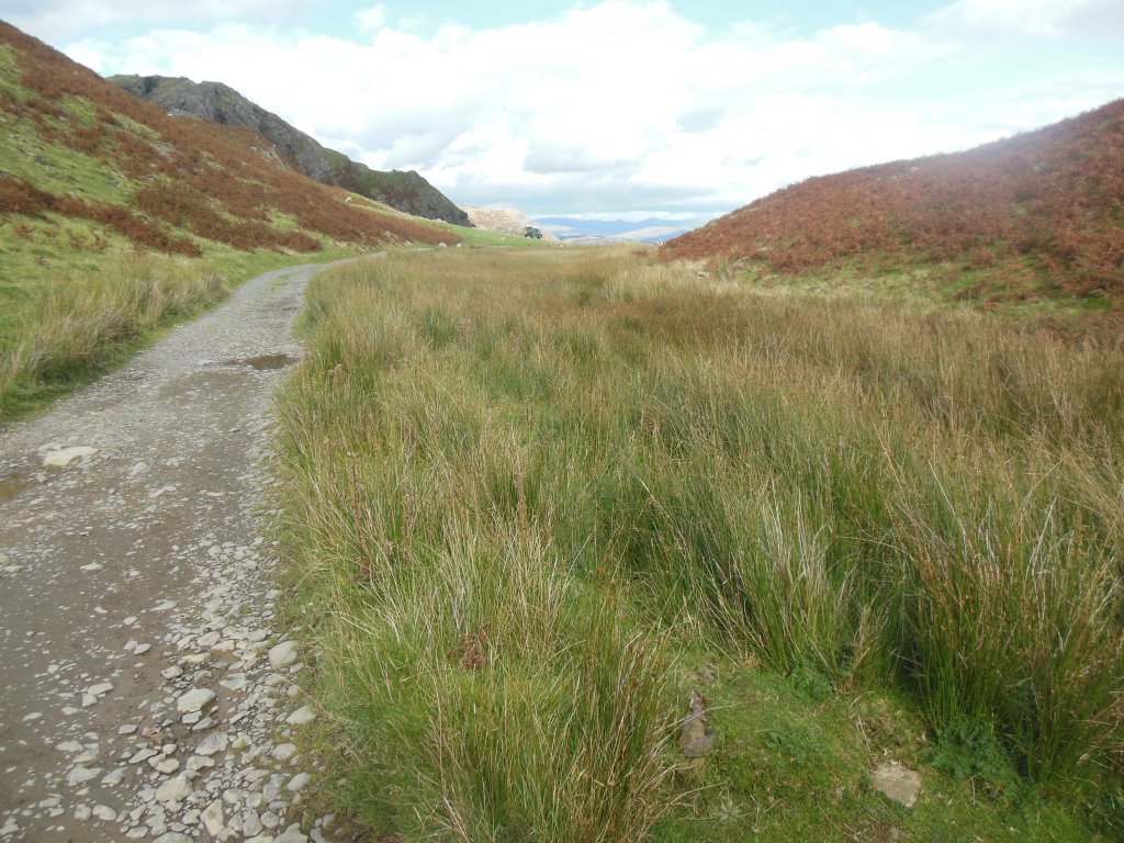
4 Boggy area beside path
The boggy area beside the path grown over with grasses and reeds might not look like much but it tells us another story of how the rocks under our feet have helped shape this dramatic landscape.
Just to the left of the gravel track is peat. Peat is formed from organic materials like plants and trees. If the underlying soils are impermeable (water tight) then the water becomes trapped making the soil boggy or swamp-like. As plants die they fall into this water increasing its organic content. As more plants die the layers of dead material get thicker. This then compresses the underlying layers of plant material and starves them of oxygen. Over many thousands of years, this material becomes so compressed it dries out to leave a rich organic material known as peat.
According to The Wildlife Trust, peatland covers 12% of the UK though 80% is in poor condition. Peat is common in northern, upland areas like the Lake District due to the relatively wet climate and the impermeable nature of the soils.
Peat is also a good carbon store or ‘sink’. This means peat holds carbon, preventing it from being released into the atmosphere where it would form the climate-changing gas carbon dioxide.
Because of its high acidic content, low temperatures and lack of oxygen peat also acts as a preservative. Bodies dating back to 800BC have been found mummified in peat as well as weapons, oak wheels and kegs of millennia old butter!
Directions
Continue a further 200m along the gravel track. The bracken and peat have now given way to grass suitable for sheep grazing. Look out for a triangle shape to the right of the track which, depending upon the time of year has a small stream flowing down the right hand side of it.
5 Alluvial fan
Whilst triangles are not often found in nature, this feature is entirely natural. It’s also evidence of how this landscape was shaped by ice as well as heat. This is an alluvial fan. It formed towards the end of the last Ice Age when, rapid melting of ice and snow from mountain peaks transported vast swathes of material down the mountain side.
These triangle shapes are created when fast flowing water meets with obstacles like mountains, hills, or the steep walls of canyons. As a stream's gradient decreases, it drops coarse-grained material like gravels. This reduces the width of the water’s channel and forces it to change direction. When it changes direction it gradually builds up a slightly mounded conical fan shape. As sediment builds up at the top of the fan, it loses its ability to transport additional material so switches to the left or right. Then, when sediment builds up in this new location, it loses its transportation ability again so switches in the opposite direction, forming the characteristic fan shape.
Such shapes can be found all over the world, commonly occurring in mountains, when glacial and snow melt occurs; and, in deserts, when flash flooding takes place. Alluvial fans are even found on Mars - evidence that there was once liquid water on the red planet billions of years ago.
Directions
Continue a further 500m along the gravel track as it begins to climb gently up-hill. Approximately 75m before you reach an approximately 2.5m high boulder where the path turns slightly to the right, you will notice a narrow grassed path with bracken on either side. Stop here.
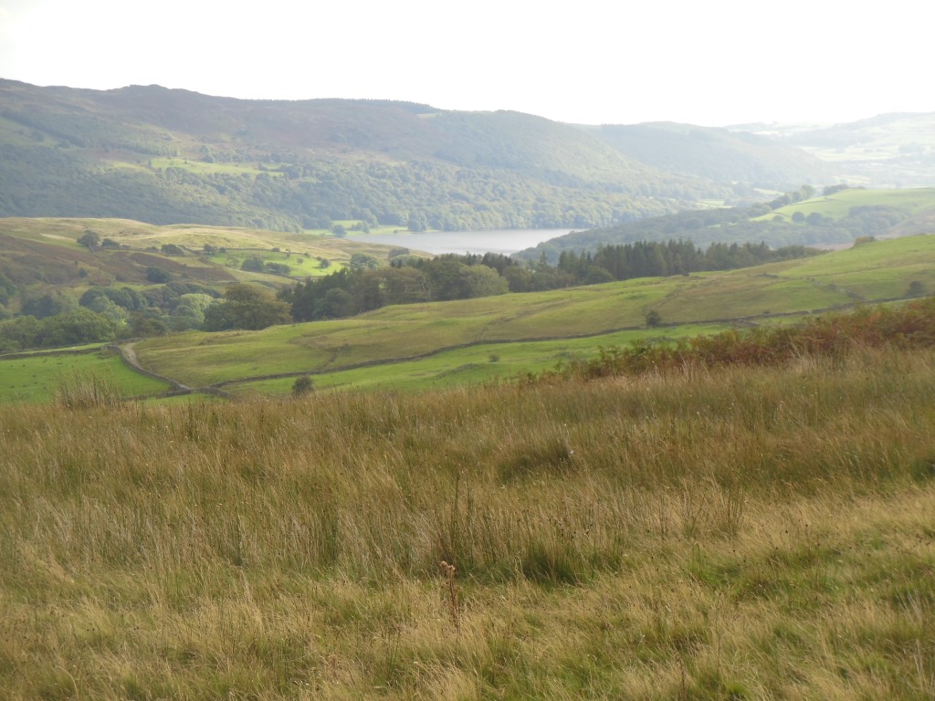
6 Coniston Water view
During the last stretch of the trail you may have noticed a large body of water in the valley bottom in the distance. It is now just out of view. To see more of Coniston Water you will need to climb higher up the Old Man. But for now stay here and imagine yourself 12,000 years back in time. The last glacial period is just ending, the ice sheets that would have once towered over you just a few thousand years ago have now all but melted; so where has all the water gone?
As the glacier crept down the mountainsides it scoured out the softer sedimentary rocks slowly grinding them into clays and silts. When temperatures warmed and the glaciers melted, the water that had been locked up whooshed down into the valley bottoms scouring out more sediment to leave a deep hollow. Eventually the glacial waters came to rest here. Unable to run out at the ends of the valley because of sediment left by earlier glaciers, they filled the scooped out valley bottoms and formed large bodies of water and gave the Lake District its name.
Directions
Take the grass path to the left. Follow this path for a short distance passing a small stone built sheep pen (on your left) heading towards a dry stone wall. Cross over a small dried up stream. Just after the stream, the path rises slightly as you go over the right hand edge of a small mound with a river flowing down the hillside to your right. Follow this path roughly parallel to the river. By now, the gravel path is more obvious. Fence posts can eventually be seen ahead. Walk down the left hand side of the fence posts until a quarry and waterfall come into view.
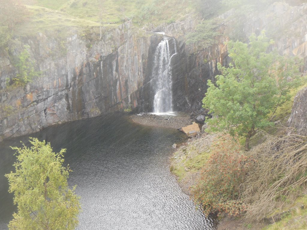
7 Waterfall into quarry
We are now at the final stop of the trail and hopefully you can see and hear the waterfall as it crashes over the edge and into the quarry. Unlike most waterfalls this one was created by human activity.
When miners were quarrying for slate they had to be careful not to dig too close to the many streams which flowed off the Old Man. One of the largest mountainside streams flowed here. Quarrying began on both sides of the stream with the Eddy Scale Quarry worked on the far side of the river and Banishead Quarry on this side. As more slate was dug out the two quarries grew larger and crept closer to each other and to the river.
Eventually, the miners at the Banishead Quarry got too close and a section supporting the riverbank collapsed. Water was diverted into the quarry, flooding it and ending all mining activity here. Fortunately, most of the slate at the bottom had already been mined, and so the water was able to escape through the more permeable sandstone rocks which had underlain it.
This man-made waterfall is an apt point to end our trail. We hope you have enjoyed this short walk around an easy section of the Old Man. In as little as a mile we have spanned the millennia experiencing changes in the landscape brought on by both natural and unnatural causes. From fiery volcanoes to icy glaciers, from swamps to deserts, the Old Man of Coniston offers up many stories if we choose to listen.
Directions
The quickest and safest way back to the start is to retrace your steps following the reverse of the route you have just taken. If you look at a map you will see this is not the most direct route but the more direct route takes you across peat bogs which are not safe to cross.
Your browser is out of date, and unsupported by this website. Please upgrade to the latest version to use this website.
A short mountain walk around the Old Man of Coniston through 450 million years of geological history
Every visitor to the Lakes is struck by their grandeur. Tourists flock here in droves to revel in the drama of the deep valleys (dales) and high mountains (fells).
Although the Old Man of Coniston may seem unassuming in comparison to some of the other higher and better known Cumbrian Fells, its a very popular attraction. But few visitors look beyond Coniston's views to appreciate just how this stunning mountain was formed.
In as little as a mile, this walking trail travels through 460 million years of geographical change and uncovers some of Coniston's many stories.
Follow the trail by clicking on the map pins or downloading the guide below
Coniston Water was the setting for Arthur Ransome’s adventure story Swallows and Amazons with Peel Island standing in for ‘Wild Cat island’ in the book.


.jpg "The rich arable land of the Fens in East Anglia are rich in peat © Natural England, Peter Wakely, Flickr CC")