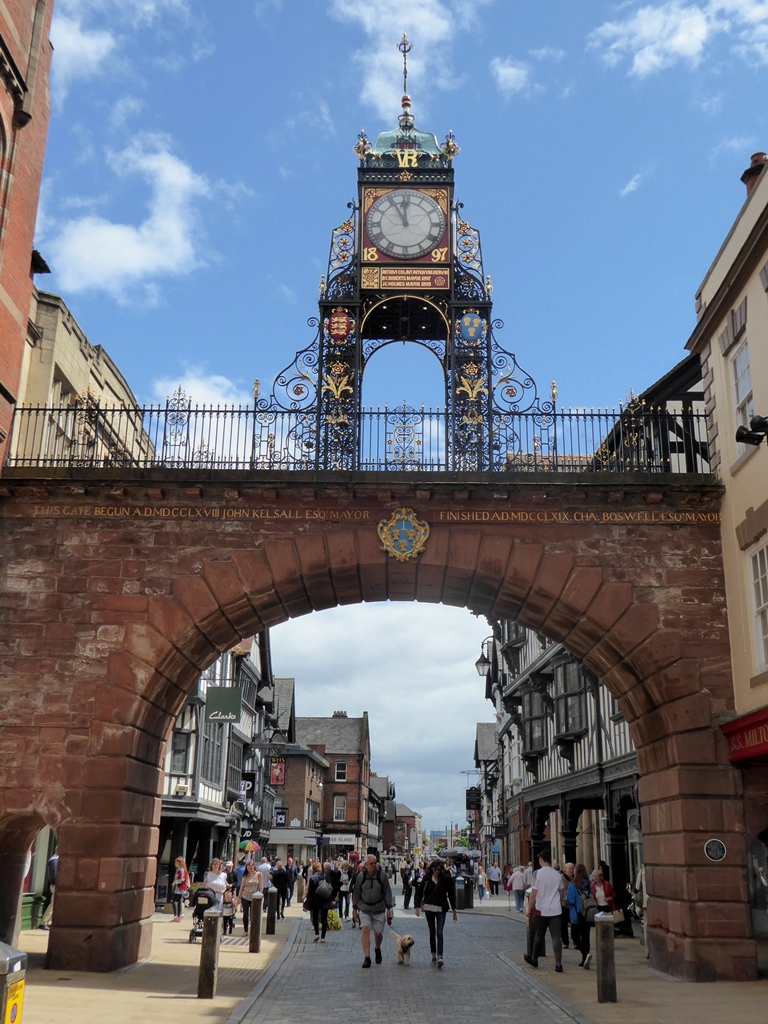
We begin our walk at one of Chester’s most famous landmarks, the Eastgate Clock. Its ornate ironwork and gold lettering appear on countless postcards, websites, and chocolate boxes.
This is said to be the second-most photographed clock in Britain after Big Ben (the Elizabeth Tower in London).
Built in 1899 for Queen Victoria’s Diamond Jubilee, the Eastgate doesn’t seem very Roman. So why start here?
The first thing to notice is the clock’s face. Instead of numbers, the hours are displayed in Roman numerals. It’s a reminder that the Romans still shape our daily lives - in the case of time-keeping, almost literally.
The world’s most common calendar is the Gregorian, adopted in Britain in 1752. It’s a refined version of the ‘Julian calendar’. This Roman calendar was the first to define a year as twelve months totalling 365 days. Our months are still named after Roman gods, except July and August which celebrate Julius Caesar and the Emperor Augustus.
There is another way the Eastgate takes us back to Roman times. Centuries before it was a city, Chester was a Roman fortress. The Eastgate was the main entrance.
The Romans arrived in Britain by ship, probably on the Kent coast, in 43 AD then gradually progressed towards Scotland and Wales. As they advanced across Britain, they built a series of forts to station troops and hold territory. Around 75 AD, the Romans built one here.
Chester’s name comes from ‘castra’, the Latin for ‘fort’ or ‘army camp’. Many other British places called ‘-chester’ and ‘-cester’ have Roman origins. In Roman times though, the fortress here was called Deva Victrix. ‘Victrix’ is Latin for ‘victorious’ while ‘Deva’ may be from ‘dea’ or ‘diva’, the Latin for ‘goddess’.
Deva was a legionary fortress, a military base home to over 5,000 soldiers. It was surrounded by a circuit of walls. Look at a map of Chester and we can still trace Deva’s outline - a rectangle shape with curved corners, like a giant playing card.
Later on, we’ll explore the city walls in more detail and enjoy the view from the top of the Eastgate. For now, let’s go into the fortress.
With your back to the Eastgate and with the Grosvenor Hotel on your left, continue along Eastgate Street. Take time to notice the historic buildings lining both sides of the road. Pass St Werbergh Street on the right (leading to Chester Cathedral). At the junction with Northgate Street on the right, continue ahead a short distance to a stone column outside St Peter’s Church. Stop beside the column.
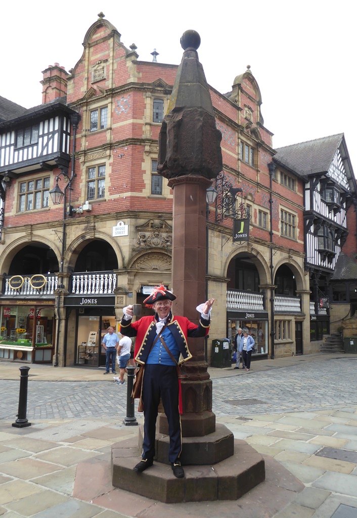
2 The Cross
This is ‘The Cross’, a name used for the column beside us and the crossroads. The column marks the centre of Chester. In summer the town crier makes public announcements here at midday, a tradition that goes back to the medieval era, when most people couldn’t read or write. Listen carefully or you might get locked up in the pillory!
The Cross dates from the fourteenth century. So do many of the surrounding black and white timber-frame buildings. These are the Rows, possibly Britain’s most unusual shopping centre.
Unique to Chester, the Rows have balconied arcades of shops above the ones at street-level. Some of the shopfronts are Victorian but many of the interiors are centuries older. Stories say their layout developed from being built upon collapsed Roman buildings. There are Roman ruins in some of the basements.
We can trace more Roman geography in the street layout. From the Cross, look back towards the Eastgate. Notice we’ve climbed slightly uphill and our route was very straight. We’ve been following the course of a Roman road.
The Cross is where four Roman roads meet - Eastgate Street, Northgate Street, Watergate Street and Bridge Street. As their names suggest, they led to four gates in the fortress walls. Around the Cross are street signs with their original titles.
Northgate Street, to our left behind St Peter’s Church, was the Via Decumana (‘back street’). Opposite, the downhill slope of Bridge Street was the Via Principia, a name we’ll explore at the next stop.
Eastgate and Watergate Streets made up the Via Principalis, the ‘main street’ through Deva. In Roman times, this road led to two other fortresses, Mamucium (Manchester) and Eboracum (York). Part of the route lives on today as the A56.
Many other long-distance roads have Roman origins. The A2 and A5 follow the course of Watling Street, a Roman road from Dover to Wroxeter in Shropshire. The A46 meanwhile is part of the Fosse Way, built between the forts at Lincoln and Leicester.
The survival of these routes - and their famous straightness - reveals great expertise. The Romans were skilled surveyors. They created direct roads between fortresses using the lay of the land. The Romans’ relationship with the landscape still shapes Britain today.
The Rows c1895, Wikimedia Commons (CCL) Click on the picture to enlarge
Directions
With St Peter’s Church on your left, look back towards the Eastgate clock tower again. Pass the church and turn left into Northgate Street. Continue uphill past a row of buildings on the left with carved wooden pillars. At the end of this row, turn left. Go through a narrow stone arch beside The Dublin Packet pub. Stop outside the remains of the Roman Strongroom.
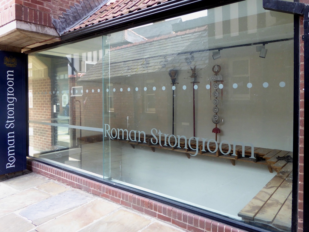
3 The Roman Strongroom
Here is our first glimpse of the actual Roman fortress. A variety of its remains survive, although some look more spectacular than others. At first sight the Strongroom might seem rather dull, a few bits of stone below our feet. But these sunken ruins are highly significant.
Covering 56 acres, Deva was the largest Roman fortress in Britain. We are now in its spiritual and financial heart. Take time to read the information board to the right. Notice the map which shows where we are, both today and in Roman times.
From Africa to the Middle East, Roman legionary fortresses were built with the same basic plan - a rectangle of walls, gates in each side, and main roads that met in the middle. Within were barracks for the soldiers, storerooms, baths, and the ‘principia’.
The ‘principia’ (Latin for ‘primary buildings’) was the military and religious headquarters. The largest fortress building, it was centrally located for security and guarded at all times. The Strongroom was the underground vault that held secular and sacred treasures.
More of Deva’s principia survives nearby. Around the corner from the Strongroom, some of the column bases have been placed outside a pub. On the way to the next stop, we’ll pass 45 Northgate Street, where a see-through floor tile reveals more of the principia’s remains in the basement.
It’s fitting that we can see into the Strongroom as the Romans invaded Britain partly for financial gain. Throughout the Roman Empire there was high demand for metals and minerals, including gold, silver, copper, tin, lead, and salt.
Britain had great supplies of these natural resources and had grown wealthy by trading them. By invading, the Romans could access and run this valuable trade.
They controlled the economy further by introducing Britain’s first taxes and national currency. Some tribes had minted coins as local status symbols but the Roman concept of using coins to buy goods soon spread nationwide.
The Romans remain central to Chester’s fortunes. The city’s Roman heritage attracts visitors all year round, from archaeologists and academics to tourists and school groups.
To see more of the principia, go back through the arch and turn left onto Northgate Street. Pass the Town Hall and Visitor Centre on the left then stop outside The Coach House Inn. The column bases are beside the outdoor seating area.
When you are ready, retrace your steps back down Northgate Street. Number 45 (currently a coffee shop) is on the right hand side, in the row of shops with carved wooden columns. The clear floor tile is just to the right of the shop entrance.
Next, continue downhill to The Cross again. With your back to St Peter’s Church, go ahead along the left hand side of Bridge Street. Follow it all the way downhill. Use the traffic lights to cross the junction with Pepper Street and at the bottom of Bridge Street is the arch of the Bridge Gate. Go through it and onto the bridge spanning the river. Stop about halfway across.
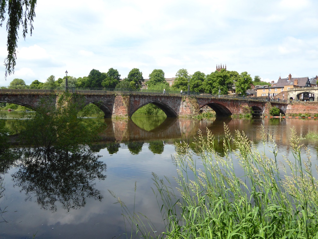
4 View from the Old Dee Bridge
The Old Dee Bridge dates from the 1380s and stands on the site of an earlier Roman one. Take time to enjoy the views. To our left are some of the city walls and the Groves, a pleasant tree-lined walkway beside the River Dee.
So far we’ve explored how the Romans settled in Chester. At this spot, the first bridgeable point of the Dee, we can explore why.
Notice the city is on high ground, with the Dee winding below us like a moat. This location was ideal for a fortress. The ridge and the river were natural defences that allowed the Romans to take territory from a Welsh tribe, the Brigantes. The Dee still forms part of today’s Welsh-English border.
Besides keeping people out, the river let people in. The Dee flows through Chester from the mountains of Snowdonia before entering the Irish Sea at Liverpool Bay. This coastal estuary meant ships from throughout the Roman Empire could bring soldiers and supplies into the fortress.
Similarly, the Romans’ first British capital, Camulodunum (Colchester), was founded for its strategic access to the Essex Estuary. Other estuary forts included Isca Dumnoniorum (Exeter), Pons Aelius (Newcastle), Venta Bulgarum (Winchester), and Londinium (London).
Beyond military might, rivers were central to daily life. They provided water for drinking, cooking, cleaning, and bathing. The Romans were plumbing pioneers, introducing bathrooms, sewers, drains and aqueducts. Deva’s baths, fed by the Dee, were on nearby Bridge Street.
Without the Dee, Chester wouldn’t exist. Rivers though were just one way that the Romans used Britain’s natural landscapes. For example, Hadrian’s Wall was built upon a natural tectonic cliff spanning the narrowest part of the country. The city of Bath exploited our only warm water springs, while the Mendips and the Weald were mined for lead and iron.
Overall Britain was usefully located. Our island was a stepping stone from northern Europe, ideally placed for expanding the Roman Empire. And Chester’s fortress became the western front.
This has caused great debate. Were Deva’s site and size clues to a wider role? Was this the launch site for an abandoned invasion of Ireland? Was Chester intended to be the Roman capital of Britain? We’ll never know for sure.
The Old Dee Bridge carries a single lane of traffic at a time, controlled by lights at both ends. Keep the road on your right and continue across the river. When it is safe to do so, use the lights to cross the road and head towards The Ship Inn pub. Pass the pub and go into the park. Follow the footpath ahead, past a playground, and continue a short distance uphill to a large rock on the left. Stop in front of the rock at what looks like a stone porch.
5 Minerva shrine, Edgar's Field
Tucked away in a small park, this rock carving is a shrine to the goddess Minerva. It’s the only Roman religious shrine in Europe still in its original location. Today it offers an insight into Roman Britain’s religious culture.
The Romans were ‘polytheistic’, meaning they worshipped many gods and goddesses. They adopted local gods and encouraged the Britons to adopt theirs.
The shrine hints at a wider process of ‘Romanisation’. Besides religion, the Romans urged locals to adopt their clothing, diet and language.
Lashed by 2,000 years of wind and rain, Minerva’s outline is hard to trace. Look closely though and we might make her out.
She is standing and holding a spear, while her other hand carries a shield. An owl perches on her shoulder. Minerva was the goddess of wisdom and of soldiers, hence her weapons and feathered friend. She was also the ‘patron’ of trades, including quarrying. This park is the remains of a Roman quarry, one of several surrounding Chester.
With Minerva on your left, go around the side of the rock. Look at the swirling red, yellow, and brown stripes. Touch the surface too. It should feel slightly rough and crumbly. We are looking at Chester’s foundations - sandstone.
Sandstone is ideal for making walls and buildings. It’s durable but ‘soft’ enough to cut with basic tools. Much of Deva fortress was built using this local stone - its abundance was another reason the Romans settled here.
On our way the next stop look at the river wall and the bridge. They too are made of the local sandstone.
With the shrine on your left, re-join the footpath. Go over a small hill then turn sharp right onto another footpath beside the river. Follow this path back to The Ship Inn. Carefully cross the road again and go back over the bridge.
At the end of the bridge, use the traffic lights to turn left before the Bridge Gate. With the river on your left pass Chester University on your right. Immediately after the University building, join the raised path with a wooden fence on the right. You are now on the city walls.
Follow the walls past Chester Castle and a pair of car parks. When you reach a road, continue ahead at the traffic lights and go towards Chester Racecourse. Keep the course on your left and go up to a metal viewing platform with a set of binoculars. Stop here and look over the course.
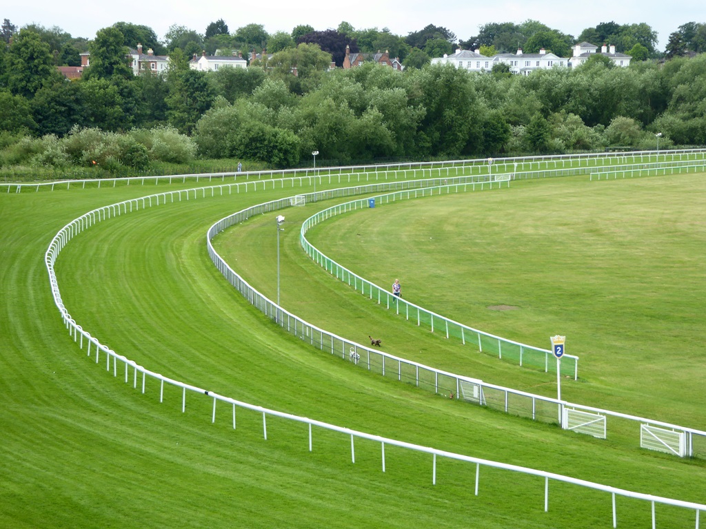
6 The Roodee (Chester Racecourse)
Known as the Roodee, this is Britain’s oldest racecourse. Chester’s mayor, Sir Henry Gee, granted permission for racing here in 1539 and racehorses have been nicknamed ‘gee-gees’ ever since.
This stretch of the city walls is a great place to watch the action. Take time to read the information boards. As they highlight, instead of fleet-footed steeds this place once welcomed fleets of ships.
Today Chester is ten miles inland but 2,000 years ago the Roodee was the site of a busy Roman port. The first Roman legion posted at Deva, the Legio II Adiutrix (’Rescuer Second Legion’) was a division of the navy. They were stationed here to build a harbour.
Excavations under the grandstand have uncovered a wooden Roman jetty. Behind the car park to our right meanwhile is the ‘Roman Quay’. This stone wall is possibly the remains of a dock or flood barrier.
Also look on the racecourse for the stump of a cross. The name ‘Roodee’ is Saxon for ‘island of the cross’ (‘rood’ meant ‘cross’ while ‘ey’ or ‘ee’ meant ‘island’).
By early medieval times this area had become a boggy marsh of tidal islands. Today the land is firm enough for cheering crowds and thundering horses. So what happened to the port?
Some rivers that meet the sea are prone to filling with mud, or ‘silting up’. Silt is very fine material washed inland by tidal water. Over time, it builds up and reduces the river’s channel.
When the Romans left Britain, around 410 AD, Deva’s port had become too small for large ships. Although experts at using the natural landscape, they couldn’t defeat the forces of nature.
If you have time, go down the steps towards the car park to see the Roman Quay. Return to the viewing platform and with the racecourse on your left, keep following the city walls. Pass the grandstand and go over the Watergate (above Watergate Street) where you will find another information board.
When you are ready, continue along the city walls. Landmarks along the way include the Water Tower and Pemberton’s Parlour viewing tower. Shortly afterwards the walls cross over a dual carriageway and then reach the Northgate.
*Diversion until autumn 2018* - The Northgate is currently closed for structural repairs. To continue the walk, go down the steps to the right of the wall - they are a little steep so take your time. With the wall on your left, continue along Water Tower Street and up to the Northgate.
At the Northgate, turn left. Use the pedestrian crossing outside the Blue Coat Hospital to go over Northgate Street. Turn right and stop by a set of benches beside some metal railings.
7 View of the Roman Walls, Northgate Bridge
Chester’s city walls create a scenic two-mile loop around the oldest parts of the city. So far we’ve enjoyed the views from some of the best-preserved sections.
There was something we couldn’t see however - the walls themselves. This bridge is one of the best places to look at them. Peer through the railings and notice how the wall changes.
At the top we can see small neat bricks. Then, below where a cornice or shelf spans the wall, are larger blocks. At the bottom, the Shropshire Union Canal cuts through the natural sandstone.
The middle section of larger blocks is Roman. Like all Roman fortresses, Deva was built as quickly as possible. The original walls were made of earth with a wooden fence on top. In 102 AD a new legion was posted here (the Legio XX Valeria Victrix or ‘Twentieth Victorious Valeria Legion’). They strengthened Deva by rebuilding it in stone.
Look closely at the Roman section. Stone bricks were another Roman innovation. Some of the examples here are almost a metre across. They were hand cut from the local quarries using axes and chisels, probably by slaves and prisoners.
Besides defence, the walls were an intimidating symbol of strength. Soldiers patrolled them and guarded the gates. Legends say one still does. A ghostly Roman legionnaire has often been spotted walking along the part we’re going to follow…
After the Romans abandoned the fortress, many of the buildings were demolished and the stone reused. The walls, though, were largely maintained. One set of repairs even used Roman tombstones.
During the English Civil War (1642-1651), the walls made Chester strategically important. Sections were damaged in fierce fighting. From the 1720s they were rebuilt, this time for pleasure. The top stretch we can see here is part of a Georgian promenade.
Despite everything they’ve faced, Chester’s circuit of Roman walls are the most complete in Britain. Their survival is another testament to the Romans’ skill and a reminder of their enduring legacy.
Deva fortress walls overlaid on a modern Ordnance Survey Street Map of Chester Click on the picture to enlarge
Directions
Go back onto the city walls. There is a set of steps inside the Northgate and a flight of steps to the right of the bridge. These are quite steep, so again take your time.
Once on the walls, continue with the canal below on your left. Pass the King Charles Tower then go through the grounds of Chester Cathedral. If you’re lucky you may see a falconry display on the lawn! Past the Cathedral, go up the steps to the top of the Eastgate. Here you can enjoy the views from the clock tower.
When you are ready, keep following the walls. Pass a modern car park on the right and continue to the Newgate. There are a lot of Roman remains visible from here, including the Angle Tower, Amphitheatre and Roman Gardens.
Continue ahead through the Newgate, then immediately take the set of steps on the left down to street level. At the bottom, turn sharp right and go under the gate. Carefully cross the end of the road (Souters Lane) and continue ahead into the Roman Amphitheatre. Stop at the first information board.
8 Chester Roman Amphitheatre
Thanks largely to Hollywood, one of the most evocative images of the Roman world is gladiators stepping into an arena and fighting to the death before a baying crowd.
Today traffic trundles past the place where such blood was spilt in Chester.
Chester’s amphitheatre dates from the third century but it was only found in 1929, when the curved outer wall was discovered during some roadworks. The remains were finally unearthed in the 1960s.
Across the road, next to the Newgate, notice the remains of the Angle Tower. This tower protected a corner of the fortress walls. The amphitheatre was built just outside the fortress and illustrates the transition from military camp to civilian town. A settlement grew beside the fortress when locals began trading with the soldiers.
This isn’t the only Roman amphitheatre in Britain – but it is the largest. The arena spans almost 2,500 metres (about half a football pitch) while the surrounding banks of seats held 7,000 people. It may feel smaller because we can only see half of it. The rest lies buried under listed buildings, which cannot be demolished.
Access is a recurring issue with Britain’s Roman heritage, especially in towns and cities where we face a difficult balance between preserving the past and serving the present. The amphitheatre raises another issue. Not all Roman legacies deserve celebrating.
In many ways Roman society was advanced and cultured. But in others it was backward and barbaric. For some people, life became worse under Roman rule. Tribes were evicted from their land. People were forced into slavery and to pay high taxes. ‘Rebellion’ usually meant death in battle or the death penalty.
For a compelling glimpse of the past, go into the arena. Try to imagine the sounds and sights.
Also look in the floor for a block with a hoop on it. This is a tethering stone. A bear, bull, stag - or a person - would have been tied to it, to fight or be executed.
Though the amphitheatre is only partly visible, there is still plenty to see. Take time to explore the site. There are several information boards, plus a model showing what the complete building may have looked like.
When you are ready, return to the way you came in. Carefully cross Souters Lane again and immediately turn left into the Roman Gardens. Stop by the circular mosaic in the ground.
9 The Roman Gardens
The Roman Gardens were first laid out for the 1951 Festival of Britain then remodelled in 2000 for the millennium. This tranquil space gathers together various Roman relics that have been found throughout the city.
Among these fragments are more columns from the principia. There are also some later reproductions, including a ‘hypocaust’ - a Roman underfloor heating system - and this mosaic.
Installed in 2005 by the Chester Civic Trust, the mosiac celebrates Roman gardening. The Romans were keen gardeners, though only the very wealthy would have had one like this at their villa. Smaller kitchen gardens were used to grow medicines and food.
As a result, the Romans had a great effect on our national diet. Foods that the Romans brought into Britain include apples, pears, peas, plums, grapes, cabbages, carrots, garlic, onions, celery, turnips, nettles, mustard and walnuts. They also gave us rabbits and domestic cats.
Wander around the plant and flower beds here to see which ones you can identify. Also notice the layout. The central walkway has an S-shaped path looping across it.
The gardens are modelled upon the symbol of Aesculapius, the Roman god of medicine. His symbol, a snake coiling around a staff, still appears in hospitals and on ambulances.
The Roman Gardens bring together many of the topics we’ve explored on our walk. They were created on the site of another Roman quarry and today provide a shortcut to the River Dee. Beside them is another stretch of the fortress wall, including a section that was rebuilt after a siege in the Civil War.
The gardens are a reminder that the Romans built a fortress here for the natural location and natural resources of water and stone. Throughout Britain, the Romans used the existing landscape to create a new one, one that changed our nation’s appearance, character and culture.
We often think of the Romans as a chapter in history. The story of Chester shows they remain vital to Britain’s geography.
Take time to explore the gardens. When you are ready, you can reach the riverside by following the path all the way to the end. You will emerge at the Groves, with the Old Dee Bridge on your right.
To return to the city centre, leave the gardens by the way you came in and turn left onto Pepper Street. At the end you will reach the junction with Bridge Street. Use the traffic lights here to turn right and follow Bridge Street uphill to The Cross.
Your browser is out of date, and unsupported by this website. Please upgrade to the latest version to use this website.
What have the Romans ever done for us? Thanks to Monty Python the question has become a joke, or at least something we take for granted. Yet from their invasion in 43 AD to their departure around 400 years later, the Romans transformed Britain.
Much of their legacy is still with us today, from food and drink to religion and roads. The Romans’ greatest impact though was founding many of our towns and cities.
Chester was one of Britain’s most important Roman towns. This short walk explores why the Romans settled here - and how they still shape our lives today.
Follow the trail by clicking on the map pins or downloading the guides below
Chester is said to be haunted by the ghost of a Roman legionnaire. After abandoning his guard duty to meet his local lover, he was killed by an angry mob - and now patrols the city walls as punishment!


 The Old Dee Bridge dates from the 1380s and stands on the site of an earlier Roman one. Take time to enjoy the views. To our left are some of the city walls and the Groves, a pleasant tree-lined walkway beside the River Dee.
 Tucked away in a small park, this rock carving is a shrine to the goddess Minerva. It’s the only Roman religious shrine in Europe still in its original location. Today it offers an insight into Roman Britain’s religious culture.

 Excavations under the grandstand have uncovered a wooden Roman jetty. Behind the car park to our right meanwhile is the ‘Roman Quay’. This stone wall is possibly the remains of a dock or flood barrier.
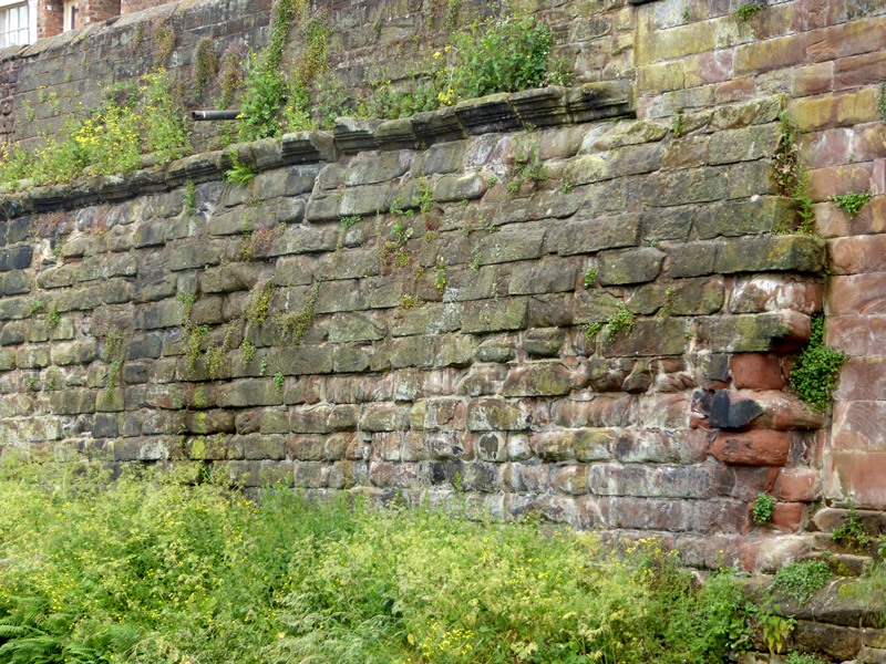


 Also look in the floor for a block with a hoop on it. This is a tethering stone. A bear, bull, stag - or a person - would have been tied to it, to fight or be executed.
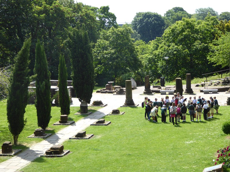
 The Roman Gardens were first laid out for the 1951 Festival of Britain then remodelled in 2000 for the millennium. This tranquil space gathers together various Roman relics that have been found throughout the city.
 We often think of the Romans as a chapter in history. The story of Chester shows they remain vital to Britain’s geography.