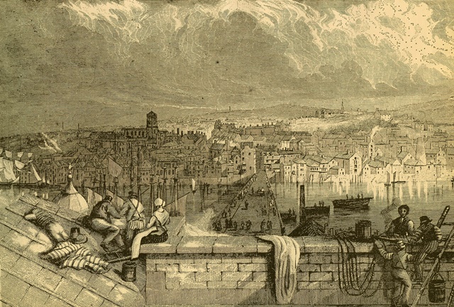
Gateshead lies on the south bank of the River Tyne. There has been a settlement here since the Roman period thanks in part to its interesting topography. From the quayside, the land rises up sharply and from the highest points there are some wonderful views across the river.
Many people mistakenly think Gateshead is part of the larger city on the opposite river bank, Newcastle-upon-Tyne. In fact, they are distinct and separate places. Newcastle, however, often overshadows Gateshead - while Newcastle is beloved of architectural critics, Gateshead regularly appears in lists of Britain’s most undesirable places to live.
As far back as 1934 the author and broadcaster J B Priestley gave a derisory account of Gateshead in his travel book ‘English Journey’. He wrote: “The whole town appeared to have been planned by an enemy of the human race”. More recently, it was reported that a woman was refused a UK Visa because immigration authorities deemed her plan to visit Gateshead for a holiday was “not credible”.
Following the demise of traditional industries in the twentieth century, Gateshead Council has experimented with different ways to regenerate the town. On this short walk, we will find out about garden festivals, public art, flagship buildings, housing and the problem of industrial ruins.
This walk was created by Angela Connelly, a researcher from Manchester University.
Angela: “My background is in urban planning and architecture; I am particularly interested in the cultural values of buildings and the types of social connections that take place in them.
I am also very interested in trying to understand how cities change over time and what this means for the people who use or used them. I created this walk to help me understand the wider context of one of the sites on the route – Dunston Staithes – which I have recently spent some time investigating.
By exploring Gateshead’s regeneration over successive decades, we will uncover the wider story of urban regeneration in the UK - and in a much more tactile way than simply reading about it in books. I hope that you enjoy the walk.”
Start by facing the entrance to the BALTIC Centre with the river on your left.
2 An artistic statement
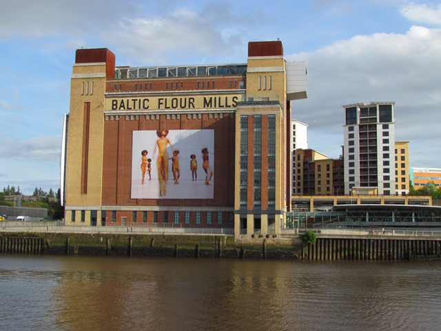
We begin at one of the buildings that symbolises Gateshead’s approach to culture-led regeneration - the BALTIC Centre for Contemporary Art. The building was originally a flour mill, built in 1950 for Ranks of Hovis bread fame. By the late 1980s the building was derelict and in 1992 Gateshead Council came up with the idea to convert it into an arts space.
Following an international design competition, won two years later by a young architect called Dominic Williams, the £46 million development went ahead. The Arts Council of England’s National Lottery fund backed the project with £33.4 million for building costs. They also provided an initial £1.5 million per year over five years for running costs.
The BALTIC houses five major galleries, an art performance space for up to 300 people, a cinema, artists’ studios and education workshops. It opened in 2002 and attracted one million visitors in the first year.
The BALTIC has created an estimated 500 jobs and draws £5 million annually into the local economy. It is an explicit example of the focus on the arts and culture in regeneration. In fact, a piece of public art has become an icon of the new Northeast - Anthony Gormley’s sculpture the ‘Angel of the North’. It is situated a short distance from here on the site of the former Teams Colliery and marks the entry point to Gateshead.
Such culture-led regeneration has been strong in the UK since the 1980s. Before then regeneration focussed on using new industries and retail to revitalise an area. Glasgow’s success in 1990 as the first European Capital of Culture demonstrated how the arts, architecture and music could help to create jobs and prosperity.
With the BALTIC behind you head towards the curving white bridge. This is the Gateshead Millennium Bridge. Continue halfway across it then stop and look down the river towards the other bridges.
3 Bridges and tunnels
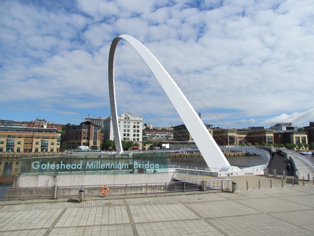
The beautifully curved Gateshead Millennium Bridge was part of the same regeneration programme as the BALTIC Centre. Designed by Wilkinson Eyre Architects, it was the world’s first tilting bridge.
So that boats can pass underneath, it opens and shuts by tilting through 40 degrees. Its shape (minus the tilt) has been copied across the UK, from the Squinty Bridge over the River Clyde in Glasgow to the Millennium Bridge in York.
Seven bridges over the Tyne link Gateshead and Newcastle. Look along the river and there is a great view of them - including the curved Tyne Bridge, the red and white Swing Bridge and the square High Level Bridge. You might wonder why the river required yet another bridge!
The intention was to link Gateshead to Newcastle both symbolically and physically. This was also the first of the Tyne bridges designed solely for pedestrians and cyclists rather than motor vehicles, trains or trams. This idea that an urban space needs reclaiming for pedestrians is actually relatively recent and comes under the banner of ‘sustainability’.
After the Second World War, many of Britain’s towns and cities were comprehensively redeveloped. Besides new homes, their redesigns included easy motor vehicle access via new motorways and bypasses. In Newcastle, plans in the 1960s for an extensive motorway network were much larger than the routes eventually built. Such layouts were later criticised for giving priority to the car at the expense of people.
Pedestrians in Newcastle, for example, have difficulty crossing Pilgrim Street because of a large roundabout. Walkers must use a system of underpasses to get from the city centre to the Quayside – which is complicated and does not feel very safe at night. Walking around Gateshead’s Quayside now, you can appreciate just how different it might have been without the access for cyclists and pedestrians.
Retrace your steps to the Quayside. With the BALTIC on your left, go up the steps or the ramps then turn right towards the curved glass building, Sage Gateshead. Stop at the bus stop for a good view of it.
4 An iconic landmark
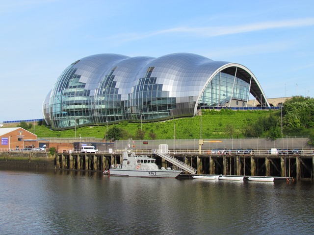
The unusual, shell-like Sage Gateshead was designed by the acclaimed architect Sir Norman Foster and opened in 2004. It is primarily a music venue, and includes performance spaces, bars, restaurants and rehearsal rooms.
A number of music groups use it, such as the Northern Sinfonia and Folkworks, and it has a Music Education Centre. The Sage is the third major example here on the Quayside of land reclaimed for culture-led regeneration.
The building is located on Rector’s Fields, a plot associated with the nearby St Mary’s Church (which is now a local heritage centre). In the early twentieth century, there were many engineering works here and two large gasometers. After the Second World War, however, industrial decline meant that the site went out of use. It became a scrapyard, a travellers’ site and later derelict.
Iconic structures like the Sage are undeniably spectacular. But they have been criticised for creating something known as the ‘Bilbao Effect’. The Spanish city of Bilbao was reborn as a tourist destination after architect Frank Gehry designed the new Guggenheim Museum there. Tourists flocked to see the distinctive building perhaps more than what was inside it.
Many other cities have similarly tried to use architecture to attract tourists. Sometimes it does not work very well. There are landmark buildings that do not seem to fit with their surroundings. There have been criticisms that such buildings result in regeneration eroding local distinctiveness and identity. Although a matter of personal taste, suggested examples include the Selfridges Building in Birmingham or the Blade Building in Reading.
The Sage could easily fall into that trap but there have been conscious attempts to make the building part of the surrounding community. The carefully designed events programme aims to have broad appeal to the people of Gateshead, rather than to an exclusive or tourist audience.
The consensus is that, unlike many other iconic buildings, the Sage actually works whether you use it or simply admire it from the other side of the river. What do you think of the building?
With the Sage on your left, continue along the left pavement. Pass the Tyne Bridge then cross the junction using both sets of traffic lights. Continue downhill onto Pipewellgate. Just after you pass under the High Level Bridge there is a piece of public art on your left. Stop beside it.
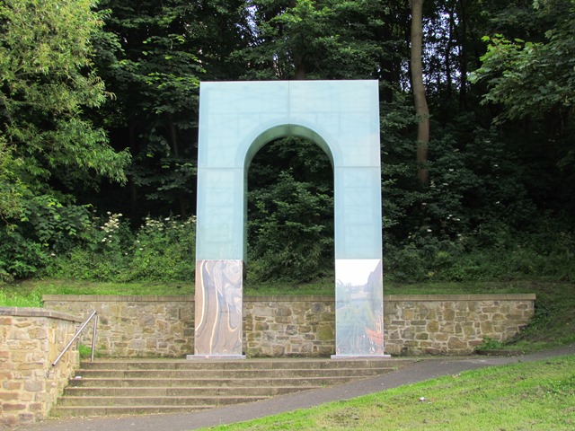
5 Rise and fall
This is Riverside Park, an open space that has been another part of Gateshead’s culture-led regeneration strategy and its now home to a series of sculptures. This arched structure called ‘Rise and Fall’ was created in 2007 by the artist Lulu Quinn. It is one of a series of public art pieces commissioned by Gateshead Council.
Gateshead Council has championed the role of public art in wider economic and environmental regeneration since the 1980s. Their approach is to try to ensure that the art pieces make sense within the areas they are placed. Often this means that any new developments – whether a retail park or a housing estate – contain some form of public art. The artworks are designed to help integrate new buildings into the existing urban fabric.
Public art can also create a sense of local identity. The arch of ‘Rise and Fall’ is intended to be a reference to the industrial heritage of the River Tyne - in particular, the High Level Bridge up above. It also reflects the buildings across the river and acts as an entry and meeting point for the park.
Stay here for long enough and you will see that the sculpture lights up. Low energy LED lights come on at random to give the illusion that the structure is falling down and building itself back up again. Perhaps this is saying something about the way that cities and their buildings similarly change with the ebb and flow of time.
Continue along the pavement nearest the river and follow it up to a car park. Turn right and stop by a stone bench in the corner with ‘Gateshead’ written on it. Look across the car park to the trees.
6 Pipe clearing
Riverside Park was created on an area of Gateshead called Pipewellgate. It is difficult to imagine now but Pipewellgate was a busy working, living and trading site - especially during the nineteenth century. Now only the road name remains.
At first Pipewellgate thrived on being close to the river. However, as Gateshead expanded many transport routes bypassed it - you will see that many bridges cross over the road here but do not connect to it. This was because the bridges were designed to give passage from higher ground in Gateshead.
Land prices in Pipewellgate decreased and those who could afford to moved out. Poorer people moved in and the area’s cramped location led to heavy overcrowding, poor housing conditions and health problems. The area became a slum. By the 1930s, the established approach to slums was to clear them. The local authority reclaimed the land and Pipewellgate was demolished.
England experienced slum clearance programmes early because it was one of the first countries to industrialise. Despite good intentions, such clearance schemes had mixed results. Through their focus on public health, clearances tended to break up communities and sometimes neglected an area’s strong social connections – things that can be quite hard to recreate in new areas.
There are now slum clearances throughout the world and it is interesting to think about current approaches to the problems of overcrowding, poor health and poor sanitation. Clearance schemes in Britain, with areas so readily demolished and rebuilt elsewhere, may seem unlikely today. This is still happening however - as we shall encounter later.
With the river on your right, pass the car park and continue along the riverside path. Stop when you reach the blue painted Queen Elizabeth II Metro Bridge. Look across the river.
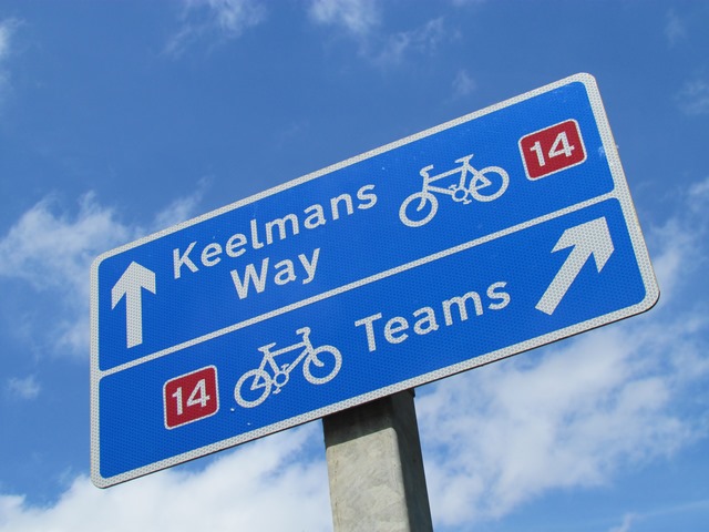
7 River cycles
The Tyne is a relatively shallow river. In the 1500s it was described as a “tortuous shallow stream full of sand”. Work was carried out to improve navigation for ships but after the low-level bridges were built, the Tyne became difficult to use again.
Colliers - the large sea vessels that exported coal from the Tyne - were too big to travel up to Gateshead and Newcastle. As a result, flatter-bottomed boats called keels took coal from the shore to the colliers waiting downstream. Each keel had a crew of four, called keelmen.
Keelmen were central to the growth of the Northeast’s coal trade. Their job was dirty and dangerous. It was also seasonal; many keelmen came from the Scottish Borders and returned home in the winter. Keelmen had their own unique culture and uniform: a blue jacket, yellow waistcoat, bellbottom trousers and blue bonnet.
Developments in coal transportation, including waggon routes from coalmines and steam tugs on the Tyne, meant that keels became redundant by the nineteenth century. Today the only tangible reminder in Gateshead of their work is this path beside the park called Keelmans Way.
Keelmans Way is another example of urban regeneration. In many towns and cities, the decline of industry created disused land areas. Many were close to water or defunct railways. A lesserknown effect of railway privatisation in the 1990s was that former railway routes were converted into paths and cycleways.
A cycling charity called Sustrans, along with the Railway Paths organisation, used these routes to help create the National Cycle Network. Keelmans Way is part of it. Routes like these regenerate urban areas by reconnecting towns and cities. They can also have beneficial effects on people’s health and well-being.
Continue along Keelmans Way up to the next bridge, the King Edward VII Bridge. You should be able to see three metal sculptures under the bridge beside the road. Carefully cross the road and stop beside them.
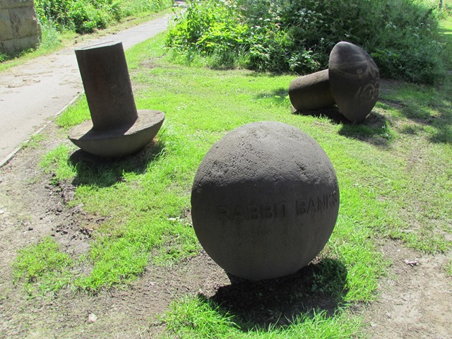
8 Co producing art
Along the walk route you might be able to spot many examples of public art. Sadly, we do not have time to dwell at them all. The piece here though is worth further attention. Called Riverside Rivets this is a ‘co-produced’ artwork, which means it was created in collaboration with local people.
Rivets are strong metal fasteners frequently found in bridges and heavy machinery. The Tyne Bridge, which is entirely made of steel, contains just short of 800,000 rivets. An 1890s map of Gateshead shows that near to this site was the Tyne Bolt and Rivet Works. This artwork is a reference to the local historical context.
For this piece, sculptor Andrew McKeown made the oversized rivets. Each rivet is inscribed with the name of a community by the riverside, including Teams, Staiths, Clasper and Rabbit Banks. Inside each rivet are plaster casts. Children from nearby St Aidan’s Primary School created them by selecting then making casts of their favourite objects. These sculptures therefore contain the memories of children from a particular point in Gateshead’s history.
Co-produced artworks like Riverside Rivets reflect broader trends in urban development. It is becoming less and less common for development organisations to try and ‘impose’ solutions on people. From hospitals to local authorities, artists and universities, the idea instead is to work with people - to find the solutions and activities that are most suitable or relevant for them or that they would most like to take part in.
The footpath forks at the King Edward VII Bridge. Take the left hand path uphill into the park (as opposed to continuing alongside the river). As you continue look out for more rivet sculptures. At the next fork in the path bear left. Turn left at the top of the hill to emerge at a road. Stop in the paved area with metal benches and sculptures.
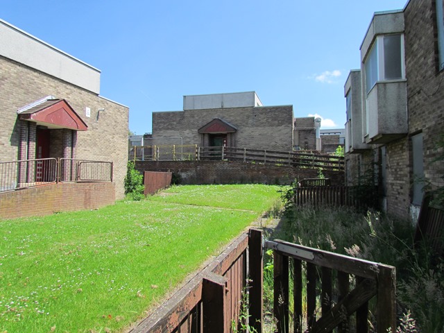
9 The lost village
We are now in a part of Gateshead called Teams, after the River Team that flows into the Tyne. At this stop, you will need to use a little imagination and refer to old photographs to appreciate what was once here. This area was once the site of Clasper Village, named after a Victorian rower from Tyneside called Harry Clasper.
Until the mid-1960s, Gateshead Council followed many others in building high-density flats. Although many have been demolished, you can still see some of these tower blocks today. Here in Teams, building tower blocks was not possible because of old mine workings underground. Instead, a series of low-rise housing blocks were constructed. They were referred to as villages and were essentially a modern form of back-to-back terracing.
In the late 1960s, there was a lot of pressure on local authorities to provide houses. Gateshead Council managed to build a thousand houses a year at this time. They were able to because the building industry had become more industrialised and it was possible to fabricate some component parts in factories and then assemble them on site.
The slum clearances of the 1930s were trying to combat poor health conditions and disease. By the 1960s, reformers were trying to combat a modern disease: the car and the increasing number of fatal accidents. Nearby you might be able to see a number of dual carriageways. To access the ‘villages’, pedestrians had to cross under them through subways. Though an admirable attempt to protect people, the subways indicated that cars still had precedence and isolated Clasper Village from the rest of Gateshead.
While many people enjoyed living here, anti-social behaviour increased. In addition, new concerns came to bear, such as refurbishing homes and making them more energy efficient. Gateshead Council decided that it was more cost-effective to demolish Clasper Village than to refurbish it.
When this walk was prepared in early 2014, the council was decanting the last remaining inhabitants before demolition. The Sure Start Centre – once a primary school – is one of the few remains of the social infrastructure built to accompany the estate.
Turn right and continue into Rose Street. When you come to the crossroads and traffic lights, turn right and walk downhill into Autumn Drive. Continue into the housing estate and stop when you reach a bench on the right near a children’s play area.
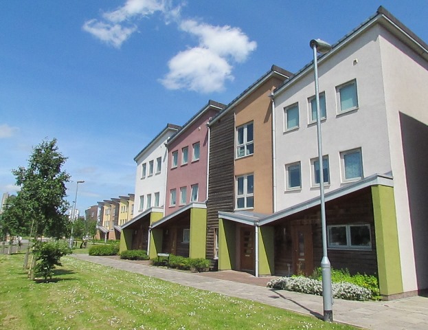
10 Sustainable communities
We have now arrived at a different kind of housing development, Staiths South Bank. While local authorities built places like Clasper Village, the introduction of the ‘Right to Buy’ scheme in the early-1980s meant that most housing since is built either by property developers or by semipublic social housing providers.
Many property developers work to very tight profit margins. As a result, the houses that they build tend to be quite conservative because these are tried and tested designs that the buying public seem to like.
In the late 1990s, the Labour government invested in identifying best practice in design. An ‘Urban Task Force’ recommended that urban regeneration must be excellent in design, promote social well-being, be environmentally responsible and economically viable. The Urban Task Force championed bringing people back into cities, which could help to reduce urban sprawl in the countryside and make it easier for people to give up their cars and perhaps cycle or walk to work.
The initiative provides some context to this estate. Staiths South Bank was built on land earmarked for development after the Gateshead Garden Festival - which we will find out more about later. The property developer Taylor Wimpey built it in collaboration with designers Wayne and Gerardine Hemingway.
The collaboration occurred after Wayne Hemingway publicly derided what he called the ‘The Wimpeyfication and Barratification of Britain’ where he believed that most housing developments built by big developers such as Wimpey and Barrat were very poor quality designs.
You will see that the estate confines cars to its edges and there are communal gardens, play areas and barbeques. It has won many design awards as a ‘sustainable community’. Would you like to live here? It is popular overall and Wimpey have continued with further phases of the design.
Continue downhill towards the River Tyne. Use the steps or the ramp to return to the riverside path. Stop facing the large timber structure.
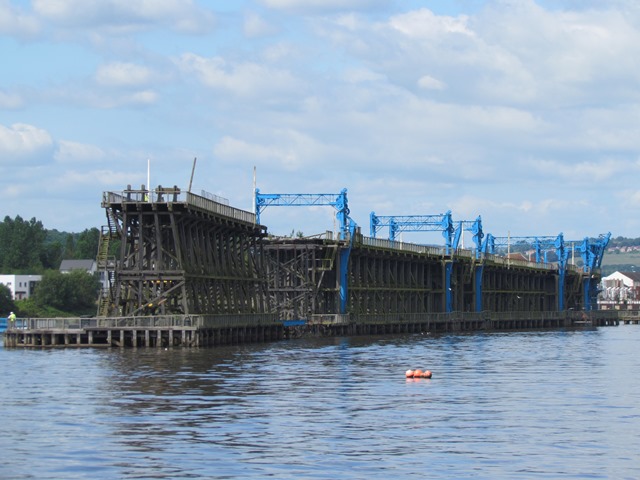
11 A question of heritage
This wooden structure is Dunston Staithes, an impressive piece of industrial infrastructure and one of the few remaining of its kind in the country. Dunston is a nearby village and ‘staith’ is a local dialect word that means something rather different to ‘jetty’ or ‘pier’.
At Keelmans Way, we discovered how waggon routes replaced keels for transporting coal to the Tyne. Waggons ran directly to the river from the Durham coalfields south of here. A set of tracks lined the top of the staithes, which allowed the waggons to discharge coal directly onto ships.
Much of Durham’s coal was used in London power stations and staithes sped up its transportation. By 1900 there were at least thirty staithes on both sides of the Tyne, from the mouth of the river in the east, to Blaydon in the west.
Over the latter half of the twentieth century, the coal industry declined due to the rise of Middle East then North Sea oil. The Dunston Staithes last carried coal in 1980. Though still standing, the structure is far from complete. There is a gaping hole in the middle and it has been subject to arson.
There is a question about what to do with such structures when their function has ceased. Many physical remnants of industry are cleared away. However, like arts and culture, heritage objects can help to reactivate areas. Objects like the Staithes can be assets: they can help to make an area distinctive, they can be a repository of memory, and they can be an educational tool about an area’s history.
Dunston Staithes belong to the Tyne and Wear Building Preservation Trust and are now Grade II listed. In 2013 the Trust received funding to make the structure safe. Working with artists and the heritage sector, the Trust runs a series of events around the Staithes. The hope is that these will catalyse interest and help find them a new viable function.
Turn left and walk to the end of the housing estate. Stop alongside the Staithes at the point where they touch land.
12 The seeds of regeneration
The Dunston Staithes briefly came back into use once. The structure was repaired using timber from an adjoining staith, which allowed it to open for public access. Bridges and walkways were built on the Staithes and ferries tied to it took passengers across the Tyne. This work took place for the Gateshead Garden Festival, which ran between May and October 1990.
Between 1984 and 1992, Britain held five National Garden Festivals. The first was in Liverpool. Gateshead ran the penultimate one on 200 acres of derelict riverside land. The site had been a gasworks, a coal depot and a coking plant. Three million people visited the Festival with the Dunston Staithes acting as the focal point.
The concept of Garden Festivals comes from Germany, where the biennial ‘Bundesgartenschau’ began in the early 1950s. Each festival provides an opportunity for reclaiming and landscaping former industrial sites for ecological purposes.
In the early 1980s Conservative minister Michael Heseltine introduced the policy in Britain to regenerate cities that had gone into post-industrial decline. The intention was that the Festivals would attract much-needed income through tourism.
The UK Garden Festivals were criticised because they did not manage to leave a substantial legacy. The sites also took a long time to regenerate. Here in Gateshead, for example, the original target was to decontaminate the Festival site land in five years. There were hopes of creating a marina facility by the Staithes. You can see that this has not happened though.
In reality, it took a long time to decontaminate and regenerate this area from its earlier industrial uses. Politicians and urban developers often look for quick wins but urban regeneration usually takes a long time with many factors to bring together.
Continue along the riverside path and go over the metal bridge. Stop by the large stones between the bridge and the road ahead (Staithes Road). Look across the river at the area of trees to the right of the bridge on the opposite bank.
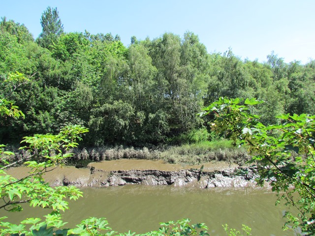
13 Natural development
This area of land is Saltmarsh Garden. Saltmarshes are found in relatively sheltered places subject to tides, such as bays, lagoons or estuaries. They are created when water carries and deposits sediment. Over time, more and more sediment accumulates into mudflats. These attract plants that trap yet more sediment. As the mudflats become more stable, they emerge as saltmarshes.
Saltmarsh Garden is interesting for the source of its formation. If you were at the previous stop when the tide was out, you might have noticed lots of mud. As ships no longer dock at Dunston Staithes, the water is no longer dredged so the area has silted up. The shape of the Staithes provided the shelter for the saltmarsh to form.
There are not many examples of saltmarsh in the Northeast so this site is of local ecological importance. Plant species here include wild celery, sea aster, saltmarsh grass and wild carrot.
During the Garden Festival some of the land was enhanced with further planting including the common reed. Unfortunately, this invasive plant is strangling the site’s natural plants.
Because the site is relatively undisturbed, a number of birds roost here during the winter months. They feed off the mudflats and use Dunston Staithes as a protective structure. Some of the birds are quite rare to this region including golden plovers and lapwings.
If the Staithes are brought back into use for people, ecological and economic concerns will have to be balanced. At present Saltmarsh Garden is not very well looked after but the site is an interesting example of how nature begins to take over when human involvement in the land ceases. It goes to show that places can regenerate naturally as well as by deliberate intervention.
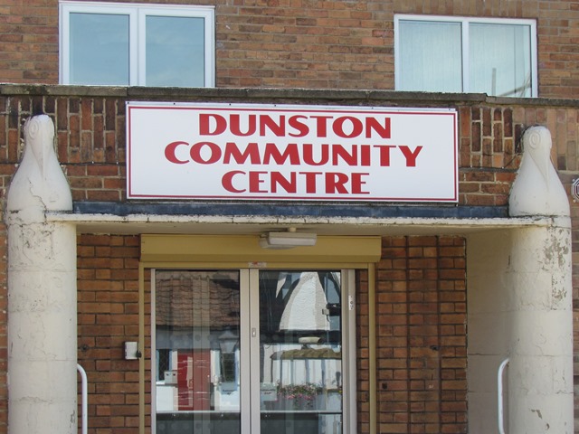
With the bridge behind you, continue along Staithes Road. At the end cross over Railway Street using the traffic island to the left. Turn right and stop outside the brick building, Dunston Community Centre.
14 The art of regeneration
Our last stop is Dunston Community Centre, which opened in the 1950s. Before then the building was a Seamen’s Mission that catered for workers attached to trade on the River Tyne. Formerly managed by Gateshead Council, the community centre is now run by local residents.
As the age of the Community Centre shows, there are places that seem to undergo continual regeneration. Many towns around the UK experience this besides Gateshead, including Woolwich in London, Salford near Manchester and Clydebank near Glasgow.
One reason perhaps is a long and protracted legacy of industrial decline. Another could be that regeneration itself is an evolving process. Certain places set out to make a statement through regeneration. In Gateshead, this meant embracing different strategies. Sometimes these reflected the conventions of the day, such as modernist planning in the 1960s. Sometimes they were simply about achieving the bottom line, creating more jobs and economic growth.
In Gateshead today the focus is on integrating the arts, green spaces and heritage into new developments and ensuring that everyone, not just a few afficionados, can enjoy them.
In exploring the riverside at Gateshead, we have seen many components that make the geography of urban regeneration such an interesting topic: iconic buildings, heritage structures, and the importance of connectivity between different sites. We have even seen spaces that get overlooked and forgotten about but regenerate naturally without human interference.
We began the walk by seeing heavily-financed prestige projects that aim to attract jobs and tourists. We end with a meeting space for local people. Both are a reminder that regeneration needs communities to make changes work. Regeneration has to go beyond simply providing housing and jobs – people need spaces to relax, play and meet each other. The only way regeneration works well is in remembering the needs of people.
We hope that you have enjoyed this walk around Gateshead and can appreciate the town a little more. The Community Centre is generally open from Monday to Friday, so go do feel free to pop in and see if there is a cup of tea available.
This is the end of the walk. Feel free to visit the Community Centre if it is open to enjoy some refreshments.
To return to Newcastle or Gateshead town centre there are frequent buses from a stop opposite the Community Centre. Alternatively, you may wish to return by following the riverside path. At the red and white Swing Bridge you can cross over the river into Newcastle or continue ahead to return to the BALTIC and Gateshead Quayside.
Your browser is out of date, and unsupported by this website. Please upgrade to the latest version to use this website.
The town of Gateshead is often overshadowed by its neighbour across the water, the city of Newcastle. But the two are distinct and unique places.
This walk tells the story of Gateshead’s evolving post-war identity, in particular through regeneration. Following a short stretch of Gateshead’s riverside uncovers the history of regeneration throughout Britain.
On this walk you'll trace Gateshead's journey from heavy industry to public art. Discover why an urban town hosted a Garden Festival. See symbols of Gateshead's proud heritage and plans for the future.
Follow the walk by clicking on the map pins or downloading the guides below
The BALTIC Centre for Contemporary Art, Gateshead Quays, NE8 3BA
Finish point:
Dunston Community Centre, Railway Street, NE11 9EB
Keep an eye out for:
Lapwings, otters and wildflowers at Dunston Staiths
Gateshead walk credits
Thanks to -
Angela Connelly for creating this walk, providing photos and the audio
Rory Walsh for editing the walk materials and providing photos
Caroline Millar for editing the audio
Tyne and Wear Archives and Museums, Victoria Sage, Britain From Above and Andy Williamson atPictures of Gatesheadfor kind permission to include images from their collections
Edward Wainwright at The Jetty-Project for kind permission to include his images of the Cone artwork
Brenda Clelland and Alan Tullett at Dunston Community Centre for helpful comments
Other images reproduced under Creative Commons Licences