Welcome to Kielder. Today, this area is an outdoor enthusiast’s paradise with so much to see and do. You could probably stay a week and still not do everything there is on offer! But its chequered history reveals a different side to this picturesque countryside.
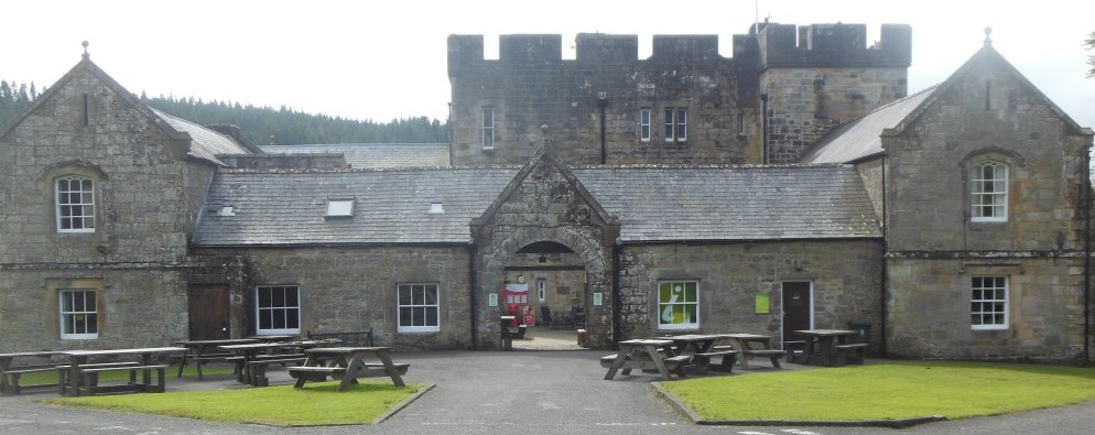
Nestled within this woodland scene, our trail starts here at Kielder Castle, less than two miles from the Scottish border. Most castles of Northern England hold prominent positions in the landscape - on hill tops or with rivers or sea on at least one side – to provide both vantage and defence from invading Scots.
Whilst geography plays its part here, Kielder Castle has a rather different purpose. It wasn’t built for defence, but instead as a hunting lodge for the Duke of Northumberland in 1775. The undulating uplands, their climate, and more importantly, the surrounding vegetation are all popular with roe deer.
The roe deer use the numerous coniferous trees which extend as far as the eye can see, for several purposes. Firstly, the male roe deer ‘trash’ the younger trees to remove the velvet from their antlers (a process known as fraying). Deer also strip the bark from trees using their teeth, leaving ‘wounds’ which may not heal and eventually cause the tree to die.
Deer are also known to rub up against trees, a process known as ‘browsing’, which can cause trees to grow in loops or even tangle as opposed to growing tall and straight. Though much of the forest looks like row upon row of Christmas trees ready to be felled ahead of the festive season, look closely enough and you may see the signs of dying or curiously looping trees.
With Roe deer flourished here, the Duke of Northumberland seized the opportunity and set up this handsome lodge. With vast areas of woodland at his disposal, he and his hunting friends could wait for the deer to come to them in the comfort of their castle, rather than having to travel here from the nearest towns or villages tens of miles away.
So although it may look like an unassuming castle in a maze of trees, the relationship between the two has more significance than you might first have thought.
Directions
Continue down the hill using the stepped path for approximately 100 metres passing the Anglers Arms and over the River North Tyne.
Once you reach the road, cross it and turn left walking a further 20 metres. Here, prior to crossing Kielder Burn, turn right down a narrow path called ‘Lakeside Way’.
Follow this path for approximately 550 metres until you reach the road with a vehicular bridge adjacent to the left. Stop here.
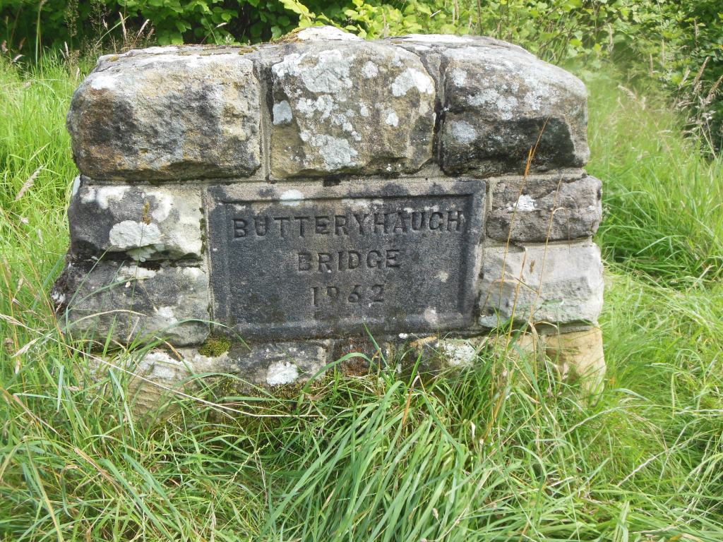
2 Butteryhaugh Bridge
Aside from castles, Kielder’s story is also shaped by its rivers. While the Duke would have had many to cross, you have the luxury of this bridge.
To your left is Butteryhaugh Bridge built in 1962 to link the villages of Kielder and Butteryhaugh. Crossing Kielder Burn, it really is a lifeline between the two villages - there are no other bridges traversing the water for a further seven miles downstream!
But aside from bridges, Kielder’s mark on the map may have been forever marred by the names of its waterways. Kielder Burn isn’t a well-known watercourse away from the local area. However one of the rivers that feeds into it is the North Tyne – a name which probably sounds a lot more familiar.
What is strange is that when the North Tyne meets Kielder Burn, the combined watercourse is known as ‘Kielder Burn’, suggesting Kielder is the more prominent of the two. But just a little downstream, everything changes.
The burn continues and flows into Bakethin and Kielder reservoirs. In all, over a dozen watercourses flow into the two reservoirs but only one flows out. And what is that one river called? The North Tyne!
So, although when the two watercourses first join forces it is Kielder that wins the name game, it ceases to exist just over 1 kilometre downstream. Instead, the North Tyne continues for a further 30 kilometres eventually meeting the South Tyne to form the most famous river in the north east of England - the River Tyne.
Had this been realised at the time of naming the rivers, the River Tyne as it is now known might well have been the ‘River Kielder’; Newcastle-upon-Tyne might well have been ‘Newcastle-upon-Kielder’ and we may have all been singing about the ‘Fog on the Kielder being mine all mine’!
Directions
Do not cross the bridge but continue straight on in the direction you have been travelling. After approximately 200 metres you will reach ‘Kielder Viaduct Car Park’.
Walk past the information boards following the footpath up a short incline as the path zig zags.
At the top of the incline take the path to the left sign-posted ‘Kielder Viaduct’ and continue for a further 150 metres. Stop here.
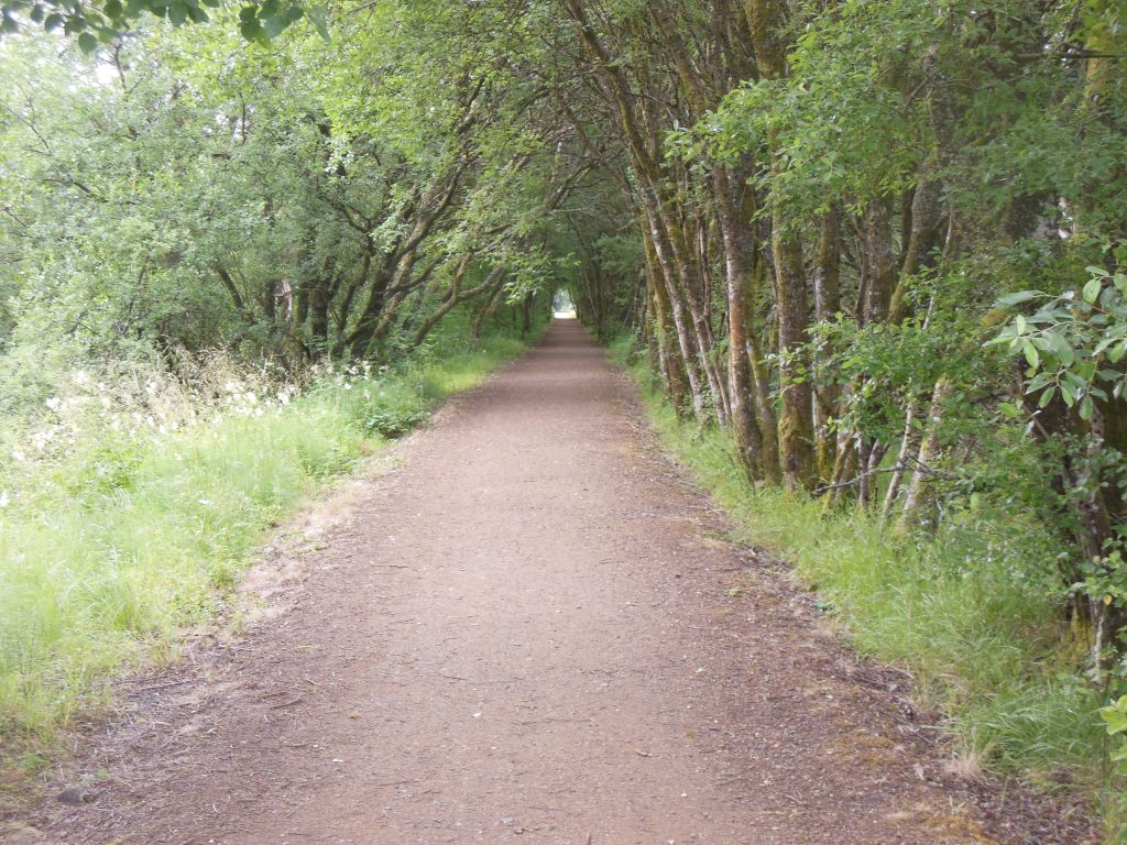
3 Tunnel of Trees
For the last minute or so you have probably been wondering where the weather has gone? It is no longer sunny or raining yet you are still outside. You are currently under a ‘tunnel of trees’.
The path is so straight because it follows the line of a former railway. Since the railway has gone the trees on either side of the path have flourished and grown into the space above, creating this dramatic green tunnel of foliage.
And the leaves don’t stop here. Kielder Forest is the largest manmade woodland in Britain. It was created in the 1920s from what was previously open moorland, managed for grouse shooting and sheep grazing.
This all changed following timber shortages during the First World War. At this time the Forestry Commission was set up. It purchased swathes of land across the country with the brief of establishing a strategic reserve of timber for the nation.
Kielder is therefore now dominated by conifers, which were quick to grow and yielded plentiful timber. Sitka spruce covers 75% of the planted area; this species thrives in the damp conditions afforded by northern Britain. Other species include Norway spruce and lodge pole pine, which cover 9% of the area each. The remainder is made up of Scots pine, larch, Douglas-fir, and broadleaves including birch rowan, cherry, oak, beech, and willow.
The single objective of timber production held sway until the 1960s. Since then management principles have shifted, reflecting rising awareness of environmental concerns and the need to provide recreational facilities, whilst still seeking to maintain a sustainable supply of timber.
Kielder remains state-owned but it has developed into a multi-purpose forest. Bird-watching, bike-riding, walking and star-gazing are amongst just some of the many recreational activities taking place around you today.
Directions
Continue walking forward for a further 150 metres. Stop here.
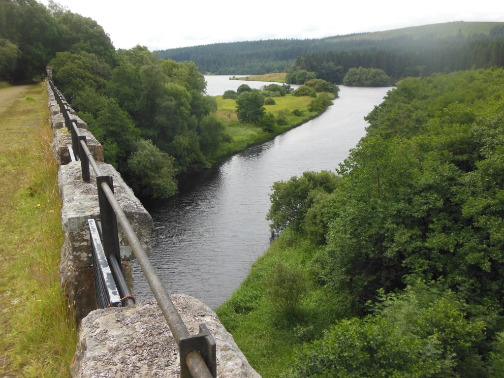
4 Kielder Viaduct
As if by magic, you are no longer enclosed by trees but are now high above their tops, gazing down onto the evergreen canopy below.
Standing on top of Kielder Viaduct you have great views across Bakethin Reservoir to the south, and to the top of the 571-metre high Deadwater Fell (the one with the satellite dish) to the north. Whilst nature frames most of your view, the spot where you are standing is very much man-made.
This gives us clues to the landscape’s competitive industrial past.
This viaduct forms part of the former Border Counties Railway, a line which connected Hexham in Northumberland, with Riccarton (now in the Borders region of Scotland). Its promoter had hopes of exploiting mineral resources in the area, and it was taken up by the North British Railway (NBR), which hoped to develop it as the only main line between Scotland and England.
But the race was on!
At the same time, routes to the west between Glasgow and Carlisle and to the east between Edinburgh and Newcastle were also being proposed. As Kielder’s route avoided the challenging terrain of both the Southern Uplands and Cheviot Hills, in the early 1840’s this line looked the likeliest contender. At the time locomotives’ ability to climb steep and lengthy gradients was pretty limited.
So what went wrong?
The debate about an Anglo-Scottish route continued over some years. The capabilities of steam locomotives improved, and the increasing availability of money moved the issue away from a single route determined by geographical considerations, to simple economics.
And so, by 1846 the NBR opened a line from Edinburgh to Berwick-upon-Tweed, running close to the coast avoiding high ground. At the same time the Caledonian Railway constructed a line from Glasgow and Edinburgh to Carlisle, crossing the previously un-traversable Southern Uplands.
Whilst the Border Counties Railway through Kielder did eventually open, the anticipated commercial success was disappointing and the sparse population produced very little local traffic. The line was a huge failure and closed to passengers in 1956 and completely in 1963.
Today, the viaduct and the tree-lined path of the previous stop are all that remain of Kielder’s locomotive ambitions. But what do you think this area would look like now had the railway succeeded? Would the forests and lakes still seem so serene? Maybe what it lacked in connectivity, it has since made up for in seclusion.
Directions
Continue walking forward for a further 250 metres. Do not follow the wider more obvious path which turns to the left but instead take the narrower path ahead.
This path becomes boggy in places and can be narrow with overhanging shrubs.
Follow this path for a further 750 metres until you cannot follow it anymore as it disappears beneath the reservoir ahead.
A solitary railway sleeper marks the spot, next to a life buoy. Stop here.
5 Underwater Railway
Since you turned right into the ‘tunnel of trees’ you have been following the route of the former railway. But follow it any further and you might need a wetsuit!
It is here the railway disappears beneath the waves. Kielder Dam was built in 1979, and so created the peaceful expanse of Kielder reservoir you can see before you. Its creation marked a definitive end to train line dreams, but it too was an engineering project destined for failure.
The scheme was planned in the late 1960s to satisfy an expected rise in demand for water in a booming UK industrial economy. But the decline of traditional heavy industry, together with more water-efficient industrial processes and better control of water supply leakage, served to undermine the investment.
Finally approved by Parliament in 1975, work to build the reservoir and dam began. The design meant the loss of numerous farms, a school and of course the former Border Counties Railway line. Almost 10 years later, work was completed, although the valley took a further two years to fill completely with water! Not the success story Kielder was looking for.
Looking around today, the man-made lake seems far from being a blot on the landscape. Instead it is a nationally renowned centre for outdoor activities, and haven for wildlife and those who enjoy watching it.
But it also plays an unexpectedly fundamental role in the nation’s water supply.
It underpins the £167m Kielder Transfer Scheme, where water can be transferred to the rivers Wear and Tees to meet shortfalls in those areas. In recent years, Kielder’s water has become increasingly important, with underground springs ensuring that it always remains at high levels, regardless of the climate conditions. This means that while the south of England is often forced to implement drought strategies and hosepipe bans, north east England enjoys plentiful water supplies!
Not quite the failure after all.
Directions
Walk along the water’s edge to your left picking up the main path you earlier ignored.
Turn right onto this main path and follow it passing a ‘Sharp Bend’ sign just prior to crossing a bridge after approximately 500 metres.
For the next 200 metres the path loops around to the left with a row of trees separating you from the water’s edge.
Just as the path straightens, turn off this path along a smaller path to your right along the water’s edge aiming for a raised grass area set upon concrete.
Walk through the trees, over a solid steel manhole cover across to this raised grass area until you see a weir directly in front of you with a totem pole-like column across the other side of the small gap in the water. Stop here.
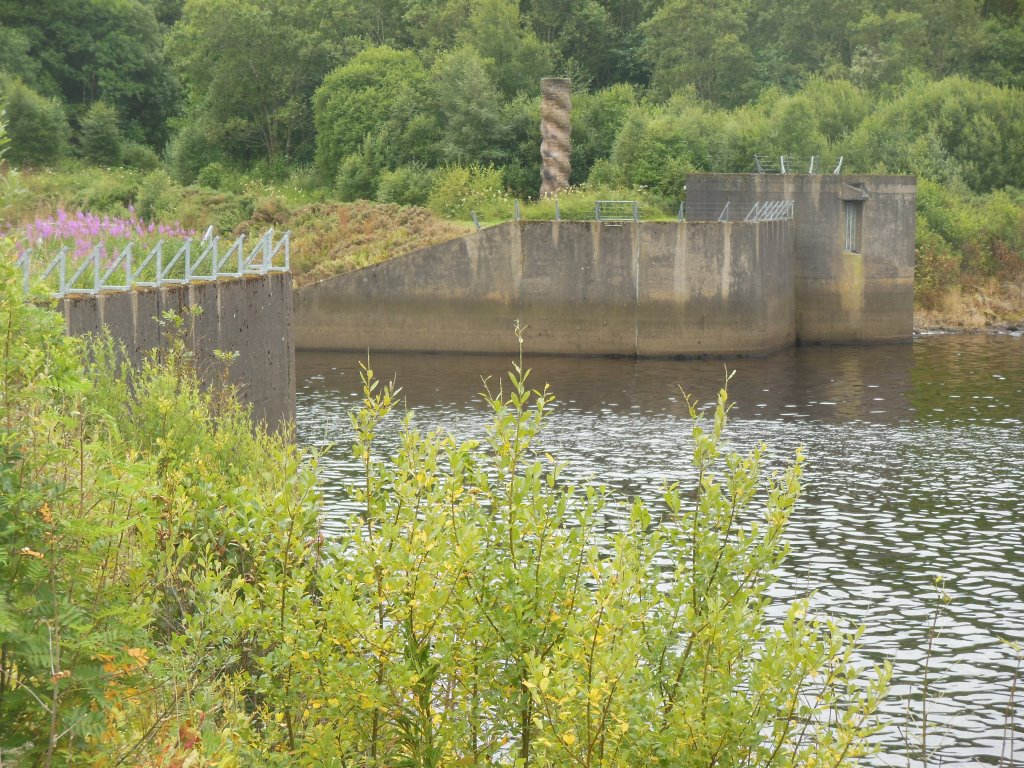
6 Bakethin Weir and Kielder Column
You are now at the final stop on our trail and hopefully you can see Bakethin Weir separating the two reservoirs (Bakethin and Kielder) along with a totem pole. Known as ‘Kielder Column’, the pole is just visible through the trees on the opposite bank.
Why mark a weir? Well, it has an important part to play in the way the view looks today.
Without this weir, you might instead be looking at unsightly mud flats. The 165-metre long, 12.5-metre high wall of sand, gravel and rock prevent mudflats from forming at times of low water. Keeping the two bodies of water separate they are able to be well regulated and levels maintained.
In Bakethin Reservoir, this has enabled the creation of a nature reserve. This Northumberland Wildlife Trust conservation area includes plants, birds and other wildlife including otters, one of the ‘Kielder Super Six’ species of mammals, bird and fish.
The rare combination of open water, wetland, woodland and grassland provide a haven for a cacophony of creatures throughout the year.
Wildfowl are best viewed during the winter months. Visitors include the goldeneye, and early and late in the year there are sightings of whooper swans en route to or from the Arctic. In spring, the reserve can give views of osprey, merlin and goshawk during their courtship.
If you’re lucky, you may also spot an otter hunting along the edges of the lake. The shallow water margins also offer valuable spawning grounds for the common frog and palmate newt and there is a healthy fish population. Adder and common lizard are also regularly recorded.
So although never meant for this purpose, Kielder is also now being carefully managed to carve out its own niche in the landscape. Exmoor ponies and hardy sheep graze the site, helping to maintain the diversity of the wet grasslands and flushes. New native woodlands are being encouraged to spring into life.
Kielder’s climate, topography and the needs of industry have transformed the land time and time again. But at every step of this trail we have seen how Kielder’s biggest successes have often been built upon the remnants of its failures - failure of the Kielder Burn to out-do its rival Tyne in the river-naming wars; failure of its railway to compete with advancing technologies; failure of the reservoir to serve its original purpose.
But all these failures haven’t stopped it becoming an attraction in its own right, with forests, waters and skies to rival all others across Britain.
As the saying goes, if at first you don’t succeed....
Directions
You can either return to the start point by retracing your steps or alternatively return to the main path you left some moments ago and follow this back the way you came but remain on this path as opposed to taking the smaller paths.
Where the path splits, ignore the sign for ‘Kielder Village via Kielder Viaduct’ but instead follows the signs for ‘Kielder Village / Kielder Castle’ and ‘Butteryhaugh Bridge’ and continue through the trees with views through the trees across to Kielder Viaduct you crossed earlier in the walk.
After passing a small sewage works on your left, continue a further 75 metres where you can either cross Butteryhaugh Bridge to follow Lakeside Way back to the start or take a slightly longer route and follow ‘South Waterside’ and ‘South End’ roads through Butteryhaugh, crossing Kielder Burn, with Kielder Castle just up the hill on your right.
Your browser is out of date, and unsupported by this website. Please upgrade to the latest version to use this website.
There are few places in Britain where you can leave your car and be in the middle of the wilderness just ten minutes later.
But in Kielder, with its lack of crowds, fresh countryside air, secluded waterside bays and huge tree-lined paths you really get the sense you are the last (or first!) person on Earth. Your very own ‘Garden of Eden’.
Whilst this would suggest Kielder is a raving success, this has not always been the case.
Weave your way through Kielder’s lesser-known mishaps to uncover the ‘natural’ beauty it offers today.
Follow the trail by clicking on the map pins or downloading the guide below
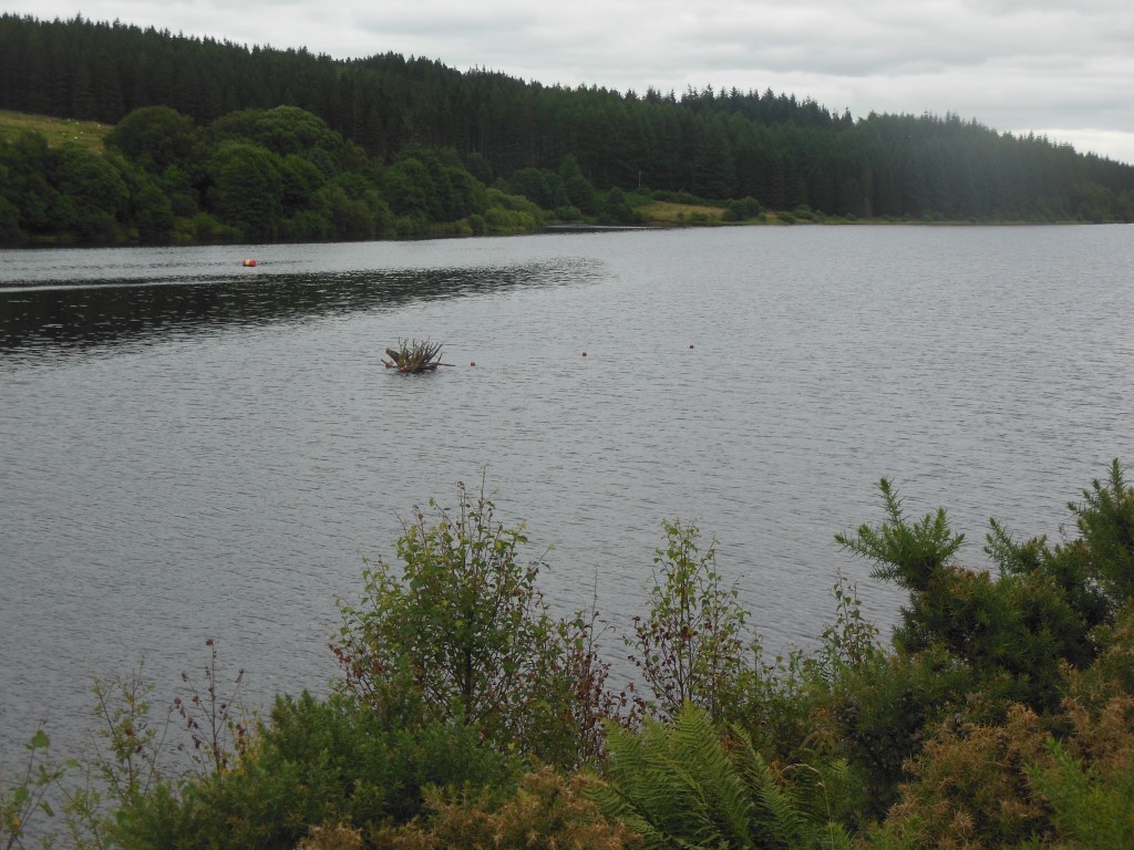
The north shore of Bakethin Reservoir, near Kielder, Northumbria
Start point:
Kielder Castle, NE48 1EP
Finish point:
Just off the Lakeside Path adjacent to Bakethin Weir, NE48 1HL
Grid reference:
NY 63163 93528
Directions to start:
Park in the (fee charging) car park at NE48 1EP and walk down the hill a short way to the castle
Keep an eye out for :
The ‘Kielder Super Six’ – Pipistrelle Bats, Roe Deer, Ospreys, Salmon, Otters and everyone’s favourite, the Red Squirrel – with over 50% of England’s population living here.
Kielder trail credits
Thank you to:
Chris Speight FRGS, CGeog, RGS-IBG Trustee / Councillor for devising, writing and photographing this trail
Jo Kemp for edits and suggestions
Wikimedia for additional images, reproduced under the Creative Commons Lisence.
Kielder has the biggest man-made lake in Northern Europe, the biggest working forest in England and one of the largest International Dark Sky Parks in the world!

")