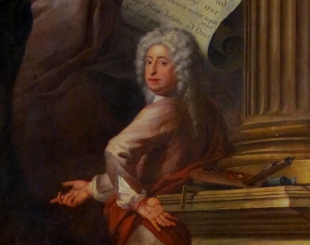
Greenwich in south east London is one of the most famous maritime sites in the world. Its UNESCO World Heritage landmarks include the Royal Observatory, Old Royal Naval College, the National Maritime Museum and the Cutty Sark.
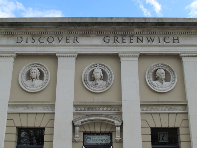
Every year these attract thousands of international visitors. So it is fitting to begin by the Discover Greenwich Visitor Centre. This Grade II listed building was once part of the Naval College. Inside is an excellent museum about Greenwich’s maritime history, while the outside features a row of sculptures of famous maritime figures. See how many names you can recognise.
This walk explores how Greenwich became such an important maritime site. We will visit world-famous landmarks and also see lesser-known places. The walk was created in 2012 by local historian Rich Sylvester. It was originally part of a series that explored how our towns and cities have been shaped for many centuries by some of the 206 participating nations in the 2012 Olympic and Paralympic Games.
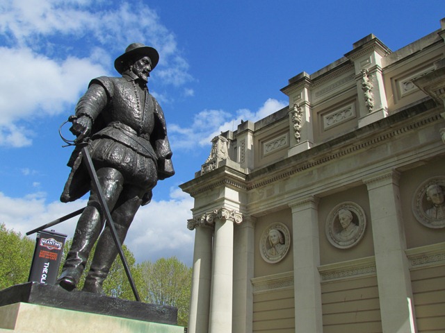
Remain outside the Discover Greenwich building and stop beside the statue of Sir Walter Raleigh.
2 Raleigh’s cycle
We start with one of Britain’s greatest maritime explorers, Sir Walter Raleigh. Also a soldier, poet and writer of a “History of the World”, his life was a colourful travelogue.
His career began in Ireland then in 1584 he established the first colony of English settlers in Virginia in North America. While there he took up smoking tobacco and on his return to England he made smoking a fashionable pastime at the Elizabethan court.
Raleigh then heard accounts about El Dorado, a mythical ‘City of Gold’. In search of it, he explored Guyana and the Orinoco River in Venezuela. During the trip Raleigh’s men attacked San Tomé, which was a Spanish occupied territory. The Spanish were outraged and demanded Raleigh’s execution.
Raleigh had fallen out with Elizabeth’s successor, King James I. So in 1618 the king had Raleigh executed on charges of treason.
Near to Raleigh’s statue is a Turkish cannon taken by the Royal Navy from Kinali Island near Istanbul in 1807. To the right is an obelisk to the soldiers who died in the nineteenth century New Zealand Wars, where the Maori people resisted their land being taken by European settlers.
These memorials and Raleigh's statue show how Greenwich is connected to imperial history worldwide. Throughout the walk we will hear how Maritime Greenwich developed.
With your back to the statue, take the path in front of the cannon and go through the iron gates. Turn left and go to the Cutty Sark Visitor Centre at the back of the ship.
3 The price of a cuppa
This magnificent sailing ship is one of Greenwich’s most popular attractions - the Cutty Sark. An estimated 15 million people worldwide have come to take a tour around the last surviving ‘tea clipper’.
Tea clippers were ships built to carry cargoes of tea from China. With huge demand for tea in 18th and 19th century Britain, ships raced to be the first to dock in London. A journey from China took around 70 days.
The Cutty Sark was built in Scotland in 1869. Although she began life as a tea clipper, faster steam ships eventually took her trade. So the Cutty Sark carried other cargoes. These included coal, spirits and wool. In 1895 she was sold to the Portuguese. She returned to Britain in the 1920s and has been in Greenwich since 1954.
When she was built the Cutty Sark cost £16,150. By contrast her recent restoration cost £50 million. The process took nearly seven years and, despite the delays caused by a major fire, she reopened in April 2012.
Donors for her restoration included internatioanl shipping firms and even a Hollywood film producer, Jerry Bruckheimer. As you can see, you have to pay to go onto the ship but a visit is well worth it to explore this fascinating piece of maritime history.
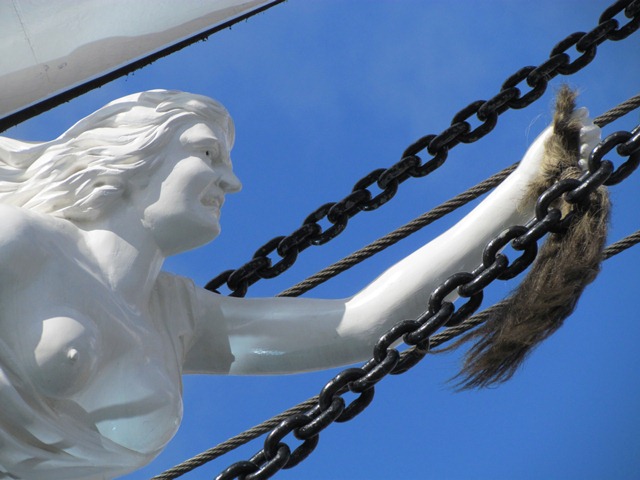
Make your way to the front of the ship and stop when you have a good view of the figurehead on the bow.
4 A witch’s tale
Today the Cutty Sark name is recognised worldwide, even giving its name to a blend of whisky. But where does the name come from? From here we can see the Cutty Sark’s figurehead - a witch holding a horse’s tail. She features in a poem by Robert Burns called ‘Tam o’ Shanter’. Cutty Sark is a Scottish term for the witch’s dress.
Look up and we can appreciate the sheer size of the Cutty Sark’s masts and sails. A fully rigged clipper carried 32,000 square feet of sail. Every inch was vital as journeys were carried out nonstop in a constant battle against wind and tide. Sailing a clipper took enormous skill and effort. The fastest clippers won a top price for their cargo but also a bonus of £500 for their crew.
The Cutty Sark’s crew were mostly Scottish and English, but were also recruited from ports worldwide. One example the ship’s cook, Tony Robson. Originally from China, he had been found abandoned as a baby on a mid-ocean raft. He learned English from his shipmates and spoke with a broad Scots accent.
As well as being an historic attraction, the Cutty Sark is a memorial to these men and a reminder of Greenwich’s role in maritime history.
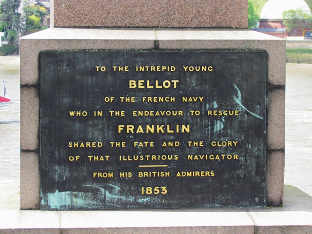
Walk between the restaurants and the grounds of Discover Greenwich building. Follow the riverside path up to the obelisk marked Bellot.
5 The royal riverside
This large granite memorial is to Jean Bellot, a French naval officer who died in 1851. Bellot was on an expedition in search of Sir John Franklin and the 128 men who had disappeared in the Canadian Arctic while attempting to find the ‘North West Passage’.
Since Tudor times British explorers had sought this channel. The route would pass through the Arctic ice around North America and lead to the fabled ‘Spice Islands’ near China and Japan.
The Bellot memorial gives us a chance to explore the role of two important factors in Greenwich’s growth - the river and royalty.
Greenwich developed from a small fishing village known as Grenewic. Its riverside location made it a natural harbour. Ships of various sizes from all around the world have visited Greenwich for over a thousand years.
The Romans landed at Greenwich and built a villa in the park. In the ninth century the Vikings anchored their longships in the river for three years. The Normans settled here after 1066 and a succession of royal palaces was built from 1300.
From the Tudor era Greenwich became the first port of call for ambassadors arriving from across Europe. They travelled up the River Thames in fleets of rowing barges carrying horses, troops and courtiers to be received in state by the king.
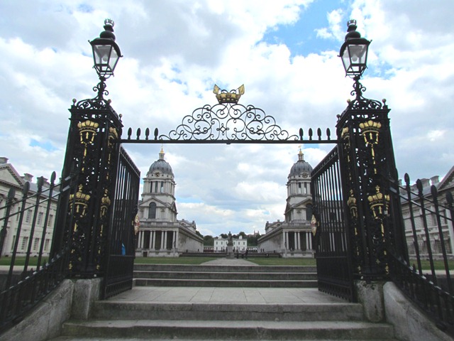
Continue along the riverside path a short way until you reach an ornate pair of iron gates. Stop in front of them.
6 School for sailors
We have now arrived at the heart of historic Maritime Greenwich. Soldiers and sailors, diplomats and politicians, scholars and tourists from around the world have all stepped off ships here.
Through the Water Gate we can see the twin domes of the Old Royal Naval College. Between them is the Queen’s House. This riverside view is one of the most spectacular in London. In 1752 it was captured by Italian painter Canaletto.
After seeing the plight of sailors wounded at the Battle of La Hogue in France, Queen Mary II suggested a naval hospital should be built on the site of the former royal palace. Her husband William III agreed and her brother Prince George of Denmark chaired the building committee. Building work began in 1696 and lasted over 50 years. The architect was Sir Christopher Wren who also worked on St Paul’s Cathedral.
In 1869 the hospital closed and the buildings became the Royal Naval College. It provided scientific training and practical seamanship courses. Among the captains, engineers and marines who studied here were a few students from Russia, Japan, Germany and China. One was Yen Fu, who attended in 1877 and became an important figure in the Westernisation of China.
During the Second World War the College trained students from many Allied countries. Today the College’s latest tenants are Greenwich University and Trinity College of Music, both attracting students from worldwide.
Continue along the riverside path. Pass the Trafalgar Tavern and take the first path on the left, which is Crane Street. Continue through Highbridge. Keep alert for cyclists, especially where the path narrows. Pass the white Trinity Hospital building and Greenwich Power Station. Continue up to the Cutty Sark Tavern and stop by the large anchor outside.
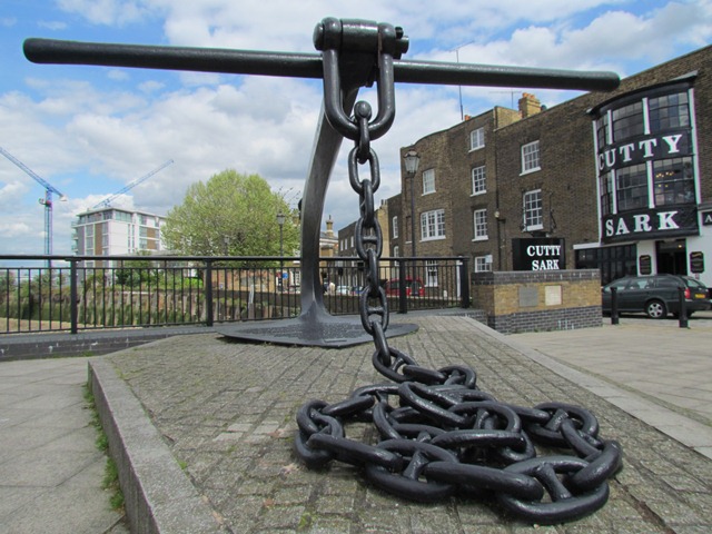
7 Any old iron?
We are now in East Greenwich. This area has a proud industrial past quite distinct from the buildings of the World Heritage site. Here trade ships and maritime industries lined the riverbanks. This anchor sculpture by Wendy Taylor features an inscription that offers a succinct history of this spot.
Over a thousand years ago the land was granted to monks from St Peters Abbey in Ghent, Belgium. They occupied a priory near to the power station. The anchor was also the symbol of Quaker ‘ironmasters’ Ambrose Crowley III and his son John. In the eighteenth century they lived in an impressive mansion on the site of the power station.
The Crowleys sold anchors and a wide range of other ironware to the Navy and other customers. They also made chains and shackles for the Atlantic slave trade plus mattocks, axes and hoes specifically for the sugar, cotton and tobacco plantations of Barbados and the American colonies.
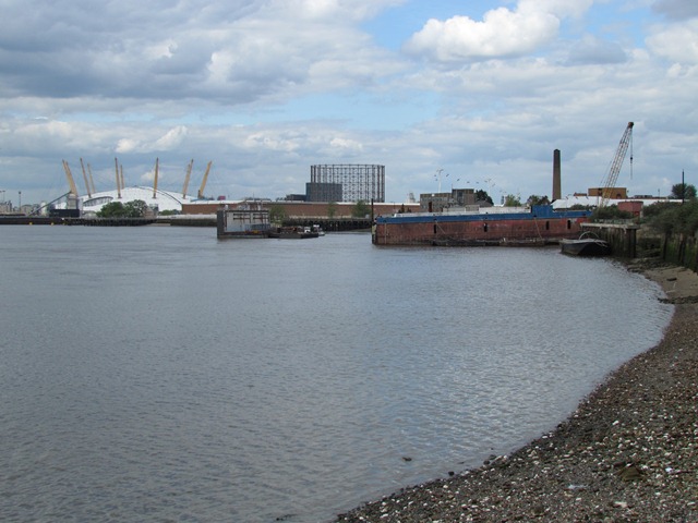
From the anchor we can also see modern developments in Greenwich Peninsula. Further along the riverbank is the O2 Arena, which opened as the Millennium Dome. It was built in 1999 on the derelict site of a former gas works and is now a music and sports venue.
Beside the Arena we can see the Emirates Air Line. This cable car over the Thames links Greenwich with the Royal Docks. The project is funded by the Emirates airline of Dubai.
Pass the Cutty Sark Tavern, keeping alert for cyclists. As the road turns to the right, stop by the riverside wall. Look across the river.
8 Wiring the world
Further up the riverbank towards the O2 was the location of many local industries. Enderby’s Wharf is named after Samuel Enderby who ran a fleet of ships which carried tea from China to the United States and returned with barrels of whale oil.
After the American War of Independence, Enderby switched his business to carrying convicts and supplies to Australia. Enderby’s ships also hunted whales and explored uncharted islands around Australia and New Zealand.
In the 1830s his sons Charles and George were active in the Royal Geographical Society. New Zealand’s Enderby Island was named after them.
From 1850 various companies developed underwater telegraph cables on this site. Thousands of miles of cable were manufactured here, loaded onto ships and then uncoiled across the sea beds. It was waterproofed with ‘gutta percha’ gum from Malaysia.
Cables were laid from Ireland to Canada, Canada to France, Egypt via the Yemen to Bombay, Portugal to Brazil, Australia to New Zealand, South Africa to St Vincent, the United States to Cuba, the Netherlands to Denmark, and Britain to Iceland. East Greenwich wired up the world.
Other local industries filled the riverbank. Where the O2 stands today, Blakely and Co made cannons. Guano (bird droppings) from Chile and Peru was turned into fertiliser. Coconut, palm oil and linseeds from the West Indies were made into soap and oil. In the age before refrigeration, ice from Norway was processed here. Norwegian stone is still unshipped at Victoria Deep Wharf today.
Retrace your steps back along the riverside path. Look out for a strange creature on the wall of the Power Station! Stop when you reach the Trafalgar Tavern.
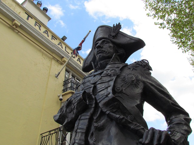
9 Naval hero
This tavern brings us to a man who ensured Greenwich’s international position. Admiral Horatio Nelson had a long and distinguished Navy career. His victories brought many of the world’s seas under British control, which opened up exploration and trade routes for the British Empire.
Nelson’s early career took him to within ten degrees of the North Pole then on to India and back. He was then involved in the Caribbean during the American War of Independence before cruising to the Central American coast, British Honduras and Nicaragua.
Nelson was in charge of accompanying convoys of ships from Russia, Ireland, Canada and America. He then spent more time in the West Indies including Jamaica, the Turks Islands, Antigua and Nevis. After seven years in the Mediterranean he went to the Baltic and the Battle of Copenhagen.
Then in 1805 came the Battle of Trafalgar. This sea battle took place near Gibraltar in southern Spain. ‘Trafalgar’ is the Anglicised name of the Cap Taraf al Gharb or “Cape of the West”. During the battle Nelson was killed while leading the victorious British fleet against the combined navies of France and Spain.
After his death Nelson’s body was transported to Greenwich. He lay in the Painted Hall of Greenwich Hospital for three days before his coffin was escorted by 10,000 sailors and soldiers to St Paul’s Cathedral.
The Trafalgar Tavern was built in 1837 and became famous in the nineteenth century as a meeting place for politicians, who held ‘whitebait dinners’ here. It later became a seamen’s hostel before reopening as a pub in 1965.
With your back to Nelson’s statue, walk into Park Row. Go through the large gates on the right and continue into the Old Naval College grounds. Take your time to enjoy the views of the grand buildings. When you reach the steps on the left, use them or the ramp at College Road nearby to enter the Painted Hall.
10 Maritime murals
The Painted Hall is one of the outstanding features of the Old Royal Naval College. It has been described as the finest dining hall in Europe. As we can see the Painted Hall is adorned with spectacular murals.
They were created by Sir James Thornhill, who painted the interiors of many famous British buildings, including inside the dome of St Paul’s Cathedral. For his work on the Painted Hall, Thornhill was paid by the square yard (£3 for the ceiling and £1 for the walls). His instructions were to include as many references as possible to Britain’s maritime power.
The murals include figures from Greek mythology, a captured Spanish galleon and the plans for the Naval College towers. The royals of the time also feature. The West Wall depicts George I and his family. George was Britain’s first king from the House of Hanover in Germany. The mural on the wall to our left shows him arriving at Greenwich to claim the throne in 1714.
The Painted Hall was completed as part of the naval hospital. It was intended to be the sailors’ dining room but was deemed too grand. Instead the Hall became one of London’s first tourist attractions. Ambassadors from many European countries dined here to seek favour or create alliances with Britain’s monarchs.
The Painted Hall still has a diplomatic function today and has hosted state leaders and royalty from around the world. In front of the West Wall, look for a stone in the floor marks where Admiral Nelson’s coffin was placed after his death.
When you are ready, leave the Painted Hall by the way you came in. Turn left and walk around the back of the building to Romney Road. Use the traffic lights to cross over then turn left. Enter the grounds in front of the National Maritime Museum. Stop outside the main entrance.
11 The world at sea
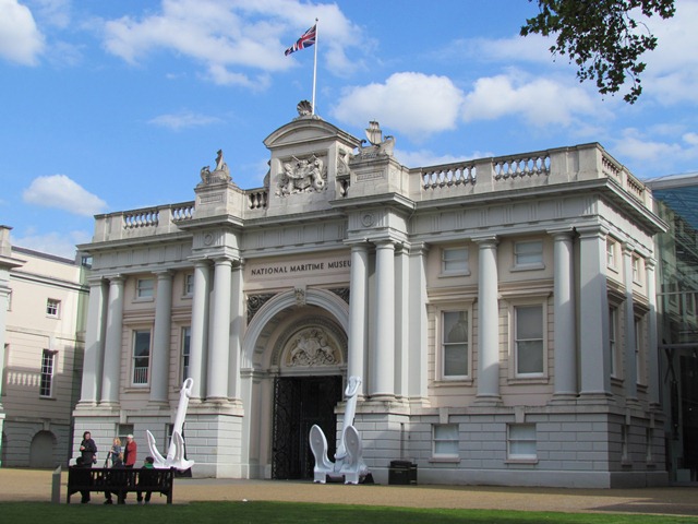
The Painted Hall we saw at the previous stop evolved into a naval museum and art gallery. When the collection got too large a new home was needed. The National Maritime Museum was founded in 1937 and celebrates ‘500 years of Britain’s encounter with the world at sea’.
It is the world’s largest maritime museum and houses a vast collection of exhibits. The 2.5 million items include maps, books, paintings, model ships and seafaring equipment.
One of the oldest exhibits in the Museum is a fragment of the Gibeon meteorite, which fell to Earth 25 million years ago. Other exhibits include an Azimuth compass made by Ralph Walker, a sailor in Jamaica; a bugle used by naval forces in the Indian Mutiny; and Admiral Nelson’s breakfast crockery.
The museum is free to enter so you may like to explore it at the end of the walk. Before we go, look up at the building’s façade and we can see the highest coat of arms by the flagpole feature a merman and ‘merlion’! There is also a pair of Viking ships on the roof, a reminder of the earliest maritime settlers in Greenwich.
With your back to the museum, turn right and continue up the path until you are level with the white building on your right. Take the path up to it and stop outside when you have a good view.
12 A regal residence
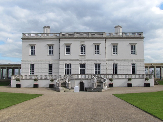
The Queen’s House is the oldest building in the Maritime Greenwich site. Parts of it date back to the later years of the royal palace. It was built from 1616 for Queen Anne of Denmark, wife of King James I.
Anne died before it was finished and in about 1635 it was altered for Henrietta Maria of France, the wife of Charles I. Dutch and Italian painters were commissioned to decorate the interior.
By the 1800s the building housed the Royal Hospital School for children of naval families. The long colonnades on either side were added to link the building to the children’s dormitories. Many former pupils had their ashes scattered on the lawn.
Today the Queen’s House is used to exhibit the Maritime Museum’s fine art collection. Besides historic royal importance the Queen’s House is a landmark in British architecture. When it was completed it was the first building in Britain made entirely in Classical design.
Classical architecture refers to the building styles of ancient Greece and Rome. The architect of the Queen’s House was Inigo Jones who designed it after returning from a Grand Tour of Roman and Renaissance sites in Italy.
If we turn around for a moment we can see why the Royal Hospital was built in two sections – to protect the direct view from the Queen’s House to the river.
Keep the Queen’s House on your left and walk along the colonnade to the right of it. At the end of the colonnade turn left, then make your way to the back of the Maritime Museum. Stop by the ship in a bottle at the entrance.
13 A generous Ofer
We are now beside one of the latest developments at Maritime Greenwich. This is the entrance to the new Sammy Ofer Wing of the National Maritime Museum.
Sammy Ofer was a shipping magnate who became the richest man in Israel. Born in Romania, in 1924 he migrated to Palestine. During the Second World War he served in both the British and Israeli navies. He bought his first small cargo ship in the 1950s then built up fleets of tankers and cruise liners.
In 2008 he donated $39 million to the National Maritime Museum and funds towards the rebuilding of the Cutty Sark. He was knighted for his contribution to British maritime heritage - a legacy that lives on in this building.
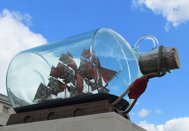
Beside the entrance is a public artwork called ‘Nelson’s Ship in a Bottle’. It was made by BritishNigerian artist Yinka Shonibare and it used to stand on the fourth plinth of Trafalgar Square. The ship inside is a model of HMS Victory, the ship Nelson died on at Trafalgar. The colourful sails feature Indonesian ‘batik’ designs. Textiles like these were made in the Netherlands and traded in West Africa by British merchants. The work therefore explores the international legacy of Britain’s maritime empire.
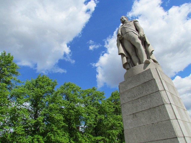
Continue up to the statue of of a man standing on a plinth (King William IV).
14 Sailor Bill
This statue is of another contributor to Greenwich’s maritime heritage. King William IV was another of Britain’s Hanoverian kings. He was the youngest of George III’s fifteen children and ruled Britain, Ireland and Hanover from 1830.
William IV was often known as the ‘Sailor King’ or ‘Sailor Bill’ because from age 13 he served in the Royal Navy. Before he became king, he was the Navy's Lord High Admiral. In this role he improved the Royal Navy’s provisions and introduced their first steam-powered warship.
He fought at the Battle of St Vincent against the Spanish and was the target of a planned kidnap in New York during the American War of Independence. He also sailed alongside Admiral Nelson and spent time in Antigua and Barbuda as well as attending Nelson’s wedding in Nevis.
William’s wife, Queen Adelaide, gave her name to Adelaide in South Australia. The king however lived for twenty years with an Irish actress, Mrs Jordan - and they had ten illegitimate children.
From the statue cross the road at a safe place and continue into Nevada Street. At the end turn right and continue along Stockwell Street. Use the traffic islands to enter the grounds of St Alfege Church. Make your way to the clock tower and stop in the grassy area outside.
15 Explorers, traders and soldiers
St Alfege Church is named after a former Archbishop of Canterbury who was kidnapped and murdered here by Viking raiders in 1012. The floor inside contains a memorial stone that apparently marks the spot. A church has stood on this site for over 1,000 years. The current building was completed in 1714 to a design by Nicholas Hawksmoor.
The church has a rich maritime history. Countless local people, plus enslaved Africans and Indian seamen were baptised or laid to rest here. One of the most notable is General James Wolfe, who lived at Macartney House in Greenwich Park. The back of the church features a painting that dramatises his death at the Battle of Quebec. We will hear more about Wolfe later.
Another General, Sir Charles Gordon, was baptised here. He became a public hero of the British Empire when in 1864 he led Chinese troops in suppressing the Taipeng rebellion against the Manchu dynasty. Following this sustained civil war, during which 20 million people died, Gordon became the only European honoured by the Emperor with the Imperial ‘yellow jacket’. Gordon was killed in the Sudan after the 320-day siege of Khartoum.
The church is also the final resting place of explorer Henry Kelsey. He was the first European to reach the Canadian prairies and sent home descriptions of grizzly bear and buffalo. He lived in Church Street and was buried here in 1722.
Feel free to go inside the church if it is open. When you are ready leave by taking the path at the side. Cross back over the road and turn right. Continue along the right hand side of Stockwell Street and on to Crooms Hill. Follow the pavement uphill alongside the Park. The pavement is very narrow in places and the hill is quite steep, so take your time. Just past King George Street you will see a large church spire on the right. When you see the church, stop opposite.
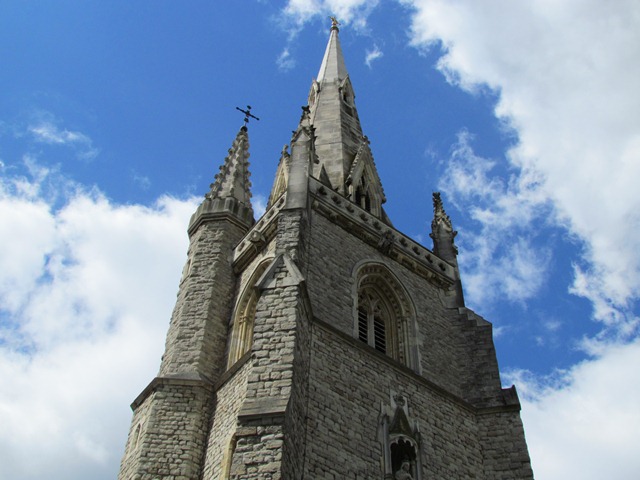
16 Prayer for the decayed
This distinctive church, Our Ladye Star of the Sea, catered mainly for Roman Catholic sailors from the nearby Royal Hospital. At its peak the Hospital housed over 2,000 men injured in Britain’s naval battles. The residents there were referred to as “decayed seamen”!
The church’s congregation included many of the local Irish community, though Portuguese-speaking sailors from the Cape Verde Islands, Brazil, India and Portugal often came to services here. Greenwich’s Irish population increased in the years following the Irish Famine of the late 1840s.
Greenwich’s local Catholic community was encouraged to contribute funds to this new church. Building work began in 1851 and Our Ladye Star of the Sea was completed in 1856.
The interior was designed by Augustus Welby Pugin and holds a dazzling array of decoration that merits quiet contemplation if the church is open. But when the church opened, many of the East Greenwich parishioners were apparently uncomfortable with the ornate Gothic style. So they built their own simpler church, St Joseph’s, which still stands near to the river on Pelton Road.
Keep on the left hand side and continue uphill for about 200 metres. Turn left into Park Walk, a wide gravel path which curves into Greenwich Park. Stop at the round bench and look towards the left. You should be able to see two redbrick buildings in the distance, one with a domed roof the other with a black flagpole with a red globe on it. Stop when you can see these roof tops.
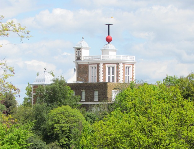
17 Observing the time
We are now in Greenwich Park. It is the oldest of London’s enclosed Royal Parks and the land once belonged to the Flemish monks we heard about at the large anchor. In 1447 it returned to royal ownership.
From here you should be able to see the roofs of the Royal Observatory buildings. We will visit these and hear more about their history a little later. For now take a look at the curious red ball on top of the furthest building, Flamsteed House.
This is the Greenwich Time Ball. Time balls helped sailors to navigate by dropping at the same time every day. This allowed sailors to set their timepieces accurately, which was a vital aid for mariners as it helped them plot their position at sea.
Greenwich’s time ball was installed in 1833 and it drops daily at 1pm. The park’s steep hill meant sailors could see it in the Thames below.
The first time ball was built in Portsmouth in 1829. The development of radio made time balls obsolete though over 60 still survive worldwide.
Turn to the right and find an iron signpost that indicates Queen Caroline’s Bath. Follow this sign and pass Macartney House. Go through the metal gates to stop in the Rose Garden outside the Ranger’s House.
18 Blood and diamonds
This grand building is the Ranger’s House. From 1815 it was occupied by the Rangers of Greenwich Park. ‘Ranger’ was an honorary position for the aristocracy - they did not pick litter or discourage barbeques!
Among the residents here was Viscount Wolseley, a British Army officer who served throughout the Empire including China, Canada, the Indian Mutiny and the Crimean War in the Ukraine. Today the house is run by English Heritage and showcases nearly 700 works of art.
The collection was amassed by Julius Wernher, a German-born businessman and financier. Wernher made his fortune in the 1880s dealing in diamonds in South Africa. In the diamond mines indigenous people were employed in conditions which set the foundations for the twentieth century apartheid state.
Julius Wernher’s Wernher-Beit Company worked in partnership with Cecil Rhodes, the founder of colonial Rhodesia which later became Zambia and Zimbabwe. On his death in 1912 Wernher left a fortune of £12 million. Funds were left to Imperial College London and to establish a university in Cape Town, South Africa.
Continue through the Rose Garden through a second set of gates. Follow the path for 100 metres up to a small hedged area by the wall on the right. Look for a stone plaque in the wall to the right of Queen Caroline’s Bath.
19 The queen and the composer
This section of wall and Queen Caroline’s sunken bath are the sole remains of Montague House, which was demolished in 1815. Caroline was the wife of George IV. Born in Brunswick in Germany, her life as Queen was filled with scandal.
George IV barred her from appearing in public and she developed a reputation for serial adultery. One of her lovers was her Italian servant Bertolemeo Pergami who joined her on tours throughout Europe.
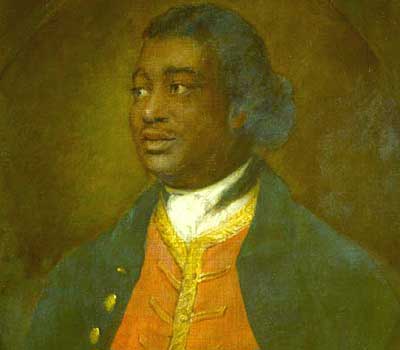
This spot also has a fascinating maritime link. The plaque on the wall commemorates Ignatius Sancho, an enslaved African who obtained his freedom in London.
Sancho was born aboard a slave ship “off the coast of Guinea” and arrived in Greenwich as a baby. He was raised by three sisters as their servant then became a household servant for the Montague family.
Sancho was ambitious. He taught himself to read and write and developed a reputation as a composer. He married Ann Osborne, a West Indian woman of African descent, and they ran a small grocery shop in Westminster. They were well-regarded in London society and had a wide circle of friends from political and literary backgrounds.
Sancho’s book The Letters of the Late Ignatius Sancho, an African was published postumously in 1782. It was one of the earliest books written in English by an African slave. Sancho made a significant contribution to the campaign for the abolition of slavery. He was also the first black person to gain the vote and the first to have an obituary in a British newspaper. His plaque was erected by the Friends of Greenwich Park.
With the plaque behind you go across Rangers Field towards Blackheath Avenue. At Blackheath Avenue, turn left and continue up to a roundabout just before the Tea House. Turn right at the roundabout then in 300 metres take the path on the left. Pass the Roman Temple site on the left and follow the path up to an arched wall gate. Go through it and look across the road at the large redbrick building opposite.
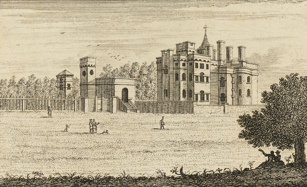
20 Rooms with a view
The extraordinary house opposite with its assorted turrets and spires is known as Vanbrugh Castle. It was built in 1717 by architect and playwright Sir John Vanbrugh who designed many magnificent British buildings, including Blenheim Palace and Castle Howard.
Vanbrugh had a maritime background. He was the son of a merchant who refined sugar from Barbados. Before designing buildings he spent a couple of years working for the East India Company. He also worked as a secret agent for the Dutch Prince, William of Orange, who invaded England in 1688. As a result Vanbrugh was imprisoned by the French as a spy.
On top of the Castle’s conical green roof you can see a gold weather vane in the shape of a duck. This is a sign of the Duckham family, who lived here in the twentieth century. From 1911 Alexander Duckham established a company which developed oil wells in Trinidad. Duckhams Motor Oil soon became a household name.
Alexander was keen on the emerging technology of aviation and was friends with Louis Bleriot, who in 1909 made the first successful powered flight across the English Channel. Duckham paid for a memorial in Dover to mark the spot where Bleriot landed after his 37-minute flight from Calais.
Cross Maze Hill at the traffic island outside the Castle gates. Turn left and continue downhill then stop outside house number 111, a three-storey redbrick building.
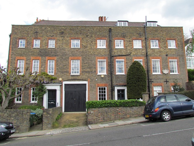
21 The African
This house was the occasional home to a remarkable man - Olaudah Equiano.
As a boy he was taken from his birthplace, possibly Nigeria or South Carolina, and sold into slavery. He spent much of his early life enslaved, briefly in Bermuda then in Virginia before being sold to a Captain Michael Pascal. Pascal gave Equiano the name Gustavus Vassa after a Swedish king.
Under this name Equiano fought in the Navy during the Seven Years War. He sailed in the same ship as General Wolfe to Canada and with Nelson to the Arctic. On several visits to England Equiano stayed here at 111 Maze Hill.
Equiano purchased his own freedom, but only after some devious behaviour by Pascal who had him kidnapped at Deptford and resold into slavery. Equiano had a varied career on merchant and Royal Navy ships. Then in 1789 he wrote his autobiography ‘The Interesting Narrative of the Life of Olaudah Equiano, Or Gustavus Vassa, The African’. It was widely read and had an enormous impact on the campaign to abolish slavery. Before his death in 1797 Equiano worked for the Sierra Leone Company that rehoused former slaves.
Retrace your steps back to Maze Hill Gate. Take the middle path of the three ahead, signposted ‘Café and Royal Observatory’. When another path crosses, continue straight on and uphill to Queen Elizabeth’s Oak. Take the path straight ahead which emerges at the statue of General Wolfe. Pass the statue and go up to the Royal Observatory. Find the clock in the wall then go through a small metal gate to the right. Stop on the brass line in the ground.
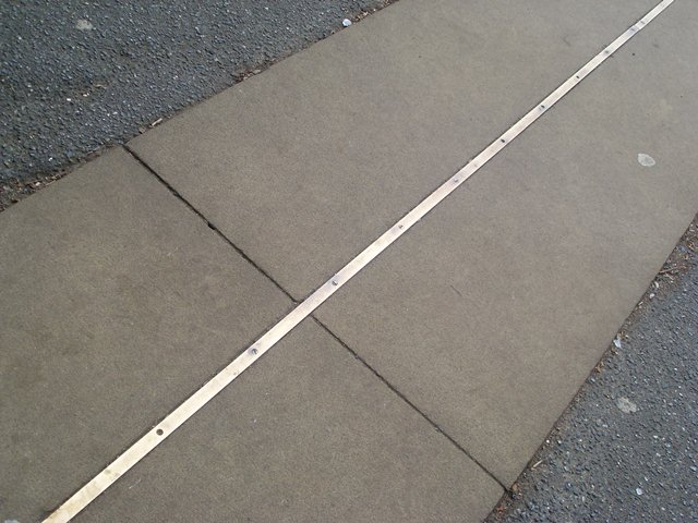
22 The Prime line
We are now at the world-famous Royal Observatory. The original building, Flamsteed House, was built in 1676 for King Charles II. It has played a central role in the development of astronomy and navigation. As well as observing the stars and universe, Greenwich’s observatory helped to create Greenwich Mean Time (GMT) and the Prime Meridian.
Greenwich Mean Time is a global time standard referenced throughout the world. It developed in the 1840s alongside Britain’s railways. With trains running across Britain, a synchronised or ‘standard’ time was needed to create railway timetables.
The Royal Observatory had already been used for time calculations based on tracking the sun - midday of GMT is when the sun passes over the Observatory’s meridian line. Meridians are the black lines on any atlas or globe that run from the North Pole to the South Pole.
While the Equator became established as the halfway point between the Poles, for hundreds of years there was no internationally agreed zero degree meridian between east and west. So in 1884 twenty-five leading nations met to try to standardise a Meridian for worldwide navigation. They voted to make the Greenwich Meridian the Prime Meridian of the world.
The brass line in the wall here symbolises the point where the world’s Eastern and Western hemispheres meet. The Meridian line passes through eight countries; Britain, France, Spain, Algeria, Mali, Burkina Faso, Togo and Ghana. You have to pay to go into Flamsteed House but if you do you can explore a whole universe of history!
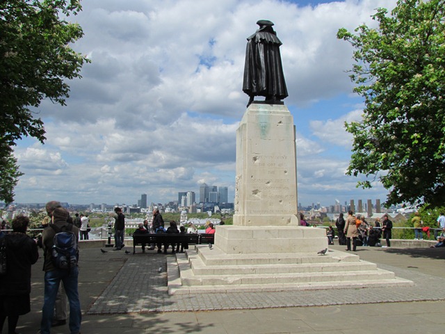
Go back through the metal gate and stop beside the statue of General Wolfe that overlooks the hill.
23 Conqueror of Canada
This statue honours General James Wolfe. Like Admiral Nelson, he travelled across the world and lost his life for the Empire. Wolfe lived in Macartney House in Greenwich Park and was buried in St Alfege Church, both places we saw earlier.
Wolfe fought throughout Europe including in Belgium, Germany and Austria. But he became famous after the Battle of Quebec in 1759. Canada was ruled by France and Wolfe led a daring attack on the French forces. His troops won the battle but Wolfe was hit by three musket balls and died. He became a posthumous hero, known as the ‘Victor of Quebec’. Wolfe’s victory led to Britain gaining control over Canada.
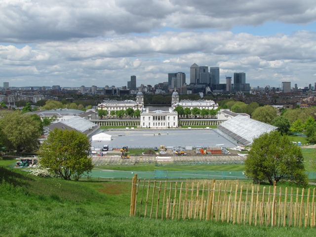
From Wolfe’s statue we can enjoy a spectacular view across Maritime Greenwich and the historic sites we visited earlier; The Queen’s House, the National Maritime Museum, the Old Royal Naval College and industrial East Greenwich. As we have heard, each one of these sites played a part in Greenwich’s maritime history.
For most of 2012 the foreground of the view was transformed. During the Olympic Games, an arena was built behind the Queen’s House for the equestrian and pentathlon events. The pentathlon was designed by Baron Pierre de Courbertin, the French founder of the modern Olympics, to simulate the experience of a cavalry soldier. The competitions are horse riding, shooting, sword fencing, swimming and running.
Walk towards the railings and look out over the view of Greenwich and beyond.
24 A changing view
This view is one of the most famous in London. From here we can see many of the city’s landmarks. From left to right, see if you can spot; the Shard; the 'Walkie Talkie’, ‘Cheese Grater’ and ‘Gherkin’ towers; Canary Wharf; the London Stadium and Orbit Tower; the O2 and the Emirates Air Line.
Immediately across the river, the Canary Wharf financial district makes a fascinating contrast with the Greenwich World Heritage site. Canary Wharf was built on the former West India Docks, which were designed to secure imports of sugar from the West Indies.
Companies based there today include firms from the United States, Switzerland, Hong Kong and Singapore. And people from around the world work there, from traders to cleaners. As a hub of power and influence that attracts people from worldwide, Canary Wharf is like a glass and steel palace mirroring the historic role of Greenwich.
Throughout this walk we have heard how Greenwich became one of the world’s most important maritime sites. We heard about the role of the River Thames and the royal palaces. We heard about people from around the world who lived and worked here: sailors and soldiers, kings and queens, explorers and enslaved Africans.
From this viewpoint we can see how Greenwich has developed - and also what is developing today around it. We hope you have enjoyed the walk.
You may like to explore the World Heritage sites, such as the Royal Observatory, the Cutty Sark, the Old Royal Naval College, the Queen’s House and the Discover Greenwich centre. We also recommend exploring the park and the town, including the Fan Museum on Crooms Hill.
Your browser is out of date, and unsupported by this website. Please upgrade to the latest version to use this website.
'Greenwich Hospital from the North Bank of the Thames' Canaletto (c.1753), Wikimedia (CCL)
Greenwich walk
A walk in the Maritime Greenwich World Heritage Site
Greenwich is one of the world's most famous maritime sites. Home of the Royal Observatory, Old Royal Naval College, the National Maritime Museum and the Cutty Sark, the area attracts thousands of visitors every year.
People have been coming to Greenwich from around the world for centuries. This walk traces Greenwich's development by following the footsteps of sailors and soldiers, kings and queens, inventors and explorers.
Hear how Greenwich grew from a small fishing town to a royal seafaring centre. See Britain's first classical building and the world’s last tea clipper. Stand on the steps that welcomed royalty and the line that divides the Earth.
Follow the walk by clicking on the map pins or downloading the guides below