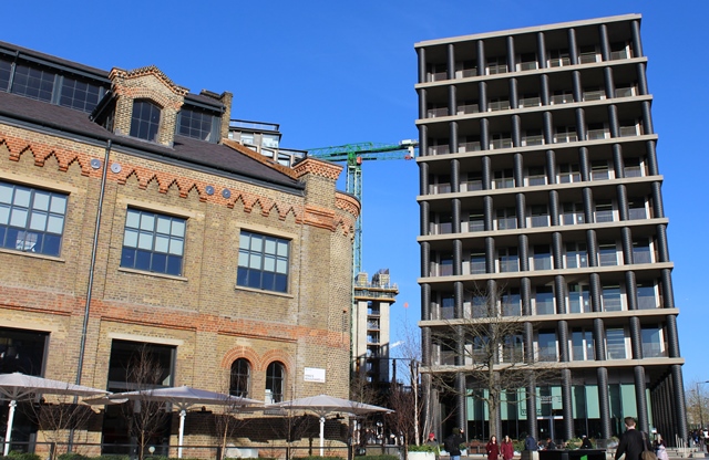
The square in front of us, now a new public space where art, performance and artisan coffee combine, still retains its old name - Battle Bridge. The only battle you’ll see today is jostling commuters dashing for a train. As for the bridge - where’s the water?
This was once a crossing point over the now buried River Fleet – one of London’s lost rivers. It flowed from Hampstead Heath to Blackfriars when unlike today, this area of Kings Cross was not a very salubrious one. Battle Bridge was known for its rubbish heaps, where everything from the contents of dust carts to refuse such as barley husks from breweries were dumped.
Today it feels like we’re in the heart of the metropolis but until the 19th century London ended at the British Museum and St. Pancras was a tiny hamlet which sat alone in open country surrounded by fields. In 1704 Jonathan Swift parodied the inhabitants of St. Pancras Fields as being "innocent of London as if they were inhabitants of Berkshire.”
The new transport era that would turn a rural parish into an industrial hub began less than a hundred years later when the Regent’s Canal was dug through St. Pancras Fields in the early 1800s. Demolition for the three great railway termini – Euston, King's Cross and St. Pancras – that now dominate the area began in the 1830s and changed this area forever.
Directions
Cross St Pancras Road at the pedestrian lights, and enter St. Pancras Station. Walk straight through the station concourse and out on to Midland Road. Cross over the road and turn right past the Crick Institute then take the first left into Brill Place. Walk up Brill Place (which becomes Phoenix Road) then turn right at the Cock Tavern onto Chalton Street. Stop at the junction of Chalton Street and Polygon Road by the round tower of a modernist housing estate.
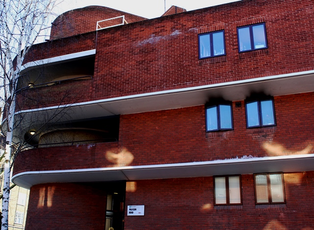
2 Polygon Road
If you look at a map you'll see this is Somers Town.
The place you're standing now was once called Clarendon Square. If you look at the accompaning picture you’ll see how it used to look.
The building on the left was part of the Polygon, the first housing to be built in Somers Town in 1784, when it stood amid fields and market gardens on the northern edge of London. Today all that remains of this old neighbourhood is the street name. But why?
The Earl of Southampton who owned much of the land developed as Covent Garden and Bloomsbury also owned the land known as Somers Town, next to St. Pancras Station. While those two neighbourhoods became fashionable, Somers Town ended up literally on the wrong side of the tracks. Houses quickly became slums, and the residents included beyond-the-pale radicals including proto-anarchist William Godwin and his wife, pioneering feminist writer Mary Wollstonecraft.
It was here in Somers Town, that Mary died giving birth to her daughter, Mary Shelley. Living here, Mary Shelley witnessed the effects that rapid industrialisation had on the workers. Some feared it was turning them into machines. Out of this idea her great novel Frankenstein was born.
Construction of the railway affected Somers Town badly and accelerated its descent into poverty. Major construction work continued for much of the 19th century, with a large chunk of Somers Town demolished for the goods depot and potato market. Today much of the neighbourhood is buried under the British Library and the Francis Crick Institute.
Directions
To find the plaque to Mary Wollstonecraft continue up Polygon Road with the Oakshott Estate on your left, turn left at the end onto Werrington Street, and where a set of stairs rises above a garage entrance, it’s on the wall halfway up the steps. To continue on to stop 2, walk back down Polygon Road (the way you came) crossing over Ossulston St and following the pedestrian path to emerge at Purchese St. Go left then take a right on Chenies Place until you reach Pancras Road. You'll see Old St. Pancras Churchyard on the other side of the road. Cross over and wander round the churchyard.
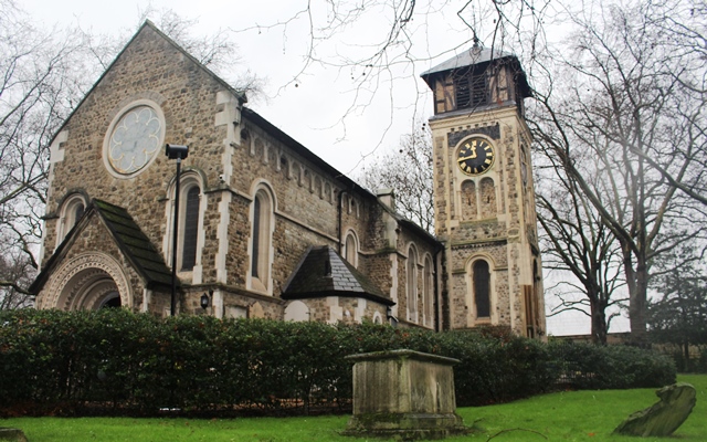
3 St Pancras churchyard
If this feels like a small country church (compare it to Hawksmoor and Wren’s much grander London churches and cathedrals) then that’s because it is, or at least it was when it was built.
St. Pancras Church is said to be one of the oldest in England. A minor industry has developed around debating its age. Some people even claim the church is the earliest in the country. An altar slab was found in the 1840s with inscriptions thought to be 7th century, but this has since been dated to the 1400s. In any case the current church is mostly Victorian, but the peculiar isolation of this spot gives credence to the idea that it belongs to another time.
Dr. William Stukeley - an 18th century antiquary, clergyman, Freemason and a self-declared druid - developed imaginative (and widely reproduced) theories about St. Pancras. He claimed that Julius Caesar’s army camped on the Brill, a hill to the west of St. Pancras Old Church, during their British campaign of 53-54 AD. The Brill is now lost under Somers Town, although Brill Place still exists as a street name.
Notice that the church sits on raised land above the streets around it. It was deliberately built to be above the flood valley of the River Fleet.
Even so, the congregation was sometimes forced to abandon their worship to escape ‘the foul’d and great water of the Fleet.’
We know too there was a small village here in the 13th century with around forty houses. It seems to have been an isolated spot for a long time. John Norden, writing in the 1590s, describes St. Pancras Old Church as being in a bad state of repair but says “Yet about this structure have been many buildings, now decaied, leaving poor Pancrast without companie or comfort.” He adds “Walk not there too late”, claiming that it was forsaken by everyone except thieves.
Directions
Walk through the churchyard, keeping the church on your right, and exit through the back gate leading to Camley Street. Turn left and follow Camley Street over the Regent's Canal to the junction with Barker Drive and wander a short way into the housing estate.
4 Barker Drive off Camley Street
Barker Drive is part of Elm Village, now an unexceptional 1980s estate but also the site of Agar Town, a notorious lost neighbourhood once known as 'Ague Town'.
In the 19th century this area was transformed from fields to houses, houses to slums, and slums to railways, wharves, markets and coal depots in the space of just thirty years. Agar Town was part of a tide of jerry building that swamped the area in which houses were cheaply built using poor quality materials and let on short leases which encouraged exploitative landlords. It was said to resemble a shanty town, without paving, drainage or street lighting and with a gasworks, but no gas.
Worthies queued up to condemn it. The Vicar of St. Pancras proclaimed “The houses were of the most wretched description, more fitted for the occupation of wild beasts than for human beings.” Journalist W.M. Thomas concluded that “In Agar Town we have, within a short walk of the City…a perfect reproduction of one of the worst towns in Ireland.”
In the face of such views, Agar Town was doomed. It only existed for twenty years before it was sold to the Midland Railway Company in 1866 and demolished, to be replaced by coal depots. Conditions were bad but there was also snobbery involved. There were clear social divisions between Agar and Camden and Kentish Towns to the north, where the houses were larger, better-built and much more respectable.
Meanwhile, Agar Town is remembered for working class heroes Dan Leno and Tom Sayers. Leno, king of the music hall, was born there in 1861. Tom Sayers, the boxer, was living in Agar Town when he achieved instant fame in 1860 winning the first official heavyweight title fight, despite a broken arm. Agar Town is commemorated only by Agar Grove, on the route to the next stop.
Directions
Continue along Camley Street, following it under a railway bridge and then up a ramp to Agar Grove. Turn right and then take the second right into St. Paul's Crescent. Follow the road to the end in the Maiden Lane Estate, and then climb steps ahead and a little to the left (by the community centre) on to a raised platform area overlooking the railway tracks.
5 Maiden Lane Estate
This vantage point is a good spot to look out over the rapidly changing Kings Cross. Unlike some parts of the city where you can still get a sense of the past, it's almost impossible to picture what is was like even a hundred years ago...
The 1980s built Maiden Lane Estate which you've just walked through, was constructed over railway sidings once used by the Metropolitan Cattle Market just to the north of here. This was London's new, modern cattle market built in the 1850s to end the practice of live slaughter at Smithfield, which was too much even for filthy, crowded Victorian London.
The market was built around Copenhagen Fields, an open space of land used as a tea garden with skittles, fives, dog-fighting, bear-baiting, pigeon-shooting, races, boxing, wrestling and cricket. Its licence was revoked in 1816 for illegal bull baiting and dog fighting.
Copenhagen Fields was also a popular venue for protest and demonstrations. Most famously, it was the site of the Tolpuddle demonstration in 1834. Here a crowd of up to 100,000 protested against the sentences of transportation handed down to the Tolpuddle Martyrs, Dorset agricultural labourers accused of forming an illegal trade union. Protestors gathered 200,000 signatures on a petition, and eventually the martyrs were brought back from Australia
By 1855 Copenhagen House had been demolished, making way for the new market. It was a huge undertaking, “a monster live-stock emporium” constructed at enormous expense. The original market had pubs at each corner, two hotels, twelve banks and its own telegraph office. Every week 25,000 sheep and 5,000 oxen were sold, not to mention calves and pigs. Animals were offloaded from trains at Maiden Lane, and livestock driven along the streets to the market. No trace of the market is left behind today except for the centrepiece clock tower still looming over the Caledonian Road.
Try to keep these images of noisy cattle markets, bear-baiting and mass protests in mind as you discover an area rapidly undergoing 'regeneration'.
Directions
Walk back down the steps to ground floor level, turn right, and then turn first left along a walkway through the estate. At the end turn right along a back street with parking, Maiden Lane. At the end of Maiden Lane, turn right and cross York Way. Walk downhill to the junction with Vale Royal on the left (just before a railway bridge).
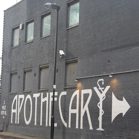
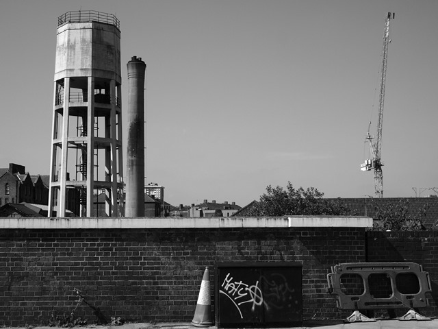
6 Vale Royal
Wander a little way down Vale Royal and stop opposite the brick and green metal industrial building. Notice it still has a crane and a ‘taking in’ door for lifting heavy goods into what was presumably a factory or warehouse.
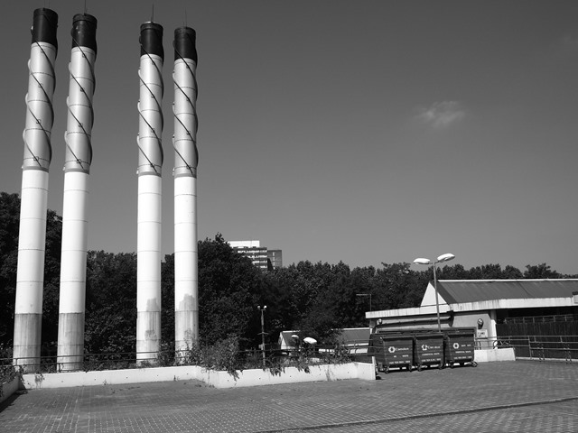
Today the miniature neighbourhood of Belle Isle is a few unremarkable streets, a disregarded industrial corner that used to host even less pleasant activities. In the 19th century Belle Isle contained refuse yards, knacker’s yards, chemical works and manure factories, a coal depot, a carpet beating and cleaning factory and the St. Pancras Iron Works. In the 1890s it was said that Belle Isle “is now and always has been the chief seat of the London horse slaughterers.” The phrase “It stinks like Belle Isle” was used locally. It's hard for us to imagine today just how foul smelling and dangerous it must have been.
The streets nearby were home to cabmen, carters, navvies, and porters. In the 1840s Belle Isle was also the location for the Experimental Gardens, known as Frenchman's Island. The Frenchman in question was Peter Baume, an eccentric who formed a utopian community where poor people could build cottages. He attracted a number of radical tradesmen, including tailors, shoemakers and their families. By 1851 there were 48 families living on the site, farming the land.
The community attracted hostile attention, however, and missionaries fought the influence of the 'infidel Frenchman'. Sanitary inspectors condemned the open drains. Then the railways arrived, with the Great Northern Line tunnel on one side and the North London line on the other. By 1853 the community had gone, and it was not long before passengers passing trains were complaining to the Board of Health about the stench of the knacker's yards.
Belle Isle remains an industrial pocket in a changing area. Its main street, Vale Royal, is an ordinary street with an extraordinary myth. William Stukeley claimed the area as the spiritual centre of England, where Brutus founded “New Troy”, the site of the palaces of pre-Roman kings of Britain. Could the key to Albion be hidden away here, among the workshops, the warehouses and nightclubs?
Directions
Continue along York Way under a series of railway bridges, to the junction with Bingfield Street on the left.
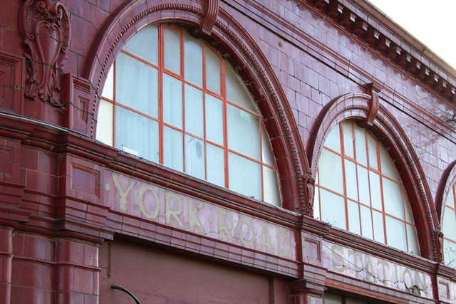
7 York Road tube station
Behind a fence, resplendent in ox-blood tiles, is the long-closed York Road tube station.
It was once a stop on the Piccadilly Line between King's Cross and Caledonian Road, but the poor and industrial neighbourhood meant the station was never well-used. It closed in 1936 and remained marooned behind King's Cross for decades until development reached the area. Now more and more flats are being built every day bringing potential passengers, but York Road remains resolutely closed.
Another lost station, King’s Cross York Road, was further along York Way on the other side. It was used by local trains until demolition in 1977.
The area between here and King's Cross Station, visible on the other side of the road, was the site of the King's Cross Railway Lands. This was a maze of sidings, sheds, turntables and coal chutes belonging to the railway companies.
It was effectively a docklands area, providing an interchange between railways and the canals that brought coal for the engines and goods for transfer. The site became disused in the late 1960s at the end of the steam era, and the Railway Lands entered a long period of dereliction.
King's Cross had become a byword for seediness, the station known for prostitution and drug dealing as well as for a popular clubbing scene which grew up in the disused warehouses.
The area behind the station featured as the backdrop for scenes of urban decay in classic 1980s films such as Mona Lisa.
Directions
Continue along York Way, then turn first right along Handyside Street. Take the first left through the former railway sheds, into Granary Square and stop here by the fountains.
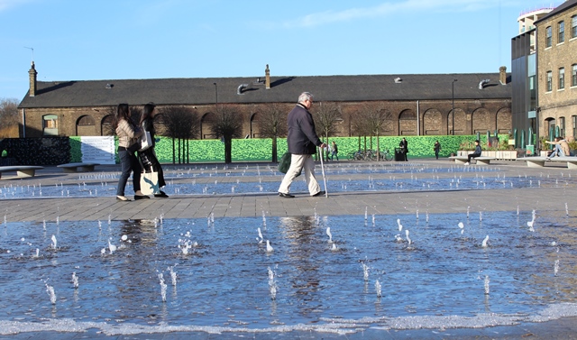
8 Granary Square
This brand new architect-designed square sits at the heart of the Kings Cross redevelopment. Once a store-house for wheat brought from Lincolnshire to the bakers of London it now houses the Central St Martins Art College. A thousand choreographed and lit-up fountains create a playful new public area.
We’re almost at the end of the trail around Old St Pancras. As you walked around today, did it feel much like a ‘neighbourhood’ to you? St. Pancras is still a maze of apparently unrelated places, separated by the sprawling railway structures that split the neighbourhood apart at the height of the Industrial Revolution.
The King’s Cross Central development has taken 40 years to agree, but is now turning the old railway yards behind the station into offices, flats and shops. The new buildings have erased the previously seedy reputation of King’s Cross and St. Pancras, and sent property prices soaring, but Elm Village, the Maiden Lane Estate, Belle Isle and Copenhagen are as much off the radar as they ever were.
The obscurity of places so close to London's busiest streets seems strange, yet the railway has made this swathe of London remarkably hard to find or access. However, change is afoot as workshops and industrial spaces start to vanish, and are replaced by housing, much of it for students. London never stands still, so the time to see Old St. Pancras in its forgotten glory is sooner rather than later.
Just a stone’s throw from Kings Cross station is a set of little-known neighbourhoods, bypassed by the vast majority of travellers.
Elm Village marks the site of Agar Town, once claimed as London's worst slum. Nearby, London's largest meat market flourished in the 19th century on Copenhagen Fields. Belle Isle boasted some of London’s most antisocial industries, but also a mythical past.
On this short walking trail, discover the stories behind these lost neighbourhoods and uncover a world hidden away on the wrong side of the tracks.
Follow the trail by clicking on the map pins or downloading the guide below

 © British History Online")


.gif "Paradise Row in Agar Town 1854 © Wikimedia Commons")