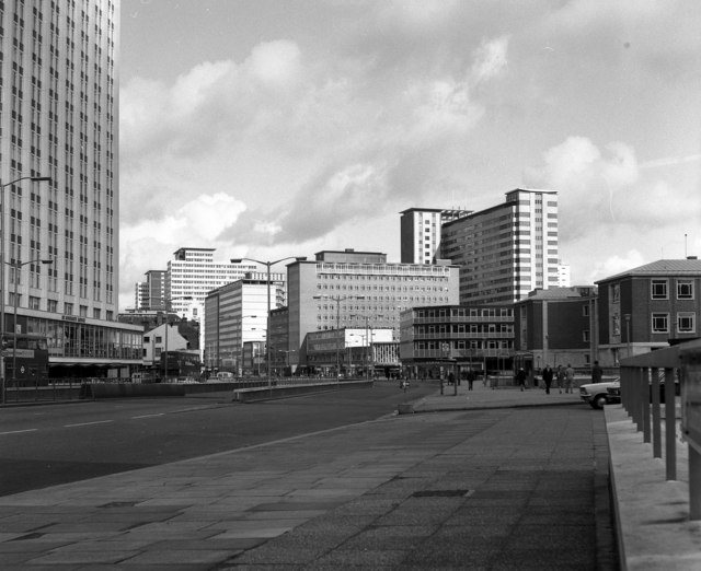
Where better to start our journey around Croydon than at No.1? No.1 Croydon is the official name of this distinctive tower block. At 269 feet (82 metres) tall, it stands like a lighthouse over East Croydon station's sea of passengers.
Take in the building’s distinctive shape. Like iconic towers in central London - including 122 Leadenhall Street (the ‘Cheese Grater’) and 20 Fenchurch Street (the ‘Walkie Talkie’) - this one too has a nickname. It’s known as the ‘50p Building’ (and as the ‘Thrupenny Bit’ before decimalisation) as it resembles a stack of multi-sided coins.
Opened in 1970 as an insurance company office, for many years this was Croydon’s tallest building. It was designed by architect Richard Seifert and embodies a period of towering ambition.
Though London is England’s capital city, two districts within it also have city status. They are the City of Westminster and the historic City (or ‘Square Mile’) around St Paul’s Cathedral. From the late 1950s ambitious planners hoped to make Croydon the ‘third city’ of London.
This suburban town was transformed. Tower blocks sprouted into the air, while underpasses and flyovers scythed through the streets. But Croydon was singed for reaching towards the sun. As the town’s skyline rose, its image sank. City status was never granted and the developments became symbols of a lost age.
What do you make of this tower? Fans have tried to protect it as a listed building while opponents would rather see it demolished. Love it or loathe it, it remains a local landmark.
The tower even appeared in the opening credits of the TV sitcom Terry and June. Croydon’s critics say this is rather apt. The town is often seen as a bit of a joke. From The Hitchhiker’s Guide to the Galaxy to Peep Show, Croydon is a recurring punchline in popular culture.
But should it be? This tower is perhaps symbolic for other reasons. Like Croydon overall, it’s bold and brash, distinctive and divisive - and ultimately misunderstood. Let’s explore why.
With your back to the tower and with East Croydon station on your right, go downhill along George Street. Take the first right turn into Dingwall Road. When you reach a roundabout keep straight ahead (passing the Corinthian House office block on your left).
After a short distance find a safe place and cross over Dingwall Road. Continue along the left hand pavement. Cross the junction with Sydenham Road then almost immediately turn left into Bedford Park. Follow this road all the way to a very tall tower covered in coloured squares. Stop when you have a good view of this building.
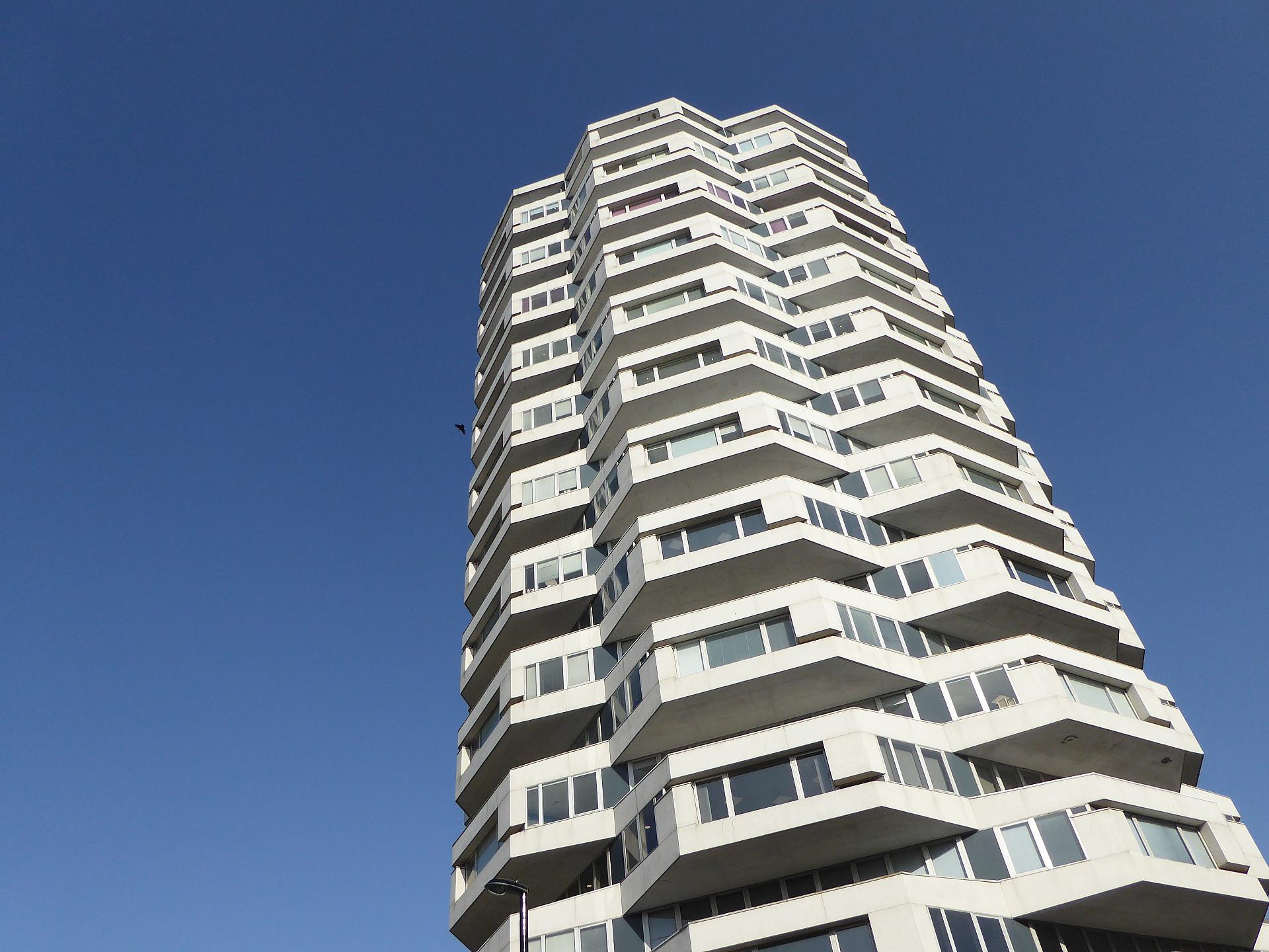
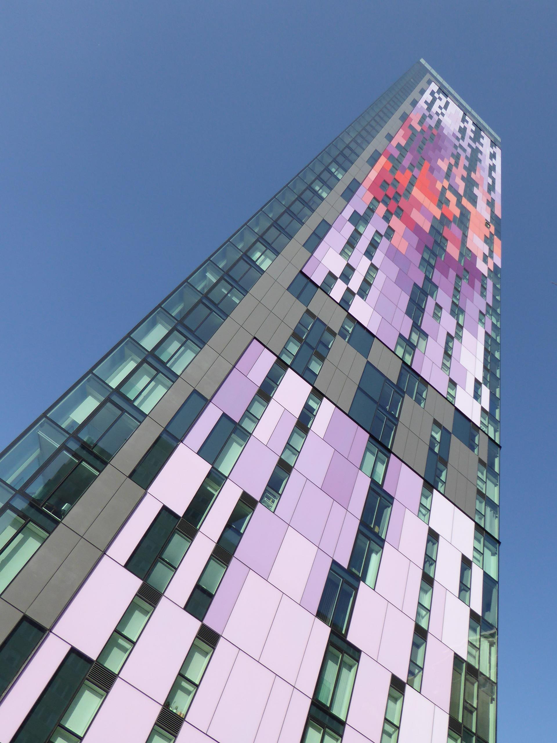
2 Saffron Tower
This is the Saffron Tower. At 500 feet (152 metres) it’s superseded No.1 as the town’s tallest.
In 2016 it was nominated for the annual Carbuncle Cup, an architecture magazine award for Britain’s ugliest new buildings. Judges described it as “a multi-coloured monstrosity”. Do you agree?
This block of luxury flats is part of the Croydon 2020 Plan to regenerate the town. Key to the plan is new housing. Croydon’s population is around 381,000 - larger than Cardiff, Coventry or Iceland - and still growing. Some estimates suggest there will be another 35,000 Croydon residents in the next 15 years.
The major reason is that Croydon is just ten miles from central London. As a large commuter hub, it offers easy access to London but cheaper living costs. Croydon’s location means it has capitalised from the capital for centuries.
The Saffron Tower reveals how the relationship first blossomed. Look up at those colourful panels. They are meant to recall a crocus plant. Croydon’s name comes from the Anglo-Saxon words ‘croh’ (crocus) and ‘denu’ (valley).
Dried crocus petals are the source of saffron, an expensive spice used in food, dyes, and medicine. Like Saffron Walden in Essex, Croydon was once a centre of saffron cultivation.
Crocuses are delicate, thriving best on sunlit sloping land. Besides being close to London, Croydon is in a valley at the edge of the North Downs. The Downs are a large chalk ridge that sheltered the valley from prevailing winds.
Chalk is a ‘porous’ rock, which means water drains through it. This allowed a series of springs and the River Wandle to emerge nearby, providing the crocus growers with plenty of water.
Croydon’s newest tower reflects the town’s rural origins. As we continue we’ll uncover more echoes and ripples of Croydon’s past showing through the modern town.
Keep the Saffron Tower on your right and continue around it to the pedestrian crossing outside Tesco Express. Use the lights to cross over the busy Wellesley Road. Turn left and cross over the end of Station Road - use the traffic lights here too as this road is a busy bus and tram route to West Croydon station.
Continue back along Wellesley Road (so that the Saffron Tower is now on your left). Next, turn right into Poplar Walk. At the end, use the crossing to turn left into a wide pedestrianised shopping street.
Continue the whole length of this street and stop at the last building on the left hand side. It is made in brick with tall thin chimneys.
NOTE: At the time of creating this route there were major roadworks and pedestrian diversions on Wellesley Road. Please follow diversion signs carefully to cross over it.
3 Whitgift Almshouses
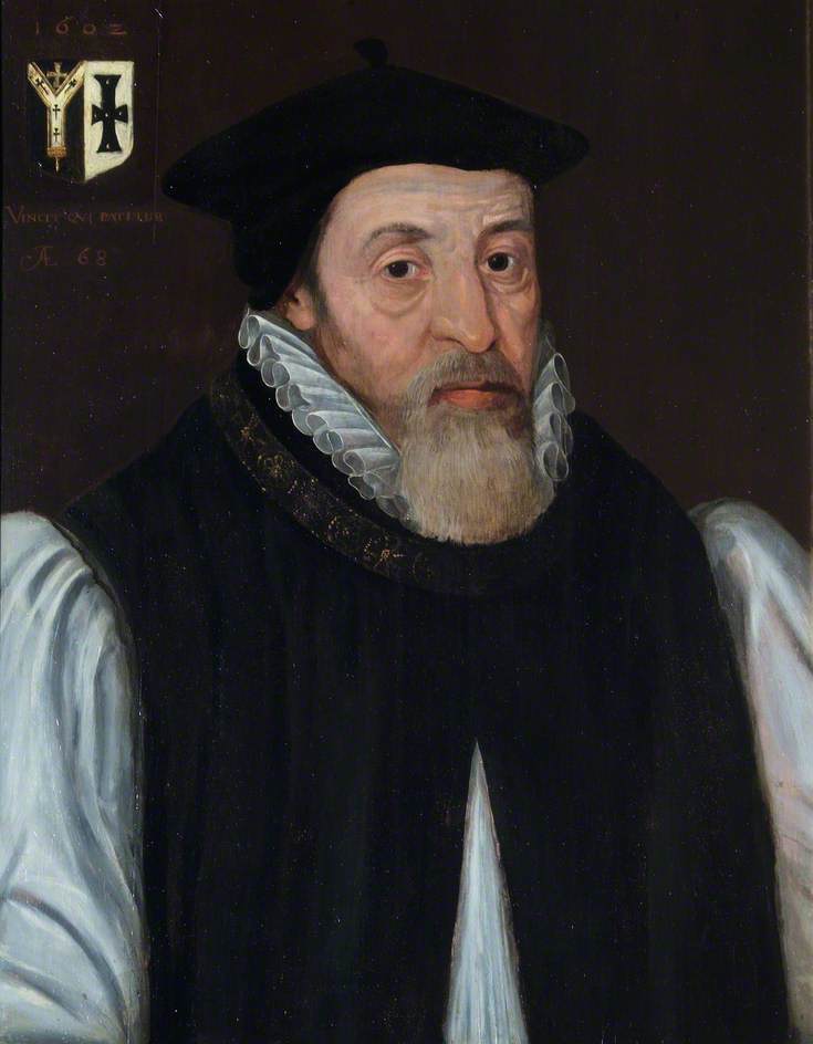
At first glance this busy shopping street may seem thoroughly modern. Tucked beside the glass and chrome shopfronts though are the Tudor bricks of the Whitgift Almshouses. They were built in 1596 by the then Archbishop of Canterbury, John Whitgift.
Hidden in plain sight in Croydon’s commercial heart, the almshouses are a clue to an earlier spiritual status. From at least the 900s Croydon was one of England’s holiest places. The reason was the town’s geography.
The senior bishop in the Church of England is the Archbishop of Canterbury. The early Archbishops lived near Canterbury Cathedral but regularly travelled to London to their official home, Lambeth Palace. In Tudor times and earlier journeys between London and Kent took a few days by horse.
As a result the Church built a chain of palaces along the route, including one in Croydon. As the nearest one to Lambeth, Croydon Palace made an ideal weekend and summer retreat. For over 500 years, Croydon Palace was the Archbishops’ official summer residence.
John Whitgift was the Archbishop from 1583 to 1604. He stayed in Croydon many times and grew fond of the town. In Christian tradition ‘alms’ are money or services to support poor people. Whitgift’s almshouses provided Croydon’s “poor, needy and impotent” with somewhere to live.
His legacy also lives on in the nearby Whitgift School. Similarly, Croydon maintains strong ties with the Church. A minster (a large regional church) was founded in Croydon around 960. Look for a sign on the wall of the almshouses pointing towards the Croydon Minster’s square tower on the horizon.
Croydon has its own bishop and eleven of the Archbishops still rest here. Six of them - including Whitgift – are buried at the Croydon Minster. Another five were buried at St Mary’s Church in nearby Addington.
Pictures:
Archbishop John Whitgift / Croydon Palace c.1785 Wikimedia Commons (CCL)
Directions
With the almshouses on your left carefully cross the road – watch for trams again here. Turn right and head downhill towards the Minster. Take the first road on the left, Middle Street, and then turn right into a narrow cobbled lane (Bell Hill). At the end turn slightly left into Surrey Street. Stop outside The Dog and Bull pub.
4 Surrey Street
We are now in the narrow lanes of Croydon’s Old Town. The colourful stalls here on Surrey Street trade six days a week. Surrey Street Market is thought to be one of the oldest in Britain.
Croydon was granted a market charter in 1276 but its origins may date from even earlier. On the way to the almshouses did you notice how straight our route was? We followed part of a Roman road that runs from London to Portslade, near Brighton.
With the Roman road bringing Croydon constant footfall, a market grew alongside it. By medieval times Croydon's market was held in a large triangle-shaped area in the slope of the valley. It spanned several of today's streets and traders made the most of the natural landscape.
Notice we’ve travelled downhill since we left the almshouses. Well-drained higher ground was used for storing and selling corn. Low-lying Surrey Street meanwhile was originally called Butchers Row after its livestock trade.
The Dog and Bull is Croydon’s oldest pub, with claims it dates to 1431. Its name is a clue to the market’s activities. The beer garden was where stray dogs and market cattle were kept in a pound. Pens of live animals, racks of meat, drying blood trickling through the cobbles...imagine how this area would have felt.
Take time to explore the market’s sights, sounds and smells. These stalls are the forerunners of the offices and shopping centres that make Croydon the third-largest business district in Greater London (after the City and Docklands).
Many of the buildings, with their sash windows and red bricks, are Victorian or later. Why doesn’t the Old Town look very old? Let’s find out…
The oldest known map of Croydon, c.1785 - the site of the market is the triangle shape in the centre Wikimedia Commons (CCL)
Directions
With the pub on your right continue a short distance. Look on the right for a cobbled square with a castle-like building in it. Go into this square and stop by the building.
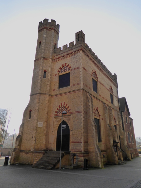
5 Surrey Street Pumping Station
With its turreted tower and arched windows Surrey Street Pumping Station looks rather like a castle. Tucked away and easily missed, this curious building reflects Croydon’s rapid growth. Between 1801 and 1901 Croydon’s population exploded from 5,000 to 134,000.
As so often happens, Croydon was shaped by London. When London became a major industrial city from the late eighteenth century, its surrounding towns became places to escape from the factories and smog. Croydon was a popular choice.
The art critic John Ruskin was born and grew up here. He described 1820s Croydon as a green gateway to the countryside, “modest, humble and pure in peace”. Such serenity encouraged many people to move to the town.
But Croydon began to industrialise too. The River Wandle powered several mills, which produced beer, leather, corn, flour and tobacco. Many of these trades polluted the water. When the Archbishops moved out of Croydon Palace for sanitary reasons, the site became a bleaching factory.
Croydon's growing industries attracted new workers, many of whom settled in the Old Town. By the 1840s the sylvan ‘crocus valley’ became an overcrowded slum.
To stem the flow, Croydon’s authorities set up Britain’s first Board of Health. Formed in 1849 they built sewers and drains to improve sanitation. This pumping station provided residents with clean water.
With the ornate tower on your left, look behind it for a darker house-shaped building. This used to stand on the other side of town, where before it pumped water it pumped air for an ‘atmospheric’ railway.
Atmospheric railways used trackside air pressure to drive the trains. An atmospheric line was built from Croydon to Forest Hill, with pump engines at each end. Expensive and unreliable, the line soon closed. The Croydon engine house was dismantled then reassembled here brick-by-brick.
Such social innovations helped Croydon gain Unitary Borough status in 1889. This gave the town authorities more powers, including over transport and planning. In the following decades much of the Old Town was cleared and rebuilt. A new era began.
The Forest Hill atmospheric pumping station c.1845 Wikimedia Commons (CCL)
Directions
Return to Surrey Street then turn right. At the Green Dragon pub, turn sharp left to double back onto the High Street (look for a large stone plaque in the wall that records when the High Street was widened). Follow the road as it sweeps 90 degrees right and use the pedestrian crossings to reach the Town Hall, a large redbrick building with a clock tower.
Keep the Town Hall on your right and continue into the gardens beyond. Follow one of the paths to the left until you can see a sunken area with a large wall.
6 Queen’s Gardens
The ornate Town Hall and Clock Tower show off Croydon’s confidence as a progressive Victorian town. The Queen’s Gardens beside them are a pleasant space. But the flower beds have strange roots.
With the Clock Tower behind you, look at the shape of the land to the left. Does the deep trench remind you of anything?
The lower gardens are a former railway cutting. In their early years, Britain’s railways were built by competing companies that ran separate lines. Rapidly expanding between London and the south coast, Croydon was ripe for railway speculators. By the 1840s it had three stations.
These stations were far from the town centre though, so in 1868 another one opened on the site of the Town Hall. It was called Croydon Central. The tracks ran through the cutting and passed where the Fairfield Halls are now.
Sporadic trains meant Croydon Central shut twice and was then demolished. A plaque on the wall records how the gardens were created afterwards. This ghost train isn’t Croydon’s only lost link.
Transport constantly evolves to save time and make money. Croydon’s location placed it to the front of advances.
Croydon was part of the world’s first public railway. Opened in 1803, the horse-drawn Surrey Iron Railway ran from Croydon to Wandsworth. It was soon superseded by steam trains, though today’s trams still use part of the route.
The town also had the world’s first international airport. Croydon Airport was built for the military during the First World War. Passenger flights to Europe took off from the 1920s. Pioneer aviators and wealthy travellers made Croydon famous and glamourous worldwide.
The airport became too small and enclosed however for increasingly large jet planes. Surpassed by Heathrow, it shut in 1959. The last plane has flown but we can still see the airport’s legacy in Croydon’s skies.
Croydon Central Station platforms Wikimedia Commons (CCL)
Passengers boarding a 'Heracles' aeroplane at Croydon Airport, 1930s Wikimedia Commons (CCL)
Directions
Go into the lower gardens (there are steps or a path to choose from). With the Clock Tower behind you, exit the gardens by going through the short tunnel under the road. You will emerge near the Fairfield Halls and across the road from a tower block with ‘Nestlé’ written on the top end wall. Continue past the bus stops and stop opposite this building.
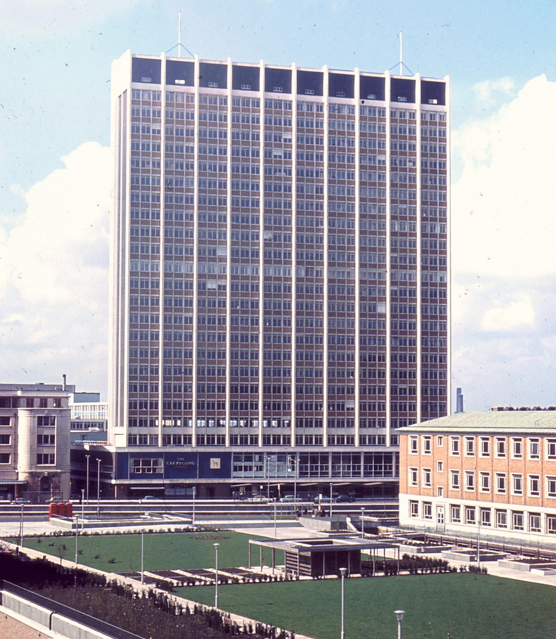
7 St George’s House
This tower, officially called St George’s House, is commonly known as the Nestlé Building. Until 2012 it was the Swiss company’s UK headquarters. The end wall still carries their familiar logo, with its trio of birds. Their abandoned nest sings a surprising song.
At 79 metres (259 feet), this is yet another tower that was once Croydon’s tallest. We’re going to concentrate on the ground floor though. Look there for a boarded-up blue building. This was The Greyhound pub - one of Croydon’s lost live music venues.
In its heyday The Greyhound hosted rock royalty. Jimi Hendrix, Led Zeppelin, Deep Purple, Black Sabbath, David Bowie, Lou Reed, Roxy Music, Queen, Elton John, Status Quo, Genesis, Thin Lizzy, Buzzcocks, Siouxsie & The Banshees, The Jam, The Ramones, AC/DC, Talking Heads, A-Ha - and many others all played here.
It wasn’t just music that blew people away. Through the tower’s ground floor is an arcade of shops. The shape and position of St George’s House pushed air downwards to the street and turned the arcade into a wind tunnel. Passers-by were often knocked over by sudden gusts.
The problem is known as ‘downdraught’ and still occurs around today’s skyscrapers. To stop it around St George’s House engineers fitted a roof over part of the arcade and ‘baffles’ (low walls) along the pavements.
St George’s House was one of over 40 tower blocks that sprang up in Croydon during the 1960s. They rose from the ashes of the Second World War. During the war Croydon Airport was a major RAF station and became an enemy target. Nazi orders were “to bomb it to a finish”.
The town also suffered for being near to London. Enemy bombs and rockets aimed at the capital often fell short and hit Croydon instead. From August 1940 to June 1941, 1,338 bombs landed on Croydon - 362 people were killed and over 1,000 houses destroyed.
For several years afterwards much of Croydon needed rebuilding. Given a blank sheet of paper, the town’s planners left signatures that are still visible today.
Fire fighters during a Second World War bombing raid on London Wikimedia Commons (CCL)
Directions
With St George’s House on your left, continue past Croydon College. Carefully cross College Road on the right and go up to the Sainsbury’s on the corner of a major junction. This junction is very busy, with lanes for trams and buses, so please follow these directions carefully.
With Sainsbury’s to your right, use the traffic lights to cross the first part of the road ahead. Stop on the island and use the next set of lights to cross over one set of the tram tracks.
From this island (opposite Barclays bank) turn left. Use the traffic lights here to cross over a bus lane. Go into the pedestrian island with two large flower beds. Stop in this space and turn right to face the Saffron Tower on the horizon.
8 Wellesley Road / George Street traffic island
We’ve nearly come full circle on our trail - look around and we can see the No.1 and Saffron Towers where we began. This spot between them, a traffic island on Wellesley Road, might seem an odd place to finish.
Much of what we can see is the legacy of Croydon’s post-war transformation. Besides the forest of tall buildings, notice the road layout. There are multiple lanes. An underpass echoes beneath our feet, and elsewhere joins a flyover that sends traffic whooshing above the rooftops.
From the 1950s cars became more affordable and Britain’s road traffic rapidly increased. Croydon enticed these new drivers to its shops and offices with a vast new road layout. There were plans for ten new multi-storey car parks - more than in Liverpool, Sheffield and Birmingham combined.
But there was a group this transport revolution forgot - pedestrians. Croydon’s new layout left parts of the town difficult to walk around.
In recent years this junction and others have been altered to make them more pedestrian-friendly. New crossings and islands have been added, while features like the flower beds brighten up the street. Croydon’s evolving roads reflect wider developments...
Throughout this trail we’ve seen how Croydon has constantly changed to survive; from rural valley to medieval market to vibrant Victorian hub. And the town is being transformed again as part of the 2020 Plan. From this spot we can see several examples.
There are new buildings like the Saffron Tower and Boxpark complex next to East Croydon station. Existing landmarks like the Fairfield Halls are being renovated. Some empty offices like St George’s House are due to become flats. In others, smaller start-ups have replaced large corporate tenants.
The way Croydon looks now is one chapter in a long story. The view from this traffic island provides a visual summary of these changes. The concrete façade hides a heritage of greenery, innovation, culture and glamour.
We hope you have enjoyed exploring Croydon. Hopefully this trail has shown there are many extraordinary stories behind seemingly ordinary places. For the final take, go behind this scene with our Croydon viewpoint.
Compared with iconic beauty spots like the Lake District, the Cotswolds and the Scottish Highlands, exploring Croydon may seem a curious choice. But then Croydon is a curious place.
It’s a town bigger than many cities. It looks fairly modern but has a long history. It’s often-derided as plain but was once admired and glamourous.
This trail uncovers some of the stories between the tram lines and beyond the tower blocks. We’ll discover Croydon’s links to religion and rock music, search for lost cattle, see a mock castle and catch a ghost train.
Follow the trail by clicking on the map pins or downloading the guides below
.jpg)
 As a result the Church built a chain of palaces along the route, including one in Croydon. As the nearest one to Lambeth, Croydon Palace made an ideal weekend and summer retreat. For over 500 years, Croydon Palace was the Archbishops’ official summer residence.
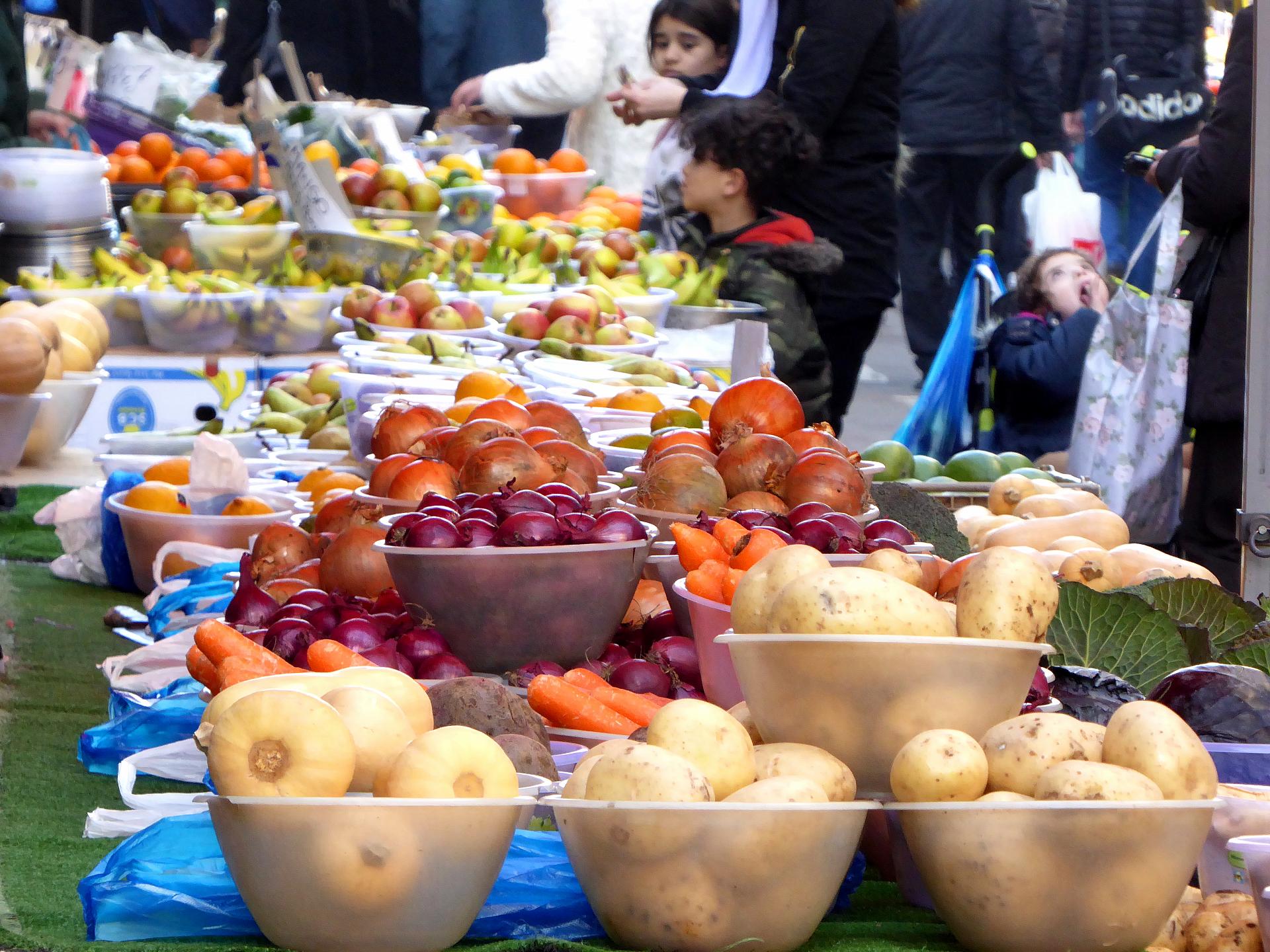

 Atmospheric railways used trackside air pressure to drive the trains. An atmospheric line was built from Croydon to Forest Hill, with pump engines at each end. Expensive and unreliable, the line soon closed. The Croydon engine house was dismantled then reassembled here brick-by-brick.
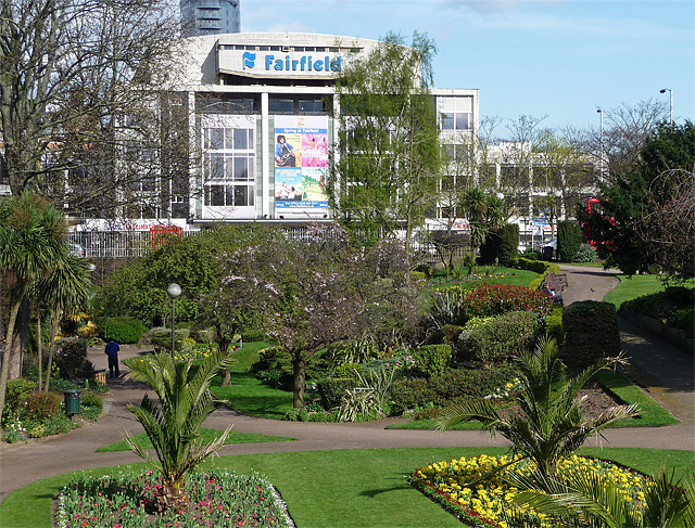
 These stations were far from the town centre though, so in 1868 another one opened on the site of the Town Hall. It was called Croydon Central. The tracks ran through the cutting and passed where the Fairfield Halls are now.
 For several years afterwards much of Croydon needed rebuilding. Given a blank sheet of paper, the town’s planners left signatures that are still visible today.