Welcome to this Discovering Britain walk along the North Norfolk coast from Sheringham. Today we willl be journeying back in time to see how this landscape has been shaped by an extreme Ice Age which covered Britain in a huge sheet of ice.
Technically speaking we are experiencing an Ice Age now as there are parts of the Earth covered by glaciers, but we’re in a relatively warm phase.
Imagine yourself here during one of the cold glacial phases... (click on the picture to enlarge it)
The landscape is mysterious and frightening. Instead of the muddy waters of the North Sea, there is a great ice sheet, hundreds of metres thick, which from time to time creeps southwards into Norfolk. Beyond the ice front you shiver on the chill, barren, dusty plains, sparsely covered by scrubby shrubs, and crossed by streams that during the brief summer melt season become cobble-laden torrents of icy water. Keep this image in mind as you enjoy this spectacular coastline.
This walk was suggested by Daniel Evans, a former Gap Year Scholar from the Royal Geographical Society.
Daniel: “I was born and bred in Norfolk and this area remains very close to my heart. I wanted to demonstrate the diversity of this landscape, so the route includes coastline, farmland, heathland and woodland. I hope you enjoy the walk!”
Pictures:
A Victorian postcard of Sheringham Wikimedia Commons (CCL)
From the bridge go down the steps and continue past a model boating pond on the left. As the concrete promenade shortly turns into a gravel path, stop at the wooden sign to Weybourne on your right. Look down at the shoreline.
2 Back to the Cretaceous
As we edge further away from Sheringham town, let us travel back in time. Our story begins 132 million years ago during the Cretaceous Period.
The word ‘Cretaceous’ stems from the Latin ‘creta’ for chalk and it’s chalk that is particularly evident along this stretch of the coast.
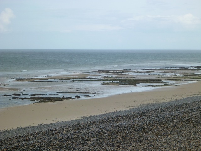
As well as sweeping panoramas, the cliff top here provides wonderful views of the beach below. At low tide, see if you can spot a band of rocks on the foreshore. It’s marked on the OS map as Robin Friend. This shoal of chalk, exposed during Spring tides, is evidence of a time when the climate was very different.
During the Cretaceous Period a warm shallow sea covered the North Norfolk coast. The remains of marine organisms that once lived in this sea turned to calcium carbonate, and have created this chalk platform along the shoreline. The chalk platform has been eroded by the waves. It may not look spectacular but it’s an important (and rare) coastal feature. The chalk shoals are important for rock-dwelling plants and animals including mussels, sea anemone, hermit crabs and starfish.
Continue along the track with the sea on your right. The track runs alongside the perimeter of the golf course. As this path steadily bears right, look out for an elevated flat platform of turf on your left and a sign reading: ‘Number 4 Skelding Hill’; stop here.
3 "Very flat, Norfolk"
Let’s turn round now to look back where we’ve just come from. You will notice Sheringham sits between two cliff peaks - Skelding Hill where we are now and Beeston Bump beyond, one of the highest points in Norfolk.
Turning back towards the coastal path, you’ll appreciate that contrary to Noel Coward’s oft-quoted remark, this area is far from flat. These undulations tell an important story of one of the most landscape-sculpting events in Britain’s history.
At our previous stop, we heard about how the chalk was formed from marine organisms when a warm shallow sea submerged this area. But the climate has not always been warm; indeed Britain has experienced fluctuating cold (glacial) and warm (interglacial) periods over the course of its history. Currently we are experiencing a warm, interglacial period.
The North Norfolk Coastline particularly owes its shape to one of the icy periods, known as the Anglian Glaciation. This was a severe cold period around 500,000 years ago, when a large glacier spread south, covering most of Britain in ice up to three miles thick. This ice sheet covered the area we’re in now and even diverted the River Thames several miles south from its original course to its current position.
Upon warming, the ice retreated and the material it was carrying (called till) was left behind. These deposits, dumped by the glacier, are the hills and bumps that we can see along this stretch of coast. Recently, researchers have discovered that this melting was not a simple process, but happened in a series of stages, leaving the coastline with its distinctly undulating shape.
Continue up a relatively steep hill until you arrive at the Coastguard hut. Take a seat at one of the many benches up here.
4 Ice Age margin
Take a seat and enjoy the view. Looking in one direction we see a patchwork quilt of farmland and woodland, with the pretty heritage steam train snaking through the view. In the opposite direction the jagged coastline of North Norfolk stretches away towards Blakeney and Holkham.
In the middle distance is Sheringham golf course. Those who tee off here may be unaware of the area’s glacial past, but all the same, profit from the slopes and mounds that make their course more exciting.
Skelding Hill is something of an anomaly in the otherwise flat county of Norfolk. Here we are about 170 metres above sea level. At the last stop we learned about an ice sheet that stretched across most of Britain. This hill is a ridge or moraine left behind when the ice melted.
Like many Ice Age features it’s difficult to know exactly how this ridge formed and it may be the result of several glacial phases. All the various bumps and lumps you can see across the golf course are formed from material dumped by the glacier as it retreated.
Descend Skelding Hill and continue along the coastal path. Further on, a series of wooden posts separate this path from the golf course. Count 8 wooden posts and stop to look at the exposed cliff face.
5 Ice Age detective
This section of the walk gives us an opportunity to study the rocks that make up this coastline in some detail. Recent storms have gnawed away at the cliffs here. In doing so, they have exposed some of the sediment that was first brought to Norfolk from Northern Britain some 500,000 years ago during the Anglian Glaciation.
As destructive as coastal erosion is, it does allow us a closer inspection of the material that was transported by that glacier. There are many ways we can tell that this sediment is predominantly of glacial origin and a couple of them are evident here.
If you stand back and take a look at the exposed cliff face as a whole, you will see a range of different size particles, from fine clay and silt, through to small pebbles and cobbles and finally various sized boulders. This wide range of sediment size is referred to as a ‘diamicton’ and is normally evidence of glacial activity.
Essentially, the power of a glacier is such that it picks up and transports material of all different sizes, unlike a river that hasn’t got the energy to pick up and transport large boulders.
Also notice that the different size particles haven’t been sorted out into obvious layers. Unlike river sediments, which normally deposit in distinct layers, when glaciers melt large and small sediments are jumbled together. This unsorted material offers us yet more clues to how this landscape has been powerfully shaped by ice.
Continue along the coastal path to the very end of the golf course. Stop at a white National Trust sign on your left introducing Sheringham Park.
6 Butterflies and bees
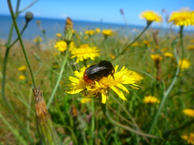
As you descended Skelding Hill, hopefully you noticed an increase in the variety and number of plants and animal species. In summer these fields are buzzing with the noise of bees and insects enjoying the wildflowers and plants that flourish here. This entire cliff-top is an Area of Outstanding Natural Beauty (AONB) but this particular stretch of coastline called the Old Hithe is particularly precious; so much so, that it has been awarded SSSI status.
Many people take the exciting diversity of organisms here for granted, and few consider why these particular species make this their home. It’s partly down to the soil that influences which plants are able to grow here. Not only do plants and animals have to adapt to a wind-swept environment, but the soil also has to be of certain standard so that species can thrive.
The soil is composed of material transported here during the Anglian Glaciation. These acidic, sandy soils are ideal conditions for plants including the yellow flowered Hop Trefoil and the distinctive Sea Pink with its lollipops of pink flowers which flourishes in dry, sandy soils.
As well as birds like the skylark, the Old Hithe is also home to a butterfly that visits our shores after a long journey. The colourful orange and black Painted Lady flies all the way from North Africa, the Middle East and Central Asia to arrive in Eastern England in summer.
Continue along this path, passing a red arrow marker on your left. Soon, this path will divide into two; take the path to the right and continue following the route along the cliff-top. Eventually, you will approach a T-junction. Turn left onto a narrow path leading up towards a cluster of trees in the distance. Stop on the railway bridge and look over to the right of the train tracks to spot a hollow of trees in the field.
7 Sleepy hollow
In the field to the right of the train track, shrouded by small trees and shrubs, is a small steep-sided hollow. The truth as to how it was formed is still unknown but it may be more evidence of how ice has left its mark on the landscape.
One theory is that the hollows here were dug out by humans to collect water. Another theory is that it was dug for mining operations. The sediments that overlie this area are rich in minerals - such as kaolinite, illite and quartz - and a hollow would have allowed for an easier access to them.
Another possibility is that these hollows were shaped from depressions that were already evident in the landscape.
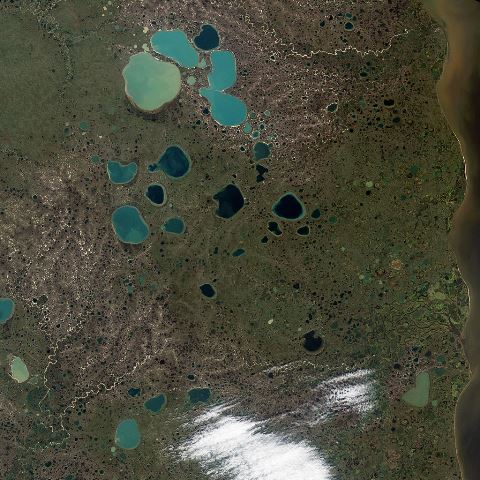
As the Anglian Glaciation retreated large blocks of ice were left behind. When these eventually melted, they left depressions in the ground known as kettle holes. Humans might then have later taken advantage of these hollows as a place to store water.
Picture:
NASA photo of glacial lakes (kettle holes) in Siberia Wikimedia Commons (CCL)
Directions
Continue over the bridge and along the track towards a large wooden gate. Rather than going through this, bear right down the side of a field, keeping parallel to the road on your left. At the end of this track, carefully cross the road and go through a small wooden gate to enter Sheringham Park. Follow the path alongside a couple of arable fields, pass a redbrick lookout then stop at a bench on your left, with some steps behind it. There are 131 steps to reach the gazebo viewing tower. If you can, climb the steps to overlook the park.
8 Room with a view
Your reward for climbing all those steps is a bird’s eye view of the landscape. Enjoy this rare chance to be up above the canopy of the trees.
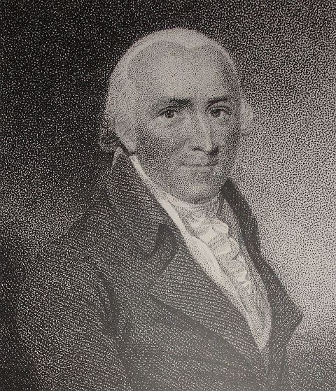
Here, nestled amongst the treetops, we can really appreciate the surrounding landscape, including the magnificent Sheringham Park. The gardens were landscaped by Humphrey Repton who dominated English garden design in the nineteenth century.
If you look carefully you can see that the park has been subtly and sympathetically landscaped. Although the surface texture of the parkland is relatively young, dating back just two hundred years, deep at the heart of this area is a story many hundreds of thousands years old.
Earlier, we walked along the edge of the Sheringham cliff top and discovered that this part of Norfolk is far from flat. It was here we found out that the hilly, undulating landscape was formed by the Anglian Glaciation. This was the ice sheet which covered much of Britain, and on retreat left behind material which created the hummocky, uneven bumps and hollows we can still see today. The gazebo marks the edge of this material.
When we descend the gazebo you’ll notice that most of the landscape around us is flat except for several wooded hills, including this one that the gazebo was built on. These hills were the nodes of the glacier. Like a splayed hands, these bumps are the very ends of its ‘fingers’.
You can also see that Sheringham Park is not completely flat but sits in a range of shallow hills. When the ice sheet melted, the meltwater carved out river valleys which have become the gentle dips and hills of the parkland today.
Descend the gazebo back to the bench and turn left to continue along the path through the park. At the wooden gate signposted to Weybourne station, veer right and stop at the bench on the left below the wood.
9 Parkscape
500,000 years ago the landscape was shaped by a huge sheet of ice, but fast forward to 1811 and it was garden designer Humphry Repton who continued to model it. Unlike many architects, Repton did not believe in re-siting or re-routing features. Instead he worked with the natural landscape. When he designed Sheringham Park his understanding of the geography of the area was the key to his success.
Woodlands were planted on the hilltops to stabilise the soil, while the flat land beneath was left for arable farming. Instead of cutting through the natural features, Repton aligned the footpaths to skirt around their perimeter.
From the bench, you may be able to catch a glimpse of the sea through the plantation of tall Scots pine and fir trees in a straight line ahead. Park warden Keith Zealand explains: “Planting these narrow pines allows the visitor to catch sight of the coast between the trunks. I believe Repton was deliberately framing our view of the sea and generating a sense of anticipation in the viewer.”
Just like the make-up of the park itself, from broad-leaved plantations to arable farmland, the parkscape is a mosaic of time periods. Some aspects haven’t changed for millennia; other features such as the gazebo at the last stop are less than 30 years old. They all work together to create this special place we are enjoying today.
Pictures:
Portrait of Humphry Repton / Repton’s business card showed him at work landscaping a large estate garden (click on the pcture to enlarge) Wikimedia Commons (CCL)
Directions
Continue along the path towards woodland, and eventually through a gate with a sign for Weybourne Heath. Pass a bench on your right and continue through the woods until the path divides into two. Take the path to your right, and follow the track alongside the heathland, until you see a wooden bench on your left overlooking arable fields; stop here.
10 Sensing the heath
From the exquisite Sheringham Park, we come to Weybourne Heath. Today both are owned and maintained by the National Trust.
Take a gentle stroll through the heath and immerse yourself within this sensory landscape. Stop, look, listen and breathe in. It’s a quiet, contemplative spot, a contrast to the gusty, weathered cliff top we were rambling upon earlier.
Weybourne Heath is a place to exercise your senses. Listen to the calls of the song thrush or the chirring of the nightjar, both of which are in serious decline and are protected species. Hear the scratchy song of the whitethroat or the drumming of the great-spotted woodpecker.
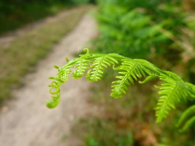
Enjoy the lemony aroma offered by the five-petalled flowers of the Trailing St John’s Wort or the honey-scented flowers from the white flowering Ling heather. Nestled in and around these exotic species is the familiar earthy smell of bracken, the most common fern on the heath.
Up behind us on the hill a range of Scots pines stand sentinel. Their bright green needles create a strong contrast with the yellow-brown bracken. Stop and pick up the pinecones; feel how different their texture is to the bracken’s dense yet delicate thickets.
Walk along an obvious path alongside a steep hill to your left and an arable field to your right. Continue down some steps towards Weybourne station. If the gate is open, make your way to the platform and cross the bridge. Follow the signs towards the exit, cut through the car park, and walk along the road ahead into Weybourne village. (If the platform gate is locked, continue up to Sandy Hill Road and walk across the bridge.)
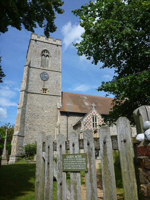
When you get to the village, continue along the road until you reach a T-junction. Turn right down Church Street to stop at the entrance of the church.
11 Meet the flintstones
Set before a backdrop of rolling farmland, Weybourne is a quintessential Norfolk village, where time seems to stand still. Being part of an armed camp during the Armada and both World Wars, it certainly has a rich history, although if you look carefully, Weybourne hosts a much older story; one that has been millions of years in the making.
From the gate leading to the church, take a closer look at the church and the cottages that make up the village. It’s hard to ignore the distinctive dark grey, green and white flint which is used as a building material all over the village.
The flint you can see in the buildings here was also used by Neolithic people to create tools and hunting implements. It was probably picked directly from the coast.
During the Cretaceous Period, 62-132 million years ago, this area was submerged under a warm, shallow sea, and was the habitat for microscopic marine organisms. Their remains can still be found to this day along the base of Weybourne’s cliffs.
As sea sponges and micro-organisms decayed on the sea bed, silica collected around them. Throughout time, it hardened to form flint. These bands of flint are in concentrated pores of chalk. Being easily erodible, the chalk has released the flint over the centuries and it has accumulated along the beach. When the church and other village buildings were constructed people would have used whatever local material was to hand, namely flint.
Walk through the graveyard towards the church porch and then left to exit. Pass the bus shelter on your right and The Ship Inn on your left, before turning right down Beach Lane. Continue down this road, walk through the beach car park towards the shore and scramble up a steep shingle bank. Stop here.
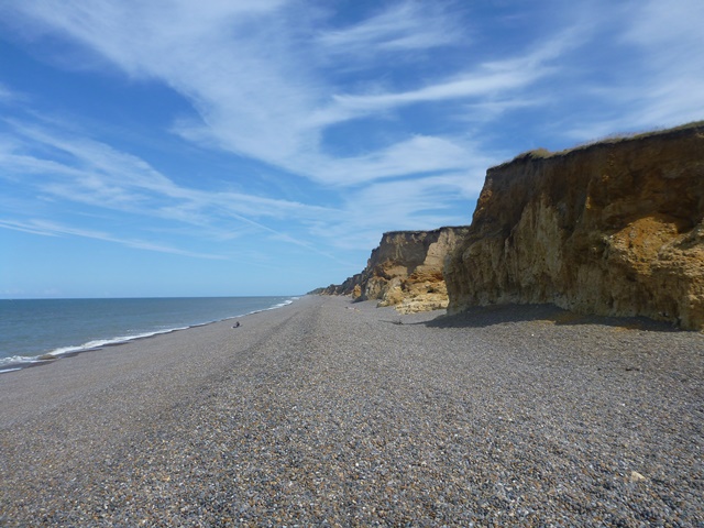
12 Where two views meet
As we return to the coast, this time we’re walking along a low level shingle beach rather than the breezy cliff top. Here two very different views and two different geographical narratives greet us in either direction.
Facing the sea, look to the right. The coastal landscape reflects the story we’ve already told in this walk so far. A vertical cliff of about 20 metres, composed of material transported here by the Anglian Glaciation, stands foreboding over a steep gravel beach. The end of this walk will take us past these cliffs so we can take a closer look.
Now turn the other way, bearing west towards The Wash. The ominous cliff is substituted with the less threatening shingle beach and a ridge of low cliffs. As you might remember from earlier, the ice sheet did not cover the entire Norfolk coastline but stopped at the gazebo in Sheringham Park.
When the ice sheet melted, the area before it was flooded with meltwater which deposited fine sandy, gravelly sediments. The landscape to the left is characteristic of these outwash The west view of the flat outwash plain plains which are generally flat.
Facing the sea, turn right to walk towards Sheringham along the beach. Walk about 200 metres and stop at a series of small caves that appear at the base of the cliffs.
13 Layers and swirls
Walk along the cliff face and the pieces of the story we have told throughout this walk now start to join together. From here on the beach, you can clearly see the distinct layers in the cliff, composed of material from different periods of time, and under a range of climatic conditions.
Imagine a pile of newspapers, the oldest at the bottom of the pile, the newest on top. This is how we can read the age of the rocks in the cliff face. Beginning at the bottom with the chalk.
Here at Weybourne you can properly appreciate the white chalk we have often mentioned in the course of this walk, which was formed during the Cretaceous Period 132 million years ago. As we walk further east back towards Sheringham, that chalk disappears underneath your feet. It is only exposed at low tide, as the chalk platform known as Robin Friend that we saw earlier.
Directly overlying this chalk is a thin layer of grey shelly sands, called the Weybourne Crag. These were deposited about 2 million years ago, and are cemented together by a layer of iron, giving the deposit a reddish colour. As rainwater has percolated through the cliff, it has displaced some of the iron and transported it to the chalk below.
Study this cliff section carefully, and it is possible to make out the individual ingredients that make up this layer. The grey shelly sands and clays in the Weybourne Crag layer were deposited when a warm shallow sea covered the North Norfolk coast. Larger particles include flints, pebbles and shells.
Although scientists argue over the exact time, it is widely believed that these were all deposited during a complicated sequence of climatic events immediately before the Anglian Glaciation.
Overlying these sediments and composing the majority of the cliff you see above are the dark grey clay deposits left during the Anglian Glaciation. It is interesting to notice that in certain places, particularly around Weybourne, the layers of material are no longer flat, but have deformed to create curves and swirls in the cliff.
Originally they would have been laid down in relatively flat layers; however as the ice sheet loaded on top of these deposits, its weight caused these layers to contort. When the ice eventually melted, this once again altered the pressure exerted onto these sediments and deformation occurred again. Meltwater beneath the glacier would have also percolated through these beds of sediment and modified them even more.
Walk about 10 metres to explore more of the caves along this stretch of coastline. Stop at the next cave you see; it won’t be too far away.
14 Green caves
It’s fun to walk into the caves and see them up close, but just why have they formed here?
The soft glacial material that makes up these cliffs makes them particularly vulnerable to erosion, and there are some notable examples of where recent storms have pounded the coastline.
But these cliffs are attacked from both below and above. As well as wave action, the cliffs are also weakened by rainwater. This saturates the impermeable layers of clay at the top, making the clay much heavier and prone to crumble.
Not far from Weybourne, the Cretaceous chalk that sits at the base of the coastline has also suffered from wave-induced erosion. Study the area closely and you will see small cavities opening up where the waves have pummelled the cliffs. Larger caves can also be seen, formed from many months of steady erosion.
In some caves, you may also spot a mound of pebbles that look identical to the ones you are walking on. High energy waves have hurled these pebbles from the beach into the caves, the impact of which would have further weakened the cave walls.
If you’re able to get close enough to inspect the back of the caves, you may spot a green pigment. What you are actually seeing are coccolithophores; an algae that is often associated with chalk. 100 million years ago, coccolithophores lived in the upper waters of the warm shallow sea that submerged most of the surrounding area.
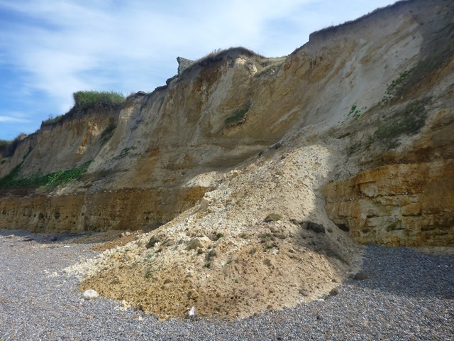
Walk for some distance along the beach. Look out for fan-shaped deposits of materials which have slid down from the cliff on to the beach. Stop when you see them.
15 Landslide!
At the last stop, we spent time studying the undercutting along the base of the cliffs, near Weybourne. Further along here, there is evidence of other forms of erosion that shape the landscape we see today.
The glacial clays that make up the upper section of these cliffs are impermeable, which means water cannot pass through them. Over time, the rainwater builds up above the clay and has nowhere to go. Excessive volumes of water can lead to saturation and the pressure exerted on the clays can cause mudflows and mudslides such as these.
Compared to the cave formations we saw at the previous stop, these ‘slides’ are rapid forms of erosion and occur without warning, disturbing plant and animal communities within the cliff face and causing disruption for those who use this stretch of beach.
Material moves quickly down the cliff face due to gravity and it accumulates in a fan-shaped feature called a scree. You may notice that many screes along this coastline include large boulders of chalk. Unlike the chalk at the base of cliffs near Weybourne, these pieces were plucked from the bedrock of northern England and Scandinavia.
These pieces of chalk were transported here by the Anglian ice sheet and are good examples of ‘erratics’. This is the name given to rocks believed to have been carried great distances by glacial action.
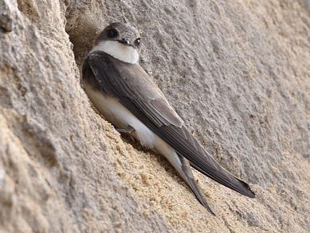
Continue along the beach. When the cliffs are at their lowest point and it is possible to step off the beach and back onto the coastal path, walk just past this point and look up to find a series of circular holes in the cliff face.
16 Holes and homes
If you peer up to the cliff-top, you will be able to spot a group of holes. In fact, these are the start of metre-long tunnels that Sand Martins bore to breed in. Although weak and very vulnerable to erosion, the sandy cliff makes an excellent home for Sand martins, who are common summer visitors along this coastline between March and October.
Over the past 50 years, the population of these birds has decreased substantially as a result of drought in their wintering grounds in Africa. Therefore, protecting the cliffs here at Weybourne from erosion is especially critical. The Norfolk Biodiversity Action Plan and the RSPB are currently working to protect these Sand martin habitats.
Unfortunately, the cliffs are also weakened by another coastal process. The cliffs are undercut - eroded at the base - by the waves. So the integrity of some of the Sand martin cliff-top habitats are doubly threatened.
Step off the beach and up to the coastal path. Walk back up and over Skelding Hill and towards Sheringham town centre. Stop past The Lees gardens when you reach a road called the Promenade.
17 Carved by water
Though we are now near the end of our route, the story of this landscape is constantly evolving.
During the walk, we have explored how global climate changes have left distinctive marks upon a local landscape.
We may have left our footprints on the path today but the landscape has been shaped by far more powerful forces than us.
Over millions of years this coastline has been catapulted through climates and environments and sculpted by events that are almost impossible to imagine in our relatively warm climate today.
We discovered that Sheringham was at the edge of a great ice sheet which covered most of Britain and have learnt how this literally carved out the scenically rich landscape of North Norfolk, disproving the myth that Norfolk is flat.
We have found out about a nineteenth century landscape designer whose understanding of geography helped him work with rather than against the natural topography, and learned too how modern day processes of coastal erosion are continually re-shaping this landscape as it comes under attack from the forces of the sea.
Indeed water is the key to this landscape. From being submerged under a warm, tropical sea to covered by a huge sheet of ice; from the meltwater that the glacier left behind to carve out valleys to the rain that falls and erodes the cliff; from waves and storms that pummel the coastline to bays and beaches which attract holidaymakers and provide a livelihood to fishermen - this is a landscape shaped by water.
We hope you have enjoyed this walk along the North Norfolk coast and feel inspired to discover more of Britain’s rich geography.
From the Promenade you can easily return to Sheringham beach or explore the town centre and visit the musuems. Turn right at the end of the Promenade to join Sheringham High Street. You can continue onto Station Road and Railway Approach to visit the tourist information centre and the Poppy Line steam railway.
Your browser is out of date, and unsupported by this website. Please upgrade to the latest version to use this website.

.jpg "Ice Age landscape © Mauricio Antón, Wikimedia Commons (CCL)")
.jpg)
 including the North Norfolk Railway Steam Train.jpg)


.jpg)
 (5).jpg)

.jpg)
