We begin walking around Norwich at one of the traditional markers of being a city - having a cathedral. This is the largest building in East Anglia. Begun in 1096 it’s also one of the oldest and gives us an insight into Norwich’s origins.
People have lived in this part of Norfolk for at least 5,000 years. In 60 AD there was a Roman town at nearby Caistor St Edmund. Norwich itself emerged 700 years later from a Saxon settlement called ‘Norvic’. By the tenth century Norvic was a large market town of around 6,000 people.
The city we can see today developed after the Norman invasion of 1066. The Normans built the Cathedral and nearby Norwich Castle. Made in specially-imported French limestone, both buildings were symbols of Norman supremacy.
The cathedral is symbolic in other ways. Look up at the tower and spire. Church spires represent holiness by literally reaching towards heaven. Norwich Cathedral pierces the air to 96 metres (315 feet). Only Salisbury Cathedral is taller (at 123 metres / 404 feet).
It’s tempting to think that Norwich has the second-tallest cathedral because it was England’s second-largest city. There is still a widespread belief that cathedrals give a place city status. Norwich, like Liverpool, even has two cathedrals.
There are several cities without a cathedral though - and around a dozen cathedrals that are not in a city. So what’s the connection?
Historically, towns were considered cities if they had a ‘diocesan’ cathedral. Dioceses are the Church’s administrative regions. Cathedral cities became official in the 1540s, when King Henry VIII reorganised the Church during the Reformation. Henry created six new dioceses and awarded their cathedral towns with city status.
By that time, Norwich had been a city for over 140 years. The capital of East Anglia was wealthy and influential, with widespread trade links. Let’s trace the sources of its success.
Engraving of Norwich Cathedral in 1879, Wikimedia Commons (CCL)
Directions
Keep the Cathedral on your left and walk towards the other statue on the lawn (the Duke of Wellington). Pass this statue then turn left to join a road sloping gently downhill. With the Cathedral still on your left, pass the Chapter Office and follow the road ahead. Take care for traffic along the way. After a set of playing fields, stop in front of a stone building with a wide arch in it.
2 Pull's Ferry
This curious house is called Pull’s Ferry. Look through the arch and we can see why. This spot marks a historic crossing point over the River Wensum beyond. An information board beside the road outlines the building’s story.
Did you notice how straight the road to Pull’s Ferry was? We’ve walked the route of an old canal. The Normans cut it while building the Cathedral, to carry the limestone as far as possible.
The stone arrived here by boat all the way from Caen in northern France. But how, when Norwich is 20 miles inland? To find out, go through the arch of Pull’s Ferry and look at the river.
For centuries, Norwich was largely isolated from the rest of England by the Norfolk Broads, a vast expanse of marshy fenland veined with rivers and streams. Before railways developed, Norwich was often easier to reach by boat from Amsterdam than by road from London!
The River Wensum became the main route into Norwich. The Wensum emerges 25 miles northwest of here between three small villages. Three miles after sweeping around the east of Norwich, it joins another river - the Yare. The Yare flows east though the Broads for 35 miles then enters the North Sea at Great Yarmouth.
From Great Yarmouth, boats could navigate by tidal river all the way into Norwich. Direct access to the sea allowed Norwich to trade goods with Europe, especially the Low Countries (today’s Netherlands, Belgium and Denmark). European trade made Norwich immensely wealthy and still shapes the city’s character. Later, we’ll explore how.
For now, notice how quiet the Wensum is. Small pleasure boats waft along its gentle meanders, while walkers and cyclists enjoy the paths. It seems unlikely that this willow-lined waterway used to be a busy working river. But a clue remains in Norwich’s name. ‘Norvic’ was Saxon for ‘north port’.
Go back through the arch. With Pull’s Ferry behind you, turn right and follow the path through a gate. Continue along the path with the river on your right. The path sometimes leaves the riverside and there are a few more gates to go through. These are left open in daylight hours.
When you reach a stone bridge (Bishop’s Bridge), continue ahead towards The Red Lion pub. Keep the pub on your right and follow the path past the car park. The path becomes lined with trees then curves left. Stop when you reach a brick tower beside the river.
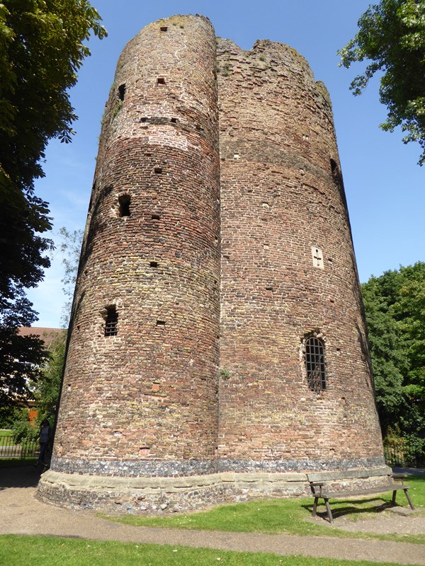
3 The Cow Tower
The River Wensum opened Norwich up to trade but also threats from less friendly visitors. In the 820s eastern England was raided - and ruled - several times by Danish Vikings. A visit from “King Sweyn Forkbeard” in 1004 left Norwich “completely burned and ravaged”.
As Norwich became increasingly important in the Middle Ages, defences were built to stop another sacking. This is the Cow Tower, a former tollbooth that was converted for military use. Originally built in the 1240s it’s one of the oldest defence towers in the country.
Notice we are by a sharp bend in the river. This strategic site allowed soldiers inside the tower to spot potential enemies from a greater distance. Peer through the slit windows. These concealed hand-held weapons like crossbows and guns.
The Wensum only protected part of Norwich though. After the Normans arrived Norwich had expanded west, away from the river. To protect the rest of the town, a huge flint wall was built around it. The work began in 1294 and took about 40 years to complete.
The wall was 2½ miles long and used enough stone to build 80 churches. When it was finished, Norwich became the biggest walled town in England, with a greater land area than London. To boost the wall’s integrity, a law banned any new buildings outside of it.
As Norwich’s status increased, so did the population. More people moved in from the surrounding countryside, especially for work. Norwich became increasingly crowded. The city centre is still packed with a dense medieval labyrinth of narrow lanes and alleys.
Today only small sections of the wall remain. From the 1790s it was gradually dismantled so the city could expand. The Cow Tower is now a rare survivor of Norwich’s historic defences. We’ll soon discover what made Norwich so attractive and worth protecting.
Continue following the path with the river on your right. Pass a modern curving bridge (Jarrolds Bridge) where shortly afterwards the river bends to the left. Look across the river here for the remains of another defence tower.
A little further, you’ll be opposite a large redbrick building by a line of willow trees. Continue along the path and take the steps or ramp onto a stone bridge. Stop halfway across it and look back at the large building.
4 St James Mill
Besides connecting and protecting Norwich, the Wensum fuelled many types of work. Brewing, printing, and shoemaking all relied on a constant supply of water. The river’s major use though was making textiles. Across the river is a legacy of this industry, St James Mill.
From the fourteenth to eighteenth centuries Norwich was at the centre of British wool making. The city became famous for ‘worsted’ woollen cloth. Wool was washed in the Wensum and woven on looms into a fine yarn. It was then softened with local clay to make it more wearable.
Clay soils are ‘impermeable’, which means they retain water. Norfolk’s mostly flat clay fields provided lush sheep and cattle pasture. As a result, a series of county-wide roads spread for moving livestock. Several of these ‘drovers roads’ passed through Norwich, which helped the town develop a textiles trade.
Visiting Norwich in 1698 traveller Celia Fiennes found “a rich, thriving industrious place full of weaving, knitting and dyeing”. Norwich textiles peaked in the 1720s when the city had 12,000 looms and around 70,000 people were employed in wool work.
Built a century later, St James Mill is an industry landmark. But does it seem out of place? Large industrial buildings like this are rare in East Anglia.
When the mill opened in 1839, Norwich’s ‘woolly mammoth’ faced extinction. From the 1790s the Napoleonic Wars reduced the city’s textiles trade with Europe. Another threat was the North West of England’s new industrial mill towns.
The North West’s Atlantic-facing ports were ideally located to trade with America. American cotton soon superseded home-spun wool. The North West also got lots of rain, swept in from the Atlantic and drained off the Pennines. This climate gave the region’s industrial mills a constant power supply.
Norwich meanwhile is much drier, with below-average rainfall levels. But water wasn’t the only shortage. Early industries relied upon coal. Coal powered everything, from furnaces and steam engines to household kitchens. While areas like the North West had rich natural coal seams, Norfolk had none.
St James Mill was an impressive attempt to sustain Norwich’s textile trade. The city had been overtaken though and lost its monopoly. In 1901 St James Mill became a chocolate factory and is now used for offices. Looming over the river (in more ways than one), it reflects how England’s second-largest city unravelled.
With the Mill behind you, turn left. Continue to the end of the bridge then cross the road - take care as traffic moves quickly here. Re-join the riverside path with the Wensum on your right. Follow the path up to the next bridge (Fye Bridge). Go onto the bridge and stop in the middle.
5 The Quayside, Fye Bridge
Pause here and look back along the river. Below us is the Quayside. A row of colourful houses line the water, while the Cathedral spire beyond completes a picture-postcard scene.
The river here used to be crammed with barges. Imagine the banks packed with workers and horses, carts and trucks, piles of goods stacked on the cobbles...
The Quayside was where boats loaded and unloaded their cargo on the way to or from the North Sea. Norwich’s main export was wool. Imports included Chinese tea, American tobacco, and rum and sugar from the West Indies. Other arrivals included Newcastle coal and fish from the Norfolk coast.
Another import is still visible today. Look carefully at the house roofs. Many have curved red ‘pantiles’. Pantiles are a common sight in eastern England but originate from the Netherlands. They arrived here as ballast in Dutch ships, which stocked up with English wool then left the tiles behind.
Did you also spot the bale-shaped sculptures lining the Quayside wall? They feature the names of people and companies that worked here in the last 200 years. The Quayside was busy until the Wensum lost its commercial traffic to railways and large coastal ports.
Also notice this bridge. The current Fye Bridge dates from the 1930s but there was one here at least 800 years earlier. The name highlights that Norwich had at least ‘fye’ (five) bridges over the Wensum by the 1300s. That’s more bridges than London had over the Thames.
By contrast, there were no bridges at all between Norwich and Great Yarmouth. Norwich’s low-lying location was the first suitable river crossing from the sea. The city’s historic bridges are not just signs of prestige. They are also a reminder of why people first settled here.
With your back to the Quayside, carefully cross the road and turn left to the end of Fye Bridge. Just before a church, turn right into the bottom of Elm Hill. As you go up Elm Hill, take your time to browse the street - though watch your footing on the cobbles! Stop towards the top of the hill by the large tree on the left. There is a bench around the trunk where you can have a rest.
6 The Britons Arms, Elm Hill
Elm Hill is Norwich’s most famous street. From up here near the top we can see why. The cobbled road lined with tumbling timber-framed buildings is very pretty. This street also offers us a glimpse of what England’s ‘second city’ would have looked like.
But there is more to the scenery than meets the eye.
First, look downhill at the left side of the street. It isn’t obvious but these buildings back onto the Wensum. Residents included merchants and traders. While their houses faced the street, behind were workshops and stores. Many had quays directly onto the river.
Elm Hill was a major road between the river and town centre. Remember the goods we heard about at the Quayside? Many were carried in or out of Norwich along this street. This scenic spot was a bustling working thoroughfare.
The earliest accounts of Elm Hill are from around 1200. Almost everything we can see though is Tudor or later. In 1507 Norwich suffered a terrible fire. Hundreds of wooden and thatched buildings were destroyed, including here on Elm Hill. Looking uphill, The Britons Arms (on the left beyond the bench) was one of the few survivors.
Other disasters followed. The street was named after a group of elms that were planted nearby. In the 1970s they were killed by Dutch Elm Disease and replaced with plane trees. Fifty years earlier, the street itself had barely survived. As the Wensum’s trade declined, so did parts of Norwich’s riverside. By the 1920s Elm Hill was a slum and earmarked for demolition.
Saved by campaigners, the street has come full circle in Norwich’s economy. Today Elm Hill is in high demand for television, film, and photography shoots. The street’s changing fortunes reflect those of a city where heritage has become a major asset.
Norwich is marketed as the ‘City of Stories’. At the next stop we’ll meet some major characters.
Continue up Elm Hill as it bears left around The Britons Arms. At the top turn sharp right and follow the road downhill towards The Halls. Turn your back on The Halls and use the zebra crossing outside of them to go ahead into St Andrews Hill.
Take the first right and pass by the church. Then turn left and pass the entrance to the Museum of Norwich at the Bridewell. At the next junction turn right and continue along cobbled Bedford Street. Pass the Jarrolds store on the left and carefully cross over Exchange Street to enter Lobster Lane.
When you reach another church on the right (St John, Maddermarket) turn right and follow the alley underneath the tower. Pass the Maddermarket Theatre then turn left at the end. After a short distance, stop outside The Strangers’ Hall Museum.
7 The Strangers’ Hall
We are now in the oldest area of the city, the Norwich Lanes. The narrow winding streets here follow a medieval layout. Nestled among them is The Strangers’ Hall. Now a museum, it was originally a house owned by a series of important merchants.
This building is full of clues to the people who shaped the city. First is the name. The ‘Strangers’ were migrants from the Low Countries who settled in Norwich to escape religious oppression.
In sixteenth century Europe, Protestants became persecuted for their beliefs. Many left their homelands for asylum elsewhere. Norwich’s location and established European trade links were especially attractive.
The city’s authorities also realised that new people could bring new skills. In 1565 they invited a group of Protestants from the Netherlands to live here. Soon a third of Norwich’s population were Dutch, Flemish, Belgian Walloons and French Huguenots.
The Strangers’ Hall reveals how they made a living. Notice, like other buildings nearby, it has large downstairs windows. These allowed plenty of light inside for weaving on looms. With these new techniques, the Strangers helped to strengthen Norwich’s textiles industry.
Also look for red-painted posts in the lanes. They celebrate Norwich's textiles heritage. By the time the Strangers arrived, Norwich was famous for bright red clothes called 'madder ware'. They were made from the crushed roots of madder plants and sold nearby at a ‘madder market’.
Norwich’s signature colour though is yellow. The city’s famous yellow goods range from mustard to sports cars. It’s fitting that The Strangers’ Hall is painted yellow as it was the Strangers who helped to popularise the colour here.
When the Flemish and Walloon weavers arrived, some brought their pet canaries with them for company at their looms. Canaries originate from the Canary Islands off northwest Africa, including Tenerife and Lanzarote. Explorers then took them into Europe.
Thanks to the Strangers, canary breeding became another Norwich industry. These exotic birds are celebrated today by Norwich City football club, who play in yellow kit and are nicknamed ‘the Canaries’.
With the Strangers’ Hall on your left continue to a set of red posts. Turn left and go into the uphill lane past St Gregory’s church. Leave the churchyard by taking the diagonal path to the left with a boat-shaped artwork set in the ground.
Bear left past The Strangers Coffee House and continue into Lower Goat Lane, another narrow uphill street. At the top you will emerge opposite the City Hall clock tower. Turn left again and head towards the Guildhall, the smaller dark building that looks a bit like another church. Stop by the series of bicycle racks facing the Guildhall’s chequered end wall.
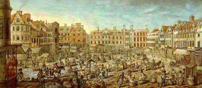
8 Norwich Guildhall and Market Place
We finish at Norwich’s commercial heart, the market place. Founded in the 1070s, Norwich Market is thought to be the oldest in England. Its sea of striped roofs is another legacy of the Normans. Look on the left horizon for their Castle, keeping watch over the stalls below.
Other buildings surrounding the Market offer a potted history of Norwich. Straight ahead is its finest medieval church, St Peter Mancroft, while to our right is the 1930s City Hall. Literally overshadowed by the City Hall, the building next to us may seem unimportant. But it’s arguably the key one.
This is the Guildhall. Guilds were societies for skilled workers. They were the forerunners of councils and trade unions. When the Guildhall was completed in 1424 there were around 130 recorded trades in Norwich.
This building is England’s largest Guildhall outside London and reflects an important chapter in the ‘City of Stories’. As Norwich grew (in size and wealth) from trading wool, King Henry IV granted the town a ‘charter of incorporation’ in 1404.
The charter made Norwich one of Britain’s first official cities. City status allowed Norwich various freedoms, including collecting taxes, electing a mayor and holding law courts. The Guildhall was built to host and celebrate these new duties.
Notice the chequered end wall. Black and white squares are a traditional symbol of tax collectors. The title Chancellor of the Exchequer stems from Treasury taxes being collected on a chequered table. This wall is therefore decorative and practical, explaining the building’s purpose.
The Guildhall has had other uses over the centuries. Council sessions were held here until the City Hall opened in 1938. Today’s bicycle racks stand where criminals were held in stocks, while the café was once a prison! The Guildhall also stored the city’s horse-drawn fire engine.
Dwarfed by later development but a proud piece of history, it’s tempting to see the Guildhall as Norwich in microcosm. Today it reveals the city’s origins and reflects its current status. Or does it?
It’s ironic that Norwich is sometimes seen as inward and old-fashioned when the city developed through trading overseas. The city also has a proud heritage of innovation, from pedestrianised streets to free city-wide Wi-Fi.
In 2012 Norwich became the UK’s first UNESCO City of Literature. The award reflected how the city had printed England’s first local newspaper, opened England’s first public lending library and was the home of the country's first Creative Writing university degree.
England’s ‘second city’ has long been a home of firsts.
Pictures:
Norwich Market Place by Robert Dighton, 1799, Wikimedia Commons (CCL)
To return to the Cathedral, keep the Market on your right and continue downhill towards the Jarrold building. Bear right and enter London Street. Follow London Street all the way to the end. Most of it is pedestrianised.
At the end bear left and use the traffic lights to continue into Queen Street. This road leads to Tombland, the triangular green beside the cathedral grounds. Continue straight ahead to enter the cathedral by the Ethelbert Gate or turn left along Tombland to reach the Erpingham Gate.
Your browser is out of date, and unsupported by this website. Please upgrade to the latest version to use this website.
England’s biggest city is London but where comes next? Birmingham, Manchester and Liverpool all have strong claims. For over 500 years though the answer was…Norwich.
Today Norwich is often portrayed as a backwater. Without a motorway and within a National Park, it can seem quiet and provincial. Yet from the Middle Ages to the Industrial Revolution, Norwich was a thriving powerhouse famed throughout Europe.
This short walk visits some of Norwich’s most attractive sights to explore why the capital of East Anglia was once England’s ‘second city’.
Follow the trail by clicking on the map pins or downloading the guides below
Some uphill sections and old cobbled roads without pavements
Keep an eye out for:
A local saying claims Norwich has “a pub for every day of the year and a church for every Sunday” – see how many you can spot!
Directions to Stop 1:
Start by entering the Cathedral grounds through either the Erpingham or Ethelbert Gate. You will enter a rectangular lawn called the Close. Look on the lawn for a statue of Lord Nelson near the Cathedral spire. Stop by this statue and look towards the Cathedral.
Norwich trail credits
Thank you to -
Rory Walsh for creating and photographing this trail
Helen Rawling and Caroline Millar for advice on the text
mira66 for archive photos reproduced via Flickr under Creative Commons Licenses
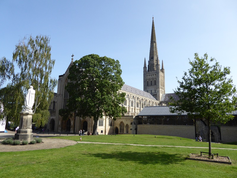
 The cathedral is symbolic in other ways. Look up at the tower and spire. Church spires represent holiness by literally reaching towards heaven. Norwich Cathedral pierces the air to 96 metres (315 feet). Only Salisbury Cathedral is taller (at 123 metres / 404 feet).
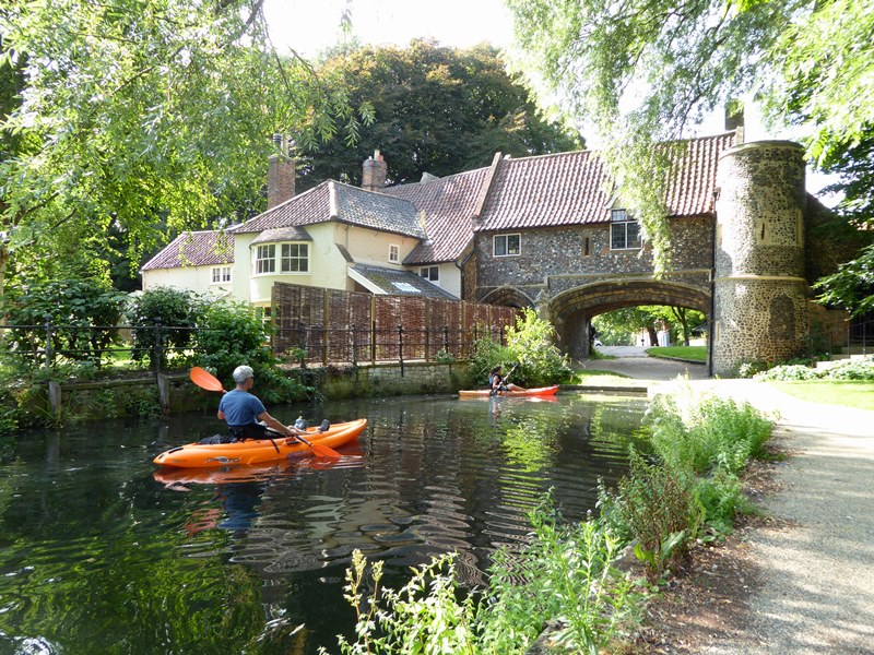

 Also notice this bridge. The current Fye Bridge dates from the 1930s but there was one here at least 800 years earlier. The name highlights that Norwich had at least ‘fye’ (five) bridges over the Wensum by the 1300s. That’s more bridges than London had over the Thames.

 Other disasters followed. The street was named after a group of elms that were planted nearby. In the 1970s they were killed by Dutch Elm Disease and replaced with plane trees. Fifty years earlier, the street itself had barely survived. As the Wensum’s trade declined, so did parts of Norwich’s riverside. By the 1920s Elm Hill was a slum and earmarked for demolition.
 Also look for red-painted posts in the lanes. They celebrate Norwich's textiles heritage. By the time the Strangers arrived, Norwich was famous for bright red clothes called 'madder ware'. They were made from the crushed roots of madder plants and sold nearby at a ‘madder market’.