Let’s begin by exploring some of Galleywood Common’s background. To start with, what is a ‘common’?
In modern legal terms commons are land areas owned jointly by a group of people. There are over 7,000 commons in England alone. Today most of them are used for recreation, usually as parks. But they were originally meant for work.
Commons date back to before the Norman Conquest of 1066. Wealthy landowners (often the Lord of the Manor) granted parts of their estates to peasant farmers, called ‘commoners’. Commoners could use their pieces of land for certain activities, such as grazing animals, digging for peat or collecting firewood.
During medieval times, access to common land gave many poor people the chance to make a living. Commons could make the difference between starvation and survival.
Under historic laws commoners can still exercise ‘commoner’s rights’ to work on the land. We're unlikely though to see anyone herding cattle or ploughing soil today!
Galleywood Common was originally an ancient forest. It was recorded in the 1086 Domesday Survey covering around 500 acres. Today 175 acres survive as a Local Nature Reserve. Though the Common is much older, this trail concentrates on the period from 1759 to the present day. Along the way we will explore why it has changed in size, use and appearance.
Farming the land (c.1310), Wikimedia Commons (CCL) - click on the picture to enlarge
Directions
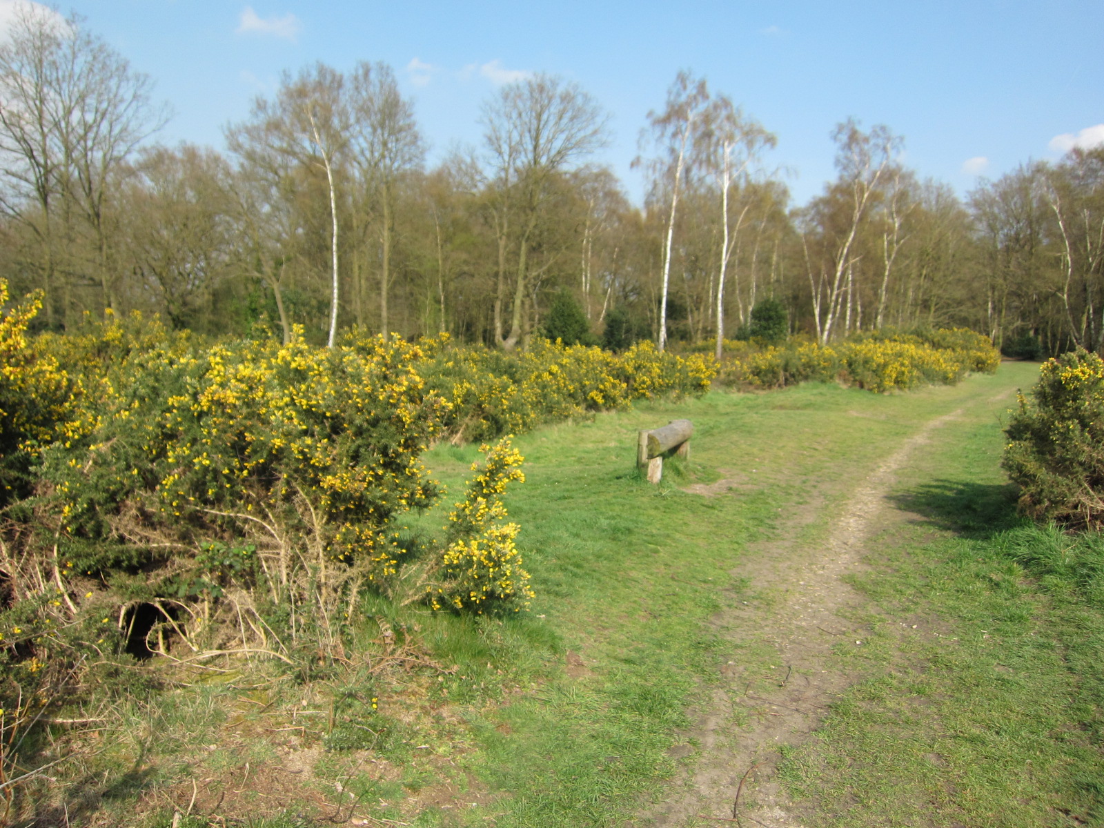
Face the Galleywood Common information board and turn left. Cross the minor road and go through the gap in the trees into the Common. Follow the wide clearing ahead. Stop when you reach a white house on the left (this is Rous Cottage). Opposite on the right is a path into the woodland. Follow this path, keeping to the right hand forks until you reach a wooden bench by a pond.
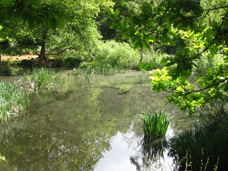
2 Marven's Pond
Galleywood Common is one of the most significant green areas in mid Essex. Its varied landscape includes grassland, woodland, heath and wetland areas like this pond.
Take a look at this sheltered spot. Surrounded by trees, it looks like a natural feature. Like much of the Common, however, this pond has been artificially shaped by people.
Our first clue is the pond’s name. Marven’s Pond is named after a local brickmaking company, Marvens, and is also known as Brick Kiln Pond. Brickmaking thrived on the Common from the 19th century until the 1940s. Old maps show several brickfields in the area.
Why was the Common used for brickmaking? One reason is its location. Galleywood is 3 miles from Chelmsford and near two major trading roads – the Chelmsford to Stock Road (B1007) and the old Maldon to London Road (Margaretting Road). Transport costs were therefore minimised.
The second reason brickmaking thrived was large amounts of clay and sand. The higher areas of the Common are made up of boulder clays, silts and sand laid down in the Eocene Epoch, 56 to 34 million years ago. While the underlying soils provided raw ingredients, surrounding trees provided timber to fuel the brick kilns.
It’s hard to appreciate how large these brickworks were as they are now filled in or covered in trees. Some though, like here at Marven’s Pond, filled with water. This is because the clay in the ground is impermeable, which means it holds water. So instead of kilns and waggons the site is now home to birds like mallards and moorhens.
Galleywood Common Brickworks by kind permission of Galleywood Heritage Centre - click on the picture to enlarge
Directions
If you have time you can follow the paths around the pond. From the bench make your way through the woods and back into the clearing. Turn right and continue along the grassed area. Pass a car park on the right and stop when you reach the end of a brick building on the left behind the fence.
3 Former race track beside Galleywood Heritage Centre
Look at the trail route and you will see that it is roughly oval-shaped. This is because it largely follows an old horse racing circuit. Galleywood Common hosted the Chelmsford Races for 176 years, from 1759 to 1935.
We are now on the old course. This building was part of the infrastructure and we will find out more about it later.
For now try to imagine the thunder of hooves and cheers of the crowd as horses galloped uphill to the finishing post, which was in this very area close to one of the oak trees.
Galleywood Common was an ideal spot for a racecourse. At the time the land was mainly treeless and so provided enough space. The high ground and underlying geology also made suitable conditions. While the higher parts of the Common are lined with clay, the slopes have gravelly soils. These allow excess water to drain into the River Wid and Galleywood Brook. This mix of soils kept the course well drained and prevented it from becoming boggy.
It is rumoured that King Charles II visited the area in 1676 and that some form of racing took place during his reign. The heyday of horseracing here was the 1860s when various buildings were constructed around the course, such as a grandstand and the Admiral Rous Inn – the white house near Marven’s Pond.
The course altered several times and over the years hosted flat races and steeplechase events over fences and ditches. In 1931 the legendary horse Golden Miller won two hurdle races over a 2-mile distance.
The meetings were successful but ran at a loss as crowds could watch for free from common land. During the Second World War Chelmsford Council purchased the course, its buildings and 116 acres of the Common. The great days of racing were over.
Pictures: Map of Galleywood Racecourse (1928)
The race course finishing straight - click on the picture to enlarge
Braintree Novices Hurdle Race at Galleywood (1920s) - click on the picture to enlarge
All by kind permission of Galleywood Heritage Centre
Directions
Continue along the grass track until you reach a road (Margaretting Road). Turn right then right again along a minor road signposted ‘car park’. Just before you reach the car park bear left and walk across the grass towards an information board overlooking a ditch.
4 Star Fort information board
Though the racecourse attracted thousands of people, Galleywood also faced the threat of unwanted visitors.
After the French Revolution in 1789 and Napoleon’s rise to power there were real fears in Britain of French invasion. The Essex coast was at the frontline of possible attack so the county’s military defences were strengthened.
If we were here just over 200 years ago this part of Essex would have been teeming with thousands of soldiers. Several large camps were set up locally, including one on the Common.
We are now near the surviving earthworks. These are the remains of a ‘Star Fort’, named after the shape of the fort’s outline. Look at the information board to get an idea how it would have looked and fitted in with the rest of the defences here.
The Common was an ideal defence site, being on higher ground and with ample building material of earth and timber. There was also plenty of land to accommodate men; in 1804 thousands were encamped here, mostly in constructing the defences.
In 1805 Britain’s victory at the Battle of Trafalgar lifted the threat of invasion. Within a decade the forts were dismantled and materials sold. Redevelopment since has destroyed almost all the evidence.
Making the Star Fort’s remains more accessible and visible is difficult - clearing too much vegetation increases the risk of erosion. There is a delicate balance between preserving and displaying our heritage.
The Storming of the Bastille (1789) during the French Revolution Wikimedia Commons (CCL) - click on the picture to enlarge
Directions
With the board behind you, walk back to the minor road bordered by small wooden posts. Turn left and continue to the end, passing a few houses on your left. Just before you reach a road (Stock Road B1007), turn left on the grassy area. Keep the road on your right and follow the grassy path beside the wooden railings. When you reach a crossroads with traffic lights, bear left and cross Margaretting Road. Enter a tree lined road ahead and follow it to a church.
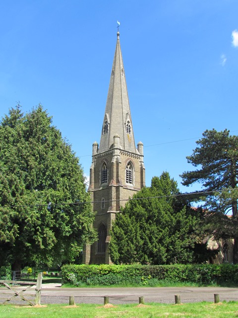
5 St Michael and All Angels Church
We are now outside one of Galleywood’s landmarks. St Michael and All Angels Church is Grade II listed and worth a visit if open. When it was built in 1873, this was Britain’s only church inside a racecourse.
Standing a commanding 277 feet above sea level, with a tower and spire 131 feet high, it’s visible for miles around.
The church used to be even more conspicuous. The number of trees on the Common has increased dramatically, especially in the last 60 years. As you can see, several now surround the church.
The change in the tree cover results from changes in the Common’s use. There were once a series of small farms adjoining the Common and their activities, including grazing animals, kept the land clear of trees.
In the 1940s, however, most of the land belonging to farmers around the Common was compulsorily purchased for housing - so the grazing stopped. Then in the 1950s a virus called myxomatosis killed off many of the wild rabbits. These changes meant trees and large shrubs flourished, which is why the Common is now much more wooded.
Today there are ongoing debates about the number of trees here and how the Common should look. A local environmental group carries out regular work to keep the churchyard tidy and in early 2014 some trees were felled to extend the graveyard.
Steeple chasing: horses passing St Michael's (1910) by kind permission of Galleywood Heritage Centre - click on the picture to enlarge
Directions
Keep the church on your right and continue along the road. Head towards a gate and pass through it. Turn left onto the grass area, another section of the old racecourse. Follow the course until you arrive at the Horse and Groom pub.
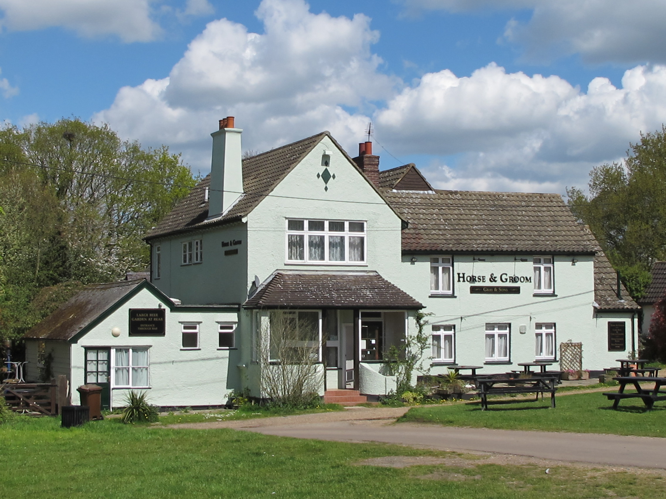
6 The Horse and Groom pub, Horse and Groom Lane
This pub was built in 1838 to slake the thirst of the Common’s race day visitors. In the 1920s and 1930s thousands of people came to Galleywood by foot, road and rail. Special trains were laid on from Liverpool Street to Chelmsford.
In 1893 the pub welcomed a very different kind of sport; Chelmsford’s first golf club was established here. A clubhouse was set up at the side of the pub and one of the professionals lived in a nearby house, Rushcroft.
The first tee and final green were outside the pub entrance. The seventh hole meanwhile was on top of a section of the Napoleonic defences!
The Common was considered ideal for golf for the same reason as horse racing. The gravel subsoils meant the course was dry and playable throughout the year. To lay out the greens some of the Common’s furze shrubs were burnt back, which alarmed passing railway passengers who witnessed the smoke. The local paper received a letter expressing concern over “wanton destruction”.
Maintaining the golf course was not always popular. There were many practical problems, including disruption caused by the steeple chasing and commoners exercising their grazing rights. In 1911 Chelmsford Golf Club moved to its present location in Widford. The club’s history is another reminder of the issues surrounding common land.
Galleywood Golf Course outside The Horse and Groom Wikimedia Commons (CCL) - click on the picture to enlarge
Directions
With the Horse & Groom pub behind you walk along the minor road as it curves to the left (ignore the right hand forks). When you reach a crossroads at Margaretting Road continue straight ahead. ‘No Through Road’ and ‘Galleywood Heritage Centre’ signs indicate the way. Stop when you see a set of gates on the left hand side at the end of a range of green buildings. This is the entrance to the Galleywood Heritage Centre.
Note: these gates are locked outside office hours. The Heritage Centre building is often used for community events and might not be accessible to callers - please check at the office.
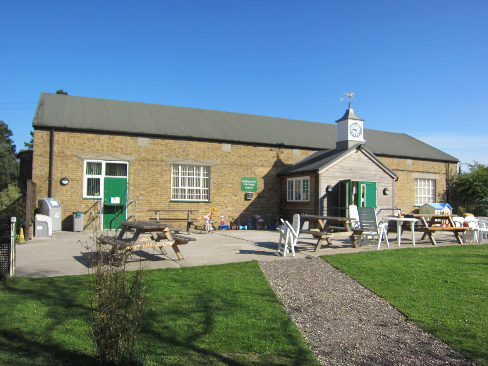
7 Galleywood Heritage Centre
Look through the gates to the building ahead. We saw the other side of it earlier by the old racecourse.
Notice the weathervane on the roof - a galloping horse. This is the remaining building of the racecourse Members Grandstand.
Constructed around 1922 it was ideally placed on higher ground that allowed up to 700 spectators a good view of the course. Besides the views, the building provided refreshments for hungry club members, jockeys and trainers.
Now look at the green outbuildings to the left of the gate. Why do you think they are so tall? These were boxes for the horses; the high doors allowed jockeys to ride out onto the track. The building used by Stables Nurseries was the jockeys’ changing rooms.
Sadly all this activity came to an end before the Second World War. When Chelmsford Council bought the Common, the buildings and grounds became a maintenance depot. Part of one grandstand was even used as a wartime morgue!
In 2009 the building was transformed into Galleywood Heritage Centre. It houses Galleywood’s archives collection and is used by various organisations. If the gates are open please enter the grounds for a closer look. The Heritage room in the Centre has displays on local history and there is a seasonal tea room in the main hall.
Throughout this trail we have found out how Galleywood Common has been used for horse racing, brickmaking, farming the land and defending the nation. In each case the Common’s location, the lay of the land and the geology under our feet have played a part. We also discovered how each activity has affected the Common’s appearance, from creating ponds and trenches to growing trees.
Over the years the Common has been used in many different ways - sometimes all at once, which has led to disagreements. Many other commons in Britain face similar conflicts of interest, as different people want to work, play and relax on them.
The debates around commons reflect those around land use nationwide. Should land be left to develop naturally or be carefully managed? Should land be used for people to make money or for people to enjoy for free? Should more open spaces be used for housing?
How would you like to see these spaces being used?
Whatever your feelings, we hope you have enjoyed this trail and exploring Galleywood Common’s uncommon stories.
If the Heritage Centre is open do feel free to visit. To return to the car park, continue along the road with the Heritage Centre on your left. Pass a house on the right (Farthings) until you reach Rous Cottage again. Walk onto the grass of the Common in front of Rous Cottage. Continue downhill, cross the minor road and the car park will be ahead.
Your browser is out of date, and unsupported by this website. Please upgrade to the latest version to use this website.
Start of a race at Galleywood (1930s) by kind permission of Galleywood Heritage Centre
Galleywood Common trail
A short walk exploring a unique Essex common
Galleywood Common is a pleasant open space enjoyed by walkers, cyclists and horse riders. Though it is tranquil today the Common has a surprising history.
The land has been trampled by racehorses and farm animals, dug up to make bricks and taken over by the military. The Common has changed use and appearance many times for many reasons.
This trail explores why. It was created by Susan Wilson, who has lived in Galleywood for over 30 years, with other volunteers and Trustees of the Galleywood Heritage Centre.
Follow the trail by clicking on the map pins or downloading the guides below
Galleywood was England's only racing circuit around a church. 'Steeplechasing' began when pairs of horses raced between village churches - jumping over any obstacles in the way
, Wikimedia Commons (CCL)")


 by kind permission of Galleywood Heritage Centre")
 wikimedia.jpg)
 by kind permission of Galleywood Heritage Centre")


 John Cummin.jpg)
