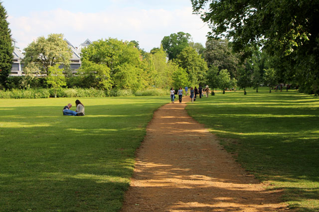
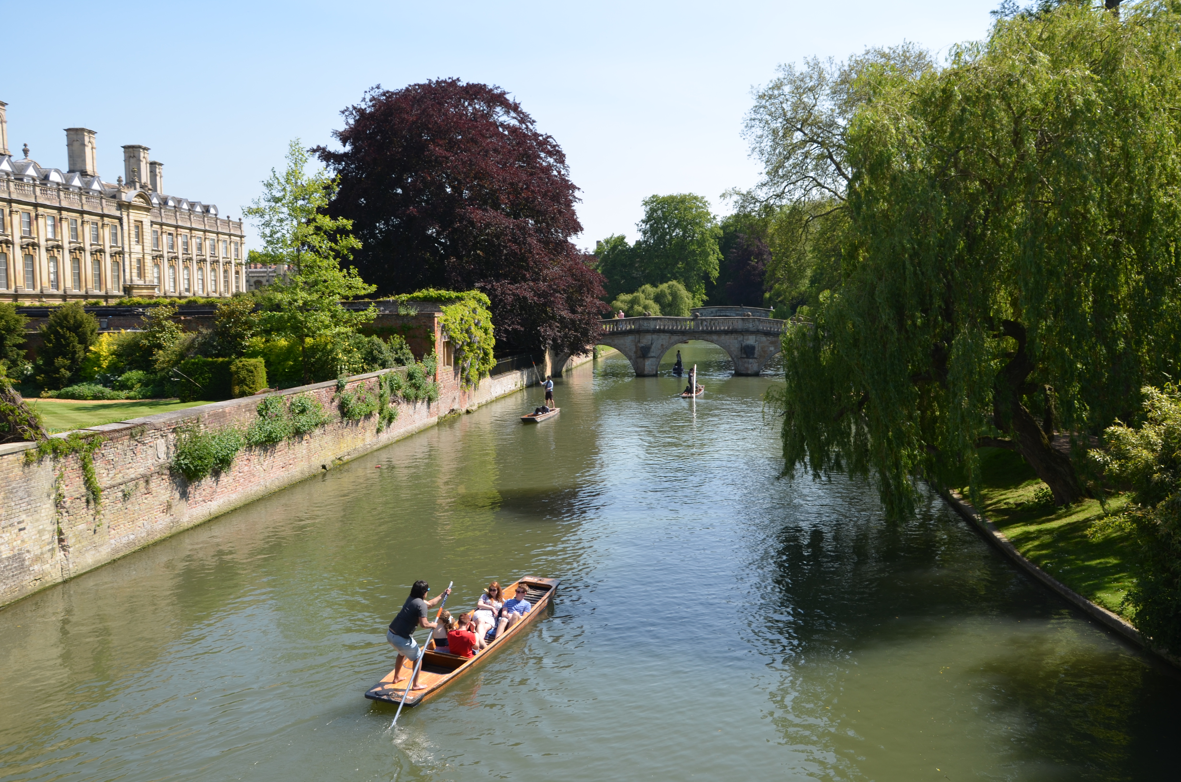
You are in the area called ‘the Backs’, where the River Cam flows through the grounds and gardens – or ‘Back Greens’- of several of the University’s largest colleges. The modern bridge on which you are standing was built in 1960 and provides the only public right of way across the river in the Backs. It gives fine views along the river towards Trinity College to the north and Clare College to the south.
Watching the Cam today, with its punts full of photo-snapping tourists, it is hard to believe that the marsh town of medieval Cambridge drew its lifeblood from the river. This represented its chief trade route to the North Sea. Imagine the busy scene on the east bank when it was lined with wharves and the land behind occupied by closely packed houses and narrow lanes.
This all changed when Henry VI planned King’s College in the 1440s. He authorised the clearance of the town between the water and the High Street, now King’s Parade. From this time on most of the older university colleges came to dominate the east side of the river. As the west side was developed for gardens and parkland belonging to the colleges, each was linked to its grounds by a bridge across the Cam.
Facing you as you cross the bridge is Trinity Hall and its recent addition, the Jerwood Library. How successfully do you feel this redbrick extension, completed in 1998, fits into its surroundings? Although it occupies a tiny, but prominent site, the harmonious design and attractively traditional materials help it to blend naturally with the neighbouring older buildings.
This small example typifies the challenge Cambridge faces today – how should it develop to meet the needs of its population, both students and residents, without damaging the city’s architectural heritage?
Follow Garret Hostel Lane to its end and turn left into Trinity Lane. Go round the corner with the walls of Trinity College on your left. Turn left into Trinity Street, which shortly becomes St John’s Street, and pass the impressive main gateways to both of these colleges on your left. Turn left into Bridge Street.
2 Bridge Street and Magdalene Bridge
As you stroll down Bridge Street you will see a line of Tudor buildings on your right. Nowadays each has its own style and décor, and they house bars, restaurants or shops. These properties were threatened with demolition in the 1970s, a time when planning imperatives afforded traditional housing little value. Fortunately they were preserved, and all of them retain most of their original timbers.
Continue walking down Bridge Street to Magdalene Bridge
When you reach Magdalene Bridge, look downstream with Magdalene College on your left and Quayside on the right bank. Magdalene is pronounced ‘Maudleyn’, a fine piece of vanity that recalls Lord Audley of Walden, Henry VIII’s Lord Chancellor, who re-founded the college in 1542.
Opposite the college, Quayside is the sole remaining evidence of the city’s trading past. Cambridge was at the head of river navigation and barges travelled upstream from King’s Lynn, which traded with London and Scotland, from medieval times onwards. The Quayside development shows the impact of modern building on this historic location, where the muddy river bank has been replaced by luxury flats and a café quarter around the punt stop.
However, this location on the Cam goes back to the very origins of the settlement. An ancient ford, where Magdalene Bridge now stands, attracted Belgic invaders to occupy a nearby strategic hill in the first century BC. The Romans established a garrison encampment on the hill a hundred years later and subsequently built a new town. The Roman road leading south from York and Lincoln, crossed the Cam at the ford. It is likely that the Romans built the first bridge across the river, which during Anglo-Saxon times would have linked East Anglia and Mercia.
By the time of the Norman invasion in the 11th century, two distinct settlements existed: the port on the east bank and the fortified township on the hill to the northwest. The Normans built a ‘motte and bailey’ castle on the hill and the Domesday Book recorded a settlement of 370 houses around the stronghold. From these modest beginnings, Cambridge has grown into a city with over 125,000 inhabitants.
Re-trace your steps back to the end of Bridge Street, where you will see a most unusual church.
The Church of the Holy Sepulchre, the Round Church, is a Norman church with a circular nave, the oldest of only five such churches in the UK.
Carry on straight ahead into Sidney Street, following a block of modern shops on the left, then cross the junction with Jesus Lane. You will pass Sidney Sussex College on your left. Take the next turning right into Green Street.When you exit Green Street turn left into Trinity Street. Stop outside Michaelhouse’s blue sign on the left.
Michaelhouse was originally the second residential college to be established in Cambridge, but on this trail, its recent alteration in use is of interest to us. The early 14th century collegiate church united with Great St. Mary’s in 1908 when its parish became too small. In 2001-2 it was converted into a multi-purpose building. It is now a gallery, small performance space and café and is still occasionally used for church services. Michaelhouse is a quiet testament to how the city is changing in more subtle ways.
Continue along Trinity Street, passing Gonville & Caius College on the right. As you emerge on to King’s Parade the street widens significantly, with Great St. Mary’s church on your left.
3 King's Parade
You have now reached one of the most iconic vistas in Cambridge. Immediately to your right is the early 18th century Senate House, the official centre of the University. Next to it are the Old Schools, where an 18th century facade masks the medieval buildings that housed the first university administration and library. Beyond them is the glorious panorama of King’s College, usually besieged by throngs of tourists along King’s Parade. Before you venture to join them, take a minute to look at the church to your left.
Great St. Mary’s lives up to its name with one of the best vantage points in the city atop its tower. This University Church was completed in 1205 and remodelled in the 15th century, with the west tower being added in the first half of the16th. Many churches have received similar treatment, changing in size and design over the years to accommodate new architectural tastes and requirements.
Looking down King’s Parade, can you see how straight the road runs? It goes all the way from St. John’s southwards to Trumpington Street and beyond. This, of course, reveals its Roman origins, for the medieval High Street followed the line of the old London road. The High Street would have been narrow with rows of tall, timber-framed houses lining both sides. When the land was cleared to build King’s College, all the buildings on the west side were swept away. Imagine the impact this would have had on the medieval population! It is interesting to compare this to how communities today react to large redevelopments in their city centres.
From the front of St Mary’s take the right hand passage alongside the church into Market Hill. Walk past the Guildhall (1938) on your right and straight into Petty Cury, originally a medieval street, now lined with modern shops on the right hand side. Stand on the corner of the market square and Petty Cury.
4 The Market Place and Lion Yard
Facing you are the candy coloured canopies of the daily market, a part of the city’s heritage that dates back to Saxon times. The goods on sale are largely necessities – food, clothing and the like – but the market still acts as a hub for Cambridge’s thriving retail district.
A huge shopping centre was originally proposed here in the 1950s to modernise Cambridge’s retail facilities. It was reduced in size following protests and a planning enquiry. Even so, demolitions in the 1960s flattened an enclave of timber framed buildings and narrow yards, including the Red Lion Inn – hence the name Lion Yard. The 1970s shopping centre, refurbished in 1999, replaced a thriving district of discos, clubs, cafes, restaurants, small offices and independent shops.
Walk along Petty Cury. The first turning on the right takes you into Lion Yard. If you continue straight ahead you will enter the Grand Arcade, a larger and more lavish shopping mall opened thirty years later. Go through the centre, exiting its flagship John Lewis store by following signs onto Downing Street.
You will have realised that the shopping centres you just passed through could actually be in any UK city. The brightly lit facades with national chain stores and expensive ‘designer’ shops represent a typical ‘clone town’ environment. These retail developments have helped maintain the commercial attraction of Cambridge but higher rents and rates have driven out independent retailers. Although the city still has a strong commitment to independent shops, the ‘clone town’ syndrome has had an undeniable effect on the way this area looks and feels.
Turn right and cross the road, passing the Sedgwick Museum of Geology and the University Museum of Archaeology & Anthropology. Turn left into Tennis Court Road. Carry on down this road, between Pembroke College and the university departments, before turning right down Fitzwilliam Road. Follow this to the end where you will reach Trumpington Street.
5 Trumpington Street
When you enter Trumpington Street, pause for a minute to appreciate the view in both directions. There is a perfection in this road’s built environment that exemplifies the very best of Cambridge. Among the pleasing variety of urban styles, two large buildings stand out.
Walk first just down to your left and notice the large building set back from the road.
This is the Cambridge Judge Business School. Home to the University’s most recently established academic department, it has occupied the former Addenbrooke’s Hospital building since 1995. The hospital was founded in 1766 and extended through the early 19th and 20th centuries. In 1984 Addenbrooke’s moved to a more extensive site on the southern edge of the city, leaving the original building vacant.
It could so easily have been destroyed for redevelopment but a visionary refurbishment has given it new life. An ingenious adaptation of the previous corridors and wards was combined with a colourful approach to interior and exterior decoration, producing a distinctive post-modern appearance. Whether you think the 1990s development sits comfortably here or you find its pinks and greens jarring, the Judge Business School certainly makes an impact.
Turn back the way you came to face the imposing baroque frontage of the Fitzwilliam Museum, once described as ‘the finest small museum in Europe’.
Built over the first 35 years of Queen Victoria’s reign, the Museum was funded by a bequest from Viscount Fitzwilliam of Merrion. After graduating from Trinity Hall Fitzwilliam embarked on his Grand Tour – a journey through Europe’s cultural treasures taken by many an aristocrat of the Victorian age. The museum was originally designed to house the collection of paintings, books, prints, manuscripts and objets d’art with which he returned from his travels. Since then there have been several extensions, the latest in 2003/4, which created a modern wing featuring a beautiful, naturally lit covered courtyard.
These two contrasting buildings are both significant landmarks which add to the character of the historic city centre’s southern approach.
Follow Trumpington Street north past Peterhouse, Cambridge’s first college, then turn left down Little St. Mary’s Lane. Turn right at the end into Mill Lane, with the University Centre on your right. As Mill Lane makes a right angle turn, go straight ahead into Laundress Lane, a narrow pedestrian alleyway that leads to Silver Street. Turn left onto Silver Street Bridge.
6 Silver Street Bridge
Silver Street’s medieval name was ‘Smallebriggestrate’ – Small Bridge Street – to distinguish it from Bridge Street at Magdalene College. The two riverside pubs - The Anchor and The Mill - give you a clue as to what this area was used for. The bridge overlooks the Mill Pool, where corn and flour were loaded onto barges from the bustling medieval wharves beside the mill.
Silver Street also marks the southern edge of the former King’s Ditch. This was the boundary of the medieval town which ran from the Cam near Magdalene College, across the modern city centre towards the river. The King’s Ditch was chiefly built during the 13th century, in the long reign of Henry III. It ensured that travelling traders heading for Cambridge’s markets had to pay tolls when they passed through the gates.
From your vantage point on the bridge, consider the impact of two modern university buildings on their surroundings. Looking back the way you came, you can see the Cambridge University Centre, a social centre for graduate students.
Built in 1967, the ‘Grad Pad’ makes no concessions to its setting on the historic Mill Pool. What is your reaction to its ‘brutalist’ architecture, in terms of both size and materials? One disgruntled long time Cambridge resident has described it as ‘a perfect example of a building in the wrong place’!
The view in the other direction is one of the most photographed on the tourist trail. To the right of the river are the old buildings of Queens’ College and, spanning the Cam, the famous wooden ‘Mathematical Bridge’. No nails were needed for its construction in 1750, its strength being derived from carefully calculated strains. But look to the left, where the concrete and glass Cripps Court dominates the southern end of the Backs in uncompromising fashion. Built in an unashamedly brutalist style between 1972 and 1988, it represents the largest modern intrusion into the sequence of picturesque older college buildings lining this part of the River Cam.
From Silver Street Bridge follow the footpath to the right around the back of Queens’ College and stop on Queens' Green (the grassy area behind Queens' College).
7 Queens' Green
Your walk has taken you through the city centre, illustrating many of Cambridge’s architectural glories and the prevailing sense of history conferred by the University. At the same time you will have been aware of the obvious threats to this precious environment: the intrusion of traffic on a medieval street plan, vehicle noise and pollution, the weight of tourist numbers in ‘honey pot’ locations, the commercial pressures for inappropriate building developments.
Nevertheless, there is a bigger picture playing out in Cambridge as a whole and the surrounding countryside. Speculative residential and commercial property schemes, fuelled by sky high house prices and rent levels, are having a major impact on the urban fabric. Cambridgeshire’s population is predicted to rise by over 20% in the next 15 years and tens of thousands of new homes are planned on the city fringes, in existing villages and two large new towns throughout the county.
Pressure on the city is mounting and its unique character is looking increasingly vulnerable.
Continue across Queens' Green (walking away from Silver Street Bridge) until you join Queens' Road. Turn right onto Queens' Road then take the first left into West Road where you parked your car.
Your browser is out of date, and unsupported by this website. Please upgrade to the latest version to use this website.
Cambridge is home to a celebrated University but is also a world famous tourist destination, and a major retailing, administrative and entertainment centre. The city’s economy is booming, giving rise to population and employment growth, with the associated problems of congestion and development pressures.
This trail takes us through the heart of Cambridge, passing many of the striking buildings that have been completed during the last 800 years.
Do modern buildings enhance or compete with the Cambridge you expect to see? With increasing pressures on the city’s infrastructure, can historic Cambridge survive?
Follow the trail by clicking on the map pins or downloading the guide below
Cambridge University and city centre, Cambridgeshire
Grid Reference:
TL 44332 58174
Start:
Garret Hostel Bridge, Garret Hostel Lane, CB2 1TJ
Finish:
Queens’ Green, CB3 9AJ
Parking:
Street parking is available in West Road, CB3 9DS. There is a maximum 4 hour stay in West Road. Parking along Queen’s Road is more expensive, as are the multi-storey car parks in the city centre.
Directions to Stop 1:
From West Road, walk to Queen's Road and cross at the pedestrian crossing. Turn left past the rear gate of King's College and continue along the unsurfaced footpath that follows the drainage channel on the edge of the college grounds. Pass the rear gate into Clare College and continue until you reach Garret Hostel Lane. Turn right along it, walking in the direction of the main university buildings. Stop when you reach the bridge over the River Cam.
Cambridge trail credits
Thank you to:
Michael Morrish for writing and photographing this trail
Jo Kempfor supplying extra photographs and editorial suggestions
"Cambridge is one of the few places where one can talk unlimited nonsense and generalities without anyone pulling one up or confronting one with them when one says just the opposite the next day" - Bertrand Russell
 Facing you as you cross the bridge is Trinity Hall and its recent addition, the Jerwood Library. How successfully do you feel this redbrick extension, completed in 1998, fits into its surroundings? Although it occupies a tiny, but prominent site, the harmonious design and attractively traditional materials help it to blend naturally with the neighbouring older buildings.


.JPG)


 - Copy.JPG "Queens College")