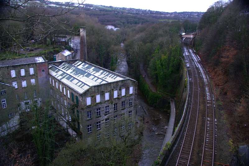
This is a great spot to take in an overview of our journey - and this is an overview, in every sense! The dominant old industrial building one hundred feet below is Torr Vale Mill, with the River Goyt swirling past it in a dramatic curve. Next to the mill is the railway line which links Greater Manchester and Sheffield, via a two-mile long tunnel under the high moors of the Peak District.
Hanging precariously between the two and directly over the raging river is the newest addition to this complex landscape. It’s just a thin ribbon from this distance, but will provide the highlight of this trail’s end...
For now, lift your eyes to the near horizon. Can you see what seems like something straight out of an LS Lowry painting, the mill with its tall brick chimney? If the wind is from that direction, give the air a sniff. Any smells that take you back to your childhood? Refreshers? Love Hearts?
Well, believe it or not in this age of globalisation, sweet manufacturers Swizzels Matlow still produce these favourites from that factory as they have done since 1940.
They employ around 500 people and export all over the world. The business is even expanding into a neighbouring site. The brick-and-stone mill itself is far older than the Second World War, belonging to New Mills’ long period of growth during the Industrial Revolution. We will follow that story of growth, construction, decline and rebirth as we continue.
But what was it that kick-started all of this activity? The answer lurks in the powerful forces of nature way down below…
Walk along the pavement towards the New Mills Heritage Centre on the corner (this is a must visit at the end of the trail). Walk down the fifty-one steps to the bottom of the gorge and turn left for the rock face and viaduct arches.
2 The rock face in the Torrs
What a complete change of atmosphere down here at the bottom of the gorge! The noise of the town is completely drowned out by the cascades of water. The sound is echoed off these tall stone cliffs and massively impressive viaduct arches.
Take a look at their stonework and then back at the rock face. Yes, it is indeed the same kind of rock, a tough sandstone. All of it was quarried right here. What would have been a much narrower gorge has been made wider from quarrying, leaving quite a smooth surface – now a proper challenge for local rock climbers.
One of this sandstone’s features is variability; some of it is coarse-grained, suitable for those massive blocks in the pillars, while elsewhere it is fine-grained and ‘flaggy’ – in other words it can be split into thin slices. Stone floors and even roofing slates for houses and mills could be made from this type.
A large proportion of New Mills’ important structures and buildings were built from this very local stone, known as Woodhead Hill Rock. Sourcing local materials is very much part of the Green agenda in modern times; two hundred years ago, it was the norm.
So the industrialists who caused much of this cliff face to turn black from the soot of their coal fires at the same time saved huge amounts of energy by not transporting stone from faraway places.
But take a look at the rock just past the remains of that old wall. Why didn’t this area turn black too? The completely clean lower section can only have been inside a long-vanished building, built right against the rock face. The air outside must have been almost unbreathable.
Exactly what kind of building it was we shall discover when we return this way. First, we need to understand why anything was built down here at all in this highly inaccessible spot.
Pass under the viaduct, go past the big weir and then turn right to cross over the River Sett via the wooden bridge. Follow the wide path upstream along the River Goyt, under the tall stone road bridge to arrive at the old weir.
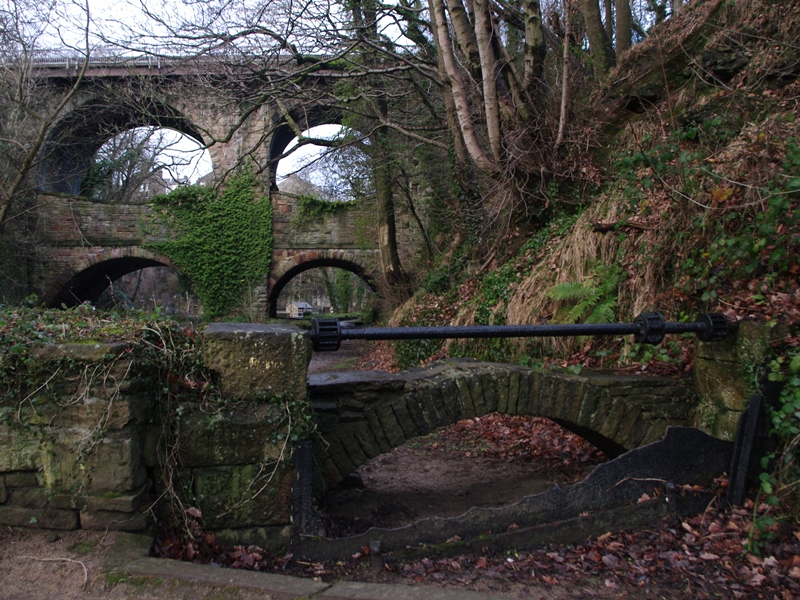
3 The old weir
This old weir, charming though it is, was much taller when it was constructed in the eighteenth century. Now turn to the other side of the path. What was the purpose of the strange iron mechanism with the low arch just behind?
The smooth wide track we walked along just now wasn’t built for the passage of feet, but water. With a weir forming a dam in the river, the flow was diverted along this channel, known as a ‘leat’.
The horizontal shaft there was part of the winding gear for a sluice gate, the remains of which are sticking up from the ground directly below. The sluice gate was an iron barrier that could be cranked up or down to control the amount of water flowing into the diversion.
The power of water had been harnessed along these rivers for centuries, chiefly for milling corn. Water was the obvious choice for driving the machines of the early Industrial Revolution. The name New Mills does not stem, as you might think, from the huge buildings we saw from up top. There is a record of a water-powered corn mill further up the River Sett as far back as 1390.
When a second one was built, nearer to The Torrs, it became known as ‘New Milne’. So, the growing town had already acquired its name when manufacturers eyed-up all this free water power during the 1780s.
The stone for construction, as we have seen, was just to hand and easily worked. Quarrying cleared enough land to provide the first cotton mills with a large enough plot, so it really was a win-win situation.
The only real difficulties they faced were the flammability of their products – cotton, linen, paper - and the very nature of the terrain: a deep gorge. Getting raw materials down and manufactured goods back up took teams of powerful horses. The two arms of the gorge also acted as serious transport barriers around the district.
To solve this, the bridge you see behind the sluice, with its curious double arches, was built in 1835. Before then locals would have taken a winding path, like the one we took today, just to cross town.
Take a brief look upstream to yet another impressive stone viaduct. It carries one of four railway lines which cut through the small town and was built as late as 1902.
The water power present in the heart of New Mills provided the seed for a very long period of industrial growth, well into the age of steam. In the local sandstone, entrepreneurs had found the right material to create a highly complex web of transport links by road, canal and rail.
We are going to walk back along the old leat now, imagining ourselves as water; let’s see where we end up…
Retrace your steps to stand on the wooden footbridge.
4 The Millward Bridge
This small wooden bridge was built in the early 1970s when the whole of The Torrs was reimagined as a “riverside park”. It is named after Dr Millward who was the chief proponent of the ambitious plan.
Before Dr Millward and his team started campaigning in the 1960s, the entire complex of mills and bridges had fallen into such a terrible state of ruin and pollution that the whole gorge was effectively closed.
Long before then, the leat water continued its journey over the River Sett (below) via an aqueduct and on into Torr Mill. This is not to be confused with the huge Torr Vale Mill we saw from above, though it was just as big.
We can still make out a few of Torr Mill’s walls, built from 1794 onwards. We were looking at one earlier; remember the clean section of the former quarry face?
By the early nineteenth century there were three major mills in The Torrs. As they expanded and needed more power, all of them were at least partly converted to coal-fired steam. There were cottages and small workshops down here too, all burning coal. That’s when the blackening of the rock started.
Going for a walk in The Torrs must have been more like a descent into hell. Coal, unlike water, had to be got down here, adding to costs, while it also added to the risk of fire.
So, for a variety of reasons, not least the increased competition from even larger mills elsewhere, The Torrs’ industries went into a long period of decline. Ultimately, the narrow confines of the gorge left no room for growth.
In 1912 the whole of Torr Mill was destroyed by a disastrous fire. Fire, steam, water, rock and, these days at least, beautifully fresh air… Take a lungful! The Torrs truly is an elemental place and a great asset to the modern town, both in terms of informal recreation for the locals and as a tourist attraction. The Midshires Way and the Sett Valley Trail pass right through.
Standing here today, you may well spot such birds as dippers, grey wagtails and kingfishers, all indicating something of a return to the gorge’s more natural state. Talking of natural forces, let’s head towards the source of all the noise…
The head of water behind this big weir once provided the power for another mill just downstream. This thunderous cataract, at the confluence of two rivers, is a good place to think about the elemental forces which gave rise to this landscape.
It is hard to believe today but the River Goyt once took an entirely different course. Where we stand now would have been nothing but solid sandstone. The change came 2.5 million years ago when the Earth went through a series of Ice Ages. The planet’s temperature dropped and vast areas were covered in huge ice sheets.
Here at The Torrs, the titanic movement of an ice sheet swept along a huge quantity of boulder clay. Clay is impervious to water. This effectively dammed the previous course of the river.
When the ice finally started to melt, around 10,000 years ago, the newly resurgent Goyt was forced to find another route down towards the Mersey. It found it through a line of weakness in the Woodhead Hill Rock.
The easily-worked sandstone was just as easily eroded by the fast-flowing Goyt and Sett rivers, fed by all that melting ice. The result was this swiftly cut, deep and narrow gorge.
In modern times, our growing concern about the burning of fossil fuels has seen a swing back towards using water’s natural, pollution-free power. A very neat example is the small stone building right by the huge weir. It is the UK’s first community owned and run hydro-electric plant.
The plant uses a reverse Archimedes screw to produce 500,000 units, (kWh) of electricity a year. That’s enough energy, from that short fall of water, to power fifty average homes.
In reality it is all bought by the Co-op superstore up in the town, with anything they don’t use going to the National Grid. There is even a fish ladder to help migrating trout upstream, while the screw itself has been certified as ‘fish-friendly’ for those heading down. Things really couldn’t get much Greener!
Follow the Goyt downstream a short way, back under the viaduct (Union Road Bridge). Pass the flight of steps you came down, and continue to the start of the long steel structure over the river.
6 The Torrs Millennium Walkway
We come finally to The Torrs’ star tourist attraction: the Millennium Walkway. Its long sweep of shining steel takes us over one of the noisiest of the Goyt's weirs, at a dizzying height. It came about through yet another community-driven initiative and is an inspired way of linking the riverside park with the trains at Central station and Torr Vale Mill.
The vast edifice of Torr Vale Mill, just across the river there, started as a water-powered cotton mill in the 1780s. It was converted first to steam, then to electricity and spun its last yarn in 2000.
That’s the oldest part, facing us, with typical Georgian rectangular windows. The former mill race passed through that stone arch just below it, to the right.
These days it is a venue for conferences and events, with holiday accommodation in the former cottages and workshops behind. A fitting reflection then of the gorge’s entire, rich history, brought right up to date in the twenty-first century, viewed from this state-of-the-art bridge.
There are plans afoot for yet another new footbridge, bypassing that path you may have noticed was shut. The rock face above the path has been declared permanently unstable, but a new crossing of the river would restore the route of the Sett Valley Way. Typical of New Mills’ spirit, this kind of thinking and community action has kept the town very much alive through more than two centuries of change and reinvention.
As you enjoy the experience of suspension, walking over the Goyt to the end of our trail, let the sound of its powerful waters be a concluding reminder of the source from which New Mills’ prosperity, growth and modern rebirth sprung.
Don’t forget to visit the Heritage Centre if you have time. It is well worth the effort for the amazing miniature model of The Torrs in its heyday. A chat with the enthusiastic volunteers who run the place will also prove enlightening.
Continue along the walkway to the end, then turn right. Cross the road into New Mills Central station or go back up the hill of Station Road to reach the Bus Station.
Your browser is out of date, and unsupported by this website. Please upgrade to the latest version to use this website.
As small towns on the edge of the Peak District go, New Mills doesn’t seem to have anything special on its ordinary-looking surface. Walk just a few steps in a downwards direction though and all of that changes.
Running right below the main shopping and residential streets is an astounding natural feature - The Torrs. Our trail ventures into this deep gorge cut by two powerful rivers, the Goyt and the Sett.
With ears soothed by the constant tumble of water over rock and weir, the atmosphere below is instantly refreshing. Colourful cliffs and enormous, eerie viaducts loom overhead. But things were not always quite so enchanting…
Follow the trail by clicking on the map pins or downloading the guide below
Simon Corble for creating and photographing this trail. Simon, a theatre director, playwright and actor based in Derbyshire's Peak District, is passionate about the countryside and discovering the hidden secrets of the natural world.
The author Edith Nesbit visited friends all around New Mills and got the idea for her classic novel The Railway Children from the stretch of railway between New Mills Central and the village of Strines
 Well, believe it or not in this age of globalisation, sweet manufacturers Swizzels Matlow still produce these favourites from that factory as they have done since 1940.
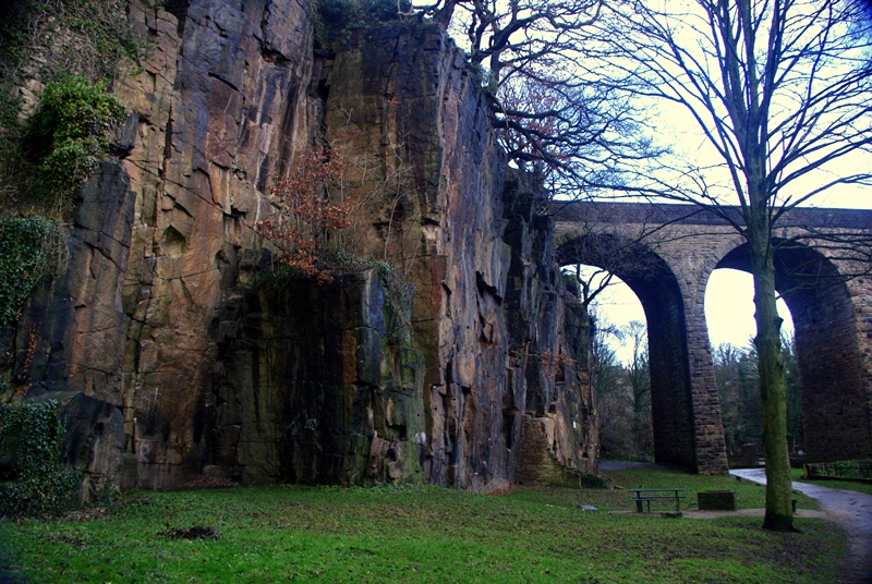
 Take a brief look upstream to yet another impressive stone viaduct. It carries one of four railway lines which cut through the small town and was built as late as 1902.
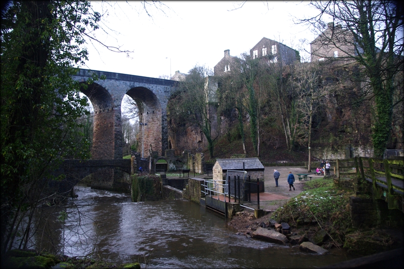


 That’s the oldest part, facing us, with typical Georgian rectangular windows. The former mill race passed through that stone arch just below it, to the right.
