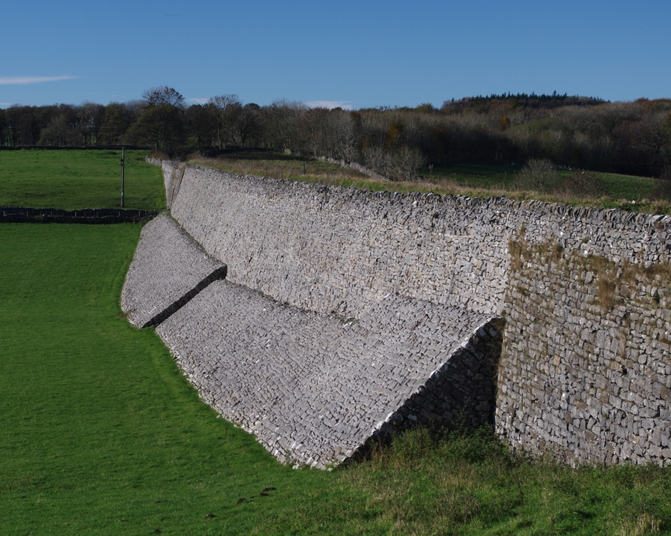
Having passed over the narrow embankment, with its terrifying drops either side, this is the point to look back and admire the effort which went into its building.
There is something incredibly ancient about this structure. Completed in 1831 it is ancient, in railway terms. But it speaks of something almost prehistoric.
We are used to nineteenth century railway architecture looking very precise; highly engineered, made of uniform brick. This is nothing of the sort. Now look at the wider landscape. Why does this structure seem to fit in so well?
The builders must have borrowed from the deceptively simple and centuries-old technology of the drystone wallers. Walls made of local limestone criss-cross the green fields around us in all directions.
Getting bricks and mortar way up here would have been a laborious and very expensive task. The stone wallers only had to dig small pits right next to where they were building to find enough material. There was no need for mortar either, if they used their traditional skills to cleverly lock the whole structure in place.
But look at the quantity of stone in that embankment. Where did that lot come from? Behind us on the hillside are the remains of an old quarry, which almost certainly provided the bulk of the stone. Perhaps some of it also came from the site of our second stop...
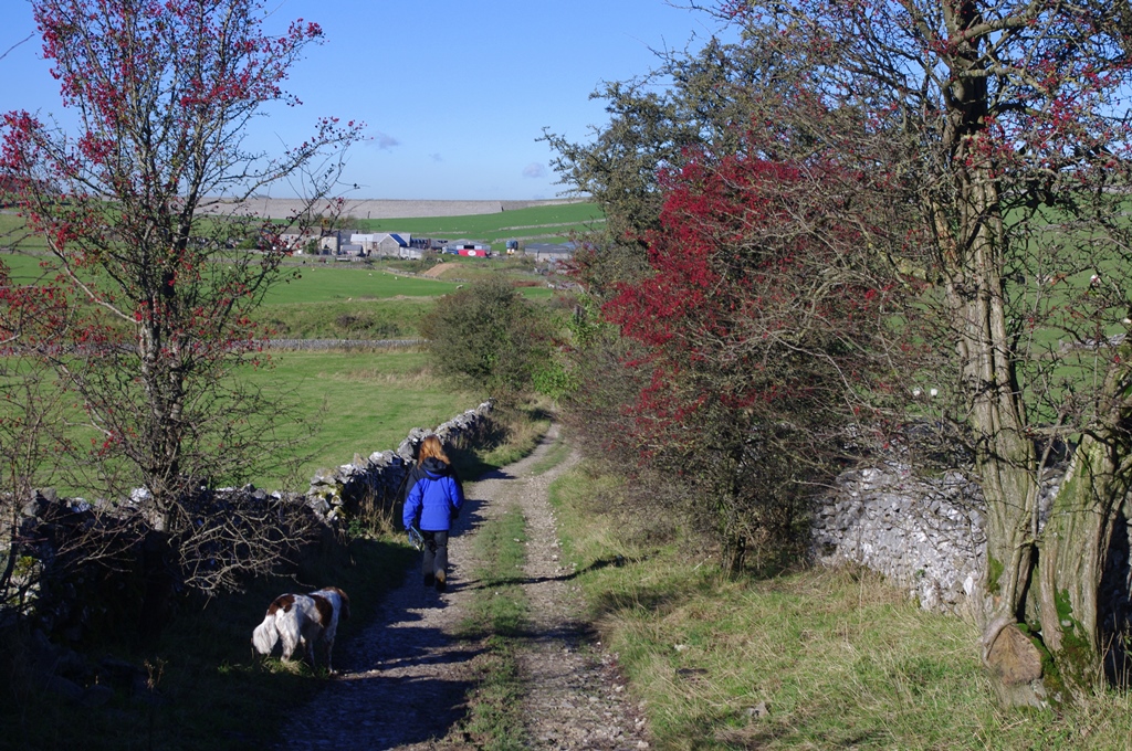
Continue along the High Peak Trail a few hundred metres until the path enters a sudden, deep cutting.
2 The cutting (SK 20482 57663)
There’s a dramatic change of atmosphere here, as the former railway line slices through a small spur of the hill. At this point we are literally walking through a cross section of the very material of the White Peak: Carboniferous limestone.
Run your hand over the surface of the rock. It can be highly variable across the White Peak but this is tough, top grade building material. Almost certainly the spoil from this cutting was used in one or both of the huge embankments on our route. The builders may indeed have deliberately carved through here to get at the high quality rock rather than take a diversion.
It is mind-boggling to think that this great mass of rock was formed from the remains of tiny sea creatures, which lived in a tropical sea here around 340 million years ago. At that time coral reefs and small sea creatures flourished. As these creatures died, their shells and hard bony parts built up in layers on the sea bed. Over millions of years these layers were compressed to become hard limestone rock.
The first part of the rocks’ name is another link to the bygone age of steam. ‘Carboniferous’ means ‘carbon-bearing’ – in other words, coal. This kind of limestone is associated with coal measures. Coal was the essential fuel of the Industrial Revolution, which was at its height when this line was first running.
Coal was not found here, but not far to the east in the Derbyshire coalfields. This ‘black gold’ would have been one of the line's most important cargoes, as well as providing power for the steam engines. Let's steam ahead a very short way – more of a shunt, really...
Continue a few metres further on to the old crane beside the path.
3 Crane at the quarry (SK 20512 57627)
We are now looking up at the remains of a sizeable quarry, complete with a rusting crane which once loaded the limestone blocks onto trains.
This is a typical Peak District scene. If you follow the High Peak Trail all the way to its northern end, just outside Buxton you will run into some truly vast quarries still in operation. They load directly onto a dedicated ‘mineral line’, just as happened here. Such railways are a much greener option than road transport.
Looking at the map, you may notice the route of the old railway seems to snake around all over the place. It’s quite unlike the normal pattern of straight rail lines we are used to. This is because the engineers who designed the line were not railway builders, they were canal men. The whole idea of the line was to link two busy canals - the Cromford Canal, to the east of the plateau, with the Peak Forest Canal to the west.
In order to make the gradients as easy as possible they followed their habitual method of following the contour lines of the hills. This made perfect sense for the very slow movement of water and canal traffic; less so for a railway line, which had to cater for faster and faster steam locomotives. But then the first goods trains were pulled along here by horses, not steam engines.
Plodding horses had no problem coping with the railway’s curves, the tightest on any conventional British line. The metal tracks were laid not on the wooden sleepers we are more familiar with today, but on stone blocks, leaving a smooth central track bed. Sleepers would have been a trip hazard for horses and only came into fashion as steam locomotives took over.
When the line was started, however, the only steam engines were stationary ones on the steep inclines into the Derwent Valley. One can still be seen in action today, preserved at Middleton Top, above Wirksworth. We are going to sample a typical Peak District gradient now, by leaving the line and ascending Minninglow.
Just at the end of the quarry, leave the trail, following the concessionary footpath signs up the hill to the left, over the pastures and all the way to the top.
4 Minninglow Hill summit (SK 20948 57277)
Surrounded by a magical ring of beech trees, the hilltop is littered with strange slabs of pale limestone; they could be teeth extracted from some stone giant. Take a closer look and you will see that they are not like the random blocks we passed on our way up here, but deliberate human constructions.
These are Neolithic tombs, dating from around 3,000 BC. They developed in a growing complex, which eventually became one big circular mound during the Bronze Age (1,200 to 700 BC). The hilltops or ‘lows’ of the White Peak were sacred places to its prehistoric inhabitants. After much looting and destruction this is a desecrated scene today, but many of the tombs retain their distinctive form. Take a peek under the slabs.
According to the OS map, almost every major height in the area is crowned with such a ‘tumulus’. This place would have seemed much less bleak in the Bronze Age than it appears today; the climate was a good deal warmer and the higher places were the first to be cleared of impenetrable ancient woodland.
Six miles to the northwest is the impressive stone circle and burial complex of Arbor Low, at the same altitude as Minninglow (around 375 metres above sea level). It is no surprise then that an ancient trackway – marked on the OS map as ‘ROMAN ROAD’ but in fact much older – ran from Arbor Low and past the base of this hill, on the other side to that of the railway.
Here and there its course is still part of a rough track today, but most of it has vanished. Another crossing of the plateau that was more or less abandoned as civilisation and trends moved on, just like our railway was. Let's go back down, via a different footpath, to find yet another crossing.
Look for the concessionary footpath signs leading through pastures, down the opposite side of the hill to the one we came up. On reaching a green lane, turn right onto this; cross the High Peak Trail, and continue a short way along the track.
5 The Old Lane towards Minninglow Grange (SK 20427 57392)
The trackways of prehistory and the Industrial Revolution are both behind us now as we descend toward Minninglow Grange, the farm directly ahead. But this rough track is no less a significant marker in the history of White Peak crossings.
The word ‘grange’ usually means that a farm was worked in the Middle Ages by monks from a great monastery, often many miles distant. This lane is thought to mark the boundary of the monastic farmland, as well as being an important route carrying away its produce.
These days, besides providing local farmers with access to their fields either side, the primary use of this lane is as a leisure route. It’s used by walkers and off-road cyclists but also trail bikers and four-by-four enthusiasts.
A quick internet search for “Minninglow Grange” will bring up a Peak District National Park report on this green lane's use, condition and management. A fairly dry read, but it does illustrate how carefully such minor routes are being thought about. The interests of different types of users are being weighed against each other, along with the need to preserve the character of the environment as we see it today.
As one might expect with a medieval lane, we are going to go around a few bends next. As we do so, see if you notice anything unusual about the changing road surface...
Continue a short way along the lane, round some bends and past some ponds to where the farm track to Minninglow Grange leaves the lane.
6 View from the Sand Pits (SK 19989 57610)
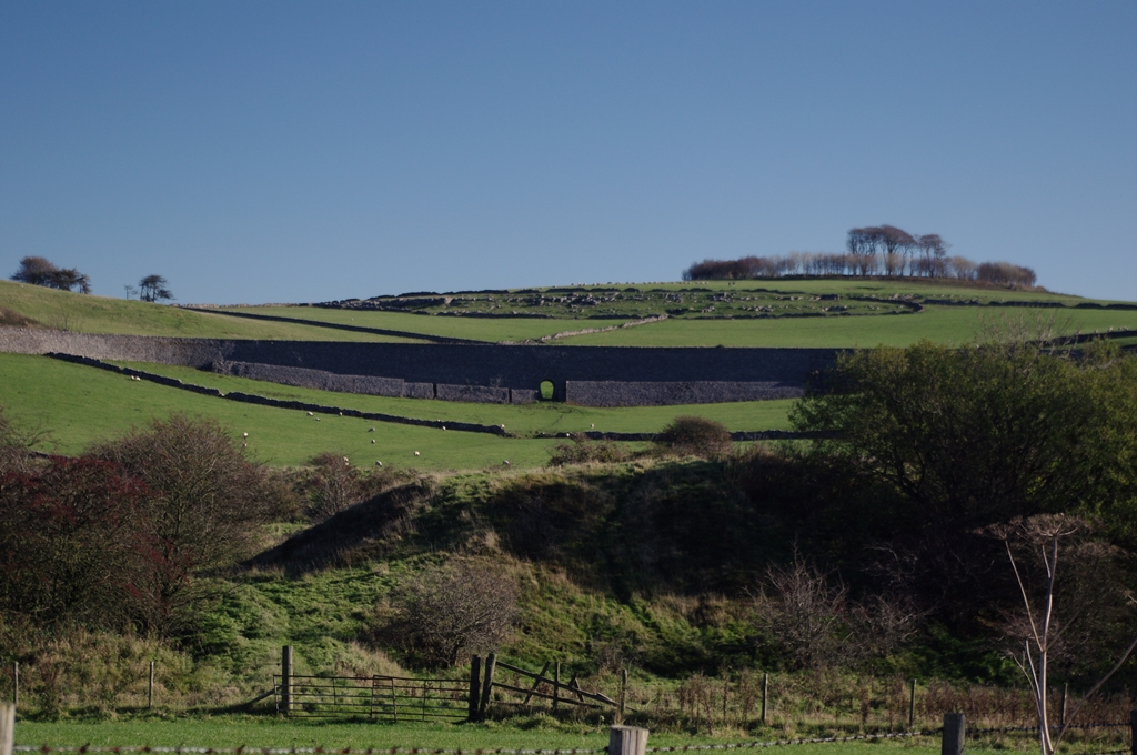
The view back up to Minninglow from here provides a layer-cake scene through the historical use of this landscape. On the hill's summit the prehistoric burial site; below that the natural outcrops of limestone (which provided the slabs for those tombs); then stone walls dating back to the enclosure acts of the late eighteenth century; finally the magnificent railway embankment of 1831.
But what are these huge earthworks in the foreground all about? A clue lies in the track surface we have just walked over. You may have noticed that, unlike the rest of the route, it was very sandy back there. By a happy accident, a large pocket of very valuable silica sand was discovered just below the surface of the soil and right next to the railway line.
It is part of series of such deposits, stretching in a line between here and Brassington, to the south east. The silica deposits were laid down in the hollows of the limestone by some long vanished river, during the late Miocene Era - around 10 million years ago.
Silica sand is very heat resistant, so is used to make the bricks which line industrial furnaces. A Victorian brickworks was established right here. For a while, our little medieval lane would have been busy taking bricks up to the railway line for onward transport to Sheffield, with its burgeoning metal industries. So besides being a valuable link across the White Peak, the railway encouraged the growth of industries, particularly those dealing with the local minerals.
There is still a firm that works with silica sand nearby – Hoben – while two others, Viaton and Longcliffe quarry and process specialist limestones. All three operations are just a short distance further south and right next to the track. The deposits of sand here are all worked out and the trains long gone, so the Hoben works bring in raw materials from elsewhere - by road instead of by rail.
Right from the start, the railway’s canal-like design rendered it less and less efficient. Though steam locomotives ran within a just few years of the line's completion, they were much thirstier than horses. Limestone is a permeable rock, which means water easily drains through it. As a result this plateau contains no running streams, so to service the trains special tankers of water had to be transported up here from the Derwent Valley.
Add in coupling and uncoupling the fixed engines on the steeply inclined sections and using the line was hard, slow work. A prime candidate for the infamous ‘Beeching cuts’, the line finally closed in the late 1960s.
The railways' loss was the walkers’ and cyclists’ gain. Today it makes for a truly fascinating tour, twisting like water this way and that, through an impressive landscape and thousands of years of history.
To return to the start of the route, continue along the lane. It becomes tarmac as a small road joins from the left. Follow the lane all the way to a crossroads. Turn right onto this minor road, alongside a belt of mature trees, back to the car park on the High Peak Trail.
Your browser is out of date, and unsupported by this website. Please upgrade to the latest version to use this website.
A short walk exploring the story of the High Peak Trail
The Peak District abounds with former railways now converted into scenic walking and cycling trails. The former Cromford and High Peak Railway, now the High Peak Trail, is one of the best.
But what led anyone to attempt such a difficult feat of construction, over a thousand feet above sea level?
This trail explores the reasons and uncovers signs of other transport routes over the White Peak plateau.
Follow the trail by clicking on the map pins or downloading the guide below
Simon Corble for creating and photographing the trail. Simon, a theatre director, playwright and actor based in Derbyshire's Peak District, is passionate about the countryside and discovering the hidden secrets of the natural world.
Ben Brooksbank and David A Hull for photographs reproduced under Creative Commons Licenses
 It is mind-boggling to think that this great mass of rock was formed from the remains of tiny sea creatures, which lived in a tropical sea here around 340 million years ago.
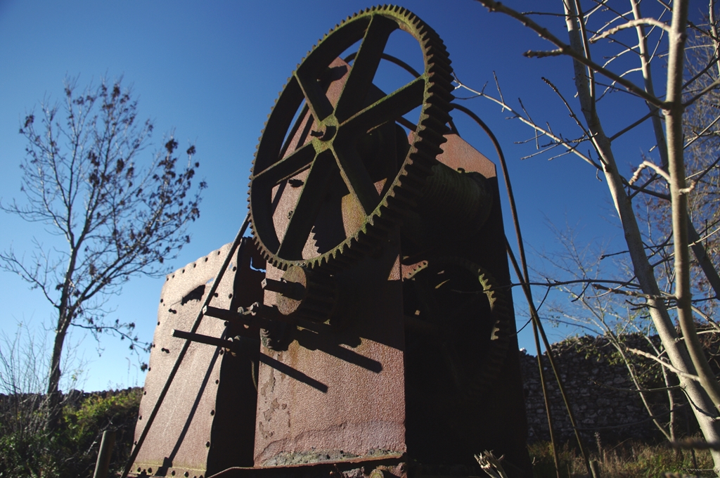
 This is a typical Peak District scene. If you follow the High Peak Trail all the way to its northern end, just outside Buxton you will run into some truly vast quarries still in operation. They load directly onto a dedicated ‘mineral line’, just as happened here. Such railways are a much greener option than road transport.
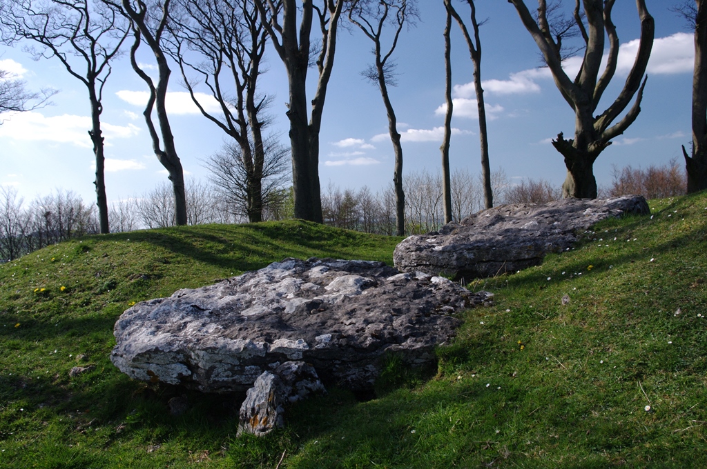
 Add in coupling and uncoupling the fixed engines on the steeply inclined sections and using the line was hard, slow work. A prime candidate for the infamous ‘Beeching cuts’, the line finally closed in the late 1960s.