Our trail begins with our back to the main road. To our left along the high street is the row of shops that epitomise Matlock Bath’s tourism today. Look ahead towards the river and its banks and we can find out how Matlock’s visitor appeal all began.
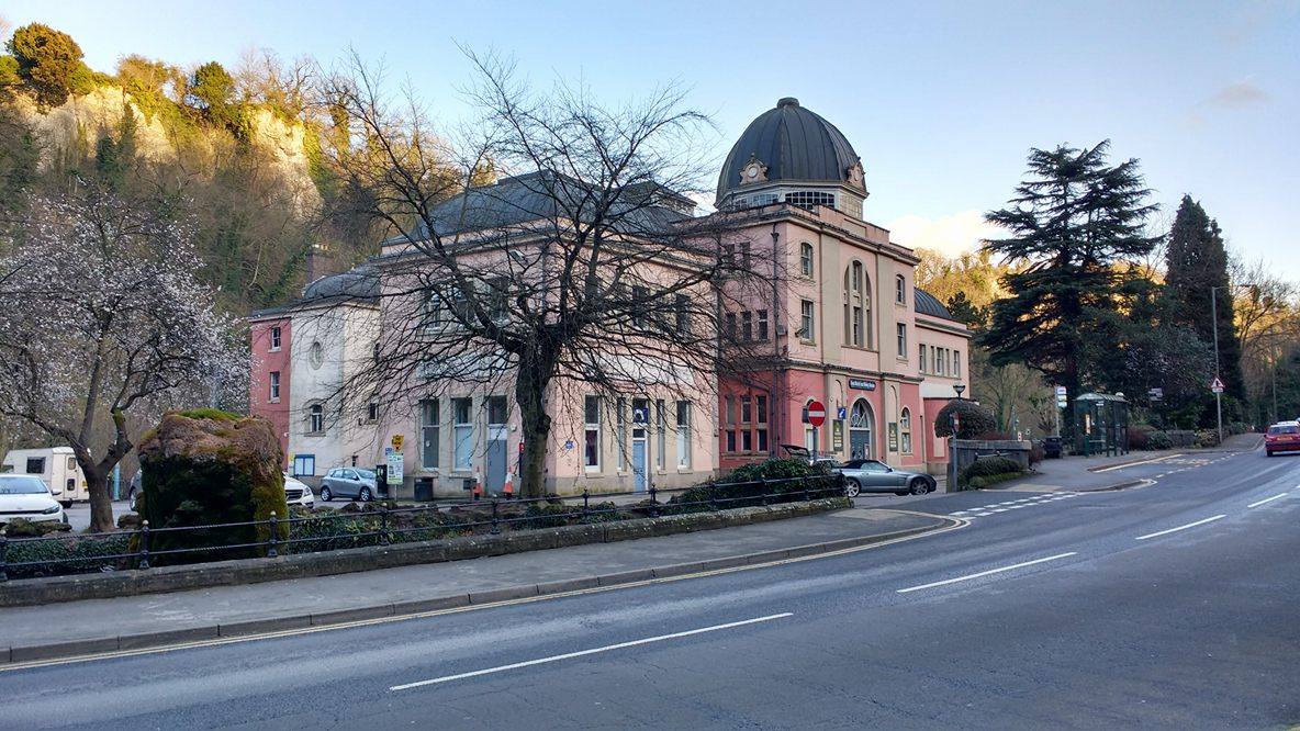
You can’t miss the pink tones and dome of the ‘Grand’ Pavilion. The building seems at odds with the natural backdrop behind it but the two are actually closely related. The Grand Pavilion once stood proud among hundreds of bustling day trippers, searching for shelter and entertainment. But what brought them all here?
Built in 1905 by a team of German contractors, the Pavilion was originally called The Kursaal, a German name which literally means the ‘cure room’. This translation is a hint, but venture behind the Pavilion and the full picture begins to emerge…
Follow the gardens round to the right, along the waterfront. At the far end of Derwent Gardens are shimmering springs and trickles of water. Look closer and you will see steam rising from the pools. Dip your hands into them to feel the water. Why is it so warm?
Matlock Bath shot to fame as far back as the 1600s when the first thermal springs were discovered here. Thermal springs occur when water emerges above ground from very deep inside the Earth. The Earth is much hotter towards its centre, or ‘core’. Water that is especially close to the core can be heated ‘geothermally’ – by the heat held inside the Earth itself. Such water is so hot when it starts its journey that even by the time it bubbles to the surface, as it does here, it is still about 20 degrees Celsius – the perfect temperature for a dip!
It didn’t take long before Matlock’s warm waters were reputed to have medicinal qualities. The upper classes came from miles around to bathe and cure their ills. The springs here at Derwent Gardens were among the first discovered. From 1698 they serviced the aptly named Old Bath Hotel and so began Matlock Bath’s heyday as a genteel spa resort.
This explains how Matlock Bath got its ‘Bath’. But how did so many visitors manage to find their way into this steep-sided and precarious location?
Directions
Make your way back through Derwent Gardens until you reach the white and green bridge. Cross the bridge and look back over the river from the opposite bank.
2 The River Derwent
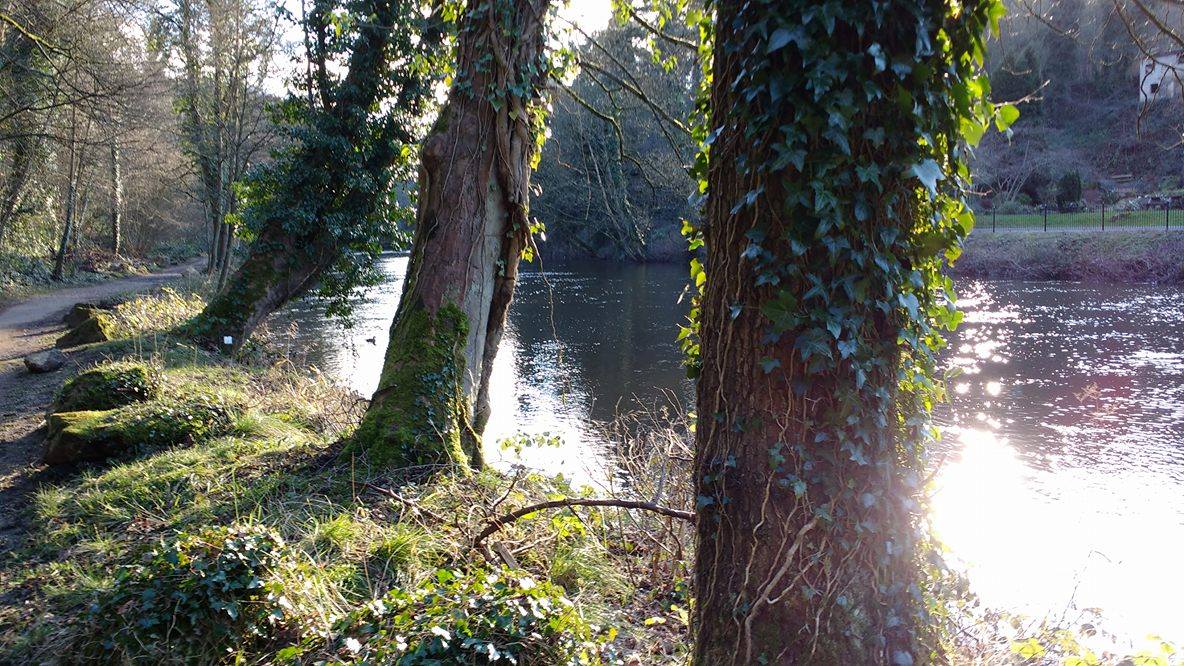
From on the other side of its banks, we can take in the beauty of the River Derwent itself. This river also formed the Matlock Gorge.
The cliff faces we can see are made of hard limestone but above them would have been layers of softer rocks – shales and grits. Over time the river water cut through these softer stones in a process called erosion and created the deep valley. Erosion is ongoing and now the water is slowly cutting through the much harder layer of limestone.
The gorge we can see, however, follows a curious route. Instead of eroding through the hard limestone, it makes more sense for the river to find other softer stones to pass through. At some point the river must have changed course. One explanation is that the river’s course was affected during the last Ice Age. Large glaciers may have blocked its path or forced the river to move by slowly pushing it from the east. Whatever the cause, it left a dramatically deep gorge and plunging limestone cliff faces.
One more change to the river’s course dramatically shifted Matlock Bath’s fortunes. Downriver (to your left) you could follow the Derwent on to Cromford. This small town just a mile away was where engineer Richard Arkwright harnessed the force of the Derwent to power his textile mills. Then in 1818 the gorge was forcibly opened further to create a toll road. This road connected the Derwent Valley with Nottingham (25 miles away).
This benefited the water-powered textile mills that pepper the river banks for miles around. It also increased access to Matlock and boosted tourism. Though the power of the river carved the gorge itself, people stepped in to complete the route that enabled Matlock Bath to become a bustling tourist destination.
Directions
Follow the tarmac path downriver until you reach a small steep trail leading up the gorge on your left. Stick to the path and follow it up the side of the gorge back in the direction of Matlock Bath - be careful as the path can be slippery and muddy after rain. Stop when you reach the black railings overlooking the river. Turn around to face High Tor, a rocky outcrop high above the valley behind you.
3 View of High Tor
Catch your breath at this vantage point. From here we can appreciate the natural beauty and grandeur of the landscape that the Derwent has carved out.
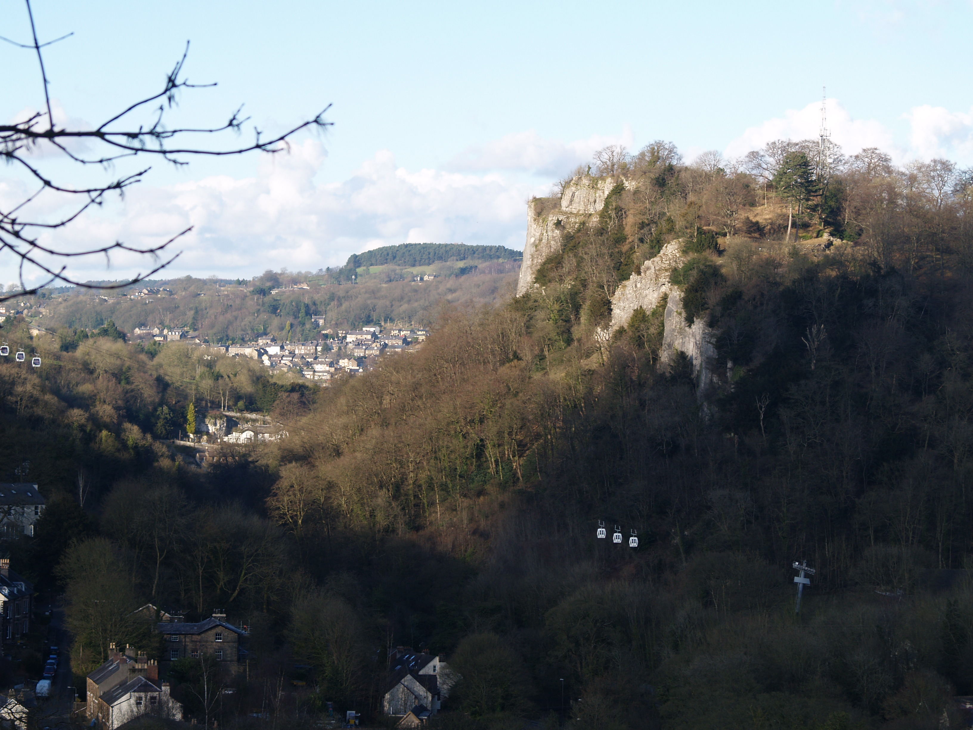
With your back to the street below, face the aptly named High Tor. A ‘tor’ is a large, free-standing rock outcrop that rises abruptly from its surroundings, which this one looming over us certainly does!
In its Victorian heyday, Matlock Bath and its neighbouring countryside were often referred to as ‘Little Switzerland’. From here we can get a sense of why, not least because of the climb up! The scene has inspired many writers and artists. In Mary Shelley’s Gothic novel Frankenstein (written in 1818, the same year the toll road opened) the narrator describes a visit: "We ... proceeded to Matlock... The country in the neighbourhood of this village resembles Switzerland; but everything is on a lower scale”. A century earlier, Daniel Defoe had recorded “the prodigious height of this tor…was to me more a wonder than any of the rest in the Peak”.
Looking around and breathing in the view, how does this scenery make you feel?
Look closely at the tor and you may catch a glimpse of three white carriages silently making their way up the valley. Let’s discover where the cable car leads and why…
Directions
Turn to face the other direction from the Tor - overlooking the river and the town.
4 View of Matlock Bath and Gullivers Kingdom
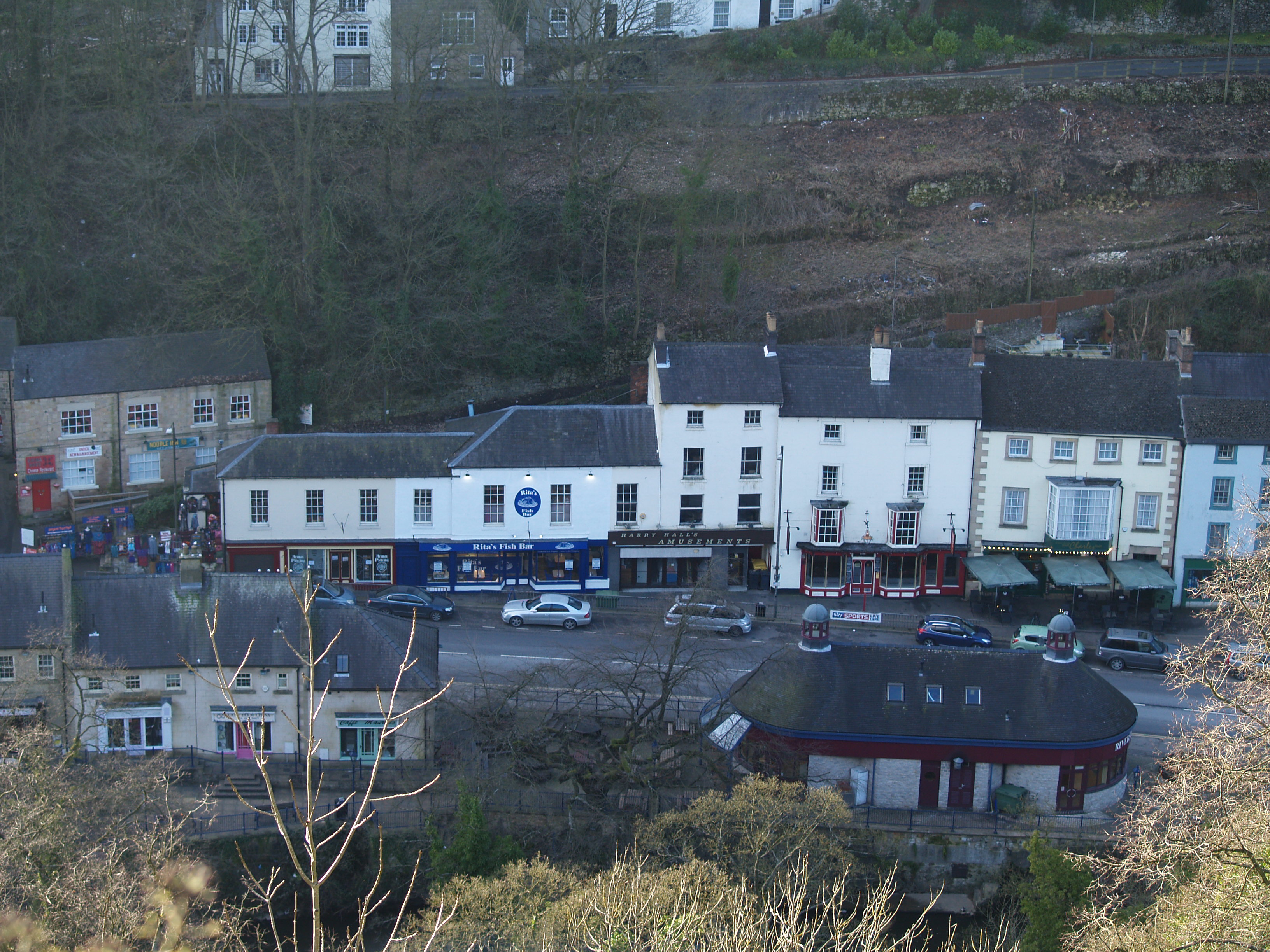
Turn your gaze back over the river to the town itself. See if you can make out the row of shops and amusement arcades below, and the glare of the theme park towering high up on the opposite side of the gorge. You might even catch the smell of fish and chips wafting its way up the cliffs!
We have explored how the road to Nottingham opened up access to the village, but how did this change an aristocratic spa town into the one we see below us today?
In early the 18th century, Britain was in conflict with France. The resulting Napoleonic Wars made travel across Europe unsafe and discouraged the wealthy from taking continental holidays (known as ‘the Grand Tour’). Instead British travellers were diverted to places much closer to home. Dramatic British landscapes - such as the Peak District and Lake District - became very popular tourist destinations.
30 years after the toll road, Matlock Bath saw the arrival of the railway. With thie trains came a completely different kind of visitor. The large, organised excursion had arrived!
Matlock Bath was now even more accessible from newly industrialised Derby and Nottingham. Location and access meant Matlock was then not only a spa destination but a perfect getaway for land-locked city dwellers. With the nearest coastline nearly 100 miles away, Matlock Bath took on the role of a traditional seaside resort. As the new middle classes came to see the sights, the village’s aristocratic ambience gradually gave way to commercialism. At the peak of the Pavilion’s popularity in the early 1900s Matlock’s station saw 17 trains arrive per day.
Mass tourism here still scales new heights – literally! The cable cars we spotted earlier transport visitors to another Victorian spectacle, The Heights of Abraham. These are a set of caves, which formed both naturally and from mining. In the early 20th century they were turned into show caves, complete with light displays for the increasing numbers of day trippers.
Tourism, however, also grew in an era of fascination with the natural world. The wilderness and dramatic landscape of the gorge itself also made it a visitor destination in its own right.
Directions
Continue on the higher level of the walkway with the town below you. You will reach a wooden fenced path that leads back down the hill, but take the right fork to continue along the top with the town on your left. At the second fork do the same out into more open countryside – there is a ‘Lover’s Walk’ sign post on this fork.
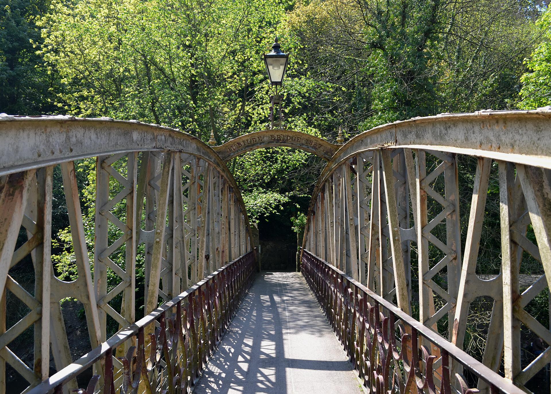
Follow this route past the sign post until you have wound down the hillside to reach the Matlock Bath station car park. Turn left out of the car park over the small bridge that leads you onto North Parade. Follow this along until you reach Jubilee Bridge on your left and cross over to the opposite bank to stand on the lower level of Lovers Walk.
5 Lovers' Walk
We are now in the Lovers’ Walks, a series of paths that lead visitors through the gorge. On this side of the bank the paths tempt visitors along the river and up into precipitous gorge side above.
The Lovers’ Walks are believed to be the oldest surviving example of a public pleasure ground. They have been in continuous use since the 1740s and have enabled generations of visitors to follow the trends set by poets Shelley and Wordsworth, whose writings inspired respect for and wonder for the beauty of nature.
With the railway bringing increasing crowds, however, the Lovers’ Walks were hard pressed to cope with the rising numbers. Then in 1887 this tree-lined promenade and the bridge we have just crossed opened to coincide with Queen Victoria's Golden Jubilee.
Woodland still covers all but the Lovers' Walks paths. The trees here and those on the High Tor are classified as Ancient Woodland - a definition used to protect wooded areas that have been growing since 1600. They have also been designated as Sites of Special Scientific Interest by Natural England.
The Lovers’ Walks were one of the first examples of how Matlock Bath changed to cater for tourists, whilst preserving the natural features of the landscape.
These attractions retain prominence today and are a stark contrast to the brightly lit shop fronts along the main street. We will now explore these to discover the final mysteries of Matlock’s curious mix of natural grandeur and seaside-style entertainment.
Directions
Cross back over the bridge and almost directly in front of you will see the bright blue exterior of the Matlock Bath Aquarium. Cross over the road and stand outside it for our final stop.
6 The Aquarium
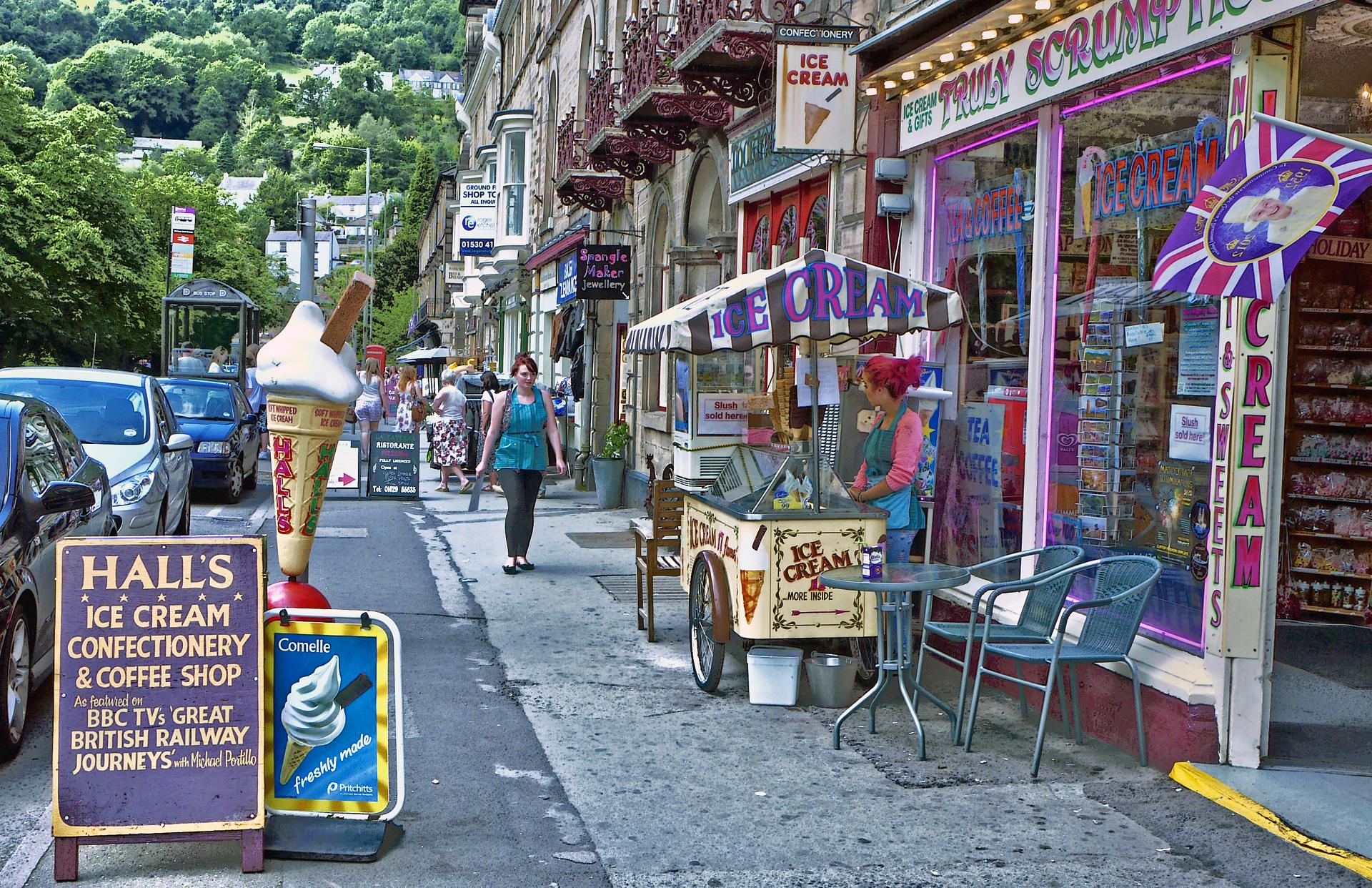
Standing on the main street, look along the line of shops, arcades and attractions. The tranquillity of our view from High Tor above may seem like a lifetime ago!
Imagine the hustle and bustle of this main thoroughfare when the railways first ferried visitors in droves. The sights prompted J. B. Firth in 1908 to describe "the bawling of the drivers of brakes and waggonettes, the attentions of the pushing salesmen".
Today the bold blues, yellows and pinks of ice cream shops, fish and chip bars and arcades are hard to miss. And neither is the Aquarium. This building holds another clue to Matlock’s visitor appeal. Of the many spas and wells that first brought visitors to Matlock in their thousands, behind these walls is the only one that still works today – the Petrifying Well.
A ‘Petrifying Well’, as advertised on the board outside, was a real feature of the town that drew in crowds of thrill seekers from the surrounding cities. But what is a ‘Petrifying Well’?
The answer again points to how Matlock Bath gorge was originally formed. The high mineral content of the limestone cliffs gives the water a seemingly mystical quality. Limestone makes the water so rich in calcium and other minerals it appears to turn objects into stone!
What actually happens is that when the heavily mineralised water evaporates in the heat of the thermal springs, this leaves a deposit of calcium carbonate and lime salts. These build up on objects left in the water and their exteriors become ‘solid’. The process is similar to the way stalactites and stalagmites - the icicle-like columns inside caves - are created.
This curio, once a pillar of Matlock Bath’s development, is now bolstered with an aquarium and fossil collection. Both are further examples of the village’s continuing seaside aroma.
Though we are back on the main street, our trail has taken in riverbanks, cliff top walkways and cable cars. Our journey has uncovered the ways Matlock’s natural landscape and human intervention have combined to create a one-off destination. Although we are 100 miles from the sea, we explored the unique set of circumstances that give Matlock a coastal resort feel - from the types of rocks in the gorge to its ideal location for Victorian holiday makers in the East Midlands.
Maybe Matlock Bath has the perfect combination of factors to sustain this unusual but undoubtedly popular tourism for many years to come?
Directions
Continue on down North Parade until you return to the start point at the Grand Pavillion on your left.
Your browser is out of date, and unsupported by this website. Please upgrade to the latest version to use this website.
A short walk exploring Britain's most dramatic spa town
The village of Matlock Bath nestles by the Derwent Valley, a steep riverside gorge in the Derbyshire Peak District.
Winding through its towering cliffs and taking in incredible views, there’s no hint of seashore waves. But there is a very strong feeling you are in a coastal resort.
Matlock Bath is nearly 100 miles from the sea yet is lined with holiday makers, amusement arcades and fish and chip shops. This trail explores how Matlock Bath was formed and how its unique style of tourism developed.
Follow the trail by clicking on the map pins or downloading the guide below

.jpg "Matlock Bath Aquarium")
