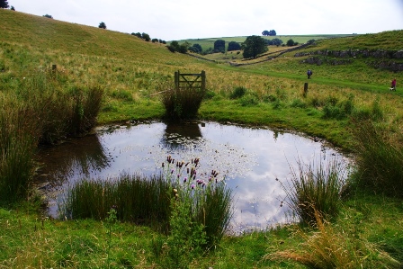
The fencing is somewhat ironic, as this old dew pond was put here in the first place to provide water for farm animals. But why go to the bother, (and it must have taken some real hard graft) of constructing a pond at all? We are in a dale so you would expect to find a stream at least, but there’s no evidence of it here. The answer is down to the underlying rock. The limestone plateau all around us is extremely porous; any rain that falls quickly disappears underground to emerge, as we shall see, much later in our journey.
These days, mains water is piped to modern water troughs and old dew ponds are instead preserved as a haven for wildlife. It is well worth standing here awhile, to see what creatures may be active in or above the water, including many different species of dragonfly, water boatmen, at least two species of newt and some terrifyingly enormous horse leeches. A teeming oasis. Time also to ponder that Monyash's five natural meres, sitting in thick pockets of impervious clay, would have been an extremely rare and valuable resource to ancient peoples in a dry landscape; a good, and no doubt sacred place to site a village.
Directions
Continue along the grassy path, taking advantage as you do of the Natural England information boards. Just through the third gate there is a junction of many ways;our path takes us straight down the main course of the dale and through the final gate; continue for about another 150 metres.
2 A Narrow Passage
Suddenly the open dale is left behind and smooth limestone cliffs close in on both sides. At its narrowest point, this passage is no more than ten metres broad. It is almost claustrophobic. No water ever flows here these days, not even after the heaviest rainfall. Take a closer look at those rock faces either side of you; surely, they must have been sculpted by a flow of water on a biblical scale.
It is quiet here today – maybe all you can hear are the songs of redstarts and willow warblers in the thorn trees above? Yet all about us is clear evidence of what must have been a thunderous process; to the left of the path there is an overhang of rock, this is where an ancient river has undercut into the rock-face and, looking up, do you think that there was once a complete roof above?? If so, at some point it must have collapsed, the debris washed away in the powerful torrent.
All of this tumult happened around ten thousand years ago at the end of our most recent Ice Age. A layer of thick ice covered northern Britain but as temperatures warmed and we entered a major melting phase, the retreating ice sheet produced unimaginable quantities of meltwater. Both the ice sheet and its meltwater carved out the steep valleys and rocky landscape we associate with the White Peak.
The same retreating ice left Monyash with a valuable gift, a thick deposit of clay in its hollows. Clay-lined hollows would hold water for wild animals to drink from, perhaps even as the first intrepid human hunters appeared on the scene.
Directions
Continue down-dale. The next part is the trickiest to negotiate, as the way is strewn with huge boulders, some of which have to be half clambered over. Stop at the stile by the large sycamore.
3 Sycamore tree
The large boulders just behind us are the spoil from a long disused quarry in Ricklow Dale above.. The quarry produced a highly prized form of limestone, known as black marble, full of interesting fossils. Visit the Bull's Head in Monyash to see a fine example serving as the pub's threshold.
If dry, this moss-covered sycamore tree is a fun and easy climb for children, or the young at heart, but its deep roots must be tapping water from somewhere below... Looking over the gap and stile in the dry-stone wall, the dale starts to open out once more, revealing lofty heights on either side, wheeling with jackdaws chattering overhead. These and other birds such as peregrine falcons and ravens, find attractive nest holes and ledges in the eroding crags.
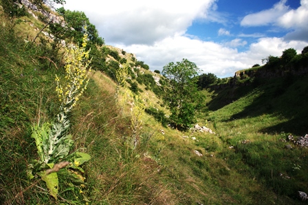
Gazing up you will see a host of inaccessible stacks and small caves formed thousands of years ago by smaller torrents of meltwater. The nationally rare blue-flowering Jacob's Ladder grows in the grass on the north-facing slope in the fenced area to the right, while in high summer the path ahead is dominated by the tall yellow spikes of Hoary Mullein. This impressive giant thrives here in the dry and sun-parched soil, many miles from its East Anglian stronghold.
On a sunny day, the dale can feel like an oven from this point on, the pale limestone reflecting heat from all angles. Hats are a real necessity and make sure you have plenty of water with you. Amazingly we have not yet encountered any natural water sources in the dale but perhaps there is the very distant sound of something further along the path? Hop over the stile and let's continue to investigate.
Directions
Continue down the dale.
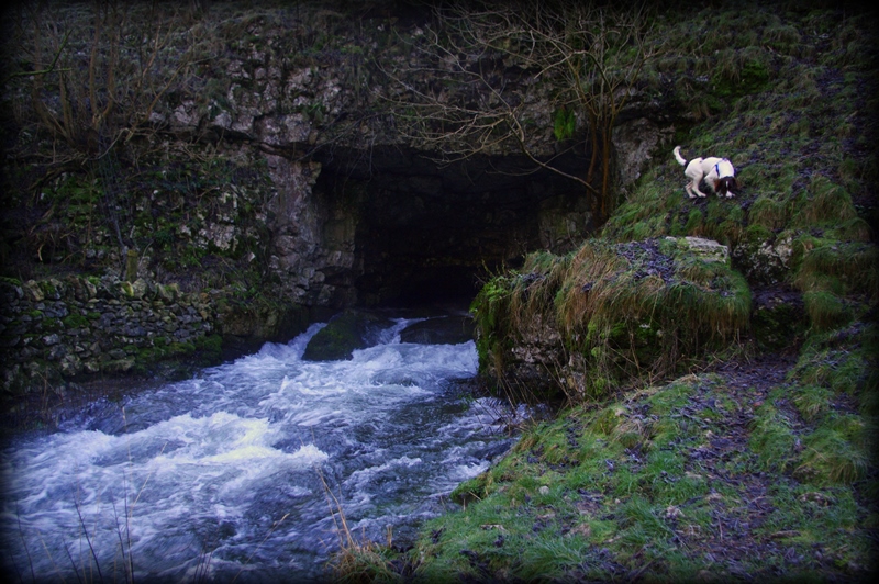
4 Head Cave
You cannot fail to miss the large cave on your right. In winter, or sometimes in a very wet summer, the River Lathkill emerges here, from its source at Head Cave. It can be a dramatic sight. If it is in spate, explore very slowly along the river bank, and listen for the thrilling changes in pitch made by the tumbling water. The topscale tinkles are supported by some powerfully deep bass notes – clues there must be some large and resonant hollows hidden just beneath the stony riverbed.
We are around one hundred metres below the level of Monyash's meres and yet the likelihood is that this river bed is dry. Any water that is flowing here may have fallen as rain a few days ago, as far away as the village of Flagg, some three miles away. Some of the subterranean channels transporting the water between Flagg and here are explored by cavers; don't be surprised to meet a few squeezing their way out from the shadows at the back of the cave.
Just a few metres past Head Cave, a short arm of the dale can be seen to the left, and, at its head, a relict waterfall. The tributary river may have stopped flowing there when the last of the ice sheets had vanished, but impressive icicles still sometimes form on its overhangs in winter, as melting snow drips onto the cold rock from the grassy slopes above.
Directions
Continue down the dale until you reach a wooden bridge.
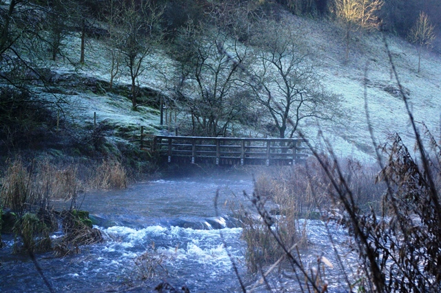
5 Sheepwash Bridge
As its name suggests, the bridge spans a pool once used by local farmers to wash their sheep's fleeces. Now it is a haven for ducks, water voles, dippers, grey wagtails and many other birds which come to drink among the boulders and aquatic plants like meadowsweet, watercress and watermint. A bubbling and vibrant reminder of how precious water is to all forms of life.
In very dry years, the water is absent even at this point and young fish have to be rescued and moved further downstream. Some of this is due to centuries-old mine workings, the drains from which have deprived the Lathkill River of much of its former flow. Plans are now in place to block the biggest of these drains, to the great benefit of all this local wildlife.
Directions
Our walk now takes us over the bridge and into Cales Dale. After winding among thorns, hazels and past a small spring, (below and to the left of the path in wet seasons), keep right to climb a short way up to a dramatic face of river-eroded limestone, where ivy hangs in profusion. The path continues a short way along a ledge at the base of this cliff and then up a narrow staircase of steps cut into the rock. Just past the ancient mine entrance to the left, the path emerges from the woodland into open fields, via a small gate. Up the hill and a short flight of concrete steps is the fascinating farmyard of One Ash Grange.
6 One Ash Grange
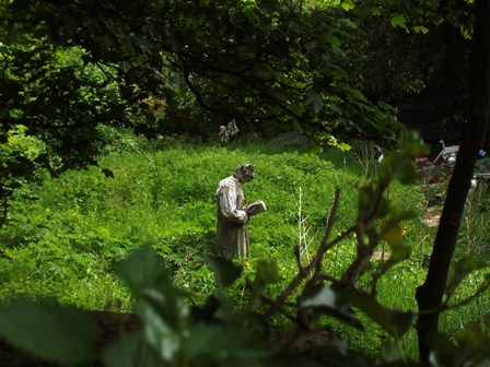
This is a spot to soak up a real sense of history. Semi-derelict buildings abound, many dating back to the twelfth century when this was a farm worked by monks from Roche Abbey in South Yorkshire.
Tradition has it that brothers who had misbehaved were sent here to do penance. The life-size, but contemporary, stone statue of a Buddhist monk in the farmhouse garden is a reminder of those former days, as is the medieval ice-house (a small, adapted cave to the right) and the old run of stone pigsties, with their clever system of feed chutes and troughs. Ice may have been collected by the monks from the Lathkill River during the winter and used to help keep dairy produce cool and fresh.
But what of the monks own need for water? Either a well would have been a necessity here, sunk deep enough to reach the natural water table, or water may have been collected from the spring some way back in Cales Dale. It is not too difficult to imagine the monks carrying buckets of water, or ice, toiling up and down that slippery stone stairway we climbed a short while ago, perhaps cursing the day they were sent here.
This is the last stop on our trail. Your walk may be over, but if you have time it is well worth exploring the village of ‘many waters’, Monyash, with its natural mere and fine old buildings – not forgetting The Bull's Head. The pub has been on The Green since the Middle Ages when it no doubt set up to serve the thirsty traders at the weekly market. A ‘watering hole’ for humans alongside a whole complex of others for the animals that were being bought and sold. Quenching your own thirst there, perhaps you will really appreciate the value of this little oasis on a dry, limestone plateau.
Directions
From the pigsties, twisting left and then right through the farmyard, we climb upwards again, along a stony track. Through the metal gate at the end of the track, (having ignored the track joining from the left) there is a splitting of ways. Take the public footpath on your right. Go past a midden, just to the right of the path and through a series of sheep pastures, swinging slowly left for an easy descent on the now grassy way to the bottom of Lathkill Dale. Simply head back along the path, climbing very gradually up the dale, to reach the start once more, through that succession of wooden gates.
Your browser is out of date, and unsupported by this website. Please upgrade to the latest version to use this website.
Lathkill Dale has its beginnings behind Monyash village, around three hundred metres above sea level. The name Monyash is thought to come from the Anglo-Saxon many and the Celtic word aesc meaning waters.
There is only one big mere (shallow lake) left in the village today, but there were five until they were filled in quite recently to provide the village with local amenities.
The five ponds must have been vital during the sixth century AD, when the Angles were starting to arrive, settle and learn about the area from the native British.
But why were these natural ponds so important? A walk down the upper half of Lathkill Dale reveals the full story of a landscape shaped and governed by the presence, or absence of water.
Follow the trail by clicking on the map pins or downloading the guide below
Simon Corble for creating and photographing the trail. Simon, a theatre director, playwright and actor based in Derbyshire's Peak District, is passionate about the countryside and discovering the hidden secrets of the natural world.
 rs.jpg)