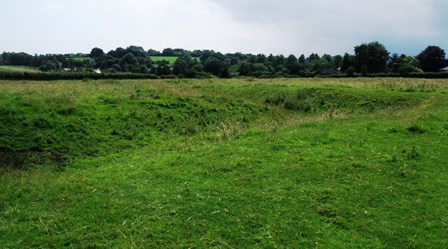
Amongst the rough grass at the southern end of the field you might be able to make out shallow ditches that define old field and property boundaries of the medieval village.
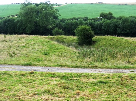
Further north and to the left of the footpath, is a short section of ridge and furrow, the name given to the corrugated earthworks formed by the oxen-drawn ploughs of the medieval farmers. These faint remains can be pretty hard to spot if the sun isn’t low enough, but you cannot miss the two metre deep dry moat surrounding a 3200 square metre L-shaped platform to the east.
Typically moats were dug to compliment wealthy residences of the gentry or monastic farms, enclosing the main house and its buildings (such as kitchens, barns, even chapels). In many cases all that survives today is the remains of the moat and only research and excavation could confirm what was inside. For a long time it was thought that moats were built purely to defend these estates, but more detailed consideration suggests the moat builders had other motivations.
Can you see another wide channel running parallel to the north side of the moat and a smaller one extending south? These suggest that this moat doubled up as a fishpond; the extra channels helping to manage the fish stocks. The northern channel may have been where they bred the fish until large enough to release into the moat.
Fishponds were a common feature of the medieval landscape and if you find evidence of them then it is often a clue to the age of the village. They reached a height of popularity in the 12th century.
Fish was an important source of protein in the medieval diet, particularly in winter and during religious festivals, such as Lent, when traditional forms of meat were forbidden. Farming fish in this way required land, stocking and management. It was, therefore, something of a status food (think of lobster, oysters and caviar today) and was the preserve of the aristocracy and the church. Eel, tench, pickerel and bream were popular breeds, so the people who lived here were probably quite wealthy and had a varied diet.
Just to the north of the moat can you see a wide low bank running roughly east-west? Believe it or not this is the remains of a Roman Road. It was built to connect the Roman settlement and fortress at Lincoln with the coast. The route of the road leaves Lincoln towards Wragby, where it forks and runs as the crow flies for 15 miles southeast to this section at Brinkhill. From here it kinks further south and can be traced as far as Burgh le Marsh, 9 miles away.
The Lincolnshire coast looked very different then. At the eastern end of the road was a peninsula and a major Roman settlement, probably a port. The road allowed for easy transit of goods to and from Lincoln and through the many settlements on the way.
Directions
The footpath leads up the western side of the moat to the stile. Over the stile the trail hugs the edge of the woodland and then turns north along the hedge line to the fingerpost at the corner of the field. Follow the path through the next arable field toward the bridge on the far side. You will have Furze Close on your right. Over the bridge head straight across the pasture field to the next field boundary.
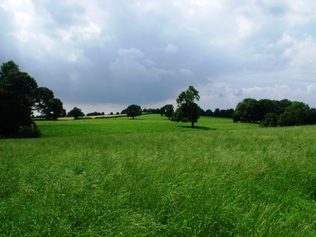
2 Field boundary/valley view
Just take a moment to catch your breath at the top of the stream valley. From here you can look back toward Brinkhill and the surrounding chalk capped hills. The chalk rock was laid down in warm seas about 90 million years ago and is the youngest of the rock formations in the Lincolnshire Wolds. It overlies a sequence of earlier clays and sandstones dating back 150 million years.
The soil under Brinkhill is impermeable clay and holds water better than the surrounding chalk which being porous allows water to drain through. Maintaining high water levels here was easier than in other areas and is perhaps one of the reasons we find so many moated sites here.
To the right is an expanse of pasture where solitary mature trees mark the lines of ancient field boundaries. In the closest corner of this field and if the sun is low enough, you might be able to make out the wavy earthworks of more medieval ridge and furrow.
In the medieval period each peasant’s land holding was divided into lands or strips. These strips were scattered throughout the fields of the parish so that good and bad soil was equally shared. It would be awkward for each person to work individually so the fields were farmed communally, each person collecting their share of a field’s crop. Each strip was ploughed separately by a team of oxen, turning at the end of each strip in the same direction each time (usually clockwise) causing the soil to ridge in the centre and creating furrows either side. It is these strips that you can see fossilised as earthworks where the land has not been ploughed since.
Beyond lies Redhill, named after the red chalk that caps the summit. Before the end of the last glaciation, about 12,000 years ago, thick sheets of ice covered much of the Wolds. The ice and meltwater eroded valleys through the layers of rock. The youngest and uppermost rock formations, such as the red chalk, survive at the top of these valleys. It is the presence of iron oxide that gives the red chalk its rust-like colour.
Directions
Head east down toward Furze Closes, through the gate and into the woodland.
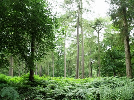
3 Furze Closes
From the tinkling of the Calceby Beck that runs through the culvert at the edge of the plantation, to the cries of the buzzards circling overhead, the woodland fills the senses. The rustling of the distant canopy seems to add to the tranquillity and on a hot day the trees will afford some much welcome shade.
Furze Closes is not an ancient woodland, but was established before the 1880s. The name Furze refers to the low growing spiky gorse plant - not much in evidence today – not to the fir trees that share the plantation with deciduous varieties, notably beech.
Directions
Keeping strictly to the path indicated by the signs, you will pass over a stream. When the trail emerges onto a track, turn right and you will see your trail disappears into the trees past a short section of fence. It emerges from the wood about a hundred metres further on and leads across an arable field toward a square brick building. Hug the fence past the waterworks and then cross the stile and up to the road. Continue up to the next stile over the fence to the left.
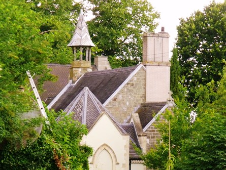
4 St Michael's Church
If you look to the right, above the hedge, you will see the roof of a church, now a private house. Human bones have been unearthed here at various times during the conversion of the building – would that make it an exciting or a creepy place to live?!
You might be wondering why a church was built here in this lonely spot. The church once stood at the heart of the bustling medieval village of Driby. But look around. Where has the village gone? The answer is that its remains are all around you abandoned and eroded by time. Keep your eyes open and you’ll see what’s left of it before you leave.
The pasture on your left contains a large moat–like hollow stretching off toward the wood. It is very wide and has been quarried for building clay at several places, giving it an irregular appearance. This hollow might be a couple of things. It could be a sunken medieval road known as a holloway - leading up to the deserted village of Calceby.
Alternatively, part of it at least may represent the ditch of an old park boundary that once encircled Driby Wood and the area of the current Driby Manor. Its line can be traced on old maps and probably encompassed about 70 acres of land. These boundaries are also known as pales and usually combine a fence/wall with an internal ditch. They were essentially enclosed areas of pasture and woodland to manage game and livestock. The park may have been conceived in the Middle Ages when many members of the minor nobility created parks on their estates. Rather like moats they were less about defence and more about fashion - another outward symbol of status.
Directions
Continue along the road, across the cattle grid, past the agricultural buildings and Driby Manor and ménage.
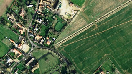
5 Driby manor
In the medieval period swathes of land were granted by the king to his lords in return for their service. These estates were known as manors and the term has traditionally become tied to the house the lord built within those lands. Here Driby Manor is the large double gabled farmhouse you can see to the north.
Manor houses were often surrounded by a moat and to the east of Driby Manor you can see a large hollow described on maps as a moat. It has also been suggested that there is another moat lying tight up around the northern side of the farmhouse. However, there is no proof of either. The smaller moat may simply be evidence of quarrying. The large one is more likely to be a holloway or old road through the old village, worn down by vehicles and footfall as the villagers moved produce and livestock.
With your eye, follow its line south, across the manor’s drive, across the road and south into the grass field on the other side. Now see if you can find the main street which intersects it, leading off into the village remains in the field to the east. It continues to head south to disappear before the field edge. This could well have been the line of the original right of way.
Directions
Bear right off the road into the bumpy field and head over to the wooden post and rail fence at the end of the trees.
6 Driby deserted medieval village
If you know where and how to look this large field on the other side of the fence contains the most visible clues to the lost medieval village of Driby. See if you can spot the main street as it continues directly up the middle of the field. On either side of the holloway look for raised platforms and ditches which mark out the old house plots. These ditches though are not more moats, they are the land allotted to the villagers for their houses and smallholdings gardens if you will - where they might have kept livestock, grew vegetables and had their privy.
Driby was mentioned in the Domesday Survey of AD 1086 and was owned by Gilbert de Ghent. It suffered a similar fate to many of the Domesday villages in the Wolds, shrinking or being abandoned completely.In the fifteenth and sixteenth centuries a change from arable to livestock farming saw the abandonment of many villages as fewer workers were required.
This was the culmination of a period of famine, brought on by a deteriorating climate, and plagues that reduced the population and made labour more expensive. Some medieval villages were deserted completely and only the earthworks of their former roads and properties remain. Here at Driby just a few families endured, working on the estate while nature reclaimed the abandoned buildings.
Directions
Head back west along the southern edge of the field and turn left onto the track leading south back toward Brinkhill. At the head of the track, turn right to follow the field edge. Follow the path until you have reached the far corner of the woodland and immediately after take the path to the right, cutting across the arable field (there is a footpath sign leading off to the right through a narrow gap in the hedge before you get to the woodland – don’t take that one!) At the top of the field you will cross a stream.
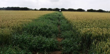
7 Old Roman Road
About a hundred metres after you cross the stream you will pass over the same Roman road you crossed in the first field. Can you see any sign of it as a raised strip of ground across your path, or perhaps in the way the crops are growing to either side?
As well as Roman and medieval remains there are prehistoric sites throughout this landscape. Some, like the one over on the hills to the east, were settlements, enclosed by ditches, much like the medieval moats. A string of burial mounds also overlooks Driby from the north. Their remains however have been obscured by hundreds of years of ploughing, which has also brought some artefacts to the surface.
As you walk through the arable fields you will see that the ground is littered with flint stones. Some of these, particularly if they are sharp, rippled or translucent, might have been Stone Age tools used by our ancestors 4000 years ago. Keep your eyes open!
Directions
Keep along the footpath, through the hedge and across the open field down toward Brinkhill.
8 Invisible moat
As you approach Brinkhill, beyond the hedge line to the right is a cluster of tall trees. Behind these lies the remains of another moat, a real one this time, though unfortunately hidden from view.
Like the moat we saw at the beginning of the walk, this was dug to surround a substantial house (perhaps even a manor house) which would have been owned by a medieval nobleman.
This moat is much smaller than the first one we saw at only 700 square metres and might have been built before the two larger ones. Or it may have been created by someone with a more modest income, with less land and money to build a really grand residence, but still wishing to show off. Was the moat the medieval equivalent of a double garage or electric gates?
As well as a sign of status (and perhaps a desire to keep up with the medieval Jones’) moats were a literal and symbolic means to separate oneself off from the peasants!
Directions
Emerge back onto the road at Brinkhill across a narrow beck.
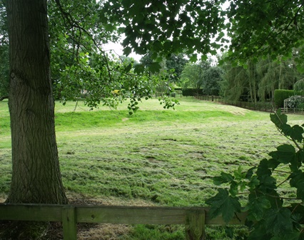
9 Manorial moat
Immediately on the other side of the road is our final moat, visible through the gaps in the hedge. As you can see the moat is quite wide, enclosing a raised rectangular area of about 2000 square metres. At the northeast end there is a raised platform where a house and its outbuildings might have stood.
Its size and proximity to the modern manor house (just 50m to the south), suggests that this may have been the site of the original manor, the Lord’s residence.
But why moats? Their popularity may have been in response to the grand castles and homes of the new Norman nobility which were built across the country in the decades after the Norman conquest in AD 1066. The moat perhaps became associated with high status and was aped by those wishing to present themselves as a member of the well-to-do of medieval society.
So it seems medieval moat construction might have been a fad, much like the contemporary practice of crenellation (fortifying your residence). That is not to say that moats – like crenellation - did not serve a defensive purpose; they certainly would have provided a deterrent against brigands or disgruntled peers, but unlike adding battlements to your house, moats did not require permission from a higher authority, so anyone with enough spare cash could do it.
Akin to headboppers, the Atkins Diet or reality television, there does appear to be a time in the Middle Ages when digging a large ditch around your house was the next big thing.
Directions
Turn right at the crossroads and carry on past the church to return to the start.
Your browser is out of date, and unsupported by this website. Please upgrade to the latest version to use this website.
Think of a moat and you’ll probably picture a deep watery ditch around a castle. There are over 6,000 moated sites in the UK - but at most of them there’s not a castle in sight.
Though we won’t find many castles, we will see evidence of many moats. They abound in the Lincolnshire lowlands where there are literally hundreds.
Some parishes have several - Frampton just south of Boston has seven, while here in Brinkhill there’s three. And in neighbouring Driby, even though it is hardly a village at all.
This trail explores this phenomenon and what it tells us about medieval trends.
Follow the trail by clicking on the map pins or downloading the guide below
St. Philip’s Church, South Ormsby Road, Brinkhill, LN11 8QY
Grid reference:
TF 37174 73512
Keep an eye out for:
Worked flint stones in the fields that might be relics of Stone Age tools
Directions to start:
From the church follow the South Ormsby Road north 100m to edge of village and track on your right. Go through the hedgerow via a stile into the large pasture field.