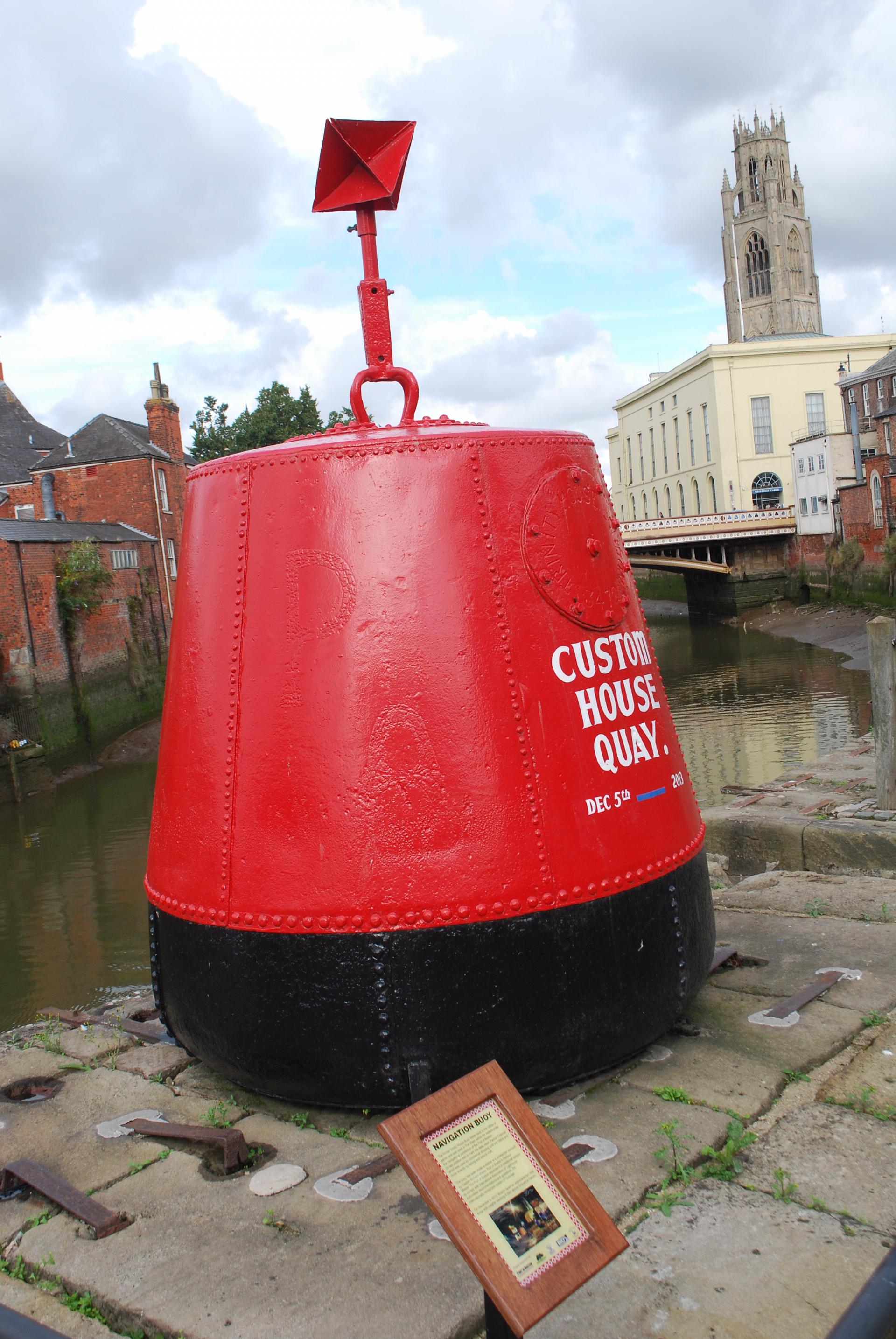
Stand by the red buoy and take in the slow curve of the river. It’s hard to believe that the quiet town of Boston was once one of England’s largest ports, second only to London in the late 1200s.
This area was once a hive of activity, a bustling harbour where boats were loaded and unloaded, alive to the sights, sounds and smells of imports of wine, leather and spices, and frantic with the loading of wool and salt exports.
Ships from Boston traded with other parts of the country and with foreign ports. It’s estimated that three million fleeces from Lincolnshire and Yorkshire were traded across Europe in the ten years between 1280 and 1290! One of the reasons for Boston’s success was that it also acted as the port for Lincoln thirty miles away, the biggest city in Lincolnshire and a major market.
In a time when it was difficult to get news of events beyond a few miles from home, Boston was in contact with the world and the town would have been alive with stories from foreign parts.
A little further downstream (to the left looking at the river) we can see some remains of this era of trading – the old sturdy brick warehouses, which have now been converted to homes and offices. Behind us, the red brick building on the corner of Custom House Lane is maybe unsurprisingly, the Customs House where import duties were paid.
Today the port of Boston still exists and thrives, although it no longer rivals London or the other dominant ports like Grimsby and Felixstowe!
But why the dramatic change to the small market town we see in front of us today?
Environmental and political changes were to have a profound impact on the future prominence of the town.
The geography of the area that once enabled Boston to flourish as a bustling port – its location along clear waterways linking the east coast to the rest of the Midlands, has over time caused its demise.
The channels feeding the River Witham had always been prone to silting, and sluices and drains added to this stretch of water in the 1700s didn’t manage to taper this process. With the connectivity of the town through national waterway networks compromised, its function as a port for luxury goods and spices went into an ongoing decline.
This physical change, along with political shifts such as the Hundred Years War rendering imports of wine from France redundant, meant Boston has had to recreate itself in a different guise.
The agricultural landscape that now dominates this region has shaped the future of the port. Large cargo ships now transport fertilisers and grains to Europe in just a few windows of high tide that enable large vessels into The Haven and River Witham.
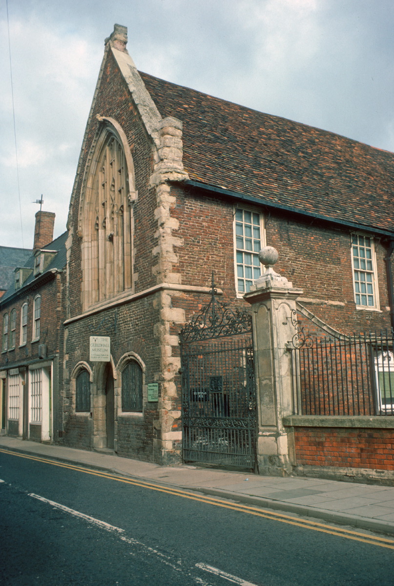
Continue along the street following the direction of the traffic and stop at the far side of Boston Guildhall.
2 Boston Guildhall
It wasn’t only goods that came and went from Boston, but people too. In 1607 a group of Puritans arrived in the town.
Puritans were protestants who wanted to reform the Church of England and get rid of all Catholic practices. Boston was known to be sympathetic towards religious dissidents.
The group intended to travel to Holland where they would be free from the authority of the Church of England and able to worship as they wished. Unauthorised emigration was illegal however and it is said that the ship’s captain betrayed the Puritans. The group was brought before the court here at the Guildhall and held for a year, before eventually being released to finish their journey.
After several years in Holland the Puritans worried that they were losing their English identity. They decided that a new colony should be formed in North America, where they could worship freely, but retain their ‘Englishness’. So in 1620 a group of them travelled to Plymouth and set sail for America on the Mayflower.
They were, of course, the Pilgrim Fathers, who established the first colony in New England. Their views about religion and democracy were enormously influential in establishing the principles of the United States of America.
Due to these historic connections, a strong relationship developed between the USA and Boston which still exists.
See if you can spot the impressive building to the right of the Guildhall – Fydell House. In the 1930s a room was set aside here for American visitors to relax and write letters home!
Retrace your steps and walk towards St Botolph’s church across the large square. Go into the churchyard.
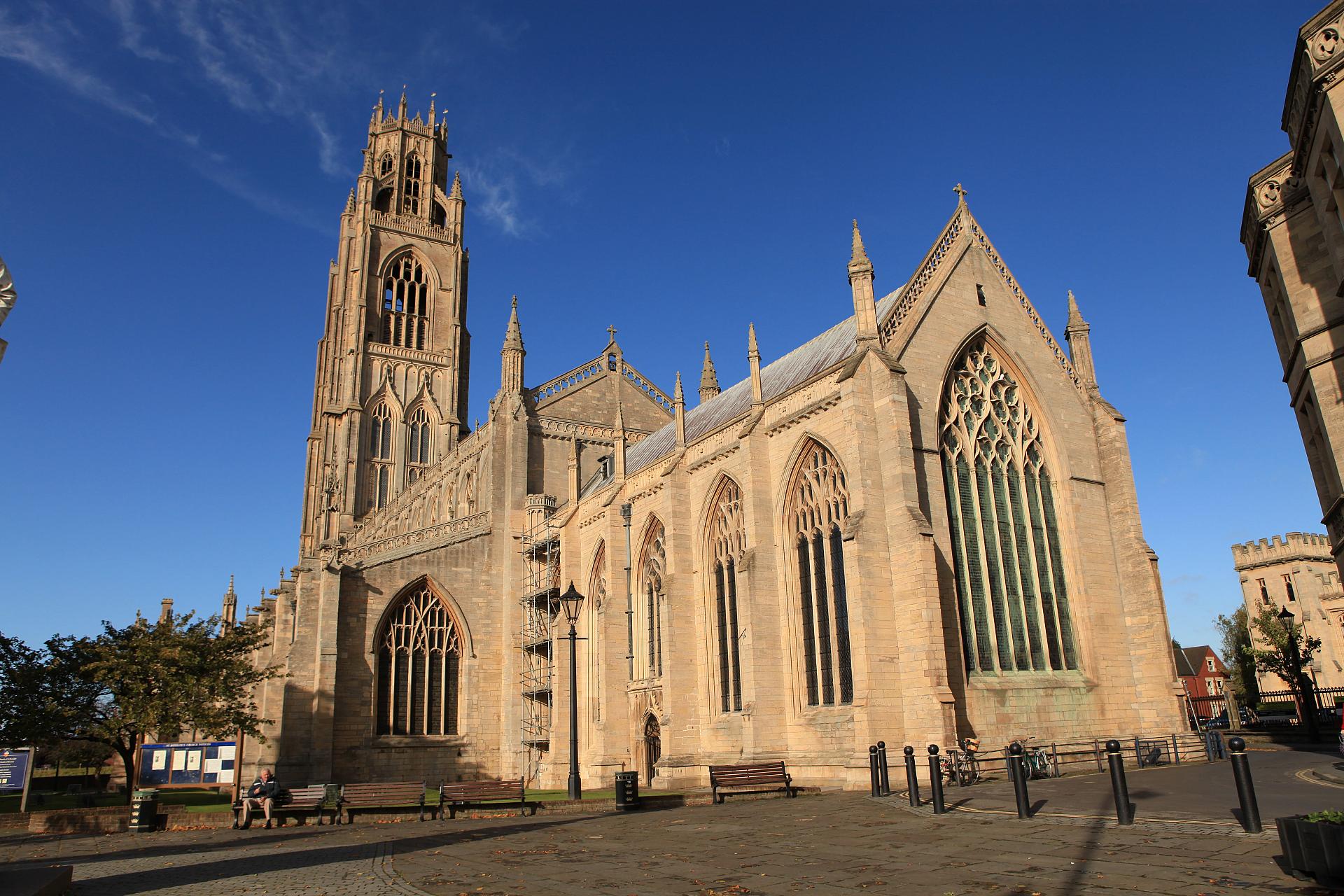
3 St Botolph’s churchyard
The early name for Boston was St Botolph’s town so it’s fitting that we stop here at St Botolph’s church. Its tall tower (affectionately named The Stump!) is accentuated by the flat surrounding agricultural landscape known as The Fens. On a clear day, the tower can be seen from East Anglia on the other side of The Wash.
Daniel Defoe on his tour around the British Isles was quick to point out its elegance and utility; "few spires in England can match it and it is not only beautiful by land, but is very useful at sea to guide pilots into that port".
Boston continued to be a town where dissident religious beliefs flourished. In 1612 a man named John Cotton became the vicar of St Botolph’s Church. He encouraged people who sought religious freedom to emigrate to the New World, following in the footsteps of those first Puritan pioneers.
Eventually Cotton himself made this journey too. It has been estimated that between 1630 and 1640 about one tenth of Boston’s population emigrated to New England! These people helped found the town of Boston in Massachusetts and established many famous institutions, including Harvard University.
See if you can find the twelve stones set on either side of the churchyard path. They mark the impact the members of John Cotton’s congregation had on the world beyond Boston, Lincolnshire.
As you leave the churchyard, pause for a moment by the statue of Herbert Ingram.
We’ve stopped here for a moment to find out about the life of Herbert Ingram, another Boston man who had a great influence on the modern world.
He founded the Illustrated London News, the world’s first illustrated news magazine. In bringing pictures of important events to a wide audience he could be described as the man who invented photo-journalism. Ingram also secured a decent water supply for the town, hence the water pitcher at the base of the statue.
With the front of the church behind you, leave the church yard through the bollards leading to Bank Street (a one way street). Follow this road round to the left as it turns into Red Lion Street, and continue until you reach Norman Avenue on your right. Turn down Norman Avenue and at the end of the road, walk through into the corner of Central Park.
4 Central Park
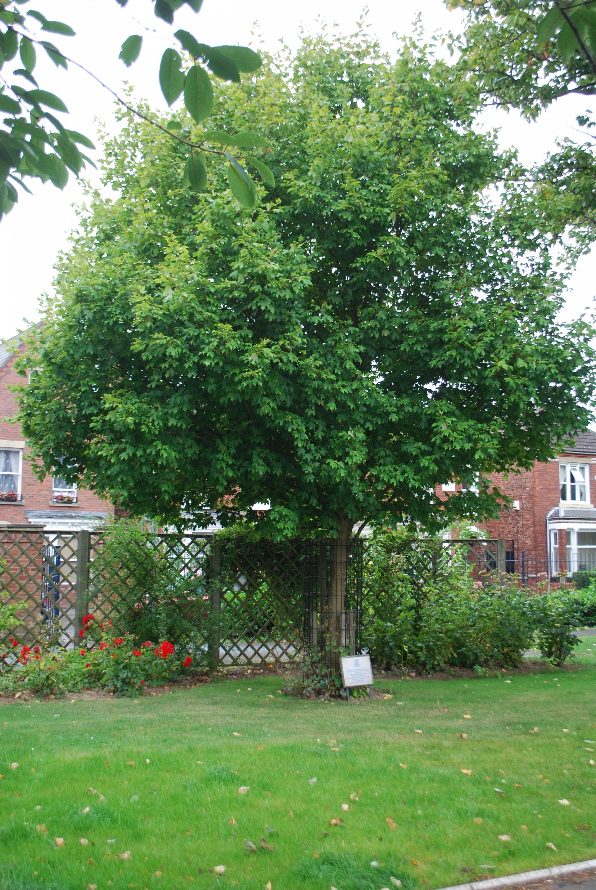
We now meander through the greenery of Central Park – a Victorian addition of tranquillity to Boston’s bustling market town. This park is a bit smaller than the one in New York, but the American connection goes deeper than just the name.
At the far left of the park see if you can find the Sugar Maple tree with a small plaque beneath it. This species normally grows on the eastern seaboard of the USA.
This one was planted as a memorial to those who lost their lives in the 9/11 attacks it is another indicator of the continuing relationship between Boston and the United States.
Exit the park through the gate opposite the one you entered (to the right of the tennis courts). Turn right onto Tawney Street until you reach Wide Bargate at the end of the road. Turn left and follow the roundabout’s second exit (towards Grimsby and Skegness). Immediately before the bridge over the river, take a left and stop on the grassed area overlooking the water.
5 Maud Foster Windmill
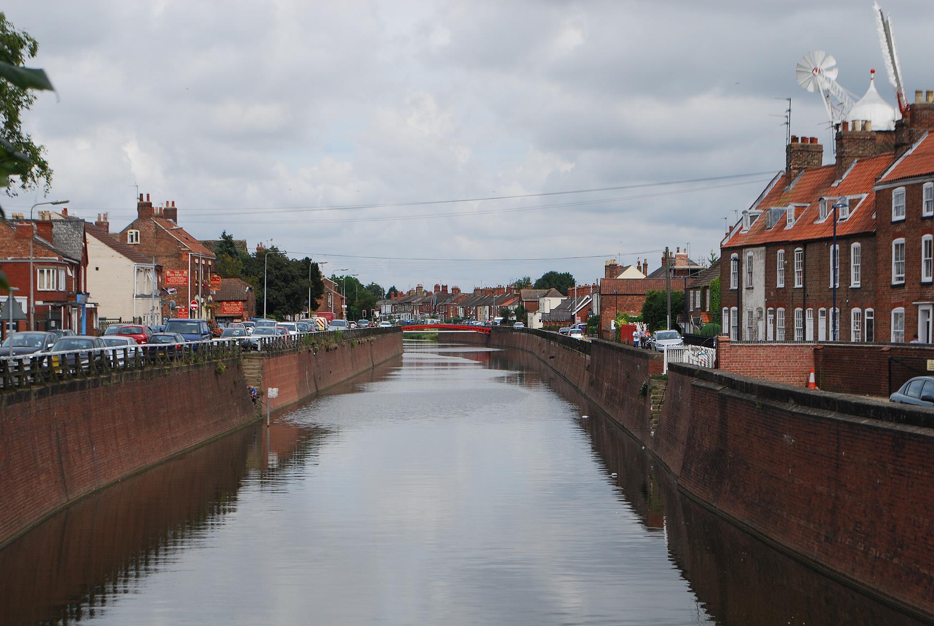
The view from this bridge is so Dutch that you might believe you have stepped through a portal and ended up in Holland! The broad central canal, with roads on either side, is a very common layout in Dutch towns.
The red brick houses with their small dormer windows are also rather Dutch in style. The final contribution to the scene is the windmill. In Holland windmills were used to pump out water from below sea level, and this is a clue as to why it is here.
The Dutch appearance is more than coincidental. In the 17th century several British landowners decided to drain the marshy, wild and flood-prone Fens across Lincolnshire and Norfolk so they could use the land for agriculture.
Landowners realised if they could control the water here these lands could produce crops and generate a handsome income. They turned to Dutch engineers for help because, living in a country where one quarter of the land is under sea level, the Dutch had great experience with land reclamation.
The Dutch drainage techniques (including windmills for pumping water) were quickly taken up across many of the low-lying lands in the east of England. In Boston, the windmill was initially built to harness the power of this watery land to mill grain. In the 19th century it was used to grind bones for making fertilisers, a product that became staple of Boston’s international trade
By this time there were few marshy areas remaining and this region had become one of the main crop-growing areas of England. The Dutch had influenced both the appearance and prosperity of British and Bostonian agriculture.
Return to Wide Bargate, follow the road down its right hand side and stop at the corner of Park Gate. Look out over the market place (which now has a roundabout within it).
6 Wide Bargate, corner of Park Gate
Stop for a moment and take in the layout of these streets and roundabout. Most people probably walk past it without a second thought but it’s worth looking at with a geographer’s eye.
Why has such a large amount of space been allocated to a small roundabout?
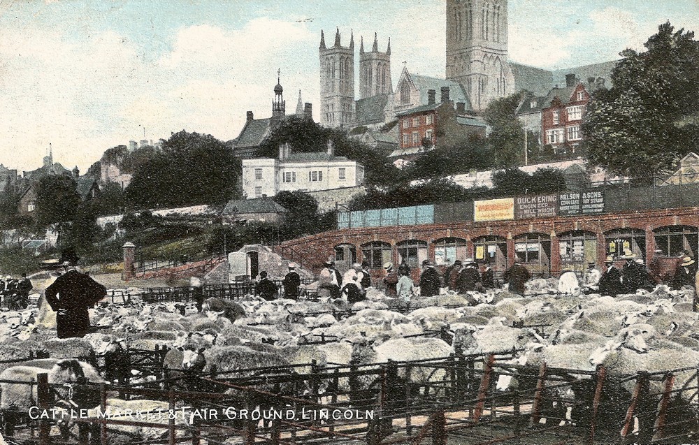
At the start of the trail we learnt how Boston first developed as a port town. This area where the roundabout is today was once a market place where cattle and sheep were paraded and traded. It dates back to the Middle Ages when Boston was a major port for exporting animal products like wool to Europe.
In recent years links with continental European countries have been revived in a very different way. Today Boston has one of the highest concentrations of EU migrant workers of any town in Britain.
Precise figures are difficult to obtain, not least because people are often on the move, but the 2011 census records that about 14% of the local population regard their national identity as non-British and that a large Polish community exists in the town.
Migrant workers are mostly employed in agricultural work, like food processing industries and fruit picking in the surrounding countryside. You may already have heard foreign languages being spoken as you walked around the town but look out too for official notices in Polish, Portuguese and Latvian among others.
The economic and social implications of this modern change are complex and will go on to shape Boston and its surrounding agricultural landscape for years to come.
We’ve now reached the end of the trail. We hope you’ve enjoyed discovering a different side of Boston.
Although it seems tucked away in this quiet corner of Lincolnshire and is much less famous than it’s transatlantic cousin, Boston was trading with the world and sending people out to found new colonies years before Boston Massachusetts was ever dreamt of!
Once a great port trading goods across Europe, Boston continues its global connections today to feed and fuel Britain.

 See if you can spot the impressive building to the right of the Guildhall – Fydell House. In the 1930s a room was set aside here for American visitors to relax and write letters home!